North Cape May, New Jersey
| North Cape May, New Jersey | |
|---|---|
| Census-designated place | |
|
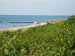
North Cape May shoreline | |
 Map of North Cape May in Cape May County. Inset: Location of Cape May County in New Jersey. | |
| Coordinates: 38°58′35″N 74°57′05″W / 38.976427°N 74.951503°WCoordinates: 38°58′35″N 74°57′05″W / 38.976427°N 74.951503°W | |
| Country |
|
| State |
|
| County | Cape May |
| Township | Lower |
| Area[1] | |
| • Total | 1.494 sq mi (3.870 km2) |
| • Land | 1.457 sq mi (3.773 km2) |
| • Water | 0.037 sq mi (0.096 km2) 2.49% |
| Elevation[2] | 13 ft (4 m) |
| Population (Census 2010)[3] | |
| • Total | 3,226 |
| • Density | 2,214.3/sq mi (854.9/km2) |
| Time zone | Eastern (EST) (UTC-5) |
| • Summer (DST) | Eastern (EDT) (UTC-4) |
| ZIP code | 08204 - Cape May[4] |
| Area code(s) | 609 |
| FIPS code | 3452650[1][5] |
| GNIS feature ID | 02389569[1][6] |
North Cape May is an unincorporated community and census-designated place (CDP) located within Lower Township in Cape May County, New Jersey, United States.[7] It is part of the Ocean City Metropolitan Statistical Area. At the 2010 United States Census, the CDP's population was 3,226.[3][8] The Cape May-Lewes Ferry departs from the area. North Cape May is mostly a residential community, with no hotels but many vacation homes. Many people come here after they retire.
North Cape May had existed as an independent borough, formed by an act of the New Jersey Legislature on March 19, 1928, from portions of Lower Township. The borough remained independent until April 30, 1945, when it was returned to Lower Township.[9] The borough had a population of 5 at the 1930 Census,[10] which increased to 8 by 1940.[11]
Geography
According to the United States Census Bureau, the CDP had a total area of 1.494 square miles (3.870 km2), including 1.457 square miles (3.773 km2) of land and 0.037 square miles (0.096 km2) of water (2.49%).[1][12]
Demographics
| Historical population | |||
|---|---|---|---|
| Census | Pop. | %± | |
| 1970 | 3,812 | — | |
| 1980 | 4,029 | 5.7% | |
| 1990 | 3,574 | −11.3% | |
| 2000 | 3,618 | 1.2% | |
| 2010 | 3,226 | −10.8% | |
| Population sources: 1970-1980[13] 2000[14] 2010[3] | |||
Census 2010
The 2010 United States Census counted 3,226 people, 1,395 households, and 895.6 families residing in the CDP. The population density was 2,214.3 per square mile (854.9/km2). The CDP contained 2,100 housing units at an average density of 1,441.5 per square mile (556.6/km2). The racial makeup of the CDP was 92.87% (2,996) White, 3.22% (104) Black or African American, 0.34% (11) Native American, 0.59% (19) Asian, 0.00% (0) Pacific Islander, 1.30% (42) from other races, and 1.67% (54) from two or more races. Hispanics or Latinos of any race were 3.66% (118) of the population.[3]
Out of a total of 1,395 households, 20.7% had children under the age of 18 living with them, 47.2% were married couples living together, 13.3% had a female householder with no husband present, and 35.8% were non-families. 29.6% of all households were made up of individuals, and 15.2% had someone living alone who was 65 years of age or older. The average household size was 2.30 and the average family size was 2.82.[3]
In the CDP, 18.2% of the population were under the age of 18, 7.7% from 18 to 24, 19.9% from 25 to 44, 31.8% from 45 to 64, and 22.3% who were 65 years of age or older. The median age was 47.6 years. For every 100 females the census counted 88.2 males, but for 100 females at least 18 years old, it was 86.6 males.[3]
Census 2000
As of the 2000 United States Census[5] there were 3,618 people, 1,544 households, and 1,008 families residing in the CDP. The population density was 997.8/km2 (2,583.4/mi2). There were 2,090 housing units at an average density of 576.4/km2 (1,492.3/mi2). The racial makeup of the CDP was 94.42% White, 2.79% African American, 0.44% Native American, 0.47% Asian, 0.75% from other races, and 1.13% from two or more races. Hispanic or Latino of any race were 2.16% of the population.[14]
There were 1,544 households out of which 27.0% had children under the age of 18 living with them, 48.1% were married couples living together, 13.7% had a female householder with no husband present, and 34.7% were non-families. 29.6% of all households were made up of individuals and 15.5% had someone living alone who was 65 years of age or older. The average household size was 2.33 and the average family size was 2.88.[14]
In the CDP the population was spread out with 22.8% under the age of 18, 6.0% from 18 to 24, 26.3% from 25 to 44, 24.2% from 45 to 64, and 20.7% who were 65 years of age or older. The median age was 42 years. For every 100 females there were 86.7 males. For every 100 females age 18 and over, there were 81.3 males.[14]
The median income for a household in the CDP was $37,071, and the median income for a family was $42,161. Males had a median income of $33,036 versus $26,875 for females. The per capita income for the CDP was $18,420. About 1.0% of families and 4.1% of the population were below the poverty line, including 3.1% of those under age 18 and 3.0% of those age 65 or over.[14]
Wineries
 Cape May-Lewes Ferry terminal
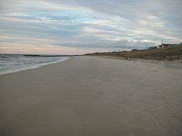 Shoreline near the ferry terminal
References
- 1 2 3 4 Gazetteer of New Jersey Places, United States Census Bureau. Accessed July 21, 2016.
- ↑ U.S. Geological Survey Geographic Names Information System: North Cape May Census Designated Place, Geographic Names Information System. Accessed October 18, 2012.
- 1 2 3 4 5 6 DP-1 - Profile of General Population and Housing Characteristics: 2010 Demographic Profile Data for North Cape May CDP, New Jersey, United States Census Bureau. Accessed October 18, 2012.
- ↑ Look Up a ZIP Code for North Cape May, NJ, United States Postal Service. Accessed October 18, 2012.
- 1 2 American FactFinder, United States Census Bureau. Accessed September 4, 2014.
- ↑ US Board on Geographic Names, United States Geological Survey. Accessed September 4, 2014.
- ↑ New Jersey: 2010 - Population and Housing Unit Counts - 2010 Census of Population and Housing (CPH-2-32), United States Census Bureau, August 2012. Accessed October 18, 2012.
- ↑ Locality Search, State of New Jersey. Accessed April 19, 2015.
- ↑ Snyder, John P. The Story of New Jersey's Civil Boundaries: 1606-1968, Bureau of Geology and Topography; Trenton, New Jersey; 1969. p. 115. Accessed October 18, 2012.
- ↑ "Fifteenth Census of the United States: 1930 - Population Volume I", United States Census Bureau, p. 715. Accessed October 18, 2012.
- ↑ "Sixteenth Census of the United States: 1940 - Population Volume I; Number of Inhabitants", United States Census Bureau, p. 676. Accessed October 18, 2012.
- ↑ US Gazetteer files: 2010, 2000, and 1990, United States Census Bureau. Accessed September 4, 2014.
- ↑ Staff. 1980 Census of Population: Number of Inhabitants United States Summary, p. 1-141. United States Census Bureau, June 1983. Accessed June 28, 2015.
- 1 2 3 4 5 DP-1 - Profile of General Demographic Characteristics: 2000 from the Census 2000 Summary File 1 (SF 1) 100-Percent Data for North Cape May CDP, New Jersey, United States Census Bureau. Accessed October 18, 2012.
External links
Municipalities and communities of Cape May County, New Jersey, United States | ||
|---|---|---|
| Cities | 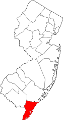 | |
| Boroughs | ||
| Townships | ||
| CDPs | ||
| Other unincorporated communities | ||