Interstate 80 in New Jersey
| ||||
|---|---|---|---|---|
| Christopher Columbus Highway | ||||
|
I-80 highlighted in red | ||||
| Route information | ||||
| Maintained by NJDOT | ||||
| Length: | 68.54 mi[1] (110.30 km) | |||
| Existed: | 1973 – present | |||
| Major junctions | ||||
| West end: |
| |||
|
| ||||
| East end: |
| |||
| Location | ||||
| Counties: | Warren, Sussex, Morris, Essex, Passaic, Bergen | |||
| Highway system | ||||
| ||||
.svg.png)
_map.svg.png)
Interstate 80 (I-80) is a major Interstate Highway in the United States, running from the New York City Metropolitan Area westward to San Francisco, California. The New Jersey Department of Transportation also identifies I-80 as the Christopher Columbus Highway.[1] I-80 in New Jersey runs 68.54 miles (110.30 km) from the Delaware Water Gap Toll Bridge over the Delaware River at the Delaware Water Gap to its eastern terminus at I-95 in Teaneck, Bergen County. I-95 continues from the end of I-80 to the George Washington Bridge for access to New York City; access is also provided via the I-280 spur towards the Holland Tunnel and US 46 to Route 3, or I-95, towards the Lincoln Tunnel. Throughout New Jersey, I-80 runs parallel to US 46. The highway heads through rural areas of Warren and Sussex counties before heading into more suburban surroundings in Morris County. As the road continues into Passaic and Bergen counties, it heads into more urban areas.
A freeway along the I-80 corridor had been planned in 1936 and again in 1955 to provide relief along US 46 between the George Washington Bridge and the Delaware Water Gap. With the establishment of the Interstate Highway System, this planned freeway, which had been identified in some planning documents as the Bergen-Passaic Expressway, would be incorporated into I-80. The freeway was built across New Jersey in various stages from the 1960s to 1973. The westernmost four miles in New Jersey was originally a rerouting of US 611 when built; that route was later realigned back into Pennsylvania. In the 1990s, high-occupancy vehicle lanes had existed on a part of I-80 in Morris County but were opened to regular traffic due to underuse. The Delaware Water Gap Toll Bridge and its approach is planned to be widened from four to six lanes, with construction beginning in 2015.
Route description
Warren and Sussex counties

I-80 enters Hardwick Township, Warren County from Pennsylvania on the Delaware Water Gap Toll Bridge over the Delaware River, maintained by the Delaware River Joint Toll Bridge Commission.[1] In addition to carrying I-80, this bridge also carries the Appalachian Trail over the Delaware River. From this point, the four-lane freeway heads south along the east bank of the river through the Delaware Water Gap, immediately reaching a westbound exit and eastbound entrance for Old Mine Road.[1][2] Now maintained by the New Jersey Department of Transportation, the road makes a sharp turn to the east and comes to a U-turn ramp in both directions that also has access to the Appalachian Trail.[1] The highway heads south again and enters Knowlton Township, where it comes to another set of U-turn ramps that also includes a weigh station in the eastbound direction. After turning southeast and leaving the Delaware Water Gap, the road has a westbound right-in/right-out for Hainesburg Road before crossing under the abandoned Lackawanna Cutoff. I-80 widens to six lanes and reaches a large interchange with the western terminus of US 46, Route 94, and Decatur Street in Columbia, where development near the route increases. After this interchange, the freeway turns east away from the Delaware River and crosses over Paulins Kill before it continues through wooded and hilly areas containing some farms, with the eastbound direction widening from three to four lanes and the highway median also widens. A scenic overlook of the Delaware Water Gap is located in the westbound direction while a rest area is located in the eastbound direction.[1][2]
Upon crossing into Blairstown Township, the eastbound direction narrows down to three lanes.[1] In Hope Township, I-80 reaches an interchange with CR 521 that also provides access to CR 519 and the Land of Make Believe amusement park.[1][2] The highway widens to eight lanes briefly after this interchange before narrowing to six lanes. In Frelinghuysen Township, the freeway carries four lanes eastbound and three lanes westbound. Upon coming into Allamuchy Township, I-80 has six lanes before gaining a fourth eastbound lane as it comes to the CR 517 exit.[1] This exit gives the highway access to Allamuchy Mountain State Park.[2] Following this, the road runs through densely forested areas of Allamuchy Mountain State Park, coming to two pairs of rest areas with no facilities in both directions. The eastbound direction becomes three lanes again before the road passes through Byram Township in Sussex County.[1][2]
Morris and Essex counties
Upon crossing the Musconetcong River, I-80 enters Mount Olive Township in Morris County and passes through more woodland with a narrower median. The road comes to a trumpet interchange with US 206 and forms a concurrency with that route as it bypasses Netcong to the south. After turning southeast and passing near suburban business parks, the highway crosses over New Jersey Transit’s Morristown Line/Montclair-Boonton Line and reaches the US 46 partial interchange.[1][2] This interchange has only a westbound exit and eastbound entrance. The freeway crosses a small corner of Netcong and Mount Olive Township again before continuing into Roxbury Township, where it comes to a modified cloverleaf interchange.[1] At this interchange, Route 183 heads north into Netcong and US 206 splits from I-80 by heading south. The road continues through wooded areas containing some suburban development as it comes to the CR 631 interchange, which also provides access to eastbound US 46.[1][2] The road crosses the New Jersey Transit line again and parallels it a short distance to the north as it comes into Mount Arlington and reaches the Howard Boulevard exit.[1] I-80 continues back into Roxbury Township and comes to a westbound truck rest area with the eastbound one being abandoned.[1][3][4] After this, the road heads farther north of the railroad tracks and briefly passes through Jefferson Township and Rockaway Township before continuing into Wharton. Here, the freeway has an eastbound exit to CR 634 that provides access to Route 15 before it reaches the interchange with Route 15 proper that lacks an eastbound exit.[1]

The highway continues back into Rockaway Township as it widens to eight lanes and comes to the CR 661 exit near the Rockaway Townsquare shopping mall. Suburban development near the highway becomes more dense at this point as I-80 briefly passes through a corner of Rockaway before coming to the interchange with CR 513 in Rockaway Township.[1][2] The freeway turns southeast here into Denville. In the center of Denville, it has an eastbound exit and westbound entrance serving US 46 that also provides access to Route 53. There is a westbound exit and eastbound entrance serving both US 46 and Route 53 as the road begins to turn more to the east. I-80 turns south and crosses the New Jersey Transit Montclair-Boonton Line before it enters Parsippany-Troy Hills.[1] The highway makes a turn east as it comes into an area of business parks, with the median widening before an interchange serving US 202 and CR 654.[1][2] The median narrows again before I-80 reaches the I-287 interchange that also has movements to US 46 and Smith Road to and from the east.[1]
Past I-287, I-80 gains local-express lanes with a 2-3-3-2 configuration.[1] The road continues past more commercial areas, with the local lanes having an eastbound exit and westbound entrance at CR 637.[1][2] After this, there is a large interchange with US 46 and the western terminus of I-280, at which point the local-express lanes end.[1] From this point, I-80 continues east through wooded areas as a six-lane freeway, crossing into Montville.[1][2] In Montville, there is a partial interchange providing access to Hook Mountain Road.[1] After a turn to the northeast, the highway comes into Fairfield Township, Essex County, continuing through wooded surroundings as it heads north before turning east. Development near the road increases as it comes to the westbound exit and eastbound entrance with CR 613.[1][2]
Passaic and Bergen counties
After crossing the Passaic River again, I-80 enters Wayne in Passaic County.[1] Here, the road passes under the Montclair-Boonton Line before coming to the Spaghetti Junction with Route 23 and US 46 near the Willowbrook Mall. At this point, the freeway widens to eight lanes and continues into Totowa, passing near more commercial areas as it comes to an interchange with CR 642 that has access to and from the west.[1][2] A short distance later, there is a westbound exit and eastbound entrance serving Route 62 and CR 646.[1] I-80 crosses the Passaic River a third time and enters Woodland Park, where it turns to the northeast past suburban neighborhoods.[1][2] In Woodland Park, there is an interchange serving CR 636.[1] Past this, the freeway enters Paterson and turns east into urban areas as it comes to the interchange at the Route 19 freeway. After Route 19, I-80 runs above Paterson on a viaduct before coming to the exit for CR 649 (Madison Avenue). The road returns to ground level near urban neighborhoods as it comes to an eastbound exit and westbound entrance serving Market Street.[1][2] A short distance later, I-80 encounters Route 20 at an interchange.[1]

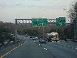
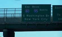
After a fourth crossing of the Passaic River, I-80 comes into Elmwood Park in Bergen County. Immediately after the river, the highway reaches the CR 507 exit.[1] It continues near suburban neighborhoods as it comes to an interchange with the Garden State Parkway on the border of Elmwood Park and Saddle Brook that also has connections to CR 67.[1][2] At the Garden State Parkway, I-80 gains a 2-2 local-express lane configuration eastbound while the westbound direction carries four lanes. The next interchange along the road is with CR 79, and is a westbound entrance and an eastbound exit accessible from the local lanes. The freeway turns south along the west bank of the Saddle River, eventually crossing it into Lodi.[1] Immediately after, there is a diamond interchange at Riverview Avenue that provides access to Route 4 and Route 17. Heading southeast, I-80 comes to an interchange at Route 17, which provides access to US 46 to the south, Route 4 to the north, and various local roads. At this point, I-80 runs between the travel lanes of Route 17 as it continues into Hackensack. Past Route 17, I-80 gains a 3-2-2-3 local-express lane configuration and passes industrial parks, running through a small part of South Hackensack.[1][2] Here, there is an interchange to Green Street before the highway comes into Teterboro. Turning east, the freeway runs through South Hackensack before entering Hackensack, where an exit provides access to CR 124 (Hudson Street).[1] The road passes near neighborhoods before crossing the Hackensack River into Ridgefield Park, where there is an exit for 2nd Avenue.[1][2] The freeway passes through a corner of Bogota before it continues into Teaneck.[1][2] In Teaneck, I-80 reaches its eastern terminus at the interchange with I-95 (the New Jersey Turnpike). At this point, I-95 and the Turnpike continue north towards the George Washington Bridge.[1][2]
History
A freeway along the I-80 corridor was first planned in 1936 as a replacement for the cross-state US 46, running from the George Washington Bridge west to the Delaware Water Gap and Scranton, Pennsylvania.[5] This proposal was considered again in 1955. Coming off the George Washington Bridge, Route 4 and US 46 already provided high-speed corridors, but they were overloaded, and so a new corridor in between, the Bergen-Passaic Expressway, was planned to run from the bridge to Paterson.[6] The planned route west to the Delaware Water Gap was designated in 1956 as Federal Aid Interstate Route 101 by the New Jersey State Highway Department.[7] It first received the I-82 designation before finally becoming a part of I-80 in 1958.[8][9] The easternmost section of the route, leading to the bridge, had become part of I-95.[9]
The section of I-80 through the Delaware Water Gap had already opened on December 16, 1953, running from the Delaware Water Gap Toll Bridge to Route 94 at Columbia.[10] This road was signed as a realignment of US 611 from Pennsylvania, later receiving the I-80 designation. The old alignment of US 611 in Pennsylvania had become US 611 Alternate.[11][12] In the 1960s, the US 611 alignment was moved back to the Pennsylvania side of the river. By 1966, I-80 had been completed from Netcong to Denville and from Paterson to I-95.[12] By 1969, the section between I-280 in Parsippany and Route 23 in Wayne was finished. Also around this time, US 611 was moved off of I-80 and back into Pennsylvania, replacing US 611 Alternate.[13] By 1971, the section between Wayne and Paterson was completed along with the part between US 202 and I-280.[14] A 3½-mile section between US 46 in Denville and US 202 Parsippany-Troy Hills, was opened in September 1973.[15] Also in 1973, the section between US 206 in Netcong and US 46 and Route 94 in Columbia was completed, and the interchange in Columbia was realigned into a complex array of ramps.[16]
In the 1990s, high-occupancy vehicle lanes were built along I-80 between Rockaway and Parsippany. These HOV lanes, along with the ones that had been built on I-287, were opened to regular traffic in 1998 due to lack of usage, and the state did not have to repay the federal government the $240 million to build the lanes.[17] On June 22, 2001, a tanker crashed on a westbound bridge on I-80 in Denville, causing a fiery explosion that damaged the bridge and forced its demolition.[18] A temporary bridge had to be built and traffic on this part of I-80 as well as adjacent roads was snarled; in addition, a state of emergency had been declared for Morris County.[19] The new I-80 bridge opened in September 2001.[20]
I-80, like many other highways in New Jersey, once had solar powered emergency call boxes every 1 mile (1.6 km), however with the advent of cell phones the usage of these call boxes became extremely limited. To save on maintenance costs, the NJDOT removed these call boxes in 2005.[21] The Delaware River Joint Toll Bridge Commission is going to widen the Delaware Water Gap Toll Bridge that carries I-80 over the Delaware River to six lanes. This project is not planned to begin until 2015.[22]
Exit list
| County | Location | mi[1] | km | Exit | Destinations | Notes |
|---|---|---|---|---|---|---|
| Warren | Delaware River | 0.00 | 0.00 | – | Continuation into Pennsylvania; toll booths across state line | |
| Delaware Water Gap Toll Bridge (Westbound toll, cash or E-ZPass) | ||||||
| Hardwick Township | 0.10 | 0.16 | 1 | Millbrook, Flatbrookville | Via Old Mine Road | |
| 0.87 | 1.40 | – | Delaware Water Gap National Recreation Area | Access to u-turn and Appalachian Trail | ||
| Knowlton Township | 2.05 | 3.30 | Weigh station | |||
| 3.39 | 5.46 | 3 | Hainesburg Road | Westbound exit and entrance | ||
| 4.20 | 6.76 | 4A | Columbia | Westbound exit is via exit 4B; via Decatur Street | ||
| 4.58 | 7.37 | 4B | Western terminus of US 46 | |||
| 4C | ||||||
| Hope Township | 12.03 | 19.36 | 12 | |||
| Allamuchy Township | 19.88 | 31.99 | 19 | |||
| Morris | Mount Olive Township | 25.25 | 40.64 | 25 | West end of concurrency with US 206 | |
| Netcong | 26.25 | 42.25 | 26 | Westbound exit and eastbound entrance | ||
| Roxbury Township | 27.19 | 43.76 | 27A | East end of concurrency with US 206 | ||
| 27B | ||||||
| 28.91 | 46.53 | 28 | ||||
| Mount Arlington | 30.61 | 49.26 | 30 | Howard Boulevard (CR 615) – Mount Arlington | ||
| Wharton | 33.58 | 54.04 | 34 | Eastbound exit only | ||
| 34.02 | 54.75 | No eastbound exit; signed as exits 34A (south) and 34B (north) | ||||
| Rockaway Township | 35.33 | 56.86 | 35 | Mount Hope, Dover | Signed as exits 35A (south) and 35B (north) westbound; access via CR 661 | |
| 37.63 | 60.56 | 37 | ||||
| Denville | 38.81 | 62.46 | 38 | Eastbound exit and westbound entrance; to Denville Station | ||
| 39.57 | 63.68 | 39 | Westbound exit and eastbound entrance; to Denville Station | |||
| Parsippany-Troy Hills | 42.46 | 68.33 | 42A | |||
| 42B | No eastbound exit | |||||
| 42C | Eastbound exit and westbound entrance | |||||
| 43.62 | 70.20 | 43 | Signed as exits 43A (south) and 43B (north) westbound; exit 41 on I-287 | |||
| Western terminus of local-express lanes | ||||||
| – | Westbound exit and eastbound entrance via exit 43B | |||||
| 45.34 | 72.97 | 45 | Lake Hiawatha, Whippany | Eastbound exit and westbound entrance via CR 637 | ||
| 46.36 | 74.61 | 47A | Eastbound exit and westbound entrance | |||
| Eastern terminus of local-express lanes | ||||||
| 46.50 | 74.83 | 47B | Eastbound exit and westbound entrance | |||
| 47 | Westbound exit and eastbound entrance | |||||
| Montville | 47.83 | 76.97 | 48 | Montville, Pine Brook | Westbound exit and eastbound entrance; access via Hook Mountain Road | |
| Essex | Fairfield Township | 52.48 | 84.46 | 52 | Lincoln Park, Fairfield, The Caldwells | Westbound exit and eastbound entrance via CR 613 |
| Passaic | Wayne | 53.62 | 86.29 | 53 | Eastbound exit and westbound entrance; access to Meadowlands Sports Complex | |
| Westbound exit and eastbound entrance | ||||||
| Totowa | 54.73 | 88.08 | 54 | Minnisink Road (CR 642) – Little Falls, Totowa | Eastbound exit and westbound entrance | |
| 55.21 | 88.85 | 55 | Route 62 south / Union Boulevard (CR 646) – Little Falls, Totowa | Westbound exit and eastbound entrance; signed as exits 55A (south) and 55B (north) | ||
| Woodland Park | 57.07 | 91.85 | 56 | Squirrelwood Road (CR 636) – Woodland Park, Paterson | Signed as exits 56A (south) and 56B (north) eastbound | |
| Paterson | 58.22 | 93.70 | 57A | |||
| 57B | Downtown Paterson | |||||
| 58.37 | 93.94 | 57C | Main Street (CR 509) – Paterson | Westbound exit and eastbound entrance | ||
| 59.06 | 95.05 | 58 | Madison Avenue (CR 649) – Paterson, Clifton | Signed as exits 58A (south) and 58B (north) | ||
| 60.04 | 96.63 | 59 | Market Street – Paterson | Westbound exit and eastbound entrance | ||
| 60.41 | 97.22 | 60 | Westbound exit to Route 20 south is via exit 59 | |||
| Bergen | Elmwood Park | 60.81 | 97.86 | 61 | ||
| Saddle Brook | 62.34 | 100.33 | 62A | Signed as exit 62 westbound | ||
| Western terminus of local-express lanes | ||||||
| 62B | Saddle River Road (CR 79) – Fair Lawn, Lodi | Eastbound exit and westbound entrance | ||||
| Lodi | 63.82 | 102.71 | 63 | |||
| Eastern terminus of local-express lanes | ||||||
| Hackensack | 65.19 | 104.91 | 64A | Westbound exit and eastbound entrance | ||
| 65.05– 65.19 | 104.69– 104.91 | 64 | Eastbound exit and westbound entrance | |||
| 65.40 | 105.25 | 64B | Westbound exit and eastbound entrance | |||
| Teterboro | 65.67 | 105.69 | 65 | Green Street – Teterboro, South Hackensack | ||
| Hackensack | 66.55 | 107.10 | 66 | Hudson Street (CR 124) – Hackensack, Little Ferry | ||
| Ridgefield Park | 67.22 | 108.18 | 67 | Bogota, Ridgefield Park | Eastbound exit and westbound entrance via 2nd Avenue | |
| Teaneck | 68.17 | 109.71 | 68A | I-95 exit 69; eastbound exit and westbound entrance. | ||
| 68.54 | 110.30 | 68B | No exit number eastbound, eastern terminus | |||
1.000 mi = 1.609 km; 1.000 km = 0.621 mi
| ||||||
Auxiliary routes
-
 I-280, known locally as the Essex Freeway
See also
- List of crossings of the Upper Passaic River
-
 U.S. Roads portal
 -
 New Jersey portal
References
- 1 2 3 4 5 6 7 8 9 10 11 12 13 14 15 16 17 18 19 20 21 22 23 24 25 26 27 28 29 30 31 32 33 34 35 36 37 38 39 40 41 42 "I-80 Straight Line Diagram" (PDF). New Jersey Department of Transportation. Retrieved 2009-12-13.
- 1 2 3 4 5 6 7 8 9 10 11 12 13 14 15 16 17 18 19 20 Google (2010-01-14). "overview of Interstate 80 in New Jersey" (Map). Google Maps. Google. Retrieved 2010-01-14.
- ↑ "NJDOT Traffic Regulations - Traffic and Parking in Rest Areas - Interstate 80". New Jersey Department of Transportation. Retrieved 2010-01-15.
- ↑ I-80 eastbound at abandoned weigh station (Map). Google Street View. 2010. Retrieved 2010-01-15.
- ↑ "Freeways Are Now Urged". The New York Times. December 13, 1936.
- ↑ Joint Study of Arterial Facilities. Port of New York Authority and Triborough Bridge and Tunnel Authority. 1955.
- ↑ Wright, George Cable (March 5, 1958). "Jersey Acts To Speed U.S. Aid for Its $388.5 Million Freeway". The New York Times.
- ↑ Official Numbering for the National System of Interstate and Defense Highways (Map). American Association of State Highway and Transportation Officials. 1957. Retrieved 2010-01-13.
- 1 2 Wright, George Cable (September 19, 1958). "New Roads with New Numbers Will Parallel Old U.S. Routes". The New York Times.
- ↑ "New Span Crosses Delaware River; Fine, Driscoll at Ceremonies for Water Gap Bridge -- Road to Link Poconos and New York". The New York Times. December 17, 1953. p. 51.
- ↑ Pennsylvania State Transportation (PDF) (Map). PennDOT. 1960. § 1. Retrieved 2010-01-15.
- 1 2 United States featuring the Interstate Highway System (Map). Cartography by General Drafting. Esso. 1966.
- ↑ Map of New Jersey (Map). Cartography by H.M. Gousha. Chevron Oil Company. 1969.
- ↑ Shipler, David K. (August 19, 1971). "New Highways Shaping Future of City's Suburbs; New Superhighways Shaping Future of City's Suburbs". The New York Times.
- ↑ Burks, Edward C. (September 15, 1973). "Vital Stretch of Route 80 Opens In Jersey, Ending Big Bottleneck; Stretch of Route 80 Opens And Eliminates Bottleneck". The New York Times.
- ↑ "Missing Link of I-80 Opened in Ceremony Near Columbia". The New York Times. November 9, 1973.
- ↑ Berger, Joseph (December 1, 1998). "Our Towns; H.O.V. Lanes: A 30-Mile Test That Failed". The New York Times. Retrieved 2009-12-22.
- ↑ Murphy, Dean E. (June 24, 2001). "Drivers May Face Months of Delays After Fiery Crash Forces Demolition of I-80 Span". The New York Times. Retrieved 2010-01-15.
- ↑ "Metro Briefing - New Jersey: Trenton: Route 80 Emergency Declared". The New York Times. July 4, 2001. Retrieved 2010-01-15.
- ↑ "NJDOT Will Begin Work To Re-Open I-80 In Morris County". New Jersey Department of Transportation. September 5, 2001. Retrieved 2010-01-15.
- ↑ Barlas, Thomas (February 28, 2007). "Last call for N.J.'s roadside call boxes". The Press of Atlantic City.
- ↑ "Delaware Water Gap (I-80) Toll Bridge ORT/Express E-ZPass Project". Delaware River Joint Toll Bridge Commission. Retrieved 2010-01-15.
External links
| Wikimedia Commons has media related to Interstate 80 in New Jersey. |
| Previous state: Pennsylvania |
New Jersey | Next state: Terminus |