U.S. Route 22 in New Jersey
| ||||
|---|---|---|---|---|
|
US 22 highlighted in red | ||||
| Route information | ||||
| Maintained by NJDOT and DRJTBC | ||||
| Length: | 60.53 mi[1] (97.41 km) | |||
| Major junctions | ||||
| West end: |
| |||
|
| ||||
| East end: |
| |||
| Location | ||||
| Counties: | Warren, Hunterdon, Somerset, Union, Essex | |||
| Highway system | ||||
| ||||

_map.svg.png)
U.S. Route 22 (US 22) is a U.S. highway stretching from Cincinnati, Ohio in the west to Newark, New Jersey in the east. In New Jersey, the route runs for 60.53 mi (97.41 km) from the Easton-Phillipsburg Toll Bridge over the Delaware River in Phillipsburg, Warren County to Interstate 78 (I-78), US 1/9, and Route 21 at the Newark Airport Interchange in Newark, Essex County. The road first heads through the Phillipsburg-Alpha area as a surface divided highway before running concurrent with I-78 through mountainous and agricultural sections of western New Jersey between Alpha and east of Clinton in Hunterdon County. For the remainder of the route, US 22 runs to the south of I-78 through mostly suburban areas as a four- to six-lane surface divided highway, passing through Hunterdon, Somerset, Union, and Essex counties. Along this portion, it intersects US 202 and US 206 in Somerville, I-287 in Bridgewater Township, and the Garden State Parkway in Union.
What became US 22 in 1926 was first designated as pre-1927 Route 9 in 1916, a route running from Phillipsburg to Elizabeth. In 1927, pre-1927 Route 9 west of Elizabeth became Route 28 while the portion within Elizabeth became Route 27-28 Link. By 1941, US 22 was moved to its current alignment in the Phillipsburg area, following Route 24 and Route 24-28 Link; Route 28 in Phillipsburg became US 22 Alternate (now Route 122). Also, US 22 was moved off Route 28 east of Bridgewater Township to follow Route 28-29 Link and Route 29 to Newark. In 1953, the long concurrencies with the state highways were removed. In the 1960s, I-78 was constructed close to the US 22 corridor throughout New Jersey. US 22 was moved onto the new interstate between Alpha and Clinton in 1969 with most of the old route becoming Route 173.
Route description
Phillipsburg-Alpha area
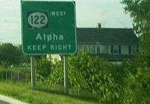
US 22 enters New Jersey from Easton, Pennsylvania on the Easton-Phillipsburg Toll Bridge over the Delaware River.[2] It heads into Phillipsburg, Warren County as a four-lane undivided road maintained by the Delaware River Joint Toll Bridge Commission, eventually becoming a divided highway.[1][2] East of the bridge, the westbound lanes pass through the bridge toll plaza, and the route has an eastbound exit and westbound entrance for Broad and Main Streets.[1] From the previous exit, US 22 runs eastward as a brief limited-access road maintained by the New Jersey Department of Transportation that ends in an interchange with Morris Street and Hillcrest Boulevard.[1] At this point, the route becomes at-grade Memorial Boulevard; a commercial four to six-lane divided thoroughfare with a wide median consisting of U-turn ramps and jughandles. The median narrows as the road forms the border between Lopatcong Township to the north and Phillipsburg to the south.[1][2] The route fully enters Lopatcong Township and comes to an interchange with Route 57, with an eastbound exit and a westbound entrance.[1] After passing the Route 57 junction, US 22 takes a southeasterly turn and passes over Norfolk Southern's Washington Secondary before entering an agricultural area. The route forms the border between Pohatcong Township to the west and Greenwich Township to the east as it passes to the east of the Phillipsburg Mall. A short distance later, US 22 intersects CR 519 before heading back into a business district and meeting CR 638. East of Alpha, the route intersects Route 122, which is the final junction of the at-grade section of US 22.[1][2]
I-78/US 22 concurrency
Past the Route 122 intersection, US 22 has an interchange with exit 3 of I-78 and the western endpoint of Route 173. From there, US 22 is concurrent with I-78 through a mountainous and rural area of western New Jersey.[1][2] I-78/US 22 follow a six-lane freeway east through Greenwich Township, coming to a westbound exit and eastbound entrance with CR 637. The road turns southeast and has an eastbound exit and westbound entrance with CR 632 in Franklin Township.[1] Within the ramps for this interchange, there are weigh stations in both directions.[2] A short distance after this interchange, I-78/US 22 crosses the Musconetcong River into Bloomsbury, Hunterdon County. In Bloomsbury, the road has an interchange with Route 173.[1] After this interchange, the freeway enters Bethlehem Township, with Route 173 closely running to the north of I-78/US 22.[1][2] The road has rest areas in both directions before it passes over Norfolk Southern's Lehigh Line and turns southeast to cross the Musconetcong Mountains.[2]
The freeway turns east again and enters Union Township, coming to an interchange with CR 614 and Route 173.[1] From here, I-78/US 22 continue east directly to the south of Route 173, coming to another interchange with that route as well as CR 625. Entering more commercial areas, Route 173 merges onto I-78/US 22 at exit 13.[1][2] At exit 15, the highway meets an interchange with CR 513, and Route 173 splits from I-78/US 22 by heading north on CR 513. At this point, the freeway runs along the border of Franklin Township to the south and Clinton to the north before entirely entering Clinton and crossing the South Branch Raritan River.[1] I-78/US 22 turns northeast and leaves Clinton for Clinton Township, where it has an eastbound exit and westbound entrance for Route 173 that also provides access to Route 31.[1][2] Immediately after is the interchange with Route 31.[1] At the next interchange near the community of Annandale, US 22 splits from I-78, heading closely to the south of that route.[1][2]
Annandale to Somerville
Upon splitting from I-78, US 22 becomes a four-lane at-grade divided highway that runs through rural areas with some development and crosses New Jersey Transit’s Raritan Valley Line. It enters Lebanon, passing to the north of the town center. Upon leaving Lebanon, the route heads back into Clinton Township. In the community of Potterstown, US 22 enters Readington Township and takes a southeasterly turn away from I-78. Here, the road passes to the southwest of the Merck Headquarters Building before reaching the community of Whitehouse Station, where it has a short concurrency with CR 523.[1][2] Past Whitehouse Station, US 22 continues through a mix of residential and commercial areas.[2]
US 22 continues into Branchburg Township, Somerset County, where development near the road increases but remains mostly rural. CR 614 parallels US 22 to the north to pass through the community of North Branch before US 22 intersects CR 637 and crosses the North Branch Raritan River into Bridgewater Township.[1][2] In Bridgewater Township, the route comes to an interchange with the eastern terminus of CR 614 and the western terminus of Route 28.[1] Past this interchange, US 22 passes business parks and the Raritan Valley Country Club, widening to six lanes in the process. Afterwards, it comes to an interchange with US 202 and US 206. Past this interchange, US 22 quickly transitions from a rural to a more suburban setting and heads east along the border of Somerville to the south and Bridgewater Township to the north, passing near the Bridgewater Commons shopping mall. The median of the route widens as it runs immediately to the south of I-287, fully entering Bridgewater Township again as it comes to an interchange with I-287 at exits 14A and 14B.[1][2]
I-287 to Garden State Parkway
East of I-287, US 22 continues east as a four-lane divided highway passing to the south of the Watchung Mountains.[2] The route then has an interchange with CR 525, where the wide grassy median narrows to a Jersey barrier. The road continues through wooded surroundings and passes through a portion of Bound Brook, widening back to six lanes before meeting CR 527 at an interchange.[1][2] From here, the route takes a northeasterly course, entering Bridgewater Township again and narrowing to four lanes before crossing into Green Brook Township while designated a short distance north of the Middlesex-Somerset County border.[1] US 22 continues through business areas as a highway with jughandles, crossing CR 529.[1][2] In North Plainfield, the route widens to six lanes and has an interchange with CR 531. Past this interchange, the road continues along the border of Watchung to the west and North Plainfield to the southeast before crossing Green Brook.[1]
At this crossing, US 22 heads north-northeast into Scotch Plains, Union County, coming to an interchange with CR 655.[1] The route continues northeast as a four- to five-lane highway, passing near Bowcraft Amusement Park.[2] The road continues east through Mountainside, turning northeast before entering Springfield, where it has an interchange with CR 509 Spur (signed as CR 577).[1][2] Past this interchange, for 1.8 miles US 22 has an unusual wide median that contains commercial businesses and numerous U-turn ramps. In this area, the road comes to a level crossing with the abandoned Rahway Valley Railroad.[2] It crosses the Rahway River into Union, where the wide median continues. The route briefly forms the northern border of Kenilworth before the median narrows back into a Jersey barrier. US 22 splits into two carriageways at the intersection with exits 140 and 140A of the Garden State Parkway and Route 82, site of the Union Watersphere.[1][2]
Hillside to Newark Airport Interchange
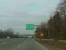
Past this interchange, the route comes to an exit for CR 630 before crossing the Elizabeth River into Hillside, where it heads east through more urban areas.[1][2] The road has an interchange at Bloy Street before passing over CR 509. After an interchange with Broad Street, US 22 turns northeast as a limited-access roadway.[1] It heads into Newark in Essex County, where the highway passes through wooded Weequahic Park. Past the park, US 22 turns to the east into urban areas and closely runs to the south of I-78, where it comes to an eastbound exit and westbound entrance for Empire Street, which provides access to Route 27.[1][2] A short distance later, the freeway has a direct westbound exit and eastbound entrance with Route 27.[1] Past this interchange, US 22 continues parallel to I-78, passing over Amtrak’s Northeast Corridor before reaching the Newark Airport Interchange; south of downtown Newark and northwest of Newark Liberty International Airport.[1][2] US 22 eastbound merges with US 1-9, with one southbound ramp and two northbound ramps (one for local and another for express lanes). The main line follows the US 1-9 local northbound ramp for another 0.4 miles (0.64 km), with an intermediate exit for Route 21. The official eastern terminus of US 22 is at the ramp split for I-78 and northbound US 1-9.[2][3]
History
The portion of US 22 between Phillipsburg and Somerville roughly follows the alignment of the Jersey Turnpike, which was chartered in 1806.[4] What became US 22 across New Jersey was originally designated as pre-1927 Route 9 in 1916, a route that ran from Phillipsburg east to Elizabeth.[5][6] When the U.S. Highway System was established in 1926, US 22 was designated through New Jersey from the Northampton Street Bridge in Phillpsburg and followed Route 9 east to US 1/9 in Elizabeth.[6][7] A year later, in the 1927 New Jersey state highway renumbering, Route 9 was replaced by Route 28, which itself was rerouted to continue to the Goethals Bridge. As a result, the alignment of US 22 in Elizabeth was designated Route 27-28 Link.[8][9] By 1941, US 22 underwent two significant realignments within the state. In Phillipsburg, the route was moved from Route 28 to follow its current alignment on what was Route 24 between the Easton-Phillipsburg Toll Bridge and present-day Route 57 (then a part of Route 24) and Route 24-28 Link between there and Route 28.[10] The approach to the Easton-Phillipsburg Toll Bridge, which opened in 1938, had been planned to be designated Route 24N, but instead became a part of Route 24.[11] With the realignment of US 22 in Phillipsburg, the old alignment was designated as US 22 Alternate (now Route 122). In addition, US 22 was moved off from Route 28 east of Bridgewater Township to follow Route 28-29 Link and Route 29 to Newark; Route 29 had been legislated in the 1927 renumbering while Route 28-29 Link was legislated in 1938.[8][10][12]
In the 1953 New Jersey state highway renumbering, the state highways running concurrent with US 22 were removed.[13][14] With the planning of the Interstate Highway System in the 1950s, an Interstate Highway connecting the Harrisburg, Pennsylvania area to New York City was planned to run roughly along the US 22 corridor in New Jersey.[15] This interstate was designated as I-78 in the final plans in 1958.[16] The new interstate roughly followed the alignment of the unconstructed Route 11, which had been legislated in 1927 to run from US 22 between White House and Warrenville.[8][9] Between the Alpha area and Annandale, I-78 was to directly follow US 22; the portion between exits 11 and 13 involved the creation of new eastbound lanes for I-78 and conversion of the eastbound lanes of US 22 into the westbound lanes of I-78. The westbound lanes of US 22 were turned into a two-lane frontage road. This construction took place during the 1960s.[17] US 22 was moved to the I-78 alignment between these two points in 1969.[18] The former alignment between Alpha and Clinton became Route 173 while the portion east of there became county-maintained Beaver Avenue (currently designated CR 626).[18][19] Originally, I-78 had been planned to use the Easton-Phillipsburg Toll Bridge across the Delaware River and follow US 22 through Phillipsburg and along the Lehigh Valley Thruway west through the Lehigh Valley of Pennsylvania.[20] However, opposition within Phillipsburg led to the cancellation of this routing, and I-78 was rerouted to head to the south of the Lehigh Valley.[21] In addition to the construction of I-78 along the US 22 corridor, US 22 itself evolved into a multilane divided highway from a two-lane road.[10][17]
Major intersections
| County | Location | mi[1] | km | Exit | Destinations | Notes |
|---|---|---|---|---|---|---|
| Northampton | Easton | 0.00 | 0.00 | Pennsylvania state line | ||
| Delaware River | 0.00 | 0.00 | Easton-Phillipsburg Toll Bridge (Westbound toll, cash or E-ZPass) | |||
| Warren | Phillipsburg | 0.64 | 1.03 | Main Street/Broad Street | Eastbound exit, westbound entrance | |
| Lopatcong Township | 2.07 | 3.33 | Eastbound exit, westbound entrance | |||
| Pohatcong Township | 3.66 | 5.89 | ||||
| 4.36 | 7.02 | |||||
| West end of freeway | ||||||
| 4.69– 5.07 | 7.55– 8.16 | 3 | West end of I-78 overlap, I-78 exit 3 | |||
| Greenwich Township | 6.39 | 10.28 | 4 | Warren Glen, Stewartsville (CR 637) | Westbound exit and eastbound entrance | |
| Franklin Township | 7.94 | 12.78 | 6 | Warren Glen, Asbury, Weigh Station (CR 632) | Eastbound exit and westbound entrance | |
| Hunterdon | Bloomsbury | 8.37 | 13.47 | 7 | ||
| Union Township | 12.67 | 20.39 | 11 | |||
| 14.33 | 23.06 | 12 | ||||
| 15.92– 15.98 | 25.62– 25.72 | 13 | West end of Route 173 overlap; westbound exit and eastbound entrance | |||
| Franklin Township | 16.97 | 27.31 | 15 | East end of Route 173 overlap | ||
| Clinton Township | 18.23– 18.78 | 29.34– 30.22 | 17 | Signed as exits 16 (north) and 17 (south) eastbound | ||
| 19.25 | 30.98 | 18 | East end of I-78 overlap, I-78 exit 18 | |||
| East end of freeway | ||||||
| Readington Township | 25.61 | 41.22 | West end of CR 523 overlap | |||
| 25.80 | 41.52 | East end of CR 523 overlap | ||||
| Somerset | Branchburg Township | 30.87 | 49.68 | North Branch Station (CR 679) | Interchange | |
| Bridgewater Township | 31.59 | 50.84 | Interchange | |||
| 33.88 | 54.52 | Interchange | ||||
| 34.07 | 54.83 | Mountain Avenue (CR 643 south) – Somerville | Eastbound exit and entrance | |||
| 34.37 | 55.31 | Commons Way | Interchange, no eastbound exit | |||
| 34.72 | 55.88 | North Bridge Street (CR 639) / Grove Street – Somerville, Bridgewater | Westbound exit and entrance | |||
| 36.30 | 58.42 | Finderne Avenue (CR 633) / Foot Hill Road – Manville | Westbound exit and entrance | |||
| 36.68– 36.82 | 59.03– 59.26 | I-287 exit 14 | ||||
| 37.2 | 59.9 | Interchange | ||||
| 37.57 | 60.46 | Interchange | ||||
| Bound Brook–Bridgewater Township line | 39.01 | 62.78 | Interchange | |||
| Green Brook Township | 42.16 | 67.85 | ||||
| North Plainfield | 44.73 | 71.99 | Somerset Street (CR 631) – The Plainfields | Interchange | ||
| 44.87 | 72.21 | Interchange | ||||
| Union | Scotch Plains | 47.41 | 76.30 | Interchange | ||
| Mountainside | 51.58 | 83.01 | Mountain Avenue (CR 635 north) to Sheffield Street | Interchange | ||
| Springfield Township | 52.04 | 83.75 | Interchange | |||
| Union Township | 55.34– 55.71 | 89.06– 89.66 | Interchange, GSP exit 140 | |||
| 56.16 | 90.38 | Interchange | ||||
| Hillside | 56.93 | 91.62 | Bloy Street (CR 631) – Hillside | Interchange | ||
| 58.04 | 93.41 | Hillside, Irvington (CR 628) | Interchange | |||
| Essex | Newark | West end of freeway | ||||
| 59.46– 59.64 | 95.69– 95.98 | |||||
| 59.90 | 96.40 | |||||
| 60.22 | 96.91 | |||||
| 60.53 | 97.41 | |||||
| 60.53 | 97.41 | |||||
1.000 mi = 1.609 km; 1.000 km = 0.621 mi
| ||||||
See also
 U.S. Roads portal
 New Jersey portal
References
- 1 2 3 4 5 6 7 8 9 10 11 12 13 14 15 16 17 18 19 20 21 22 23 24 25 26 27 28 29 30 31 32 33 34 "US 22 straight line diagram" (PDF). New Jersey Department of Transportation. Retrieved 2009-03-14.
- 1 2 3 4 5 6 7 8 9 10 11 12 13 14 15 16 17 18 19 20 21 22 23 24 25 26 Google (2009-03-14). "overview of U.S. Route 22 in New Jersey" (Map). Google Maps. Google. Retrieved 2009-03-14.
- ↑ "US 22 ramps dialog" (PDF). New Jersey Department of Transportation. Retrieved 2007-07-20.
- ↑ Murphy, John L. Index of Colonial and State Laws Between the Years 1663 and 1877 Inclusive. Stare of New Jersey. Retrieved 2008-11-11.
- ↑ Annual Report. State of New Jersey. 1917.
- 1 2 Map of New Jersey (Map). Tydol Trails. 1927. Retrieved 2008-12-30.
- ↑ Bureau of Public Roads & American Association of State Highway Officials (November 11, 1926). United States System of Highways Adopted for Uniform Marking by the American Association of State Highway Officials (Map). 1:7,000,000. Washington, DC: U.S. Geological Survey. OCLC 32889555. Retrieved November 7, 2013 – via University of North Texas Libraries.
- 1 2 3 State of New Jersey, Laws of 1927, Chapter 319.
- 1 2 1927 New Jersey Road Map (Map). State of New Jersey. Retrieved 2008-10-08.
- 1 2 3 Map of Pennsylvania and New Jersey (Map). Cartography by H.M. Gousha. Mid-West Map Co. 1941. Retrieved 2009-03-29.
- ↑ State of New Jersey, Laws of 1938, Chapter 85.
- ↑ State of New Jersey, Laws of 1938, Chapter 17.
- ↑ 1953 renumbering, New Jersey Department of Highways, retrieved July 31, 2009
- ↑ "New Road Signs Ready in New Jersey". The New York Times. 1952-12-16. Retrieved 2009-07-20.
- ↑ Secretary of Commerce (1955). Interstate Highway System plan (Map). United States Department of Commerce. Retrieved 2009-11-12.
- ↑ Official Route Numbering for the National System of Interstate and Defense Highways (Map). American Association of State Highway and Transportation Officials. 1958. Retrieved 2009-11-12.
- 1 2 Map of New Jersey (Map). Cartography by H.M. Gousha. Chevron Oil Company. 1969.
- 1 2 Johnson, A.E. (June 23, 1969). "U.S. Route Numbering Subcommittee Agenda Showing Action Taken by the Executive Committee" (PDF) (Report). Grand Teton National Park, WY: American Association of State Highway Officials. p. 379. Retrieved October 16, 2014 – via Wikimedia Commons.
- ↑ "County Route 626 straight line diagram" (PDF). New Jersey Department of Transportation. Retrieved 2008-10-29.
- ↑ Map of New Jersey (Map). Cartography by General Drafting. Esso. 1970.
- ↑ "A Long-Delayed Link Between New Jersey and Pennsylvania Opens". The New York Times. November 22, 1989. Retrieved 2010-01-13.
External links
| Wikimedia Commons has media related to U.S. Route 22 in New Jersey. |
| Previous state: Pennsylvania |
New Jersey | Next state: Terminus |