Effects of Hurricane Andrew in Florida
| Category 5 major hurricane (SSHWS/NWS) | |
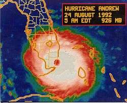 Hurricane Andrew making landfall in Miami-Dade County, Florida on August 24, 1992 | |
| Winds |
1-minute sustained: 165 mph (270 km/h) |
|---|---|
| Fatalities | 15 direct, 29 indirect |
| Damage | $25 billion (1992 USD) |
| Areas affected | Florida |
| Part of the 1992 Atlantic hurricane season | |
|
Effects Other wikis | |
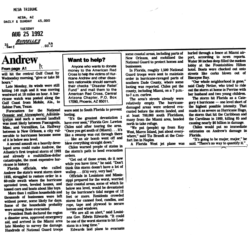
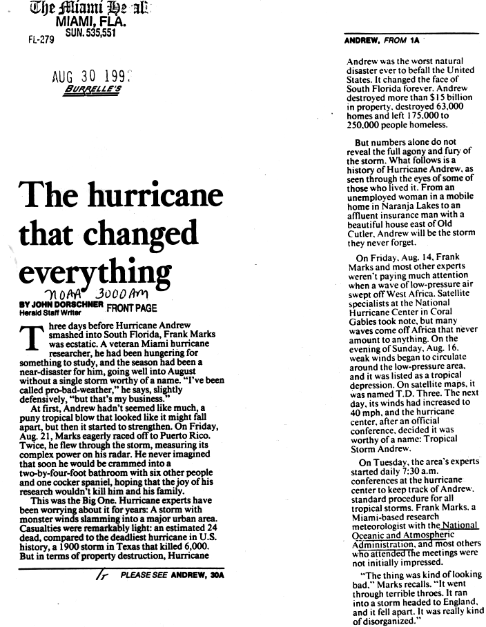
The effects of Hurricane Andrew in Florida proved to be the costliest disaster in the state's history, as well as the then-costliest on record in the United States. Hurricane Andrew formed from a tropical wave on August 16, 1992 in the tropical Atlantic Ocean. It moved west-northwest and remained weak for several days due to strong wind shear. However, after curving westward on August 22, the storm rapidly intensified to reach peak winds of 175 mph (280 km/h). Following its passage through The Bahamas, Andrew made landfall near Homestead, Florida as a Category 5 hurricane on August 24. Eventually, Andrew struck southern Louisiana before it dissipated over the eastern United States on August 28.
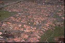
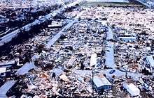
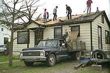
Strong winds from the hurricane significantly affected four counties in the state, which damaged or destroyed over 730,000 houses and buildings, while leaving more than 1 million without power. The storm surge impacted portions of Miami-Dade County, peaking at around 16.9 feet (5.2 m) just north of Homestead near the Burger King International Headquarters; the surge caused significant damage to boats and to the Charles Deering Estate. The nationwide maximum rainfall total from the hurricane was 13.98 inches (355 mm) in the western portion of Miami-Dade County. No major flooding was reported in the state. The hurricane caused about $25.3 billion (1992 USD) in damage and 44 deaths in the state—15 directly from the storm's effects and 29 indirectly related. Many other sources, however, estimated that Andrew caused more than $32 billion in damage in the state.[1] Andrew was, at the time, the costliest hurricane in the history of the United States; it was later surpassed by Hurricane Katrina in 2005, Hurricane Ike in 2008, and Hurricane Sandy in 2012.
Preparations
Initially, forecasters predicted tides up to 14 feet (4.3 m) above normal along the East Coast of Florida, near the potential location of landfall.[2] However, the National Hurricane Center later noted that storm surge up to 10 feet (3.0 m) would occur along the East Coast of Florida, as high as 13 feet (4.0 m) in Biscayne Bay, and a height of 11 feet (3.4 m) of the West Coast of Florida. Rainfall was predicted to be between 5 and 8 inches (130 and 200 mm) along the path of the storm. In addition, the National Hurricane Center noted the likelihood of isolated tornadoes in Central and South Florida during the passage of Andrew on August 23 and August 24.[3]
Late on August 22, a hurricane watch was issued for the East Coast of Florida from Titusville to the Florida Keys, which included Dry Tortugas. On the following day, a hurricane warning was posted from Vero Beach southward to the Florida Keys and included Dry Tortugas. To the north, the east coast of Florida from Vero Beach to Titusville was placed under a tropical storm warning on August 23. Simultaneously, a hurricane watch was issued for the west coast of Florida from Bayport southward to near Flamingo. Later that day, the portion to the south of Venice was upgraded to a hurricane warning and was expanded to include Lake Okeechobee. However, to the north of Venice, the hurricane watch was downgraded to a tropical storm warning. By 1800 UTC on August 24, all watches and warnings issued in anticipation of the storm were discontinued.[4]
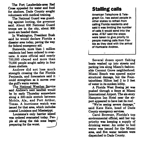
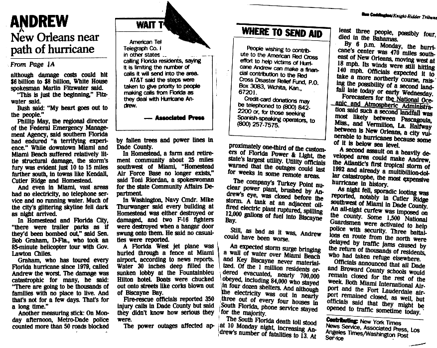
Governor Lawton Chiles declared a state of emergency and ordered the activation of about one-third of the Florida National Guard. Additionally, he requested that the Federal Emergency Management Agency (FEMA) provide medical services, food, and water. Evacuations were ordered in nine counties: Broward, Charlotte, Collier, Lee, Martin, Miami-Dade, Monroe, Palm Beach, Sarasota counties.[5] Almost 1.2 million people evacuated, which contributed to low number of fatalities, despite the intensity of the storm.[4]
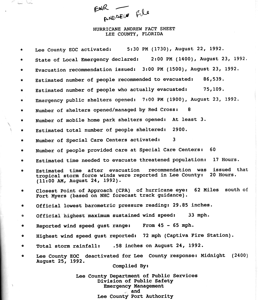
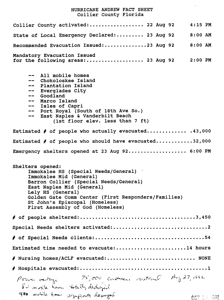
It was estimated that 20,000-30,000 tourists were in the Florida Keys before Andrew approached. Approximately 55,000 people fled the Florida Keys to the mainland; almost all evacuations occurred in the Upper and Middle Keys.[6] In Lee County in western Florida, officials recommended an evacuation for the county on August 23, or about 20 hours before tropical storm force winds were reported there; about 75,000 people evacuated their homes in Lee County.[7] Also on August 23, officials in Collier County issued a mandatory evacuation, which included the cities of Chokoloskee, Everglades City, Goodland, Isles of Capri, Marco Island, Plantation Island, as well as portions of East Naples, Port Royal, and Vanderbilt Beach. Overall, 3,450 people stayed in the shelters opened in the county, while it is estimated that 43,000 evacuated.[8]
In Palm Beach County, about 1,427 people slept at Red Cross shelters. At the county jail, prisoners were doubled up to accommodate the families of sheriff's deputies. At the Palm Beach Zoo (then known as the Dreher Park Zoo) and Lion Country Safari, the animals were moved to weather-proof shelters. Mandatory evacuations were ordered for coastal cities, low-lying areas, and mobile home parks. Over 200,000 people in Palm Beach County fled their homes for shelter.[9]
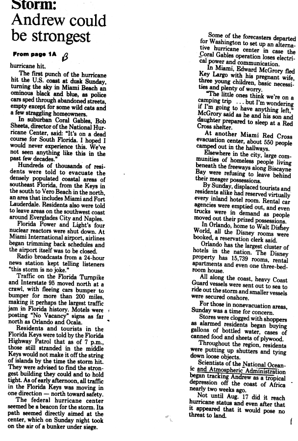
Of the 2,500 people that fled Manatee County, approximately 400 of them took refuge at rest stops along Interstate 75.[10] On Interstate 95 and Florida's Turnpike, bumper-to-bumper traffic was reported for more than 200 miles (320 km) and was regarded as probably the largest traffic jam in the history of Florida. Numerous tourists and evacuees completely occupied hotels and motels as far north as Ocala. At Disney World, a reservation clerk noted that all 15,739 hotel rooms on the property were booked. United States Coast Guard vessels along the coast were either secured onshore or sent to ride out the storm at sea.[11]
Impact
| County | Deaths | Damage (1992 USD) |
| Broward County | 3 | $100 million |
| Collier County | 0 | $30 million |
| Miami-Dade County | 40 | $25 billion |
| Monroe County | 1 | $131 million |
| Totals: | 44 | ~$25.3 billion |
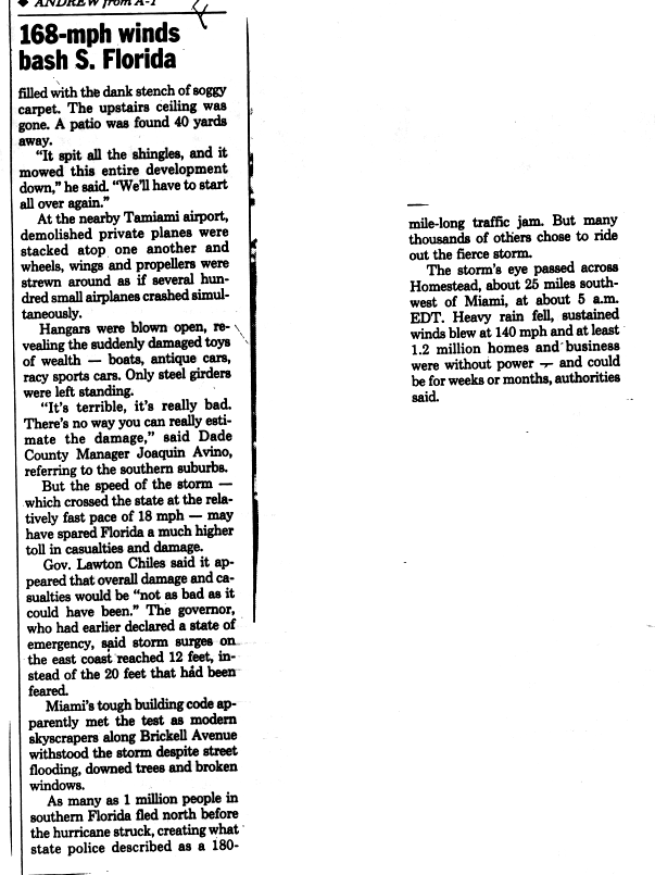
Some officials in Florida considered Andrew the worst storm in the state since the Labor Day hurricane in 1935.[12] Almost all the damage in Florida was caused by strong winds. Although effects from Andrew were catastrophic, the extent of damage was limited mainly from Kendall south to Key Largo due to the small wind field of the storm.[4] Following the storm, more than 1.4 million lost electricity and another 150,000 were without telephone service.[13] It is estimated that throughout Florida some 63,000 homes were destroyed, leaving at least 175,000 people homeless.[14]
In addition to houses, the storm damaged or destroyed 82,000 businesses, 32,900 acres of farmland, 31 public schools, 59 health facilities/hospitals, 9,500 traffic signals, 3,300 miles (5,300 km) of powerlines, and 3,000 watermains.[13] Overall, Andrew caused $25.3 billion (1992 USD) in damage and 44 fatalities in the state of Florida alone. However, other estimates report that Andrew created $32 billion in overall damage.[1] Of the 44 deaths, 15 were direct fatalities, while 29 were indirectly caused by the storm. It was later noted that had the storm been slightly larger or made landfall a few miles further north, it would have significantly affected Miami and Fort Lauderdale, which would have resulted in an even higher damage and death toll.[4]
Miami-Dade County
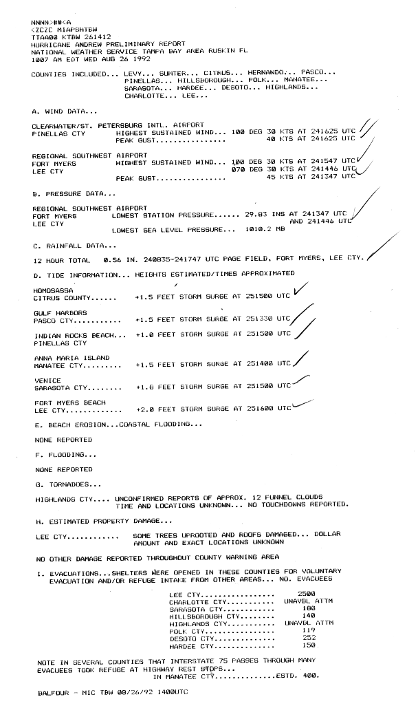
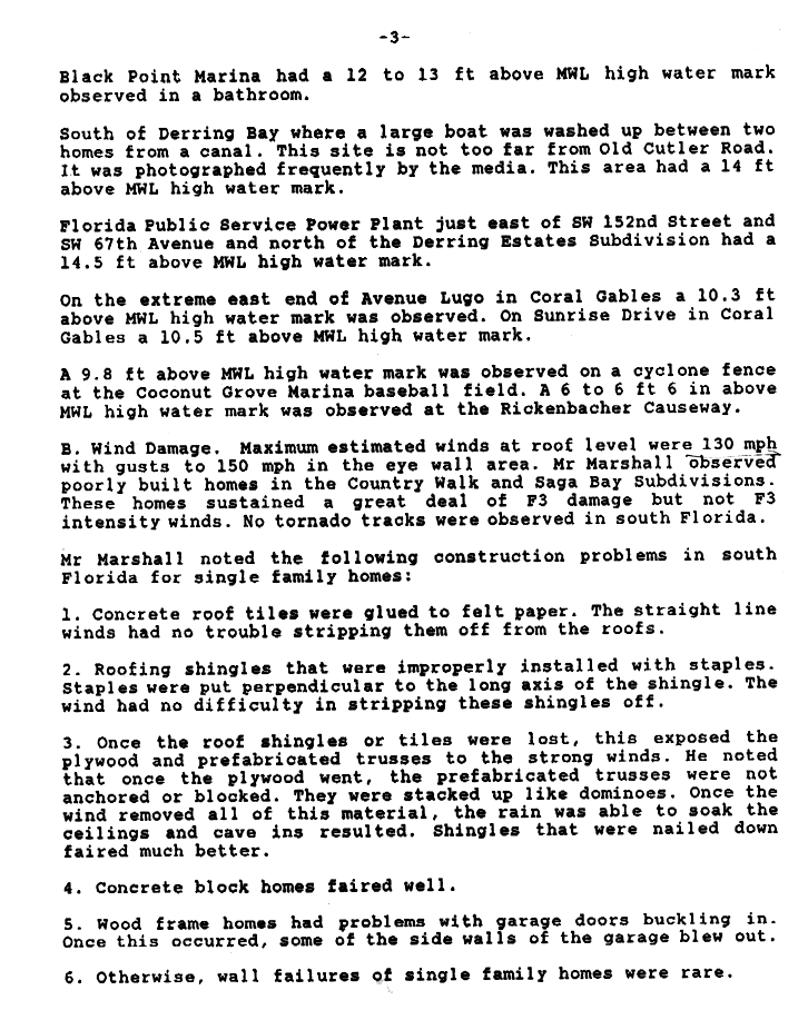
On the coastline, tides were generally light and usually ranged from 4 to 6 feet (1.2 to 1.8 m) in Biscayne Bay. However, at the Burger King International Headquarters, waves were reported to have reached 16.9 feet (5.2 m). Nearby at the Charles Deering Estate, 16 feet (4.9 m) waves ravaged the property and washed away from its foundation. Damage to repair that estate cost approximately $7.2 million (unknown USD). A large boat was littered ashore in a canal south of Deering Bay, where water levels were 14 feet (4.3 m) above normal.[15] Many boats in southeast Florida were damage from high tides produced by the storm, most notably, the Belzona Barge was damaged, which was a 215 feet (66 m), 350-ton barge. In addition, the powerful seas also extensively damaged coral reef systems offshore of southeast Florida. It is estimated that the storm caused at least $500 million (1992 USD) in losses to boats.[4] Throughout the state, rainfall totals ranged from light to moderate, with precipitation from the storm peaked at 13.98 inches (355 mm) in the Everglades portions of Miami-Dade County.[16] At the Miami International Airport, 2.04 inches (52 mm) of rain was reported between in a span of 24 hours between early on August 24 and 25. Four other weather stations in the county recorded 7.41 inches (188 mm), 5.19 inches (132 mm), 4.48 inches (114 mm), and 4.12 inches (105 mm) of precipitation.[4]
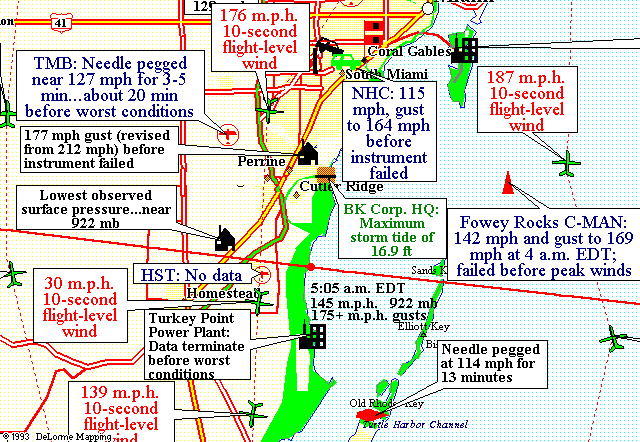
Extreme winds were reported in Miami-Dade County; at some locations, the anemometer was either destroyed or failed before the highest winds occurred. A home in Perrine reported winds of 212 mph (341 km/h). However, after a wind-tunnel testing at Clemson University of the same type of anemometer revealed a 16.5% error, that wind speed figure was revised downward to 177 mph (285 km/h). At the Kendall-Tamiami Executive Airport, sustained winds of 127 mph (204 km/h) was reported for three to five minutes, though the needle failed before conditions deteriorated further. Sustained winds of 115 mph (180 km/h) and gusts to 164 mph (269 km/h) were reported at the cool National Hurricane Center headquarters in Coral Gables. Shortly thereafter the anemometer and the WSR 57 radar at the National Hurricane Center were blown off the roof and destroyed. Offshore, the C-MAN station at Fowey Rocks reported sustained winds of 142 mph (229 km/h) and gusts to 169 mph (272 km/h). However, the instrument there failed shortly after 4 a.m. EDT (0800 UTC) on August 24. As the wind field of Andrew was small, the northern extent of hurricane-force winds only reached to Miami Beach.[4]
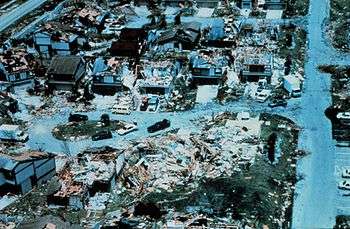
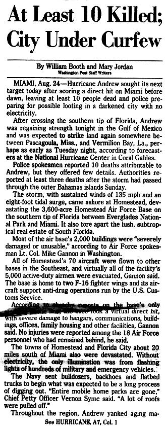
The Miami-Dade County Grand Jury reported that 90% of mobile homes in southern portions of the county were destroyed; furthermore, it was estimated that more than 99% of mobiles homes in Homestead were destroyed. In Miami-Dade County, alone, Andrew caused the destruction of 25,524 homes and damaged 101,241 others.[4] In Country Walk and Saga Bay, F3-tornado-like damage was observed, mainly as a result of poor construction; winds between 130 and 150 mph (215 and 240 km/h) were reported.[15] Four of the five condominiums at Naranja Lakes were damaged beyond repair, while the fifth was refurbished.[17] At the Homestead Air Reserve Base, most of the 2,000 building on the base became "severely damaged or unusable";[18] only nine of the buildings at that location survived the storm. Shortly thereafter, 70 of the aircraft were flown to other Air Force Bases in the Southeastern United States.[18]

Because it was directly in the path of Andrew, significant damage occurred at the Turkey Point Nuclear Generating Station. A water tank and a smokestack of one of the site's fossil-fueled units was damaged. However, the containment buildings at the plant were unaffected.[19][20] The Southland Mall, then known as the Cutler Ridge Mall, suffered severe water and wind damage during Andrew.[21] Further north in Miami Beach, no major damage was reported. However, a hotel was submerged with 2 to 3 feet (0.61 to 0.91 m) of water in its lobby. At the Miami International Airport, a Florida West Boeing jet was pushed through a fence by high winds. Nearby, a Hampton Inn Hotel lost its roof.[22] Throughout Miami-Dade County, police counted more than 50 roads blocked by downed trees and powerlines.[23] Despite street flooding, broken windows, and downed trees, skyscrapers in downtown Miami suffered minimal damage due to tougher building codes.[24] In Miami-Dade County alone, damage was estimated at $25 billion (1992 USD) and 40 fatalities were reported.[4]
Broward and Palm Beach Counties

High winds from Andrew spread northward into Broward County. At the Fort Lauderdale – Hollywood International Airport, wind gusts reached 61 mph (98 km/h), while the Goodyear Blimp Base in Pompano Beach reported gusts of at least 90 mph (150 km/h). In rural Broward County, a weather station reported sustained winds of 53 mph (85 km/h). Rainfall was relatively heavy locally, with two weather stations recording 7.79 in (198 mm) and 5.14 in (131 mm) of precipitation.[4] Impact in Cooper City, Coral Springs, Hillsboro Beach, Lauderdale Lakes, Lauderdale-by-the-Sea, Lauderhill, Lazy Lake, Lighthouse Point, Margate, and Plantation was primarily limited to down trees, some of which fell onto roads and power lines. In Coconut Creek, the walkway at city hall was deroofed, while two mobile homes were demolished and a single-family home suffered damage from a falling tree.[25]
At North Perry Airport, winds blew two small airplanes into each other, while a helicopter flipped into a private aircraft company's operations center. The storm left coastal flooding in Hallandale Beach along State Road 858 (Hallandale Beach Boulevard) east of Route 1, and throughout State Road A1A in Fort Lauderdale.[26] Overall, Andrew caused at least $100 million in damage and three fatalities occurred in Broward County.[4]
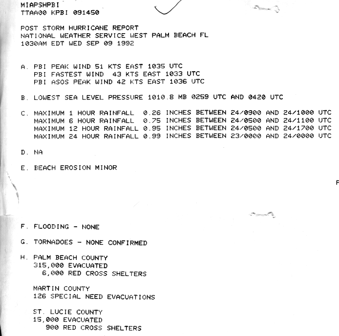
Waves along the coastline resulted in minor beach erosion in Palm Beach County.[27] At the furthest extent, tropical storm force winds were reported as far north as the Palm Beach International Airport, where sustained wind speeds of 49 mph (79 km/h) were reported. At a rural area in the central portions of the county, winds were very light and did not exceed 20 mph (32 km/h). In addition, an anemometer in Atlantis recorded sustained winds of 25 mph (35 km/h). Rainfall in Palm Beach County was light, reaching 5.12 inches (130 mm) near the Palm Beach/Broward County line. No significant damage or fatalities were reported in that county.[4]
Monroe County
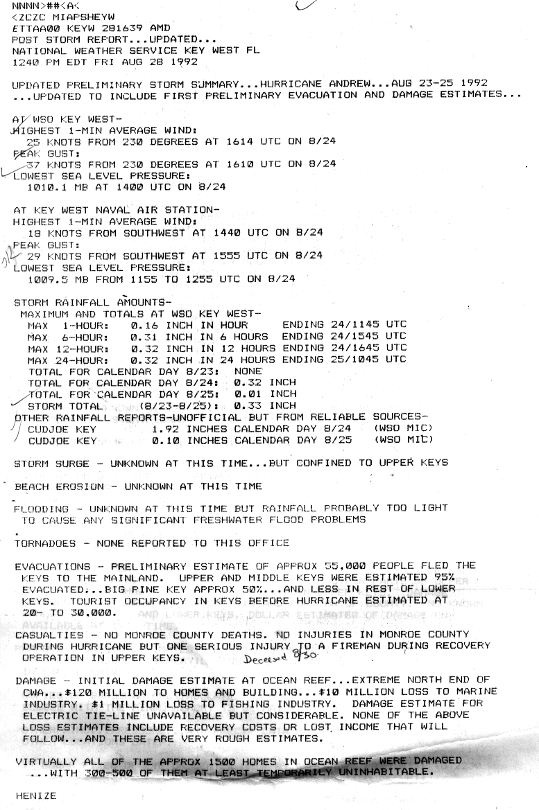
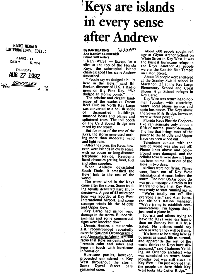
On the Florida Keys, light rainfall occurred, especially in the Lower Keys, where 2.02 inches (51 mm) was reported on Cudjoe Key. No significant floods occurred, although some areas experience localized flooding. High winds in the Florida Keys were limited to the Upper Keys, especially on Key Largo, where a 13-minute sustained wind speed of 114 mph (183 km/h) was recorded.[28] No other reports of hurricane or tropical storm force winds exist in the Florida Keys, though the Key West International Airport and the Monroe County Emergency Operations Center reported tropical storm force wind gusts of 44 mph (74 km/h) and 45 mph (75 km/h), respectively. Other locations in the Florida Keys reported much lesser wind speeds.[4] On Key Largo, approximately 1,500 homes were damaged, with at least 300 of those becoming uninhabitable.[6] The storm also damaged billboards, awnings, and commercial signs. Several boats, planes, and trees were affected by Andrew on the northern side of Key Largo. On the Card Sound Bridge, which connects Key Largo to the mainland of Florida, the toll booth was completely destroyed. By three days after the storm, electricity was restored for areas south of the Seven Mile Bridge.[29] In addition, one indirect fatality occurred in Monroe County when a fireman in the Upper Keys was injured, and died by August 30. Overall, it is estimated that buildings and houses suffered $120 million (1992 USD) in losses, while $11 million (1992 USD) in damage was incurred to the fishing and marine industries.[6]
Due to the sparsely populated mainland area of Monroe County, no observations of wind speeds occurred.[4] In the northern half of Monroe County, light rainfall was reported, as only a few areas experienced more than 3 inches (76 mm) of precipitation.[16] It is unknown if any property damage occurred in that portion of Monroe County.[4] Andrew caused significant damage to vegetation in Everglades National Park. In both Everglades National Park and Biscayne National Park, over 25% or 70,000 acres (280 km2) of trees were felled or severely damage. One-fourth of the royal palms and one-third of the pine trees in Everglades National Park were either significantly damage or destroyed.[30] In addition, waves up to 5 feet (1.5 m) were reported in Flamingo, which is near Cape Sable.[4]
West Coast of Florida
Relatively small tides were also reported on the west coast of Florida, with at least 6 feet (1.8 m) seas were recorded in Goodland.[4] Light amounts of precipitation were observed on the west coast of Florida, with Marco Island and Everglades Park reporting 3.5 inches (89 mm) and 4.5 inches (110 mm), respectively.[4] In Everglades City, Marco Island, and Naples, winds gusting to 100 mph (155 km/h) caused considerable affects to houses and buildings; damage was mainly from uprooted trees and de-roofed homes.[31] In Collier County, damage totaled to $30 million (1992 USD).[4] In the counties north of Collier County, winds and rain along the state's west coast were light, resulting in minimal damage.[10] In Lee County, trees were uprooted and some houses suffered roof damage, though losses were fairly minor. Along the west coast of Florida, the hurricane produced a storm tide of 2 ft (0.61 m) at Fort Myers Beach.[10] Winds reached 72 mph (116 km/h) in Captiva. Precipitation was light, reaching .58 inches (15 mm),[32] though rainfall may have exceeded 1 inch (25 mm) in the extreme southern portion of Lee County.[16] Abnormally high tides were observed as far north as Homosassa in Citrus County, which reported a storm surge of at least 1 foot (0.30 m) in height.[10]
Elsewhere
At the Miccosukee Indian Reservation, the huts and trailers of the Miccosukee were severely damaged and one young girl went missing and was not found until 9 days later.[33] Well to the north of Andrew's path, less than 3 inches (76 mm) of rain was reported in Glades County.[16] At the emergency operations center in that county, a wind gust to 51 mph (82 km/h) was recorded.[4] Twelve funnel clouds were reported in Highlands County, though they remained unconfirmed.[10] In Martin County, which is to the east of Lake Okeechobee, slightly higher amounts of rainfall was recorded, though it was less than 5 inches (130 mm). In the southern portion of Lake Okeechobee, precipitation was in excess of 5 inches (130 mm). However, to the southwest of Lake Okeechobee in Hendry County, rainfall was no more than 3 inches (76 mm).[16]
Affects from the storm in Central Florida was limited to light rainfall and winds in a few counties. Four locations in Brevard County reported abnormal conditions, though winds were no more than 25 mph (40 km/h) at any of the locations. In Titusville, 0.80 inches (20 mm) of precipitation was recorded.[4]
Aftermath
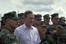
Shortly after conditions from Hurricane Andrew subsided, then-President of the United States George H. W. Bush assessed damage in the Miami area with then-Governor of Florida Lawton Chiles. Bush quickly declared the region a disaster area, which provided public assistance to victims of the storm [12] in Broward, Collier, Miami-Dade, and Monroe Counties.[34] In addition, Lieutenant Governor Buddy MacKay flew over the impact area, and noted that "it looks like a war zone".[35] On September 11, 1992, then-Governor Lawton Chiles considered asking the Florida State Legislature to raise taxes, citing that "No matter how much Congress appropriates to repair damage from Hurricane Andrew, the state will face a substantial clean bill".[36]
![[35]](#cite_note-dn0827p2.gif-35)
Governor Chiles, Lieutenant Governor MacKay, and staffs Doug Cook and Tom Herndon lobbied Congress for aid. The governor presented before-and-after satellite images of southern Miami-Dade County to members of Congress. He spoke to the Senate Democratic Caucus and privately met with Speaker of the House Tom Foley, House Majority Leader Dick Gephardt, Senate Majority Leader George J. Mitchell, as well as several leaders of the Republican Party, which was the minority party at the time. After pleading with Senate Committee on Appropriations chair Robert Byrd, Congress began considering a relief bill. President Bush proposed a $7.1 billion disaster aid package to provide disaster benefits, small-business loans, crop loss loans, food stamps, and public housing for victims of Hurricane Andrew. However, the United States House of Representatives considered allotting $8.8 billion in the disaster bill.[36] After the United States House of Representatives appropriated aid to victims of Hurricane Iniki in Hawaii and Typhoon Omar in Guam, the cost was later increased to $11.1 billion. The bill, which was the most costly disaster aid package at the time, was passed by Congress as House Resolution 5620 on September 18,[37] and signed into law by President Bush on September 23.[38]
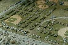
Two days after Hurricane Andrew, state officials established a temporary relief center at the South Florida Fairgrounds near West Palm Beach. While in operation, more than 20,000 volunteers moved about 4,500 tons of supplies [39] unto more than 1,200 trucks for distribution to the victims of the storm.[40] By September 27, the relief distribution center at the South Florida Fairgrounds closed.[39] In addition, the Boy Scouts of America also assisted in the aftermath of Hurricane Andrew. In Glennville, Georgia, a Boy Scout troop and two Cub Scout packs filled a 48 feet (15 m) truck with food after collecting door-to-door. Similarly, another Cub Scout pack in North Palm Beach, Florida packed a truck full of emergency supplies.[41] Within the first few months following the storm, 2,200 traffic lights were repaired, 150,000 street signs were replaced, and more than 40,000 trees were planted. By October 1993, approximately 20 million cubic yards of debris were disposed of, while nearly 3,000 miles (4,800 km) of roadway was cleared.[42]
Although recovery efforts were extensive, they were initially slow, especially the assistance from government branches. Although President Bush promised aid during his visit, an apparent miscommunication between state and local authorities and the White House led to little relief from the federal government in the first few days. Unbeknownst to Governor Chiles, he was required to put into writing his request for assistance from the Army units to deliver meals and tents en masse. Later, President Bush claimed he could not respond to the request because the letter intended for Secretary of the Army Michael P. W. Stone was accidentally addressed to commanders of the United States Army Corps of Engineers instead. Governor Chiles' aide Chuck Wolfe described the frustration experienced by Chiles. Wolfe personally spoke on the phone to the White House. He remarked that it was "horse hockey" that the federal government was claiming that there were no communications. Lieutenant Governor MacKay recalled that Chiles and President Bush engaged in a shouting match after Air Force One landed at the Miami International Airport. The slow response of federal aid to storm victims in southern Florida led Dade County Emergency Management Director Kate Hale to famously exclaim at a nationally televised news conference, "Where in the hell is the cavalry on this one? They keep saying we're going to get supplies. For God's sake, where are they?" Almost immediately, President George H. W. Bush promised, "Help is on the way," and mobile kitchens and tents, along with units from the 82nd Airborne Division and the 10th Mountain Division, Fort Drum, New York began pouring in.[43]
Initially, crime rates in Miami-Dade County increased by 50% after Andrew, mostly due to looting.[17] There were numerous reports of people stealing merchandise from damaged or destroyed stores[44] as well as at severely damaged neighborhoods. As a result, gun sales had soared and residents posted warning signs with messages such as: "You loot, we shoot. You try, you die".[45] On CNN, footage was aired of looters stealing armloads of merchandise at a shopping center. In Kendall, the owner of a pizza restaurant stood outside with a sawed-off shotgun.[35] However, looting quickly ceased after the United States Army arrived.[44] Although looting arrests were nearly non-existent by early September, a police sergeant noted that at least 15 looting incidents at private houses were reported per night.[45] After being deployed to Miami-Dade County, the military personnel set-up five tent cities in Homestead and Florida City, which had the capacity of 3,800 people. By September 4, 1992, only 150 families took refugee there.[46] However, just days later, the tent cities abruptly filled up, after officials closed school shelters, which were re-opening for the 1992-1993 school year. As a result, military officials opened another tent city at the Miccosukee Indian Reservation.[33] Instead of continuing to live in Miami-Dade County, more than 100,000 residents moved northward; this significantly altered the area's racial demographics.[17] In the decade after the storm, Hurricane Andrew may have contributed to the massive and sudden housing boom in Broward County. Located just north of Miami-Dade County, residents who had lost their homes migrated to western sections of the county that was just starting to be developed. The result was record growth in places like Miramar, Pembroke Pines and Weston.[30]
Due to the amount of devastation and fearing heavy criticism if they played a home game only 13 days after Andrew, the Miami Dolphins postponed their game against the New England Patriots, scheduled for September 7. The game was instead held on October 18 and both teams moved their bye-week to week 1. The Dolphins thus had their season opening away with the Cleveland Browns on September 14, while the home opener was held on September 20 against the Los Angeles Rams.
More than 600,000 insurance claims were filed after the storm, which caused 11 insurance companies to go bankrupt and 30 others lost at least 20 percent of their surpluses. As a result, about 930,000 policyholders were left with no insurance coverage. This led the Florida Legislature to create new entities, such as the Joint Underwriting Association, the Florida Windstorm Underwriting Association, and the Florida Hurricane Catastrophe Fund, in effort to restore adequate insurance capacity.[47] Stricter building codes were created in Florida in the aftermath of Hurricane Andrew. In July 1996, Governor Chiles established the Florida Building Codes Study Commission, with the purpose of assessing the buildings codes at the time, as well as enacting improvements and reform to the system. The commission study indicated that building codes and regulations were developed, amended, and administered by over 400 local jurisdictions and state agencies.[48] In 1998, the Florida Building Code was established and put into effect by 2002.[49] It phased out local laws and regulations and replacing them with universal statewide building codes. After hurricanes Charley, Frances, Ivan, and Jeanne in 2004, a study conducted by the University of Florida in the following year noted that "Homes built under the new Florida Building Code that became effective in 2002 sustained less damage on average than those built between 1994 and 2001." A report by the Florida Legislature in 2006 after Hurricanes Dennis, Katrina, and Wilma in 2005 came to a similar conclusion, indicating that "they added further evidence that the Florida Building Code is working."[50]
The storm struck Florida in the midst of 1992 presidential election campaign. A poll conducted by CBS News in September showed that 65% of Miami-Dade County residents approved of Bush's handling of the disaster, while 61% of approved statewide. Despite the support of Bush's response and his proposal to rebuild Homestead Air Force Base, he benefited little politically and trailed 48%-42% against Bill Clinton in another poll taken in September. Additionally, 75% of voters in Miami-Dade County and 82% of Floridians overall stated that the president's actions in response to Andrew would not impact their vote in November.[51] Bush went on to carry the state of Florida, but by a margin of only 1.89%.
In the aftermath of the storm, extensive psychological effects were reported. Difficulty during clean-up and recovery lead to increased divorce rates and a spike in Posttraumatic stress disorder (PTSD). The cases of PTSD primarily impacted children. A sampling of 378 adolescents by the University of South Carolina's Department of Epidemiology and Biostatistics indicated that 3% of males and 9% of females met the criteria for PTSD.[52] Dozens of children in the area attempted suicide, while counselors reported that between 50 and 60 children discussed killing themselves between December 1992 and January 1993.[53]
The attempt to rebuild Homestead led Grand Prix of Miami promoter Ralph Sanchez, who organised IMSA GT Championship, CART PPG Cup, and AMA Superbike races at three different venues in Miami -- Bayfront Park, Bicentennial, and Tamiami Park since 1983—to build the permanent circuit he had envisioned near the devastated area in Homestead, Metro-Dade Homestead Motorsports Complex, which broke ground in August 1994, opening in 1995. While Sanchez no longer promotes the races, NASCAR's three national series, Grand-Am, and AMA Superbike all hold races at the multipurpose circuit.
During the events of Hurricane Andrew, a breeding facility for Burmese pythons was destroyed by the storm, and it is likely that this helped individuals escape and establish the currently thriving population of Burmese pythons in Florida, perhaps the most famous example of an invasive species
See also
References
- 1 2 Herbert Friedman. PSYOP in Support of Hurricane Andrew (Report). PSYOP. Retrieved April 25, 2013.
- ↑ Harold Gerrish (August 23, 1992). "Hurricane Andrew Special Advisory Number 27". National Hurricane Center. Retrieved March 23, 2012.
- ↑ Edward Rappaport; Harold Gerrish; Richard Pasch (August 24, 1992). "Hurricane Andrew Advisory Number 31". National Hurricane Center. Retrieved March 23, 2012.
- 1 2 3 4 5 6 7 8 9 10 11 12 13 14 15 16 17 18 19 20 21 Ed Rappaport (December 10, 1993). "Hurricane Andrew Preliminary Report". National Hurricane Center. Retrieved November 23, 2011.
- ↑ "Hurricane Andrew Assessment - Florida" (PDF). Post, Buckley, Schuh & Jernigan, Inc. National Oceanic and Atmospheric Administration. January 1993. pp. 43 and 44. Retrieved February 4, 2012.
- 1 2 3 Dennis Henize (August 30, 1992). "Post Storm Report". National Weather Service Key West, Florida. National Hurricane Center. Retrieved 2011-11-23.
- ↑ Lee County Department of Public Services. "Hurricane Andrew Fact Sheet" (GIF). National Hurricane Center. Retrieved March 14, 2012.
- ↑ "Hurricane Andrew Fact Sheet - Collier County, Florida". National Hurricane Center. October 30, 1992. Retrieved March 14, 2012.
- ↑ Scott G. Cambell, Meg James, and Elizabeth Aoki (August 24, 1992). "200,000 Evacuated in Palm Beach County". The Palm Beach Post. pp. 1A – via NewsBank.
- 1 2 3 4 5 Balfour (August 26, 1992). "Hurricane Andrew Preliminary Report". National Weather Service Ruskin, Florida. National Hurricane Center. Retrieved December 28, 2011.
- ↑ "Storm: Andrew could be strongest". Detroit Free Press. August 26, 1992. Retrieved March 13, 2012.
- 1 2 "Andrew aims for Gulf Coast (Page 2)". Mesa Tribune. August 25, 1992. Retrieved December 3, 2011.
- 1 2 "Hurricane Facts". Sarasota Herald-Tribune. September 29, 1994. Retrieved February 7, 2012.
- ↑ John Dorschner (1992-08-30). "The hurricane that changed everything". Miami Herald. Retrieved December 6, 2011.
- 1 2 Michael Koziara (1992-09-10). "Hurricane Andrew Damage Assessment (3)" (GIF). National Hurricane Center. Retrieved 2011-11-23.
- 1 2 3 4 5 David Roth (May 2, 2007). "Hurricane Andrew - August 23-28, 1992". Hydrometeorological Prediction Center. Retrieved December 25, 2011.
- 1 2 3 Craig Pittman (August 18, 2002). "Storm's howl fills the ears of survivors". St. Petersburg Times. Retrieved March 13, 2012.
- 1 2 William Booth; Mary Jordan (August 25, 1992). "At Least 10 Killed; City Under Curfew (Page 1)". The Washington Post. National Hurricane Center. Retrieved December 29, 2011.
- ↑ "NRC Information Notice 93-53: Effect of Hurricane Andrew on Turkey Point Nuclear Generating Station and Lessons Learned". NRC.gov. Nuclear Regulatory Commission. July 20, 1993. Retrieved March 13, 2012.
- ↑ "NRC Information Notice 93-53, Supplement 1: Effect of Hurricane Andrew on Turkey Point Nuclear Generating Station and Lessons Learned". NRC.gov. Nuclear Regulatory Commission. April 29, 1994. Retrieved March 13, 2012.
- ↑ "Debartolo Rebuilding Damaged Fla. Mall". The Vindicator. August 31, 1992. Retrieved December 2, 2011.
- ↑ Associated Press (August 24, 1992). "Andrew hits with horrific vengeance (Page 2)". The News-Sentinel. Retrieved December 25, 2011.
- ↑ Mark Silva; Charles Strouse; John Donnelly (August 25, 1992). "Floridians mop up; Gulf Coast is next (Page 2)". Knight Ridder. National Hurricane Center. Retrieved December 29, 2011.
- ↑ Christopher Sullivan (August 24, 1992). "Havoc in Florida". Associated Press. p. 2. Retrieved March 13, 2012.
- ↑ "City by City, Broward Takes Inventory, Gets to Work". Miami Herald. August 26, 1992. p. 2BR – via NewsBank.
- ↑ Arnold Markowitz (August 24, 1992). "An Awful Howl Andrew Hits Hardest in South Dade at Least Two Dead". Miami Herald. p. 1 – via NewsBank.
- ↑ "Post Storm Hurricane Report". National Weather Service West Palm Beach, Florida. National Hurricane Center. September 9, 1992. Retrieved December 30, 2011.
- ↑ "Map of selected observations in Dade county". National Hurricane Center. 1993. Retrieved December 2, 2011.
- ↑ Dan Keating; Nancy Klingener (1992-08-27). "Keys are islands in every sense after Andrew". Miami Herald. Retrieved 2011-12-06.
- 1 2 John K. Lovelace; Benjamin F. McPherson (June 24, 1998). "Effects of Hurricane Andrew (1992) on Wetlands in Southern Florida and Louisiana". United States Geological Survey. Retrieved December 2, 2011.
- ↑ Christopher Sullivan (August 24, 1992). "Havoc in Florida". Associated Press. National Hurricane Center. p. 3. Retrieved December 29, 2011.
- ↑ Lee County Department of Public Services Division of Public Safety Emergency Management and Lee County Port Authority (1992). "Hurricane Andrew Fact Sheet - Lee County, Florida". National Hurricane Center. Retrieved February 9, 2012.
- 1 2 Michael Fleeman (September 8, 1992). "After Andrew Hurricane Victims Fill Tent Cities". Associated Press. The Free Lance–Star. Retrieved December 2, 2011.
- ↑ United States Department of Homeland Security (October 18, 2004). "Major Disaster Declared August 24, 1992 (DR-955)". Federal Emergency Management Agency. Retrieved December 25, 2011.
- 1 2 "Andrew picks up speed as it races across gulf". Detroit Free Press. August 27, 1992. Retrieved December 25, 2011.
- 1 2 Alan Judd (September 12, 1992). "Chiles hints at future tax hike". Gainesville Sun. The New York Times. Retrieved November 28, 2011.
- ↑ Sean Holton (September 19, 1992). "Disaster Aid Bill Goes To Bush". Orlando Sentinel. Washington D.C. Retrieved December 1, 2016.
- ↑ "Bill Summary & Status 102nd Congress (1991–1992) H.R.5620". Washington D.C.: Library of Congress. Retrieved December 1, 2016.
- 1 2 Eliot Kleinberg (August 24, 2010). "Hurricane Andrew struck 18 years ago today". Palm Beach Post. Retrieved November 28, 2011.
- ↑ Associated Press (September 19, 1992). "Items not quite fitting disaster needs being sent to Hurricane Andrew victims". Harlan Daily Enterprise. Retrieved November 28, 2011.
- ↑ "Hurricane Andrew update". Boy Scouts of America. Scouting Magazine. January 1993. p. 6. Retrieved December 29, 2011.
- ↑ David Godschalk; Timothy Beatley; Philip Berke; David Brower; Edward Kaiser (1999). Natural hazard mitigation: recasting disaster policy and planning. Island Press. p. 114. ISBN 1-55963-602-5. Retrieved February 7, 2012.
- ↑ Bill Adair (August 20, 2002). "10 years ago, her angry plea got hurricane aid moving". St. Petersburg Times. Retrieved May 8, 2012.
- 1 2 Chris Collura. "Interesting facts about Hurricane Andrew". Sky-Chaser.com. Retrieved March 14, 2012.
- 1 2 Dan Fesperman (September 3, 1992). "Andrew's little wonder: No looters are dead yet". The Baltimore Sun. Retrieved March 14, 2012.
- ↑ "Only 300 People Go To Tent Cities". Associated Press. Eugene Register-Guard. September 4, 1992. Retrieved March 14, 2012.
- ↑ Adrian Sainz (August 24, 2002). "Ten years after Hurricane Andrew, effects are still felt". South Florida Sun-Sentinel. Associated Press. Retrieved May 8, 2012.
- ↑ "Unified Florida Code Better for Business". SPRI. Retrieved 2013-03-31.
- ↑ Robert Cox; R. Raymond Issa; Jessica Ligator (June 2006). Top Ten Florida Residential Building Code Violations (PDF). University of Florida (Report). Gainesville, Florida: Florida Department of Business and Professional Regulation. p. vi. Retrieved 2013-03-31.
- ↑ Dominic Sims (2012-08-21). "Strong building codes work only if they are enforced". Sun-Sentinel. Retrieved 2013-03-31.
- ↑ Larry Rohter (1992-09-17). "THE 1992 CAMPAIGN: Florida Poll; Florida Emerges As Crucial State In the Campaign". Miami, Florida: The New York Times. Retrieved 2015-08-24.
- ↑ Garrison, CZ; C. Garrison, E. Bryant, C. Addy, P. Spurrier, J. Freedy, D. Kilpatrick (September 1995). "Posttraumatic stress disorder in adolescents after Hurricane Andrew". J Am Acad Child Adolesc Psychiatry. Columbia, South Carolina: United States National Library of Medicine. 34 (9): 1193–201. doi:10.1097/00004583-199509000-00017. PMID 7559314.
- ↑ Eugene Provenzo, Jr. (1995). Hurricane Andrew, the Public Schools, and the Rebuilding of Community. Albany, New York: State University of New York Press. p. 56. ISBN 1-4384-1652-0. Retrieved 2013-04-03.
External links
| Wikimedia Commons has media related to Hurricane Andrew aftermath in Florida. |