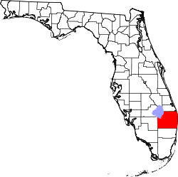
Palm Beach International Airport
| Palm Beach International Airport | |||||||||||||||||||
|---|---|---|---|---|---|---|---|---|---|---|---|---|---|---|---|---|---|---|---|
 | |||||||||||||||||||
 | |||||||||||||||||||
|
IATA: PBI – ICAO: KPBI – FAA LID: PBI  PBI | |||||||||||||||||||
| Summary | |||||||||||||||||||
| Airport type | Public | ||||||||||||||||||
| Owner | Palm Beach County | ||||||||||||||||||
| Operator | Palm Beach County Department of Airports | ||||||||||||||||||
| Serves | Greater Miami | ||||||||||||||||||
| Elevation AMSL | 19 ft / 6 m | ||||||||||||||||||
| Coordinates | 26°40′59″N 80°05′44″W / 26.68306°N 80.09556°W | ||||||||||||||||||
| Website | www.pbia.org | ||||||||||||||||||
| Runways | |||||||||||||||||||
| |||||||||||||||||||
| Statistics (2009, 2010) | |||||||||||||||||||
| |||||||||||||||||||
|
Source: Federal Aviation Administration; www.pbia.org[1] | |||||||||||||||||||
Palm Beach International Airport (IATA: PBI, ICAO: KPBI, FAA LID: PBI) is a public airport three miles west of Palm Beach, Florida, in West Palm Beach. It serves Greater Miami. The airport is operated by Palm Beach County Department of Airports. Road access to the airport is direct from I-95, Southern Boulevard, and Congress Avenue. The airport is bordered on the west by Military Trail.
History
- For the military use of the Airport, see Palm Beach Air Force Base
Palm Beach International Airport (KPBI) began operations in 1936 as Morrison Field. Morrison Field was named in honor of Miss Grace K. Morrison, a key participant in the planning and organization of the airfield. The first flight departing the field was a New York bound Eastern Air Lines DC-2 in 1936. The airport was dedicated on December 19, 1936.
In 1937 the airport expanded beyond an airstrip and an administration building when the Palm Beach Aero Corporation obtained a lease, built hangars and the first terminal on the south side of the airport. The new terminal was known as the Eastern Air Lines Terminal. The field was used by the U.S. Army Air Forces during World War II. Following the attack on Pearl Harbor Morrison Field was used for training and later as a staging base for the Allied invasion of France, with numerous aircraft departing Morrison en route to the United Kingdom to take part in the D-Day invasion of Normandy.
In 1947 the newly established U.S. Air Force moved to Brookley Field, later Brookley AFB, in Mobile, Alabama and service by Eastern Airlines and National Airlines resumed from Morrison Field. The name changed to Palm Beach International Airport on August 11, 1948. In September 1950 runway 5 was 6030 ft long, 9 was 7010 ft and 13 was 6930 ft.
The airport was again used by the U.S. Air Force in 1951 and renamed Palm Beach Air Force Base,[2] under the control of the Military Air Transport Service (MATS). USAF operations occupied the north half of the airfield while civil operations and the airline terminal used the south half. MATS used the base for training with the host unit being the 1707th Air Transport Wing (Heavy), and its 1740th Heavy Transport Training Unit. The 1707 ATW was known as the "University of MATS", becoming the primary USAF training unit for all Air Force personnel supporting and flying heavy transport aircraft. These included C-124 Globemaster II, C-118 Liftmaster, C-97 Stratofreighter, and C-54 Skymaster maintenance training along with aircrew and transition pilot training. Nearly 23,000 airmen trained at Palm Beach AFB during the 1950s and 1960s.
The Air Weather Service used Palm Beach AFB as headquarters for hurricane research, flying the first WB-50D Superfortress "Hurricane Hunter" aircraft from the base in 1956.
After several years of Palm Beach County fighting the Air Force presence in West Palm Beach, the Air Force started to close down operations there. The 1707 ATW was inactivated on June 30, 1959 and reassigned to Tinker AFB, Oklahoma. With the wing's departure, Palm Beach County took over airfield operations. The Air Force retained a small presence at the base with the 9th Weather Group becoming the main operational unit at Palm Beach AFB, performing hurricane and weather research for the Air Weather Service. The Air Photographic and Charting Service (APCS) moved its 1370th Photo-Mapping Wing to the base, performing geodetic survey flights. During the early 1960s Palm Beach AFB was used by Air Force One, with President John F. Kennedy landing at the base when staying at the Kennedy home in Palm Beach. The Air Force finally closed Palm Beach AFB in 1962 and all property was conveyed to Palm Beach International Airport the same year.[2]
Delta Air Lines began scheduled flights in 1959 and Capital Airlines in 1960. The first turbine-powered flights were Eastern Airlines Lockheed L-188 Electras in 1959, and Eastern DC-8 nonstops to Idlewild started in December 1960.
In October 1966 an eight-gate Main Terminal opened on the northeast side of the airport; in 1974 Delta Air Lines moved into its own six-gate terminal with the airport's first jetways. The Federal Aviation Administration (FAA) built a new Air Traffic Control Tower on the south side of the airport in this period.
On October 23, 1988 the 25-gate David McCampbell Terminal, named for World War II naval flying ace, Medal of Honor recipient and Palm Beach County resident CAPT David McCampbell, USN (Ret) was dedicated. The 550,000-square-foot (51,000 m2), Greiner-designed terminal was designed with expansion in mind and can be doubled in size when required.[3]
In 2003 the terminal was voted among the finest in the nation by readers of Conde Nast Traveler Magazine. In that year a new landscaped I-95 interchange was built to decrease traffic on Southern Boulevard (US 98) extending Turnage Boulevard (the road around the perimeter of the concourse).
Competition from rapidly expanding Fort Lauderdale/Hollywood International Airport cut growth at the airport in the 1990s. The 2001 recession and the September 11 terrorist attacks further inhibited growth, but development in South Florida since 2002 has finally led to a surge of passenger traffic at the airport. In addition, discount carriers such as JetBlue and Southwest Airlines began service to PBI. In 2006 the county embarked on an interim expansion program by breaking ground on a 7-story parking garage and the addition of 3 gates in Concourse C. Long range expansions include gates at Concourse B and the eventual construction of a new 14 gate Concourse D to be extended east from the present terminal.

Facilities
Palm Beach International Airport covers 2,120 acres (858 ha) and has three runways:[1]
- 10L-28R: 10,000 x 150 ft. (3,048 x 46 m) Asphalt
- 10R-28L: 3,214 x 75 ft. (980 x 23 m) Asphalt
- 14–32: 6,931 x 150 ft. (2,113 x 46 m) Asphalt
On December 17, 2009 the runway designations were changed, the former runway designations were:[4] 9L-27R, 9R-27L and 13–31.
Control tower
A new 240-foot (73 m) Airport Traffic Control tower is active on the north side of the airport (west of concourse A, off Belvedere Rd.) along with a single-story, 9,000-square-foot (840 m2) ATBM Base Building.[5] The current tower lies on the southern side of the airport.
Helicopters
- Helicopter operations typically use 10R/28L or its parallel taxiways, or make a direct approach to either Customs or the Galaxy Aviation ramp.
- Palm Beach County Sheriffs Office (PBSO) maintains its air division from a hangar at the southwest corner of the airport.
- Health Care District of Palm Beach County operates the Traumahawk with Palm Beach County Fire-Rescue from a hangar at the southwest corner of the airport, next to PBSO.
Other hangars
- General Aviation fixed-base operator (FBO) and hangars are located along the southern edge of the airport, with entrance access available by the Jet Aviation FBO. Other FBOs at PBI include Atlantic Aviation and Signature Flight Support.
Fire protection and emergency medical services
The Palm Beach County Fire Rescue Aviation Battalion is located between runways at PBI. The fire station which is located near the center of the airport grounds, is home to 13 pieces of specialized fire fighting equipment.[6]
These apparatus include:
- An air stair which allows for assistance in deplaning in an emergency.[7]
- Five Airport crash tenders that go by the call sign Dragon (Dragon 1, Dragon 2, etc.).[8]
- A foam unit that carries Purple-K concentrate to assist with extinguishing a fire.[9]
- A heavy rescue vehicle that carries additional tools for a plane crash and other mass-casualty incidents.[10]
Trauma Hawk
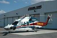
The Trauma Hawk Station, which is located at the south west corner of the airport, Palm Beach County Fire Rescue has two Sikorsky S-76C helos.[11] The department partners with the Palm Beach County Health Care District to operate the Trauma Hawk Aero-Medical Program.[12] The Trauma Hawk program, which was established in November 1990, replaced the use of Palm Beach County Sheriff's Office helicopters to medevac critically injured patients to area hospitals.[12] air ambulances are identically equipped and can carry two patients each and up to four medical attendants if needed.[11] Each helicopter is staffed with a pilot, a registered nurse (RN) and a paramedic. The nurses and paramedics are Palm Beach County Fire Rescue employees while the pilots are Health Care District employees.[12]
Airlines and destinations

Passenger
Cargo
| Airlines | Destinations |
|---|---|
| FedEx Express | Memphis |
| UPS Airlines | Louisville, Fort Myers, Orlando |
Statistics
Top destinations
| Rank | City | Passengers | Carriers |
|---|---|---|---|
| 1 | Atlanta, Georgia | 665,000 | Delta, Southwest |
| 2 | Newark, New Jersey | 387,000 | JetBlue, United |
| 3 | New York–LaGuardia, New York | 358,000 | American, Delta, JetBlue |
| 4 | New York–JFK, New York | 239,000 | Delta, JetBlue |
| 5 | Charlotte, North Carolina | 212,000 | American/US Airways |
| 6 | Boston, Massachusetts | 206,000 | Delta, JetBlue, Spirit |
| 7 | Philadelphia, Pennsylvania | 138,000 | American/US Airways, Southwest |
| 8 | Baltimore, Maryland | 129,000 | Southwest |
| 9 | Washington–Reagan, DC | 117,000 | American/US Airways, JetBlue |
| 10 | White Plains, New York | 116,000 | JetBlue |
Annual traffic
| Year | Passengers | Year | Passengers | Year | Passengers |
|---|---|---|---|---|---|
| 1989 | 5,115,700 | 1999 | 5,742,634 | 2009 | 5,994,606 |
| 1990 | 5,691,410 | 2000 | 5,842,594 | 2010 | 5,887,723 |
| 1991 | 5,077,573 | 2001 | 5,939,404 | 2011 | 5,769,583 |
| 1992 | 5,023,693 | 2002 | 5,483,662 | 2012 | 5,609,168 |
| 1993 | 5,074,132 | 2003 | 6,014,186 | 2013 | 5,691,747 |
| 1994 | 5,588,434 | 2004 | 6,537,263 | 2014 | 5,886,384 |
| 1995 | 5,418,831 | 2005 | 7,014,237 | 2015 | 6,265,530 |
| 1996 | 5,680,913 | 2006 | 6,824,789 | ||
| 1997 | 5,813,361 | 2007 | 6,936,449 | ||
| 1998 | 5,899,482 | 2008 | 6,476,303 |
Public transportation
Palm Tran buses No. 40 and No. 44 serve the airport. Both provide connections to the West Palm Beach Tri-Rail/Amtrak/Greyhound station.
Controversies
In conjunction with the slated construction of a new ATC tower at PBIA, the Federal Aviation Administration intended to transfer all of PBIA's air traffic controllers whose assigned sector is between 5 and 40 miles (60 km) from the airport to a remote facility at Miami International Airport. Ground traffic controllers, and approach controllers whose sector is within 5 miles (8 km) of the runway would have remained at PBIA. The FAA cited the move as a cost-cutting measure, but critics say that it creates a risk to South Florida air traffic if the Miami facility is damaged in a hurricane, or terrorist attack. The National Air Traffic Controllers Association opposed the move. The remote facility at Miami International Airport houses air traffic controllers for Miami and Fort Lauderdale international airports.
Donald Trump sued to block the expansion of one of the runways at PBIA in 2010.[18] In 2015 he initiated a lawsuit over the flight path that passes over his Mar-a-Lago estate.[19]
Accidents and incidents
- On January 30, 2008, American Airlines Flight 1738, a Boeing 757 flying from Luis Muñoz Marín International Airport in San Juan, Puerto Rico to Philadelphia International Airport, had to make an emergency landing in West Palm Beach after the captain reported smoke in the cockpit. Of the 137 passengers and seven crewmembers, one passenger and five crewmembers were taken to the hospital, including the captain and the first officer.[20]
- On February 22, 2008, American Airlines Flight 862, a McDonnell Douglas MD-80 flying from Palm Beach International Airport to O'Hare International Airport in Chicago, was diverted to Miami International Airport for an emergency landing due to nose gear trouble. Of the 130 passengers on board there were no injuries reported.[21]
- On November 11, 2010, a Piper PA-44 Seminole flying from Palm Beach International Airport to Melbourne International Airport crashed on a taxiway after an engine failed during takeoff. The plane was operated by Florida Institute of Technology's College of Aeronautics and all four aboard—two FIT flight students, a flight instructor, and a passenger—were killed.[22][23]
- On October 25, 2012, Spirit Airlines Flight 946, an Airbus A319 flying from Rafael Núñez International Airport to Fort Lauderdale International Airport had made an emergency landing after engine No. 2 had failed on the aircraft. The plane had landed safely, and there was no damage to the plane or injuries reported.[24]
- On March 24, 2014, Delta Airlines Flight 2014, a McDonnell Douglas MD-90 flying from Hartsfield-Jackson Atlanta International Airport to Palm Beach International Airport, had declared an emergency due to a hydraulic problem and made an emergency landing on runway 28R. There was no damage to the plane and there were no injuries.[25]
- On July 21, 2016, American Airlines Flight 1822, a Airbus A319 flying from Palm Beach International Airport to Philadelphia International Airport suffered a hydraulic fluid leak while taxiing for departure. Passengers exited the aircraft via emergency slides. 17 people were treated for various injuries.[26]
See also
References
- 1 2 FAA Airport Master Record for PBI (Form 5010 PDF), effective December 17, 2009
- 1 2 Palm Beach Air Force Base
- ↑ Kane, Gary (January 31, 1986). "Builders Fear Airport Costs May Go Sky High". The Palm Beach Post. Retrieved June 14, 2012.
- ↑ "FAASTeam Notice – NOTC2052: Palm Beach International Airport (PBI) Runway Designation Change, effective December 17, 2009". Federal Aviation Administration. Retrieved December 16, 2009.
- ↑ http://www.pcl.com/projects/Active/6101066/index.aspx
- ↑ "Station 81". Palm Beach County Fire Rescue. Retrieved 25 February 2015.
- ↑ "Air Stair 1". Palm Beach County Fire Rescue. Retrieved 25 February 2015.
- ↑ "Dragon 1". Palm Beach County Fire Rescue. Retrieved 25 February 2015.
- ↑ "Foam 81". Palm Beach County Fire Rescue. Retrieved 25 February 2015.
- ↑ "Support 81". Palm Beach County Fire Rescue. Retrieved 25 February 2015.
- 1 2 "Station Trauma Hawk". Palm Beach County Fire Rescue. Retrieved 25 February 2015.
- 1 2 3 "Trauma Hawk". Palm Beach County Fire Rescue. Retrieved 25 February 2015.
- ↑ http://www.airliners.net/forum/viewtopic.php?f=3&t=1338729
- ↑ http://malled.blog.palmbeachpost.com/2016/07/13/sun-country-airlines-to-fly-from-pbia-to-the-twin-cities/
- ↑ http://www.routesonline.com/news/38/airlineroute/267949/sun-country-adds-minneapolis-west-palm-beach-from-dec-2016/
- ↑ http://www.transtats.bts.gov/airports.asp?pn=1&Airport=PBI&Airport_Name=West%20Palm%20Beach/Palm%20Beach,%20FL:%20Palm%20Beach%20International&carrier=FACTS
- ↑ Passenger Statistics Reports Retrieved on March 6, 2015.
- ↑ Playford, Adam. Trump sues to prevent runway expansion, The Palm Beach Post, palmbeachpost.com, July 19, 2010
- ↑ Matt Sedensky (January 13, 2015). "Trump sues for $100M, says air traffic targets him". USA Today. Retrieved February 23, 2015.
- ↑ http://www.floridatoday.com/apps/pbcs.dll/article?AID=/20080131/BREAKINGNEWS/80131001/1086
- ↑ http://news.yahoo.com/s/ap/20080222/ap_on_re_us/diverted_flight
- ↑ http://www.palmbeachpost.com/news/aviation-school-official-if-you-do-it-long-1042375.html
- ↑ http://www.sun-sentinel.com/news/palm-beach/fl-palm-plane-crash-folo-20101112,0,110423.story
- ↑ http://www.wptv.com/news/region-c-palm-beach-county/west-palm-beach/spirit-airlines-airbus-flight-946-forced-to-make-an-emergency-landing-at-palm-beach-international "Spirit Airlines emergency landing at Palm Beach International Airport"
- ↑ http://www.wptv.com/news/region-c-palm-beach-county/west-palm-beach/delta-flight-2014-from-atlanta-to-west-palm-beach-lands-safely-after-declaring-emergency "Delta Flight 2014 from Atlanta to West Palm Beach lands safely after declaring emergency"
- ↑ https://www.rt.com/usa/352547-mass-casualty-palm-beach/ "Passengers evacuated over fuel leak at Palm Beach International Airport"
External links
- Palm Beach International Airport, official site
- Palm Beach International Airport 1966–1988
- Resources for this airport:
- AirNav airport information for KPBI
- ASN accident history for PBI
- FlightAware airport information and live flight tracker
- NOAA/NWS latest weather observations
- SkyVector aeronautical chart for KPBI
- FAA current PBI delay information
Coordinates: 26°41′00″N 80°05′44″W / 26.6832°N 80.0956°W
