Hurricane Iniki
| Category 4 major hurricane (SSHWS/NWS) | |
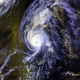 Satellite image of Iniki near peak intensity | |
| Formed | September 5, 1992 |
|---|---|
| Dissipated | September 13, 1992 |
| Highest winds |
1-minute sustained: 145 mph (230 km/h) |
| Lowest pressure | 938 mbar (hPa); 27.7 inHg |
| Fatalities | 6 direct |
| Damage |
$1.8 billion (1992 USD) (Costliest hurricane in Central Pacific history) |
| Areas affected | Hawaiʻi (particularly Kauaʻi) |
| Part of the 1992 Pacific hurricane season | |
Hurricane Iniki (/iːˈniːkiː/ ee-NEE-kee; Hawaiian: ʻiniki meaning "strong and piercing wind") was the most powerful hurricane to strike the U.S. state of Hawaii in recorded history.[1] Forming on September 5, 1992, during the strong 1990–95 El Niño, Iniki was one of eleven Central Pacific tropical cyclones during that season. It attained tropical storm status on September 8 and further intensified into a hurricane the next day. After turning north, Iniki struck the island of Kauaʻi on September 11 at peak intensity; it had winds of 145 miles per hour (233 km/h) and reached Category 4 on the Saffir–Simpson hurricane scale. It was the first hurricane to hit the state since Hurricane Iwa in the 1982 season, and the first major hurricane since Hurricane Dot in 1959. Iniki dissipated on September 13 about halfway between Hawaii and Alaska.
Iniki caused around $1.8 billion (1992 USD) of damage and six deaths. At the time, Iniki was among the costliest United States hurricanes, and it remains one of the costliest hurricanes on record in the eastern Pacific. The storm struck just weeks after Hurricane Andrew, the costliest tropical cyclone ever at the time, struck Florida.
The Central Pacific Hurricane Center (CPHC) failed to issue tropical cyclone warnings and watches 24 hours in advance. Despite the lack of early warning, only six deaths ensued. Damage was greatest on Kauaʻi, where the hurricane destroyed more than 1,400 houses and severely damaged more than 5,000. Though not directly in the path of the eye, Oʻahu experienced moderate damage from wind and storm surge.
Meteorological history

The origin of Iniki is unclear, but it possibly began as a tropical wave that exited the African coast on August 18. It moved westward across the unfavorable Atlantic Ocean and crossed Central America into the Pacific on the August 28. The wave continued rapidly westward and remained disorganized. Conditions slowly became more favorable, and, as the convection concentrated around a center, the wave was classified Tropical Depression Eighteen-E on September 5. At this time, the wave was located 1700 miles (2700 km) southwest of Cabo San Lucas or 1550 miles (2500 km) east-southeast of Hilo.[1] Initially, the thunderstorm activity was not concentrated towards the center and thus the depression was not expected to intensify beyond minimal tropical storm strength.[2] The depression continued quickly westward and remained weak until the September 8, when it slowed enough to strengthen to a tropical storm.[1]

Located at the southern periphery of a subtropical ridge, Iniki continued westward and strengthened over the unusually favorable central Pacific; it reached hurricane status on September 9 while 470 miles (760 km) south-southeast of Hilo. The subtropical ridge, which typically keeps hurricanes well away from the Hawaiian Islands, weakened due to an approaching upper level-trough and allowed Iniki to turn to the northwest. With very favorable upper-level outflow and warm water temperatures, Iniki steadily intensified, and attained major hurricane status on September 10 while south-southwest of the island chain.[1]
As Iniki turned to the north, it continued to strengthen, reaching a peak of 145 mph (235 km/h) winds on September 11 while 170 miles (270 km) south-southwest of Poʻipū on the island of Kauaʻi. It continued rapidly to the north-northeast, and made landfall on south-central Kauai early on the 11th with sustained winds of 145 mph (235 km/h), making Iniki a Category 4 hurricane on the Saffir-Simpson Hurricane Scale. The National Weather Service reported wind gusts of up to 175 mph (280 km/h). The highest recorded wind speed from Hurricane Iniki was a 227 mph (365 km/h) reading from the Navy's Makaha Ridge radar station. According to the Honolulu Advertiser, that remarkable figure was recorded at a digital weather station whose wind gauging equipment blew off after taking the measurement during the storm. After crossing the island, Iniki rapidly accelerated north-northeastward, weakened rapidly, and was absorbed by a cold front as it lost tropical characteristics and became extratropical on September 13 about halfway between Alaska and Hawaiʻi.[1]
Preparations
The Central Pacific Hurricane Center (CPHC) failed to issue tropical cyclone warnings and watches for the hurricane well in advance. For several days prior to the disaster, the CPHC and the news media forecast Iniki to remain well south of the island chain, with the only effect being some high surf conditions. Some of the standard international computer models were indicating a northward turn towards the populated Hawaiian Islands, but these were rejected by the CPHC forecasters. As late as early September 11, the CPHC suggested that Iniki would remain well to the south of the island group. It was not until a special bulletin was issued by the CPHC less than 24 hours before landfall—that any warning was given to the public.[3]
A hurricane watch was issued for Kauaʻi early on September 11 and was upgraded to a hurricane warning later that day.[1] Prior to Iniki's arrival in Kauaʻi, 8,000 people were housed in shelters, many of whom remembered Hurricane Iwa 10 years prior.[4] Because schools were canceled, traffic was light during the evacuation, and streets were clear by mid-morning. Rather than sending tourists to public shelters, two major hotels kept their occupants in the buildings during the storm's passage.[4]
The CPHC issued a tropical storm warning for Oʻahu on September 11 which was upgraded to a hurricane warning later that day.[1] Though not hit by the hurricane, Iniki's large wind field caused nearly 30,000 people to evacuate to 110 public shelters in Oʻahu. Public school buildings acted as shelters, and were for refuge only, meaning they did not provide food, cots, blankets, medications or other comfort items. Roughly one-third of Oʻahu's population participated in the evacuation, though many others went to the house of a family member or friend for shelter. The execution of the evacuations went well, beginning with the vulnerable coastal area. For those in need, vans and buses gave emergency transportation, while police manned certain overused intersections. The two main problems that occurred during the evacuation were lack of parking at shelters and exit routes for the coastlines.[4]
Impact
| Storm | Season | Cost, equivalent to US$ in 2015 |
|---|---|---|
| Manuel | 2013 | $4.27 billion |
| Paul | 1982 | $3.83 billion |
| Iniki | 1992 | $3.04 billion |
| Beatriz | 1993 | $2.79 billion |
| "Mexico" | 1959 | $2.28 billion |
| Odile | 2014 | $1.22 billion |
| Octave | 1983 | $1.22 billion |
| Agatha | 2010 | $1.2 billion |
| Aletta | 1982 | $1.12 billion |
| Norman | 1978 | $1.09 billion |
Hurricane Iniki was the costliest hurricane to strike the state of Hawaiʻi, causing $1.8 billion in damage.[5] Most damage was on the island of Kauaʻi, where the storm destroyed thousands of homes and left a large amount of the island without power, although Oʻahu also suffered significant damage. Iniki also was responsible for six deaths.[1]
The hurricane nearly struck the Central Pacific Hurricane Center in Honolulu. Had it hit there, Iniki, along with Hurricane Andrew and Typhoon Omar, would have struck each of the three National Weather Service offices responsible for tropical cyclone warnings within a two-month period.[3]
Kauaʻi
Hurricane Iniki made landfall on the south-central portion of Kauaʻi island, bringing its dangerous inner core to the entire island.[1] Upon making landfall the hurricane produced storm tides of 4.5–6 feet (1.4–1.8 m), with some portions of the coastlines having high-water marks of up to 18 feet (5.5 m). In addition, strong waves of up to 35 feet (10.5 m) in height crashed along the southern coastline for several hours, causing a debris line of more than 800 feet (250 m) inland. Because it moved quickly through the island, there were no reports of significant rainfall.[4]

Hurricane Iniki's making landfall during daylight hours, combined with the popularity of camcorders, led many Kauaʻi residents to record much of the damage as it was occurring. The footage was later used to create an hour-long video documentary.[6] Airline service was down.[7]

Hurricane Iniki's high winds caused extensive damage in Kauaʻi. 1,421 houses were destroyed, and 63 were lost from the storm surge and wave action. A total of 5,152 homes were severely damaged, while 7,178 received minor damage.[1] On the south coast, hotels and condominiums received severe damage as well. A few were restored quickly, though some took several years to be rebuilt. One hotel—the Coco Palms Resort famous for Elvis Presley's Blue Hawaii—never reopened after the hurricane.[8] Destroyed housing across the island left more than 7,000 people homeless after the storm's passage.[9]
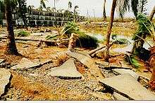
Iniki's high winds also downed 26.5% of the island's transmission poles, 37% of its distribution poles, and 35% of its 800 mile (1300 km) distribution wire system. The entire island lacked electricity and television service for an extended period of time.[9] Electric companies restored only 20% of the island's power service within four weeks of Iniki, while other areas were without power for up to three months. Also affected by the storm was the agricultural sector.[1] Though much of the sugar cane was already harvested,[9] what was left was severely damaged. The winds destroyed tender tropical plants like bananas and papayas and uprooted or damaged fruit and nut trees.[1]
Most of Iniki's damage occurred in Kauaʻi. On the island, one person died when struck by debris, while another lost her life when a portion of her house fell on her. Offshore, two Japanese nationals died when their boat capsized. The reduced death toll was likely due to well-executed warnings and preparation. More than 100 injuries can be attributed to Iniki, though most occurred in the aftermath of the hurricane.[1]
Among those on Kauaʻi was filmmaker Steven Spielberg, who was preparing for the final day of on-location shooting of the film Jurassic Park. He and the 130 of his cast and crew remained safely in a hotel during Iniki's passage.[10][11] According to Spielberg, "every single structure was in shambles; roofs and walls were torn away; telephone poles and trees were down as far as the eye could see." Members of the film's crew helped to clear some of the debris off of nearby roads.[10]
Oʻahu
Upon passing by Oʻahu, Iniki produced tides of 1.7–3 feet (0.5–0.9 m) above normal.[4] Prolonged periods of high waves severely eroded and damaged the southwestern coast of Oʻahu, with the areas most affected being Barbers Point through Kaʻena.[1] The Waiʻanae coastline experienced the most damage, with waves and storm surge flooding the second floor of beachside apartments.[12] In all, Hurricane Iniki caused several million dollars in property damage,[4] and two deaths on Oʻahu.[1]
Big Island
Damage on the big island was minor. Seas of 10 ft (3.0 m) were reported, along with 40 mph (65 km/h) winds.[13] In Kona Harbor, three or four sailboats were tossed onto the rocks and one trimaran at another harbor was sunk. The Napoʻopoʻo Beach, in the Kealakekua Bay lost some sand and to this day has never been the same.[14]
Aftermath
| Hurricane | Season | Landfall winds | Ref. |
|---|---|---|---|
| Patricia | 2015 | 150 mph (240 km/h) | [15] |
| Madeline | 1976 | 145 mph (230 km/h) | [16] |
| Iniki | 1992 | 145 mph (230 km/h) | [1] |
| Unnamed | 1957 | 140 mph (220 km/h) | [17] |
| “Mexico” | 1959 | 140 mph (220 km/h) | [17] |
| Kenna | 2002 | 140 mph (220 km/h) | [18] |
| Olivia | 1967 | 125 mph (205 km/h) | [17] |
| Tico | 1983 | 125 mph (205 km/h) | [19] |
| Lane | 2006 | 125 mph (205 km/h) | [20] |
| Odile | 2014 | 125 mph (205 km/h) | [21] |
| Kiko | 1989 | 120 mph (195 km/h) | [22] |
| Olivia | 1975 | 115 mph (185 km/h) | [23] |
| Liza | 1976 | 115 mph (185 km/h) | [16] |

Immediately after the storm, many were relieved to have survived the worst of the Category 4 hurricane; their complacency turned to apprehensiveness due to lack of information, as every radio station was out and there was no news available for several days. Because Iniki knocked out electrical power for most of the island, communities held parties to necessarily consume perishable food from unpowered refrigerators and freezers. Though food markets allowed those affected to take what they needed, many Kauaʻi citizens insisted on paying. In addition, entertainers from all of Hawaiʻi, including Graham Nash (who owns a home on the north shore of Kauaʻi) and the Honolulu Symphony, provided free concerts to the victims.[8]
Looting occurred in the aftermath of Iniki, though it was very minor. A group of Army Corps of Engineers, who experienced the looting of Hurricane Andrew just weeks before, were surprised at the overall calmness and lack of violence on the island. Although electrical power was restored to most of the island approximately six weeks following the hurricane, students returned to Kauaʻi public schools two weeks after the disaster. Kauaʻi citizens remained hopeful for monetary aid from the government or insurance companies, though after six months they felt annoyed with the lack of help.[8] The military effectively provided aid for their immediate needs, though, and help arrived before local officials requested aid.[24]
Amateur radio proved to be extremely helpful during the three weeks after the storm, with volunteers coming from the neighboring islands as well as from around the Pacific to assist in the recovery. There was support of local government communications in Lihue in the first week of recovery [12] as well as a hastily organized effort by local operators to assist with the American Red Cross and their efforts to provide shelters and disaster relief centers across Kauaʻi.[25]
In the months after the storm, many insurance companies left Hawaiʻi. To combat this, State Governor John D. Waihee III enacted the Hurricane Relief Fund in 1993 to help unprotected Hawaiʻi residents. The fund was never needed for another Hawaiʻi hurricane, and it was stopped in 2000 when insurance companies returned to the island.[26]
It is thought that Hurricane Iniki blew apart many chicken coops, some possibly used to house fighting chickens; this caused a dramatic increase in the numbers of wild chickens roaming Kauaʻi.[27]
The name Iniki was retired due to this storm, and was replaced with Iolana within the Central North Pacific tropical storm list.[28] Less than three days after Iniki struck, Hurricane Orlene struck the Big Island as a depression.
See also
- List of Pacific hurricanes
- List of retired Pacific hurricane names
- List of Category 4 Pacific hurricanes
References
- 1 2 3 4 5 6 7 8 9 10 11 12 13 14 15 16 Central Pacific Hurricane Center. The 1992 Central Pacific Tropical Cyclone Season (Report). United States National Oceanic and Atmospheric Administration's National Weather Service. Retrieved November 28, 2007.
- ↑ Tropical Depression Eighteen-E Discussion 2 (Report).
- 1 2 Ronald H. Brown (1993). "Natural Disaster Survey Report: Hurricane Iniki" (PDF). Retrieved 2006-03-13.
- 1 2 3 4 5 6 US Army Corps of Engineers (1993). "Hurricane Iniki Assessment" (PDF). US Military. Retrieved 2006-03-13.
- ↑ National Hurricane Center (2004). "Costliest U.S. Hurricanes 1900–2004 (unadjusted)". Retrieved 2006-03-18.
- ↑ "Hurricane Iniki: Through The Eyes of Kauai's People" (DL&R Productions)
- ↑ "Big Waves at Waikiki but Oahu Is Mostly Spared". The New York Times. September 13, 1992.
- 1 2 3 Anthony Sommer (2002). "The people of Kauai lived through a nightmare when the powerful storm struck". Honolulu Star-Bulletin. Retrieved 2006-03-13.
- 1 2 3 Unknown (1992). "Broadcast Journalism: Write to the Bite". Unknown. Retrieved 2006-03-13.
- 1 2 Shay, Don; Duncan, Jody (June 1993). The Making of Jurassic Park. Ballantine Books. pp. 85–87. ISBN 0-345-38122-X.
- ↑ Al Kamen (September 13, 1992). "Hawaii Hurricane Devastates Kauai". Washington Post. Retrieved 2006-03-13.
- 1 2 Ron Hashiro (1993). "Hurricane Iniki Rallies Amateurs". American Amateur Radio Relay League, Inc. Retrieved 2006-03-13.
- ↑ Al Kamen (1992-09-13). "Hawaii Hurricane Devastates Kauai: Iniki Blamed For 3 Deaths, Scores of Injuries". The Washington Post. Retrieved September 8, 2012.
- ↑ "Big Island Hawaii Beaches". big-island-bigisland.com. Retrieved September 8, 2012.
- ↑ Todd B. Kimberlain; Eric S. Blake; John P. Cangialosi (February 1, 2016). Hurricane Patricia (PDF) (Report). Tropical Cyclone Report. Miami, Florida: National Hurricane Center. Retrieved February 4, 2016.
- 1 2 Gunther, Emil B. (April 1, 1977). "Eastern Pacific Tropical Cyclones of 1976". Monthly Weather Review. 105 (4): 508–522. Bibcode:1977MWRv..105..508G. doi:10.1175/1520-0493(1977)105<0508:EPTCO>2.0.CO;2. Retrieved April 25, 2010.
- 1 2 3 Blake, Eric S; Gibney, Ethan J; Brown, Daniel P; Mainelli, Michelle; Franklin, James L; Kimberlain, Todd B; Hammer, Gregory R (2009). Tropical Cyclones of the Eastern North Pacific Basin, 1949-2006 (PDF). Archived from the original on July 28, 2013. Retrieved June 14, 2013.
- ↑ Franklin, James L (December 26, 2002). Hurricane Kenna 2002 (Tropical Cyclone Report). United States National Oceanic and Atmospheric Administration's National Weather Service. Retrieved May 26, 2012.
- ↑ Gunther, Emil B; Cross, R.L. (1984). "Eastern North Pacific Tropical Cyclones of 1983". Monthly Weather Review. 112 (7): 1419–1440. Bibcode:1984MWRv..112.1419G. doi:10.1175/1520-0493(1984)112<1419:ENPTCO>2.0.CO;2.
- ↑ Knabb, Richard D (November 3, 2006). Hurricane Lane 2006 (PDF) (Tropical Cyclone Report). United States National Oceanic and Atmospheric Administration's National Weather Service. Retrieved May 26, 2012.
- ↑ Daniel P. Brown and Christopher W. Landsea (September 15, 2014). Hurricane Odile Tropical Cyclone Update: Odile Makes Landfall Near Cabo San Lucas. National Hurricane Center (Report). Miami, Florida: National Oceanic and Atmospheric Administration. Retrieved September 15, 2014.
- ↑ Mayfield, Britt Max (November 18, 1989). Hurricane Kiko 1989 (Report). United States National Oceanic and Atmospheric Administration's National Weather Service. p. 1. Retrieved May 26, 2012.
- ↑ Baum, Robert A (1976). "Eastern North Pacific Tropical Cyclones of 1975" (PDF). Monthly Weather Review. 104: 487. Bibcode:1976MWRv..104..475B. doi:10.1175/1520-0493(1976)104<0475:ENPTCO>2.0.CO;2.
- ↑ J. Dexter Peach (1993). "What Hurricane Andrew Tells Us About How To Fix FEMA". United States General Accounting Office. Archived from the original on 2006-07-08. Retrieved 2006-03-18.
- ↑ Greg Pool (1993). "Iniki and the American Red Cross". Worldradio. 22 (12): 1, 18–20. Retrieved 2007-12-17.
- ↑ "State should keep hurricane fund intact for next disaster". Honolulu Star-Bulletin. 2001. Retrieved 2006-03-18.
- ↑ "Something's killing off Kauai chickens". Honolulu Advertiser. 2007. Retrieved 2007-10-02.
- ↑ "Answers archive: Hurricane history and climatology". USA Today. USAToday.com. 2011. Retrieved 2013-11-08.
External links
- Central Pacific Hurricane Center: Hurricane Iniki
- NWS Service Assessment
- NHC 18-E archive
- Hurricane Iniki Videos
| Eastern | |
|---|---|
| Central | |
| |
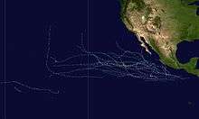
Tropical cyclones of the 1992 Pacific hurricane season | ||
|---|---|---|
 | ||
| ||