Plantation Island, Florida
| Plantation Island, Florida | |
|---|---|
| Census-designated place | |
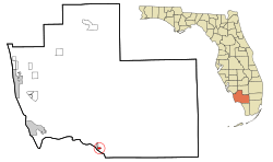 Location in Collier County and the state of Florida | |
| Coordinates: 25°50′47″N 81°22′6″W / 25.84639°N 81.36833°WCoordinates: 25°50′47″N 81°22′6″W / 25.84639°N 81.36833°W | |
| Country |
|
| State |
|
| County |
|
| Area | |
| • Total | 0.58 sq mi (1.51 km2) |
| • Land | 0.57 sq mi (1.48 km2) |
| • Water | 0.01 sq mi (0.03 km2) |
| Elevation | 4 ft (1 m) |
| Population (2010) | |
| • Total | 163 |
| • Density | 285/sq mi (110.0/km2) |
| Time zone | Eastern (EST) (UTC-5) |
| • Summer (DST) | EDT (UTC-4) |
| FIPS code | 12-57492[1] |
| GNIS feature ID | 0289027[2] |
Plantation Island is a census-designated place (CDP) in Collier County, Florida, United States. The population was 163 at the 2010 census.[3] It is part of the Naples–Marco Island Metropolitan Statistical Area.
Geography
Plantation Island is located in southern Collier County at 25°50′47″N 81°22′6″W / 25.84639°N 81.36833°W (25.846346, -81.368274),[4] on the shore of Chokoloskee Bay near the northwest end of Everglades National Park. It is bordered to the west by Everglades City.
According to the United States Census Bureau, the CDP has a total area of 0.58 square miles (1.5 km2), of which 0.012 square miles (0.03 km2), or 1.90%, is water.[3]
Demographics
As of the census[1] of 2000, there were 202 people, 92 households, and 57 families residing in the CDP. The population density was 344.1 people per square mile (132.2/km²). There were 158 housing units at an average density of 269.2/sq mi (103.4/km²). The racial makeup of the CDP was 96.53% White. Hispanic or Latino of any race were 3.47% of the population.
There were 92 households out of which 18.5% had children under the age of 18 living with them, 54.3% were married couples living together, 3.3% had a female householder with no husband present, and 38.0% were non-families. 28.3% of all households were made up of individuals and 9.8% had someone living alone who was 65 years of age or older. The average household size was 2.20 and the average family size was 2.65.
In the CDP the population was spread out with 14.4% under the age of 18, 9.4% from 18 to 24, 21.3% from 25 to 44, 32.7% from 45 to 64, and 22.3% who were 65 years of age or older. The median age was 48 years. For every 100 females there were 104.0 males. For every 100 females age 18 and over, there were 119.0 males.
The median income for a household in the CDP was $38,750, and the median income for a family was $45,208. Males had a median income of $31,667 versus $30,833 for females. The per capita income for the CDP was $21,581. About 13.8% of families and 14.6% of the population were below the poverty line, including none of those under the age of eighteen and 11.4% of those sixty five or over.
References
- 1 2 "American FactFinder". United States Census Bureau. Retrieved 2008-01-31.
- ↑ "US Board on Geographic Names". United States Geological Survey. 2007-10-25. Retrieved 2008-01-31.
- 1 2 "Geographic Identifiers: 2010 Demographic Profile Data (G001): Plantation Island CDP, Florida". U.S. Census Bureau, American Factfinder. Retrieved July 16, 2014.
- ↑ "US Gazetteer files: 2010, 2000, and 1990". United States Census Bureau. 2011-02-12. Retrieved 2011-04-23.
Municipalities and communities of Collier County, Florida, United States | ||
|---|---|---|
| Cities | 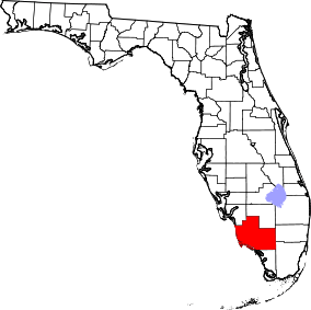 | |
| CDPs | ||
| Unincorporated communities | ||