Catahoula Parish, Louisiana
| Catahoula Parish, Louisiana | |
|---|---|
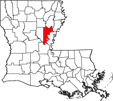 Location in the U.S. state of Louisiana | |
 Louisiana's location in the U.S. | |
| Founded | March 23, 1808 |
| Named for | Tensas word for big, clear lake |
| Seat | Harrisonburg |
| Largest town | Jonesville |
| Area | |
| • Total | 739 sq mi (1,914 km2) |
| • Land | 708 sq mi (1,834 km2) |
| • Water | 31 sq mi (80 km2), 4.2% |
| Population | |
| • (2010) | 10,407 |
| • Density | 15/sq mi (6/km²) |
| Congressional district | 5th |
| Time zone | Central: UTC-6/-5 |
| Website |
louisiana |
Catahoula Parish (French: Paroisse de Catahoula) is a parish in the U.S. state of Louisiana. As of the 2010 census, the population was 10,407.[1] Its seat is Harrisonburg,[2] on the Ouachita River. The parish was formed in 1808, shortly after the United States acquired this territory in the Louisiana Purchase of 1803.[3]
History
Prehistory
Catahoula Parish was the home to many succeeding Native American groups in the thousands of years before European settlements began. Peoples of the Marksville culture, Troyville culture, Coles Creek culture and Plaquemine culture built villages and mound sites throughout the area. Notable examples include Peck Mounds, and the Troyville Earthworks. The Troyville Earthworks have components dating from 100 BCE to 700 CE during the Baytown to the Troyville-Coles Creek periods.[4]
It once had the tallest mound in Louisiana at 82 feet (25 m) in height; it was the second-tallest mound in North America (after Monk's Mound at Cahokia Mounds). This mound was destroyed to make way for the Jonesville bridge over the Black River.[4]
Historic era
This area was settled primarily by migrants from the southern United States after the Louisiana Purchase, when the US acquired the vast, former French-claimed territory west of the Mississippi River. White migrants to north and central Louisiana were from the South, and were mainly of British descent and Protestant religions. They brought a new influence into Louisiana. Some also brought or purchased African-American slaves to work on larger plantations. Many of these were from the Upper South, which sold slaves through the domestic market. They brought their own cultural influences as well.
The parish was founded in 1808 and originally incorporated a very large area. As population increased in the region, new parishes were organized from the territory first included in Catahoula Parish. The parish was divided by the state in 1910, after La Salle Parish was formed from its old western section. As one of the new parishes organized during early United States settlement of this part of the state, it has had the third most boundary changes since that time. Only Natchitoches and Ouachita parishes have had more revisions of boundaries.
At the start of the American Civil War, James G. Taliaferro, a delegate to the Louisiana state secessionist convention from Catahoula Parish, argued strongly against leaving the American Union. Taliaferro "denied the constitutional right [of a state] to leave the Union and painted a gloomy picture of economic chaos, blighted prosperity, staggering taxation and 'fatal prostration of Louisiana's interests under a southern Confederation,' and he could see no way ahead to prevent final anarchy and war. So 'radical' were the ideas of Taliaferro that the convention refused to print his protest in the pages of [its journal]."[5]
S. McCain]] of Arizona.[6] The 2008 totals mirrored those of 2004, when Catahoula Parish cast 3,219 (65.0 percent) for President George W. Bush and 1,673 ballots (34.8 percent) for his Democratic rival, Senator John F. Kerry of Massachusetts.[7] Local officials are almost entirely Democratic in affiliation. Republicans rarely contest such elections.
Catahoula Hog Dog
Catahoula Parish lays claim to its namesake Catahoula Leopard dog breed. The Catahoula breed was owned by Colonel James "Jim" Bowie of the Alamo and his brother Rezin Bowie, both of Louisiana.[8] During the early 1900s, Theodore Roosevelt used the Catahoula when hunting.[9] Louisiana Governor Earl Kemp Long also collected these dogs.[8]
Geography
According to the U.S. Census Bureau, the parish has a total area of 739 square miles (1,910 km2), of which 708 square miles (1,830 km2) is land and 31 square miles (80 km2) (4.2%) is water.[10] It is home to Sandy Lake.
Major highways
Adjacent parishes
- Franklin Parish (north)
- Tensas Parish (northeast)
- Concordia Parish (east)
- Avoyelles Parish (south)
- La Salle Parish (west)
- Caldwell Parish (northwest)
National protected area
Demographics
| Historical population | |||
|---|---|---|---|
| Census | Pop. | %± | |
| 1820 | 2,287 | — | |
| 1830 | 2,581 | 12.9% | |
| 1840 | 4,955 | 92.0% | |
| 1850 | 7,132 | 43.9% | |
| 1860 | 11,651 | 63.4% | |
| 1870 | 8,475 | −27.3% | |
| 1880 | 10,277 | 21.3% | |
| 1890 | 12,002 | 16.8% | |
| 1900 | 16,351 | 36.2% | |
| 1910 | 10,415 | −36.3% | |
| 1920 | 11,074 | 6.3% | |
| 1930 | 12,451 | 12.4% | |
| 1940 | 14,618 | 17.4% | |
| 1950 | 11,834 | −19.0% | |
| 1960 | 11,421 | −3.5% | |
| 1970 | 11,769 | 3.0% | |
| 1980 | 12,287 | 4.4% | |
| 1990 | 11,065 | −9.9% | |
| 2000 | 10,920 | −1.3% | |
| 2010 | 10,407 | −4.7% | |
| Est. 2015 | 10,147 | [11] | −2.5% |
| U.S. Decennial Census[12] 1790-1960[13] 1900-1990[14] 1990-2000[15] 2010-2013[1] | |||
As of the census[16] of 2000, there were 10,920 people, 4,082 households, and 2,992 families residing in the parish. The population density was 16 people per square mile (6/km²). There were 5,351 housing units at an average density of 8 per square mile (3/km²). The racial makeup of the parish was 71.78% White, 27.12% Black or African American, 0.19% Native American, 0.13% Asian, 0.19% from other races, and 0.59% from two or more races. 0.92% of the population were Hispanic or Latino of any race.
There were 4,082 households out of which 32.70% had children under the age of 18 living with them, 54.70% were married couples living together, 14.50% had a female householder with no husband present, and 26.70% were non-families. 24.30% of all households were made up of individuals and 11.30% had someone living alone who was 65 years of age or older. The average household size was 2.55 and the average family size was 3.02.
In the parish the population was spread out with 25.80% under the age of 18, 10.00% from 18 to 24, 26.80% from 25 to 44, 23.00% from 45 to 64, and 14.40% who were 65 years of age or older. The median age was 37 years. For every 100 females there were 100.60 males. For every 100 females age 18 and over, there were 98.00 males.
The median income for a household in the parish was $22,528, and the median income for a family was $27,206. Males had a median income of $26,181 versus $18,427 for females. The per capita income for the parish was $12,608. About 22.60% of families and 28.10% of the population were below the poverty line, including 41.80% of those under age 18 and 20.10% of those age 65 or over.
Education
Catahoula Parish School Board operates local public schools.
National Guard
The 1087TH Transportation Company of the 165TH CSS (combat service support) Battalion of the 139TH RSG (regional support group) resides in Jonesville, Louisiana.
Communities
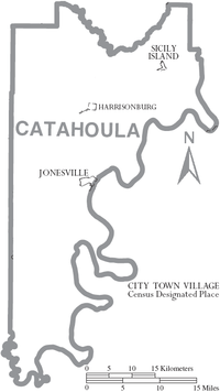
Town
Villages
Census-designated place
Unincorporated communities
- Aimwell
- Enterprise
- Foules
- Larto
- Leland
- Manifest
- Sandy Lake
Notable residents
- William B. Atkins, former member of both houses of the state legislature; resident of Jonesville
- Leo Boothe, longest serving District Judge of Catahoula Parish and Concordia Parish. (1991-2015)
- J. C. "Sonny" Gilbert, late state senator and state representative
- Ralph E. King, Winnsboro physician who represented Catahoula Parish in the Louisiana State Senate from 1944 to 1952 and again from 1956 to 1960
- St. John Richardson Liddell, Confederate general in the American Civil War, owned large plantation in Catahoula Parish
- Charles A. Marvin, late judge based in Webster Parish
- David I. Patten, late state representative
- Joe Raymond Peace, football coach
- William S. Peck, Jr., politician
- William S. Peck, Sr., politician
- Dan Richey, former member of both houses of the state legislature
- Chris Shivers, two-time (2000, 2003) PBR World Champion bull rider
See also
References
- 1 2 "State & County QuickFacts". United States Census Bureau. Retrieved August 20, 2013.
- ↑ "Find a County". National Association of Counties. Archived from the original on 2011-05-31. Retrieved 2011-06-07.
- ↑ "Catahoula Parish". Center for Cultural and Eco-Tourism. Retrieved September 6, 2014.
- 1 2 "Indian Mounds of Northeast Louisiana : Troyville Earthworks". Retrieved 2011-10-22.
- ↑ John D. Winters, The Civil War in Louisiana, Baton Rouge: Louisiana State University Press, 1963, ISBN 0-8071-0834-0, p. 13
- ↑ "Louisiana general election returns, November 4, 2008". sos.louisiana.gov. Retrieved June 15, 2010.
- ↑ "Louisiana general election returns, November 2, 2004". sos.louisiana.gov. Retrieved June 15, 2010.
- 1 2 Cracker Catahoulas
- ↑ Molosser World: Catahoula Bulldog
- ↑ "2010 Census Gazetteer Files". United States Census Bureau. August 22, 2012. Retrieved August 27, 2014.
- ↑ "County Totals Dataset: Population, Population Change and Estimated Components of Population Change: April 1, 2010 to July 1, 2015". Retrieved July 2, 2016.
- ↑ "U.S. Decennial Census". United States Census Bureau. Archived from the original on May 11, 2015. Retrieved August 27, 2014.
- ↑ "Historical Census Browser". University of Virginia Library. Retrieved August 27, 2014.
- ↑ "Population of Counties by Decennial Census: 1900 to 1990". United States Census Bureau. Retrieved August 27, 2014.
- ↑ "Census 2000 PHC-T-4. Ranking Tables for Counties: 1990 and 2000" (PDF). United States Census Bureau. Retrieved August 27, 2014.
- ↑ "American FactFinder". United States Census Bureau. Archived from the original on 2013-09-11. Retrieved 2008-01-31.
External links
| Wikimedia Commons has media related to Catahoula Parish, Louisiana. |
- Heinrich, P. V., 2008, Woodville 30 x 60 minute geologic quadrangle. Louisiana Geological Survey, Baton Rouge, Louisiana.
 |
Caldwell Parish | Franklin Parish | Tensas Parish | |
| La Salle Parish | |
Concordia Parish | ||
| ||||
| | ||||
| Avoyelles Parish |
Municipalities and communities of Catahoula Parish, Louisiana, United States | ||
|---|---|---|
| Town | | |
| Villages | ||
| CDP | ||
| Other unincorporated communities | ||
| Footnotes | ‡This populated place also has portions in an adjacent parish or parishes | |
Coordinates: 31°40′N 91°51′W / 31.67°N 91.85°W