Vernon Parish, Louisiana
| Vernon Parish, Louisiana | |
|---|---|
 Vernon Parish Courthouse | |
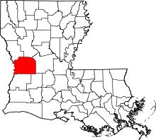 Location in the U.S. state of Louisiana | |
 Louisiana's location in the U.S. | |
| Founded | March 30, 1871 |
| Named for | Mount Vernon |
| Seat | Leesville |
| Largest city | Leesville |
| Area | |
| • Total | 1,341 sq mi (3,473 km2) |
| • Land | 1,328 sq mi (3,440 km2) |
| • Water | 14 sq mi (36 km2), 1.0% |
| Population | |
| • (2010) | 52,334 |
| • Density | 39/sq mi (15/km²) |
| Congressional district | 4th |
| Time zone | Central: UTC-6/-5 |
| Website |
www |
Vernon Parish (French: Paroisse de Vernon) is a parish located in the U.S. state of Louisiana. As of the 2010 census, the population was 52,334.[1] The parish seat is Leesville.[2] The parish was founded in 1871.[3]
Vernon Parish is part of the Fort Polk South, LA Micropolitan Statistical Area, which is also included in the DeRidder-Fort Polk South, LA Combined Statistical Area.
History
On March 30, 1871, the Louisiana General Assembly passed an act designating the creation of Vernon Parish, by taking territory from the parishes of Natchitoches, Rapides, and Sabine. While there seem to be four stories surrounding the naming of the Parish, only one is affirmed officially by the State[4] which is that it was named in honor of Mt. Vernon, the home of George Washington. Other stories, though folklore, are: 1) that it was named after a race horse owned by Joe Moore, one of the members of the committee chosen to name the parish, who claimed that by naming the parish after his fast horse the committee would insure the growth of the parish to be as fast as his horse: 2) that it was named after a popular teacher who had been an officer in the Royal Navy, only mentioned as "Mr. Vernon". This was not to honor him, but to avoid disputes among the parish founders whom each wanted to name the parish after themselves. The final story is similar to the first and claims that the committee had been arguing over the name while drinking in a store, and in an attempt to preserve his precious whiskey and profits, the host suggested the committee stop a local man with a mule pulling a cart and that they should name the parish whatever the man said. The man answered them "I calls him Vernon, 'cause he's the fastes' mule in de country."[5] Originally the area comprising Vernon was a part of a tract of land that was in dispute between the United States and Spain, this land was called the "Neutral Strip". As a result of this dispute the area became a haven for outlaws. Prior to the Louisiana Purchase in 1803, the only persons who came to the area were a few French and Spanish settlers. It was also during this period that Dr. Burr established the community of Burr Ferry. This community was known as the "Gateway to Louisiana". Also located near this community, there still stands an artillery site (now called the "Confederate Breast Works"), which was manned by the Confederacy to guard against Union movements along the Nolan Trace[6] during the Civil War.[7]


Leesville has been the parish seat of Vernon since the parish was created, though it was not incorporated until February 15, 1900. The city, although founded by Dr. Edmund E. Smart, was named by Senator R. Smart, his father, in honor of General Robert E. Lee. At the time of Leesville's founding, the site was the home of a plantation owned by Dr. Smart. The house from that plantation is still found today at the corner of Lula and First street.[7]

In the late 1890s the timber industry, which was the dominant industry in the parish from its creation, began to boom with the arrival of the Kansas City Southern Railway in 1897, which is still in operation today.[7]
In the period after World War I, Vernon became the site of two socialist based communities; the Llano del Rio Cooperative Colony[9] (which became New Llano) established in 1917 and the Christian Commonwealth Colony. These colonies attempted to attract economists and sociologists for the purpose of conducting an experiment in communal membership and the sharing of labor duties. Of the two colonies the Llano del Rio was the largest with over 10,000 people and was also the longest surviving community. Both colonies failed in the 1930s when the depression hit.[7]
In 1941, the United States Army opened Camp Polk, shortly after the 1939-40 maneuvers. Camp Polk quickly surpassed the timber industry as the dominant force in the parish's economy, which became evident in the parish seat of Leesville when its population jumped from 3,500 to 18,000 after the camp opened. The Camp receives its name from Leonidas Polk, the first Episcopal Bishop in Louisiana, known as the "Fighting Bishop of the Confederacy" and served as one of the major training camps during World War II. Today, now called Fort Polk is the 5th largest military installation in the nation, containing approximately 200,000 acres (800 km²). With the constant movement of soldiers and their dependents in and out of the parish, Vernon experiences a unique blend of culture from numerous states and countries creating a true "melting pot."[7]
Geography
According to the U.S. Census Bureau, the parish has a total area of 1,341 square miles (3,470 km2), of which 1,328 square miles (3,440 km2) is land and 14 square miles (36 km2) (1.0%) is water.[10] It is the largest parish in Louisiana by land area.
Major highways
Adjacent parishes and counties
- Sabine Parish (northwest)
- Natchitoches Parish (north)
- Rapides Parish (east)
- Allen Parish (southeast)
- Beauregard Parish (south)
- Newton County, Texas (west)
National protected area
- Kisatchie National Forest (part)
Demographics
| Historical population | |||
|---|---|---|---|
| Census | Pop. | %± | |
| 1880 | 5,160 | — | |
| 1890 | 5,903 | 14.4% | |
| 1900 | 10,327 | 74.9% | |
| 1910 | 17,384 | 68.3% | |
| 1920 | 20,493 | 17.9% | |
| 1930 | 20,047 | −2.2% | |
| 1940 | 19,142 | −4.5% | |
| 1950 | 18,974 | −0.9% | |
| 1960 | 18,301 | −3.5% | |
| 1970 | 53,794 | 193.9% | |
| 1980 | 53,475 | −0.6% | |
| 1990 | 61,961 | 15.9% | |
| 2000 | 52,531 | −15.2% | |
| 2010 | 52,334 | −0.4% | |
| Est. 2015 | 50,803 | [11] | −2.9% |
| U.S. Decennial Census[12] 1790-1960[13] 1900-1990[14] 1990-2000[15] 2010-2013[1] | |||
As of the census[16] of 2010, there were 52,334 people residing in the parish. The population density was 39.4 people per square mile (15/km²). The racial makeup of the parish was 75.70% White, 14.2% Black or African American, 1.4% Native American, 1.8% Asian, 0.50% Pacific Islander, and 4.1% from two or more races. 7.2% of the population were Hispanic or Latino of any race.
In the parish the population was spread out with 9.2% under 5 years of age, 27.7% under the age of 18, and 9.4% who were 65 years of age or older. Vernon parish residents are 48.8% female and 51.2% male.
There were 18,590 households with an average household size was 2.644. The median income for a household in the parish was $42,322. The per capita income for the parish was $14,036. About 16.2% of the population were below the poverty line, including 18.60% of those under age 18 and 14.80% of those age 65 or over.
Education

Primary and secondary education
All public schools in Vernon Parish are operated by the Vernon Parish School Board, which operates 18 public schools and one optional school.[17] Schools providing a secondary education include:
- Evans High School (Grades PK-12)
- Hicks High School (Grades PK-12)
- Hornbeck High School (Grades PK-12)
- Pitkin High School (Grades PK-12)
- Simpson High School (Grades PK-12)
- Anacoco High School (Grades 7-12)
- Pickering High School (Grades 7-12)
- Rosepine Junior/Senior High School (Grades 7-12)
- Leesville High School (Grades 9-12)
- Vernon Parish Optional School (Grades 7-12)[18]
Colleges and universities
The Louisiana Technical College (LTC) system operates the Lamar Salter campus south of New Llano. The Central Louisiana Technical College Lamar Salter campus is one of 40 LTC campuses across the state.[19]
Northwestern State University (NSU), is a four-year public university primarily situated in Natchitoches, Louisiana and a part of the a part of the University of Louisiana System. The NSU-Leesville/Fort Polk Campus is located on Highway 467 near Fort Polk and serves the civilian communities of Vernon, Beauregard, and Sabine parishes, as well as the military community at Fort Polk. http://leesville.nsula.edu/
The Fort Polk Education Center offers self-development opportunities for Service members, military family members, Department of the Defense employees, military Retirees, Department of Defense contractors, and civilians from the local community in the classroom, distance learning, and online environments. Civilian students coming to the post for classes are required to use the main entrance located off U.S. Highway 171.[20]
Central Michigan University (CMU) operates a campus at Fort Polk.[21]
Central Texas College (CTC) is a public, open-admission community college offering associate degrees and certificate programs in academic, professional and vocational/technical fields. Due to its proximity to Fort Hood, CTC has evolved from a small junior college into a college catering to the military. CTC also help students transition from a 2-year to a 4-year degree through numerous articulation agreements with 4-year institutions nationwide.[22]
Louisiana State University offers a Master of Arts in Liberal Arts.[23]
The Upper Iowa University (UIU) at Fort Polk offers classes on post to both military personnel and civilians in the area. It was opened in 1995 and offers bachelor's degrees in nine majors. Courses can also be blended with UIU distance learning programs (online and independent study) to complete 11 other majors. Certificate programs are also available. UIU offers courses on post during five eight-week terms during the academic year. All courses are offered during the evenings and on weekends.[24]
Public libraries
The Vernon Parish Library operates public libraries. It operates the main library and the Dunbar Branch Library in Leesville and the Pitkin Branch Library in Pitkin.[25]
National Guard
The Louisiana Army National Guard maintains a maintenance facility which services its vehicles on Fort Polk. 3-156 IB part of 256th Tiger Brigade is located at fort polk.
Communities

Cities
Towns
Villages
Census-designated places
Unincorporated communities
Notable people

- Bert A. Adams, state representative from Vernon Parish from 1956 to 1968[28]
- James Armes, state representative for Beauregard and Vernon parishes since 2008; landscape contractor in Leesville[29]
- Walter O. Bigby, Louisiana state representative from Bossier Parish from 1968–1979, known as "Dean of the House".
- Allen Bradley, DeRidder lawyer and businessman who represented Vernon and Beauregard parishes in the Louisiana House of Representatives from 1984 to 1992
- Frank A. Howard, former Vernon Parish sheriff and Republican member of the Louisiana House of Representatives from Vernon, Sabine, Red River, and De Soto parishes.[30]
- Jim McCrery, Republican former U.S. Representative for Louisiana's 4th congressional district, was born in Shreveport, but reared in Leesville, where he graduated from Leesville High School in 1967.
- Bryan A. Poston, member of the Louisiana State Senate from 1964–1992, was a Hornbeck businessman.[31]
- Frank A. Howard, a Hornbeck visionary and former Vernon Parish Sheriff, has been representing the 24th district in the Louisiana House of Representatives since his election in 2007.[32]
- Charles M. Poston, Sr., of Hornbeck, was a Louisiana state senator, 1960–1964; father of Bryan A. Poston.
- Eddie Fuller - National Football League player, running back with the Buffalo Bills, also played for Louisiana State University and was part of the play which became known as the "Earthquake game".
- Demond Mallet - Professional basketball player, guard. Played in the German League and currently with Spanish Joventut Badalona.
- Claude Anthony "Buddy" Leach, Jr. - Politician, former member of the United States House of Representatives, Louisiana House of Representatives, and Louisiana Democratic state chairman; unsuccessful candidate for governor in 2003 and for the Louisiana State Senate in 2007
- Kevin Mawae - National Football League All-Pro Center for the Tennessee Titans
- Keith Munyan - Born in Leesville in 1961 but moved away as a toddler, he is a Los Angeles photographer known for his multiple celebrity clients.
- D'Anthony Smith - National Football League Born in Berlin, Germany, but spent his teen years in Leesville while family was stationed at Fort Polk. Attended Pickering High School in Leesville and played collegiate football at Louisiana Tech University. Currently plays for the Chicago Bears
See also
References
- 1 2 "State & County QuickFacts". United States Census Bureau. Retrieved August 18, 2013.
- ↑ "Find a County". National Association of Counties. Archived from the original on May 31, 2011. Retrieved 2011-06-07.
- ↑ "Vernon Parish". Center for Cultural and Eco-Tourism. Retrieved September 5, 2014.
- ↑ The State of Louisiana maintains an official website for each of the State's 64 parishes at Louisiana.gov.
- ↑ All four found in "Tall Pines II: A History of Vernon Parish, Louisiana and its People" / Wise, Erbon, Library Of Congress # 87-51644
- ↑ The Nolan Trace
- 1 2 3 4 5 Information in the History section may be found on the Greater Vernon Parish Chamber of Commerce Website.
- ↑ The map may be found at this website, and is the result of the hard work of Pam Rietsch.
- ↑ Not to be confused with the Llano del Rio established in Antelope Valley, California in 1915 and abandoned in 1917.
- ↑ "2010 Census Gazetteer Files". United States Census Bureau. August 22, 2012. Retrieved September 2, 2014.
- ↑ "County Totals Dataset: Population, Population Change and Estimated Components of Population Change: April 1, 2010 to July 1, 2015". Retrieved July 2, 2016.
- ↑ "U.S. Decennial Census". United States Census Bureau. Archived from the original on May 11, 2015. Retrieved September 2, 2014.
- ↑ "Historical Census Browser". University of Virginia Library. Retrieved September 2, 2014.
- ↑ "Population of Counties by Decennial Census: 1900 to 1990". United States Census Bureau. Retrieved September 2, 2014.
- ↑ "Census 2000 PHC-T-4. Ranking Tables for Counties: 1990 and 2000" (PDF). United States Census Bureau. Retrieved September 2, 2014.
- ↑ "American FactFinder". United States Census Bureau. Archived from the original on September 11, 2013. Retrieved 2008-01-31.
- ↑ "Vernon Parish School District - School List".
- ↑ "Vernon Parish Optional School History".
- ↑ "Central Louisiana Technical College-Lamar Salter-Campus".
- ↑ "Fort Polk Education Center".
- ↑ "Central Michigan University at Fort Polk, Louisiana".
- ↑ "Central Texas College - Fort Polk Site".
- ↑ "Louisiana State University - Special Programs".
- ↑ "The Upper Iowa Center at Fort Polk, LA".
- ↑ "Sexual Predator Policy." (Archived 2013-03-23 at WebCite) Vernon Parish Library. Retrieved on March 23, 2013.
- ↑ North Fort Polk is actually a military community contained within Fort Polk Army Installation.
- ↑ South Fort Polk is actually a military community contained within Fort Polk Army Installation.
- ↑ "Membership in the Louisiana House of Representatives, 1812-2016: Vernon Parish" (PDF). house.louisiana.gov. Archived from the original (PDF) on October 6, 2014. Retrieved October 22, 2014.
- ↑ "James Armes, III's Biography". Project Vote Smart. Retrieved April 20, 2015.
- ↑ "Rep. Frank A. Howard". house.louisiana.gov. Retrieved July 19, 2011.
- ↑ "Obituary of Bryan A. Poston, Sr.". Shreveport Times, October 4, 2009. Retrieved October 4, 2009.
- ↑ Representative Frank A. Howard's legislative personal page.
External links
- Snead, J., P. V. Heinrich, and R. P. McCulloh, 2002a, De Ridder 30 x 60 minute geologic quadrangle. Louisiana Geological Survey, Baton Rouge, Louisiana.
- Snead, J., P. V. Heinrich, and R. P. McCulloh, 2002b, Ville Platte 30 x 60 minute geologic quadrangle. Louisiana Geological Survey, Baton Rouge, Louisiana.
- Vernon Parish Sheriff's Office
 |
Sabine Parish | Natchitoches Parish | | |
| Newton County, Texas | |
Rapides Parish | ||
| ||||
| | ||||
| Beauregard Parish | Allen Parish |
Municipalities and communities of Vernon Parish, Louisiana, United States | ||
|---|---|---|
| Cities | | |
| Towns | ||
| Villages | ||
| CDPs | ||
| Other unincorporated communities | ||
Coordinates: 31°07′N 93°11′W / 31.11°N 93.19°W