East Baton Rouge Parish, Louisiana
| East Baton Rouge Parish, Louisiana | ||
|---|---|---|
| Parish of East Baton Rouge | ||
| ||
| Country |
| |
| State |
| |
| Region | Florida Parishes | |
| Metro | Baton Rouge | |
| Founded year | 1812 | |
| Parish seat | Baton Rouge | |
| Largest city | Baton Rouge (population & area) | |
| Population (2010) | ||
| • Total | 440,171 | |
| • Rank | LA: 1st | |
| Time zone | CST (UTC-6) | |
| • Summer (DST) | CDT (UTC-5) | |
| Districts | 2nd, 6th | |
| Website | Parish of East Baton Rouge | |
East Baton Rouge Parish (French: Paroisse de Bâton-Rouge Est) is the largest parish in the U.S. state of Louisiana. As of the 2010 census, the population was 440,171, making it the most populous parish in the state.[1] The parish seat is Baton Rouge, Louisiana's state capital.[2]
East Baton Rouge Parish is part of the Baton Rouge, LA Metropolitan Statistical Area.
Geography
According to the U.S. Census Bureau, the parish has a total area of 470 square miles (1,200 km2), of which 455 square miles (1,180 km2) is land and 15 square miles (39 km2) (3.2%) is water.[3]
Bodies of water
- Amite River
- Bayou Manchac
- Mississippi River
- Thompson Creek
Major highways
 Interstate 10
 Interstate 12
 Interstate 110
 U.S. Highway 61
 U.S. Highway 190
-
 Louisiana Highway 19
 -
 Louisiana Highway 30
 -
 Louisiana Highway 37
 -
 Louisiana Highway 42
 -
 Louisiana Highway 64
 -
 Louisiana Highway 67
 -
 Louisiana Highway 73
 -
 Louisiana Highway 327
 -
 Louisiana Highway 408
 -
 Louisiana Highway 409
 -
 Louisiana Highway 410
 -
 Louisiana Highway 423
 -
 Louisiana Highway 426
 -
 Louisiana Highway 427
 -
 Louisiana Highway 946
 -
 Louisiana Highway 948
 -
 Louisiana Highway 958
 -
 Louisiana Highway 964
 -
 Louisiana Highway 1068
 -
 Louisiana Highway 1209
 -
 Louisiana Highway 1248
 -
 Louisiana Highway 3006
 -
 Louisiana Highway 3034
 -
 Louisiana Highway 3064
 -
 Louisiana Highway 3113
 -
 Louisiana Highway 3164
 -
 Louisiana Highway 3245
 -
 Louisiana Highway 3246
Adjacent parishes
- East Feliciana Parish (north)
- West Feliciana Parish (northwest)
- West Baton Rouge Parish (west)
- Iberville Parish (south)
- Ascension Parish (southeast)
- Livingston Parish (east)
- St. Helena Parish (northeast)
Government
The City of Baton Rouge and the Parish of East Baton Rouge have been run by a consolidated government since 1947, which combined the City of Baton Rouge government with the rural areas of the parish. The city and parish are served by the Metropolitan Council and the Mayor-President. BRgov.com is the official government website for the City of Baton Rouge and the Parish of East Baton Rouge.
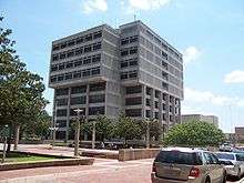
The parish courthouse in Baton Rouge is one of twenty-six public buildings constructed by the contractor George A. Caldwell[4] In the 1930s.
In 2010, the 19th Judicial District Court moved into the new courthouse on North Blvd.[5]
Demographics
| Historical population | |||
|---|---|---|---|
| Census | Pop. | %± | |
| 1810 | 1,468 | — | |
| 1820 | 5,220 | 255.6% | |
| 1830 | 6,698 | 28.3% | |
| 1840 | 8,133 | 21.4% | |
| 1850 | 11,977 | 47.3% | |
| 1860 | 16,046 | 34.0% | |
| 1870 | 17,816 | 11.0% | |
| 1880 | 19,966 | 12.1% | |
| 1890 | 25,922 | 29.8% | |
| 1900 | 31,153 | 20.2% | |
| 1910 | 34,580 | 11.0% | |
| 1920 | 44,513 | 28.7% | |
| 1930 | 68,208 | 53.2% | |
| 1940 | 88,415 | 29.6% | |
| 1950 | 158,236 | 79.0% | |
| 1960 | 230,058 | 45.4% | |
| 1970 | 285,167 | 24.0% | |
| 1980 | 366,191 | 28.4% | |
| 1990 | 380,105 | 3.8% | |
| 2000 | 412,852 | 8.6% | |
| 2010 | 440,171 | 6.6% | |
| Est. 2015 | 446,753 | [6] | 1.5% |
| U.S. Decennial Census[7] 1790-1960[8] 1900-1990[9] 1990-2000[10] 2010-2013[1] | |||
As of the 2010 census,[11] there were over 440,000 residents in East Baton Rouge, making it the largest parish in Louisiana.[12] There are 156,365 households and 102,575 families residing in the parish. The population density was 906 people per square mile (350/km²). There were 169,073 housing units at an average density of 371 per square mile (143/km²). The racial makeup of the parish was 49.5% White, 45.9% Black or African American, 0.3% Native American, 3.0% Asian, 0.12% Pacific Islander, 1.02% from other races, and 1.2% from two or more races. 3.8% of the population were Hispanic or Latino of any race.
There were 156,365 households, of which 32.80% include children under the age of 18. 44.70% were married couples living together, 16.80% had a female householder with no husband present, and 34.40% were non-families. 26.90% of all households were made up of individuals and 7.20% had someone living alone who was 65 years of age or older. The average household size was 2.55 and the average family size was 3.14.
In the parish the population was spread out with 26.20% under the age of 18, 14.40% aged 18 to 24, 28.70% from 25 to 44, 20.80% from 45 to 64, and 9.90% who were 65 years of age or older. The median age was 32 years old. For every 100 females there were 91.90 males. For every 100 females age 18 and over, there were 87.50 males.
The median income for a parish household was $37,224, and the median income for a family was $47,480. Males had a median income of $38,334 versus $25,073 for females. The per capita income for the parish was $19,790. About 13.20% of families and 17.90% of the population were below the poverty line, including 22.70% of those under age 18 and 11.50% of those age 65 or over.
East Baton Rouge Parish has both the highest high school graduation rate, at 82.2%, and the highest percentage of residents holding at least a bachelor's degree, 33.3%, in the state of Louisiana.[13]
Politics
Since 1980, East Baton Rouge Parish has been a bellwether in presidential elections, voting for the winner of the presidency in all but one election (it voted for George H.W. Bush in 1992) but not necessarily the winner of Louisiana. The 2008 presidential election helped keep the parish's status as a bellwether because Democrat Barack Obama won 51% of the vote and 99,652 votes. Republican John McCain won 48% of the votes and 95,390 votes. In the 2008 Senate election, Democrat Mary Landrieu who kept her job as a U.S Senator won 57% of the vote and 110,694 votes in East Baton Rouge Parish. Republican John Neely Kennedy won 41% of the vote and 80,222 votes. In the 2004 presidential election, East Baton Rouge Parish cast the majority of its votes to Republican George W. Bush who won 54% of the votes and 99,943 votes. Democrat John F. Kerry won 45% of the votes and 82,298 votes.[14]
Education
Sections of the parish not in Baker, Zachary, or the City of Central are zoned to schools in East Baton Rouge Parish School System.[15]
Baker residents attend the City of Baker School System.[16]
Zachary residents attend the Zachary Community School Board.[17]
Central residents attend the Central Community School System[18] schools.
Law enforcement
- East Baton Rouge Parish Sheriff's Office
- Baton Rouge Police Department
- Baton Rouge City Constable (Ward 1)
- Baton Rouge Metropolitan Airport Police Department
- Baker Police Department
- Baker City Marshall
- Zachary Police Department
- City of Central Police Department
- Louisiana State University Police Department
- Baton Rouge Community College Police Department
- Southern University Police Department
- East Baton Rouge Parish Constable - Ward 2, District 1
- East Baton Rouge Parish Constable - Ward 2, District 2
- East Baton Rouge Parish Constable - Ward 2, District 3
- East Baton Rouge Parish Constable - Ward 3, District 1
- East Baton Rouge Parish Constable - Ward 3, District 2
- East Baton Rouge Parish Constable - Ward 3, District 3
National Guard
The 769th Engineer Battalion (Combat) a unit of the 225th Engineer Brigade is located in East Baton Rouge Parish. Two companies of this battalion deployed to Iraq in 2007-2008. Another company sized unit, the 927TH Sapper Company deployed to Afghanistan in 2008-2009. As of 2011 yet another company, the 926TH MAC (Mobility Augmentation Company) located in Baker, Louisiana has been alerted for overseas deployment. The 769th Engineers has two other companies, the 922nd Horizontal Engineer Company located in Gonzales, Louisiana and the 928th Sapper Company located in Napoleonville, Louisiana.
Communities
Cities
Census-designated places
- Brownfields
- Gardere
- Inniswold
- Merrydale
- Monticello
- Oak Hills Place
- Old Jefferson
- Shenandoah
- Village St. George
- Westminster
Unincorporated communities
See also
- East Baton Rouge Parish Sheriff's Office
- National Register of Historic Places listings in East Baton Rouge Parish, Louisiana
References
- 1 2 "State & County QuickFacts". United States Census Bureau. Retrieved August 9, 2013.
- ↑ "Find a County". National Association of Counties. Retrieved 2011-06-07.
- ↑ "2010 Census Gazetteer Files". United States Census Bureau. August 22, 2012. Retrieved August 20, 2014.
- ↑ "Caldwell, George A.". Louisiana Historical Association, A Dictionary of Louisiana Biography (lahistory.org). Retrieved December 21, 2010.
- ↑ WAFB New courthouse to open soon
- ↑ "County Totals Dataset: Population, Population Change and Estimated Components of Population Change: April 1, 2010 to July 1, 2015". Retrieved July 2, 2016.
- ↑ "U.S. Decennial Census". United States Census Bureau. Retrieved August 20, 2014.
- ↑ "Historical Census Browser". University of Virginia Library. Retrieved August 20, 2014.
- ↑ "Population of Counties by Decennial Census: 1900 to 1990". United States Census Bureau. Retrieved August 20, 2014.
- ↑ "Census 2000 PHC-T-4. Ranking Tables for Counties: 1990 and 2000" (PDF). United States Census Bureau. Retrieved August 20, 2014.
- ↑ "American FactFinder". United States Census Bureau. Retrieved 2008-01-31.
- ↑ http://www.fox8live.com/news/local/story/Census-New-Orleans-population-lower-than-expected/aBh8yvkxVkejwK1Nly5zJQ.cspx
- ↑ http://www.census.gov/acs/www/Products/Ranking/index.htm
- ↑ http://www.uselectionatlas.org/RESULTS/statesub.php?year=2004&fips=22033&f=1&off=0&elect=0
- ↑ http://www.ebrpss.k12.la.us/
- ↑ http://bakerschools.org/main.cfm
- ↑ http://www.zacharyschools.org/
- ↑ http://www.centralcsd.org/
External links
- Baton Rouge City and Parish government's website
- Visit Baton Rouge
- Explore the History and Culture of Southeastern Louisiana, a National Park Service Discover Our Shared Heritage Travel Itinerary
Geology and Geological Hazards
- Heinrich, P. V., and W. J. Autin, 2000, Baton Rouge 30 x 60 minute geologic quadrangle. Louisiana Geological Survey, Baton Rouge, Louisiana.
- McCulloh, R. P., 2001, Active Faults in East Baton Rouge Parish, Louisiana. Public Information Series, no. 8, Louisiana Geological Survey, Baton Rouge, Louisiana.
- McCulloh, R. P., 2008a, The Scotlandville, Denham Springs, and Baton Rouge Faults — A Map Guide for Real Estate Buyers, Sellers, and Developers in the Greater Baton Rouge Area. Public Information Series, no. 13, Louisiana Geological Survey, Baton Rouge, Louisiana.
- McCulloh, R. P., 2008b, Field Trip Guide to Selected Locations Along the Baton Rouge Fault Trace Spanning the Pleistocene–Holocene Transition in Western East Baton Rouge Parish. Public Information Series, no. 8, Louisiana Geological Survey, Baton Rouge, Louisiana.
 |
West Feliciana Parish | East Feliciana Parish | St. Helena Parish | |
| West Baton Rouge Parish | |
Livingston Parish | ||
| ||||
| | ||||
| Iberville Parish | Ascension Parish |
Municipalities and communities of East Baton Rouge Parish, Louisiana, United States | ||
|---|---|---|
| Cities | 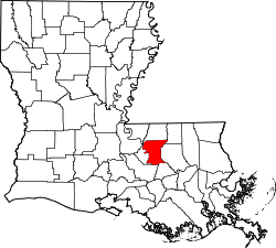 | |
| CDPs | ||
| Unincorporated communities | ||
Coordinates: 30°32′N 91°05′W / 30.54°N 91.09°W