Burke, Vermont
| Burke, Vermont | |
|---|---|
| Town | |
 | |
 Burke, Vermont | |
 Burke, Vermont Location in the United States | |
| Coordinates: 44°36′56″N 71°57′15″W / 44.61556°N 71.95417°WCoordinates: 44°36′56″N 71°57′15″W / 44.61556°N 71.95417°W | |
| Country | United States |
| State | Vermont |
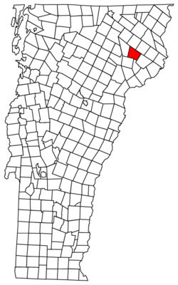
| County | Caledonia |
| Chartered | 1782 |
| Settled | 1790 |
| Organized | 1796 |
| Area | |
| • Total | 34.0 sq mi (88.1 km2) |
| • Land | 33.9 sq mi (87.8 km2) |
| • Water | 0.2 sq mi (0.4 km2) |
| Elevation | 1,027 ft (313 m) |
| Population (2010) | |
| • Total | 1,753 |
| • Density | 52/sq mi (20.0/km2) |
| Time zone | Eastern (EST) (UTC-5) |
| • Summer (DST) | EDT (UTC-4) |
| ZIP code | 05871 |
| Area code(s) | 802 |
| FIPS code | 50-10450[1] |
| GNIS feature ID | 1462059[2] |
| Website |
www |
Burke is a town in Caledonia County, Vermont, United States. The population was 1,753 at the 2010 census.[3] The town contains the villages of East Burke, West Burke and Burke Hollow.
Etymology
The town was named for Sir Edmund Burke, a member of the English Parliament.[4]
Geography
According to the United States Census Bureau, the town has a total area of 34.0 square miles (88.1 km2), of which 33.9 square miles (87.8 km2) is land and 0.15 square miles (0.4 km2), or 0.40%, is water.[3]
Burke is bordered by the towns of Lyndon and Kirby to the south, Victory to the southeast, East Haven to the northeast, Newark to the north, and Sutton to the west. U.S. Route 5 runs through the western part of the town, connecting Lyndonville to the south with Barton and Newport to the north. Vermont Route 5A leaves US-5 in the village of West Burke, leading north past Lake Willoughby to Derby. Vermont Route 114 runs through East Burke, leading north to Island Pond and south to US-5 in Lyndonville.
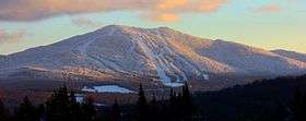
The highest point in town is Burke Mountain, at 3,271 feet (997 m).
Demographics
| Historical population | |||
|---|---|---|---|
| Census | Pop. | %± | |
| 1800 | 108 | — | |
| 1810 | 460 | 325.9% | |
| 1820 | 541 | 17.6% | |
| 1830 | 866 | 60.1% | |
| 1840 | 997 | 15.1% | |
| 1850 | 1,103 | 10.6% | |
| 1860 | 1,138 | 3.2% | |
| 1870 | 1,162 | 2.1% | |
| 1880 | 1,252 | 7.7% | |
| 1890 | 1,198 | −4.3% | |
| 1900 | 1,184 | −1.2% | |
| 1910 | 1,183 | −0.1% | |
| 1920 | 1,041 | −12.0% | |
| 1930 | 1,016 | −2.4% | |
| 1940 | 998 | −1.8% | |
| 1950 | 1,042 | 4.4% | |
| 1960 | 922 | −11.5% | |
| 1970 | 1,053 | 14.2% | |
| 1980 | 1,385 | 31.5% | |
| 1990 | 1,406 | 1.5% | |
| 2000 | 1,571 | 11.7% | |
| 2010 | 1,753 | 11.6% | |
| Est. 2014 | 1,735 | [5] | −1.0% |
| U.S. Decennial Census[6] | |||
As of the census[1] of 2000, there were 1,571 people, 641 households, and 455 families residing in the town. The population density was 46.1 people per square mile (17.8/km2). There were 892 housing units at an average density of 26.2 per square mile (10.1/km2). The racial makeup of the town was 97.14% White, 0.25% African American, 0.57% Native American, 0.19% Asian, 0.38% from other races, and 1.46% from two or more races. Hispanic or Latino of any race were 1.08% of the population.
There were 641 households out of which 30.4% had children under the age of 18 living with them, 58.0% were married couples living together, 9.8% had a female householder with no husband present, and 29.0% were non-families. 21.7% of all households were made up of individuals and 5.8% had someone living alone who was 65 years of age or older. The average household size was 2.45 and the average family size was 2.83.
In the town the population was spread out with 23.6% under the age of 18, 8.0% from 18 to 24, 28.8% from 25 to 44, 28.3% from 45 to 64, and 11.4% who were 65 years of age or older. The median age was 39 years. For every 100 females there were 108.6 males. For every 100 females age 18 and over, there were 102.7 males.
Economy
Personal income
The median income for a household in the town was $35,268, and the median income for a family was $41,563. Males had a median income of $28,977 versus $19,509 for females. The per capita income for the town was $20,697. About 11.7% of families and 13.9% of the population were below the poverty line, including 18.0% of those under age 18 and 13.8% of those age 65 or over. Burke has the highest per capita income of any place in Caledonia County or the Northeast Kingdom.
Tourism
Burke Mountain Ski Area is on Burke Mountain. A volunteer group maintains the mountain biking trails. Portions of these trails are open to cross-country skiers in the winter.
East Burke is home to the Kingdom Trails trail system. Mountain bikers frequent the trails in the summer and autumn, during which there are hundreds of riders at any given time riding the local trails.[7]
Notable people
- Buddy Jones, Bluegrass musician and music recorder/distributor; resided in West Burke (1980-2014)
- Charles Albert Woodruff, US Army brigadier-general; born in Burke (1845)[8]
References
- 1 2 "American FactFinder". United States Census Bureau. Archived from the original on 2013-09-11. Retrieved 2008-01-31.
- ↑ "US Board on Geographic Names". United States Geological Survey. 2007-10-25. Retrieved 2008-01-31.
- 1 2 "Geographic Identifiers: 2010 Demographic Profile Data (G001): Burke town, Caledonia County, Vermont". U.S. Census Bureau, American Factfinder. Retrieved February 4, 2013.
- ↑ Lawson, Kenneth (April 2013). "A Career of Successful Military Service: Brigadier General Charles A. Woodruff of Burke, Vermont". Vermont's Northland Journal. 12 (1): 27–32.
- ↑ "Annual Estimates of the Resident Population for Incorporated Places: April 1, 2010 to July 1, 2014". Retrieved June 4, 2015.
- ↑ "U.S. Decennial Census". United States Census Bureau. Archived from the original on May 11, 2015. Retrieved May 16, 2015.
- ↑ Tierney, Tim. "Kingdom Trails Association, events". Retrieved 20 October 2011.
- ↑ Class of 1899 Biographies Archived January 14, 2009, at the Wayback Machine.
External links
Municipalities and communities of Caledonia County, Vermont, United States | ||
|---|---|---|
| Towns | 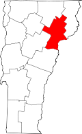 | |
| Villages | ||
| CDPs | ||
| Other community | ||