Newark, Vermont
| Newark, Vermont | |
|---|---|
| Town | |
 Newark, Vermont | |
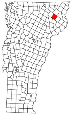
 Newark, Vermont Location in the United States | |
| Coordinates: 44°42′8″N 71°56′34″W / 44.70222°N 71.94278°WCoordinates: 44°42′8″N 71°56′34″W / 44.70222°N 71.94278°W | |
| Country | United States |
| State | Vermont |
| County | Caledonia |
| Area | |
| • Total | 37.2 sq mi (96.4 km2) |
| • Land | 36.8 sq mi (95.2 km2) |
| • Water | 0.5 sq mi (1.2 km2) |
| Elevation | 1,319 ft (402 m) |
| Population (2010) | |
| • Total | 581 |
| • Density | 16/sq mi (6.1/km2) |
| Time zone | Eastern (EST) (UTC-5) |
| • Summer (DST) | EDT (UTC-4) |
| ZIP code | 05871 |
| Area code(s) | 802 |
| FIPS code | 50-47725[1] |
| GNIS feature ID | 1462157[2] |
Newark is a town in Caledonia County, Vermont, United States. The population was 581 at the 2010 census.[3]
Geography
Newark is located at the northern tip of Caledonia County, Vermont. It is bordered by the town of Burke to the south, Sutton to the west, Westmore to the northwest, Brighton to the north, Ferdinand to the northeast, and East Haven to the southeast. According to the United States Census Bureau, the town has a total area of 37.2 square miles (96.4 km2), of which 36.8 square miles (95.2 km2) is land and 0.46 square miles (1.2 km2), or 1.25%, is water.[3]
Vermont Route 114 passes through the town, leading north to Island Pond in the town of Brighton and south to Lyndonville. Vermont Route 5A crosses the western corner of Newark, leading north past Lake Willoughby to Derby and south to U.S. Route 5 in West Burke.
The highest point in Newark is an unnamed 2,362-foot (720 m) summit near the northwest border with Westmore, west of Abbott Hill Road.[4]
Demographics
| Historical population | |||
|---|---|---|---|
| Census | Pop. | %± | |
| 1800 | 8 | — | |
| 1810 | 88 | 1,000.0% | |
| 1820 | 154 | 75.0% | |
| 1830 | 257 | 66.9% | |
| 1840 | 360 | 40.1% | |
| 1850 | 434 | 20.6% | |
| 1860 | 567 | 30.6% | |
| 1870 | 593 | 4.6% | |
| 1880 | 679 | 14.5% | |
| 1890 | 536 | −21.1% | |
| 1900 | 500 | −6.7% | |
| 1910 | 415 | −17.0% | |
| 1920 | 364 | −12.3% | |
| 1930 | 301 | −17.3% | |
| 1940 | 242 | −19.6% | |
| 1950 | 192 | −20.7% | |
| 1960 | 151 | −21.4% | |
| 1970 | 144 | −4.6% | |
| 1980 | 280 | 94.4% | |
| 1990 | 354 | 26.4% | |
| 2000 | 470 | 32.8% | |
| 2010 | 581 | 23.6% | |
| Est. 2014 | 581 | [5] | 0.0% |
| U.S. Decennial Census[6] | |||
As of the census[1] of 2000, there were 470 people, 19 households, and 12 families residing in the town. The population density was 1.8 people per square mile (4.9/km2). There were 449 housing units at an average density of .2 per square mile (4.7/km2). The racial makeup of the town was 98.94% White, 0.2% African American, 0.64% Native American and 0.21% Asian. Hispanic or Latino of any race were 0.43% of the population.
There were 191 households out of which 29.3% had children under the age of 18 living with them, 50.8% were married couples living together, 11.0% had a female householder with no husband present, and 32.5% were non-families. 24.6% of all households were made up of individuals and 9.4% had someone living alone who was 65 years of age or older. The average household size was 2.46 and the average family size was 2.94.
In the town, the population was spread out with 27.0% under the age of 18, 4.5% from 18 to 24, 29.4% from 25 to 44, 27.7% from 45 to 64, and 11.5% who were 65 years of age or older. The median age was 39 years. For every 100 females there were 94.2 males. For every 100 females age 18 and over, there were 105.4 males.
The median income for a household in the town was $33,611, and the median income for a family was $46,250. Males had a median income of $33,229 versus $22,045 for females. The per capita income for the town was $18,035. About 9.8% of families and 17.6% of the population were below the poverty line, including 19.8% of those under age 18 and 28.0% of those age 65 or over.
School
The K-8 school has about 70 students.
- Newark Street School located at 1448 Newark Street, Newark, VT 05871[7]
References
- 1 2 "American FactFinder". United States Census Bureau. Retrieved 2008-01-31.
- ↑ "US Board on Geographic Names". United States Geological Survey. 2007-10-25. Retrieved 2008-01-31.
- 1 2 "Geographic Identifiers: 2010 Demographic Profile Data (G001): Newark town, Caledonia County, Vermont". U.S. Census Bureau, American Factfinder. Retrieved February 6, 2013.
- ↑ U.S. Geological Survey West Burke, VT 7.5-minute quadrangle, 1988.
- ↑ "Annual Estimates of the Resident Population for Incorporated Places: April 1, 2010 to July 1, 2014". Retrieved June 4, 2015.
- ↑ "U.S. Decennial Census". United States Census Bureau. Retrieved May 16, 2015.
- ↑ http://newark.cnsuschools.org/home
Municipalities and communities of Caledonia County, Vermont, United States | ||
|---|---|---|
| Towns | 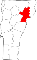 | |
| Villages | ||
| CDPs | ||
| Other community | ||