Burke Mountain (Vermont)
| Burke Mountain | |
|---|---|
 | |
| Highest point | |
| Elevation | 3,270 ft (1,000 m) [1] |
| Prominence | 1,600 ft (490 m) [2] |
| Coordinates | 44°34.25′N 71°53.59′W / 44.57083°N 71.89317°WCoordinates: 44°34.25′N 71°53.59′W / 44.57083°N 71.89317°W |
| Geography | |
| Location | Northeast Kingdom, Vermont, U.S. |
| Topo map | USGS Burke Mountain |
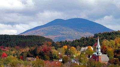
Burke Mountain is a mountain located in the "Northeast Kingdom" of Vermont. The bulk of the mountain is in Caledonia County, but its southeast side is in Essex County. It is flanked to the east by Umpire Mountain.
Burke Mountain stands within the watershed of the Passumpsic River. The northeast and northwest sides of Burke Mountain drain into Dish Mill Brook, thence into the East Branch of the Passumpsic River. The southwest end of Burke Mtn. drains into Mountain Brook, thence into the East Branch of the Passumpsic River. The south slopes and southeast side of Burke Mountain drain into Weir Mill Brook, thence into Bog Brook, the Moose River, and the Passumpsic River.
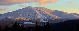
It is within the Darling State Forest Park of Victory State Forest. The Burke Mountain Ski Area has been developed on the northwest slopes of the mountain. [3] Burke Mountain was purchased by the owners of Jay Peak Resort in Jay Vermont.
Weather
Burke's average annual snowfall is 217 inches (5,500 mm).[4]
Skiing
Burke Mountain Resort has 55 ski trails and 15 glades with 270 acres (110 ha) skiable of terrain and over 100 acres (40 ha) of glades. Among the 55 trails, 11% are designated "Green Circle" (Beginner trails), 47% are "Blue Square" (Intermediate), 33% are "Black Diamond" (Advanced), and 9% are "Double Black Diamond" (Expert).[5] Burke also features three terrain parks. Two of the terrain parks are featured on the lower mountain, (Dashney Mile and Carter Country), with the remaining park (Open Slope) located above the Mid-Burke Lodge.
Burke Mountain Resort has a vertical drop of 2,011 feet (613 m) and has 80% snowmaking. The mountain is serviced by 6 lifts: 2 high speed quads, 1 fixed grip quad and 3 surface lifts.[6][7]
The Burke Mountain Academy is located there.
Other mountain activities
In wintertime, there are miles of ski-able terrain throughout the NEK (Northeast Kingdom). Burke Mountain is also located on the Vermont Association of Snow Travelers trails, making the resort accessible by snowmobile. Snowmobile rentals are available in the area. Snow biking is done on the Kingdom Trails Nordic trails.[8]
In summertime, there is singletrack biking, Burke Bike Park, hiking, Hang Gliding, Paragliding,[9] golfing, swimming, climbing, horseback riding, canoeing, kayaking, and fishing.[10]

See also
Notes
- ↑ Summit elevation between 3,260 and 3,280 ft.
- ↑ Key col elevation between 1,660 and 1,680 ft.
- ↑ McGilvery, Keith. "Jay Peak owners buy Burke Mountain". wcax. Retrieved 23 June 2013.
- ↑ Skiburke.com Mountain Archived January 16, 2010, at the Wayback Machine.
- ↑ Alpine skiing
- ↑ Skiburke.com Mountain Archived January 16, 2010, at the Wayback Machine.
- ↑ Q Burke Mountain Resort Trail map. Archived March 10, 2016, at the Wayback Machine.
- ↑ www.kingdomtrails.org
- ↑ http://www.vhga.aero/sites/1
- ↑ skiburke.com/the-mountain/ Archived April 29, 2013, at the Wayback Machine.
External links
- Skiburke.com
- BurkeVermont.com
- U.S. Geological Survey Geographic Names Information System: Burke Mountain