Burke Mountain Ski Area
| Burke Mountain | |
|---|---|
 | |
| Location | East Burke, Vermont |
| Nearest city | Lyndonville |
| Coordinates | 44°34′12″N 71°53′42″W / 44.57°N 71.895°WCoordinates: 44°34′12″N 71°53′42″W / 44.57°N 71.895°W |
| Vertical | 2,011 ft (613 m) |
| Top elevation | 3,267 ft (996 m) |
| Base elevation | 1,256 ft (383 m) |
| Skiable area | 250 acres (100 ha) |
| Runs | 55 |
| Longest run | 0.9 miles (1.4 km) |
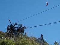
| Lift system |
2 high-speed quads 1 fixed-grip quad 1 J-bar (surface) 1 high-speed POMA (surface) |
| Terrain parks |
Small Advanced Park (Large hits and Rails) on Open Slope (Upper Mtn.) Intermediate Park (Jumps, Rails, Boxes) on Dashney Mile (Lower Mtn.) Beginner Park (Small hits, Berms) on Bunker Hill (Lower Mtn.) |
| Snowfall | 217 in (550 cm) |
| Snowmaking | 200 acres (81 ha) |
| Website | skiburke.com |
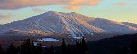
Burke Mountain Ski resort is a mid-size ski resort open to skiing and snowboarding in northeast Vermont (aka Vermont's "Northeast Kingdom" ). It is located on Burke Mountain, and is home to Burke Mountain Academy, a ski academy.
In May 2012, Burke Mountain Resort was purchased by the owners of nearby Jay Peak Resort.[1] The new ownership has improved Burke's snow making capability for the 2012-2013 ski season. There are plans to build several slopeside hotels/lodges in the near future (one hotel/lodge is currently under construction near the Mid-Burke part of the ski area).
General description
The ski area has two main sections of terrain.
The "Lower Mountain" consists of mostly Beginner terrain and is accessed by a high-speed detachable quad chairlift. There is also a "Bunny Slope" accessed by a J-bar surface lift. A beginner carpet lift was installed in 2010 to make the learning progression easier for first time skiers. There are a couple of terrain parks and a beginner glade (Enchanted Forest) here as well. This section of the mountain also has lift served mountain biking during non-snow months. The main Sherburne Base Lodge services this section of the resort. This lodge contains the rental shop, restaurant/bar, retail shop, and cafeteria.
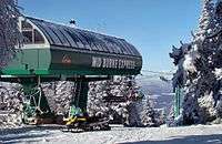
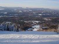
The "Upper Mountain" consists of predominantly Intermediate and Advanced terrain. Trails on the upper mountain are accessed via two lifts, a high-speed Poma surface lift and a high-speed quad chairlift (Mid-Burke Express), installed for the 2011–2012 season.[2] The fixed grip "Willoughby" quad summit lift is still functional and is called into service on busy days. Trails vary from wide open groomed runs (Upper/Lower Dipper, Upper/Lower Willoughby), to steep ungroomed trails (Doug's Drop), to glades (Caveman, Throbulator, Jungle). The major trail visible from the Mid-Lodge (Upper/Lower Warren's Way) is the main training trail for Burke Mountain Academy and other local racing organizations. The intermediate/expert East Bowl trail is considered to be a signature "old New England style" trail due to its long, narrow, winding nature. There is a long traverse to and from this trail that comes with a "not snowboarder friendly" advisory. There is one "easy way" down the upper mountain via the "Deer Run" (formally "The Toll Road") trail (this is the auto toll road in the summer). This trail was reclassified from a beginner to an intermediate trail in the early 2000s due to the many intersections with a widened Super GS slope. The Mid-Burke Lodge services this section of the resort. This lodge contains a bar and a cafeteria.
Summer Activities
Summer activities include: Lift served downhill mountain biking on 7 purpose built trails featuring constructed jumps and berms. The lower mountain trails are accessed from the base lodge using the Sherburne Express Quad lift. [3] The upper mountain has several expert mountain bike trails that are accessed by driving the toll road or riding up the road. These trails are not lift served.
When the correct atmospheric conditions present themselves, Burke is also a popular location for Hang Gliding and Paragliding.
References
- ↑ http://www.wcax.com/story/18614019/burke-mountain-sold
- ↑ "Vermont Ski Resorts Upgrade for 2011-12 Season". First Tracks!! Online. 29 September 2011. Archived from the original on 1 October 2011. Retrieved 1 October 2011.
- ↑ http://www.skiburke.com/the-mountain/summer/mountain-biking/