Walden, Vermont
| Walden, Vermont | |
|---|---|
| Town | |
|
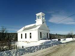
Walden United Methodist Church | |
 Walden, Vermont | |
 Walden, Vermont Location in the United States | |
| Coordinates: 44°28′48″N 72°14′46″W / 44.48000°N 72.24611°WCoordinates: 44°28′48″N 72°14′46″W / 44.48000°N 72.24611°W | |
| Country | United States |
| State | Vermont |
| County | Caledonia |
| Area | |
| • Total | 39.0 sq mi (100.9 km2) |
| • Land | 38.6 sq mi (99.9 km2) |
| • Water | 0.3 sq mi (0.9 km2) |
| Elevation | 1,683 ft (513 m) |
| Population (2010) | |
| • Total | 935 |
| • Density | 24/sq mi (9.4/km2) |
| Time zone | Eastern (EST) (UTC-5) |
| • Summer (DST) | EDT (UTC-4) |
| ZIP code | 05873 |
| Area code(s) | 802 |
| FIPS code | 50-75700[1] |
| GNIS feature ID | 1462238[2] |
Walden is a town in Caledonia County, Vermont, United States. The population was 935 at the 2010 census.[3] The community has no ZIP code of its own; mail is routed through the West Danville and East Hardwick post offices.[4]
Geography
According to the United States Census Bureau, the town has a total area of 39.0 square miles (100.9 km2), of which 38.6 square miles (99.9 km2) is land and 0.35 square miles (0.9 km2), or 0.91%, is water.[3] Vermont Route 15 passes through the town, leading west to Hardwick and Morrisville and east to Danville. It is 17 miles (27 km) east via VT 15 and U.S. Route 2 to St. Johnsbury, Vermont.
The highest point in Walden is the summit of Stannard Mountain, near the town's northern border, with an elevation of over 2,579 feet (786 m) above sea level.[5]
Demographics
| Historical population | |||
|---|---|---|---|
| Census | Pop. | %± | |
| 1790 | 11 | — | |
| 1800 | 153 | 1,290.9% | |
| 1810 | 455 | 197.4% | |
| 1820 | 580 | 27.5% | |
| 1830 | 827 | 42.6% | |
| 1840 | 913 | 10.4% | |
| 1850 | 910 | −0.3% | |
| 1860 | 1,099 | 20.8% | |
| 1870 | 992 | −9.7% | |
| 1880 | 931 | −6.1% | |
| 1890 | 810 | −13.0% | |
| 1900 | 764 | −5.7% | |
| 1910 | 739 | −3.3% | |
| 1920 | 674 | −8.8% | |
| 1930 | 664 | −1.5% | |
| 1940 | 547 | −17.6% | |
| 1950 | 481 | −12.1% | |
| 1960 | 427 | −11.2% | |
| 1970 | 442 | 3.5% | |
| 1980 | 575 | 30.1% | |
| 1990 | 703 | 22.3% | |
| 2000 | 782 | 11.2% | |
| 2010 | 935 | 19.6% | |
| Est. 2014 | 933 | [6] | −0.2% |
| U.S. Decennial Census[7] | |||
As of the census[1] of 2000, there were 782 people, 301 households, and 219 families residing in the town. The population density was 20.2 people per square mile (7.8/km2). There were 499 housing units at an average density of 12.9 per square mile (5.0/km2). The racial makeup of the town was 98.21% White, 0.51% African American, 0.13% Native American, 0.13% from other races, and 1.02% from two or more races. Hispanic or Latino of any race were 0.26% of the population.
There were 301 households out of which 39.5% had children under the age of 18 living with them, 58.5% were married couples living together, 12.0% had a female householder with no husband present, and 27.2% were non-families. 22.9% of all households were made up of individuals and 7.6% had someone living alone who was 65 years of age or older. The average household size was 2.60 and the average family size was 3.04.
In the town the population was spread out with 28.5% under the age of 18, 6.1% from 18 to 24, 30.1% from 25 to 44, 25.4% from 45 to 64, and 9.8% who were 65 years of age or older. The median age was 36 years. For every 100 females there were 100.0 males. For every 100 females age 18 and over, there were 99.6 males.
The median income for a household in the town was $37,500, and the median income for a family was $40,625. Males had a median income of $29,625 versus $21,875 for females. The per capita income for the town was $17,253. About 5.4% of families and 7.8% of the population were below the poverty line, including 10.1% of those under age 18 and 6.0% of those age 65 or over.
Notable people
- Frank Livingston Underwood (1844-1918), banker, copper magnate, railroad founder
References
- 1 2 "American FactFinder". United States Census Bureau. Retrieved 2008-01-31.
- ↑ "US Board on Geographic Names". United States Geological Survey. 2007-10-25. Retrieved 2008-01-31.
- 1 2 "Geographic Identifiers: 2010 Demographic Profile Data (G001): Walden town, Caledonia County, Vermont". U.S. Census Bureau, American Factfinder. Retrieved February 6, 2013.
- ↑ Zip Code Lookup
- ↑ U.S. Geological Survey Stannard, VT 7.5-minute quadrangle, 1986.
- ↑ "Annual Estimates of the Resident Population for Incorporated Places: April 1, 2010 to July 1, 2014". Retrieved June 4, 2015.
- ↑ "U.S. Decennial Census". United States Census Bureau. Retrieved May 16, 2015.
External links
Municipalities and communities of Caledonia County, Vermont, United States | ||
|---|---|---|
| Towns | 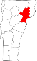 | |
| Villages | ||
| CDPs | ||
| Other community | ||