Lannon, Wisconsin
| Lannon, Wisconsin | |
|---|---|
| Village | |
 Location in Waukesha County and the state of Wisconsin. | |
| Coordinates: 43°9′1″N 88°9′52″W / 43.15028°N 88.16444°WCoordinates: 43°9′1″N 88°9′52″W / 43.15028°N 88.16444°W | |
| Country | United States |
| State | Wisconsin |
| County | Waukesha |
| Area[1] | |
| • Total | 2.46 sq mi (6.37 km2) |
| • Land | 2.44 sq mi (6.32 km2) |
| • Water | 0.02 sq mi (0.05 km2) |
| Elevation[2] | 915 ft (279 m) |
| Population (2010)[3] | |
| • Total | 1,107 |
| • Estimate (2012[4]) | 1,098 |
| • Density | 453.7/sq mi (175.2/km2) |
| Time zone | Central (CST) (UTC-6) |
| • Summer (DST) | CDT (UTC-5) |
| FIPS code | 55-42450[5] |
| GNIS feature ID | 1567839[2] |
Lannon is a village in Waukesha County, Wisconsin, United States. The population was 1,107 at the 2010 census.
History
The village is named for William Lannon, who settled here with his bride in 1834.[6][7] Lannon is what Lannon stone, a type of limestone or dolomite, is named for, as it was quarried here.
Lannon stone
John Halquist built one of the state's largest stone companies from Lannon stone first in Sussex, Wisconsin and then in multiple locations.[8]
Lannon stone was the major source of stone for many cities in Wisconsin and was a major source for Chicago, too. It was widely used to provide a stone veneer on bridges.[9]
Lannon stone is variously asserted to be limestone distinct from dolomite, or to be limestone which is also known as dolomite.[10]
Menonomee Park has been named as an excellent place to photograph Lannon stone.[10]
Geography
Lannon is located at 43°9′1″N 88°9′52″W / 43.15028°N 88.16444°W (43.150288, -88.164568).[11]
According to the United States Census Bureau, the village has a total area of 2.46 square miles (6.37 km2), of which, 2.44 square miles (6.32 km2) of it is land and 0.02 square miles (0.05 km2) is water.[1]
Demographics
| Historical population | |||
|---|---|---|---|
| Census | Pop. | %± | |
| 1930 | 434 | — | |
| 1940 | 378 | −12.9% | |
| 1950 | 438 | 15.9% | |
| 1960 | 1,084 | 147.5% | |
| 1970 | 1,056 | −2.6% | |
| 1980 | 987 | −6.5% | |
| 1990 | 924 | −6.4% | |
| 2000 | 1,009 | 9.2% | |
| 2010 | 1,107 | 9.7% | |
| Est. 2015 | 1,086 | [12] | −1.9% |
2010 census
As of the census[3] of 2010, there were 1,107 people, 479 households, and 314 families residing in the village. The population density was 453.7 inhabitants per square mile (175.2/km2). There were 517 housing units at an average density of 211.9 per square mile (81.8/km2). The racial makeup of the village was 94.8% White, 1.0% African American, 0.6% Native American, 0.5% Asian, 1.7% from other races, and 1.4% from two or more races. Hispanic or Latino of any race were 4.0% of the population.
There were 479 households of which 26.5% had children under the age of 18 living with them, 48.6% were married couples living together, 10.0% had a female householder with no husband present, 6.9% had a male householder with no wife present, and 34.4% were non-families. 29.2% of all households were made up of individuals and 8.8% had someone living alone who was 65 years of age or older. The average household size was 2.31 and the average family size was 2.82.
The median age in the village was 43.2 years. 21.1% of residents were under the age of 18; 5.7% were between the ages of 18 and 24; 25.4% were from 25 to 44; 33.1% were from 45 to 64; and 14.7% were 65 years of age or older. The gender makeup of the village was 50.1% male and 49.9% female.
2000 census
As of the census[5] of 2000, there were 1,009 people, 425 households, and 282 families residing in the village. The population density was 413.0 people per square mile (159.7/km²). There were 434 housing units at an average density of 177.7 per square mile (68.7/km²). The racial makeup of the village was 97.92% White, 0.50% African American, 0.40% Native American, 0.10% Asian, 0.10% from other races, and 0.99% from two or more races. Hispanic or Latino of any race were 1.59% of the population.
There were 425 households out of which 27.1% had children under the age of 18 living with them, 55.3% were married couples living together, 6.4% had a female householder with no husband present, and 33.6% were non-families. 29.2% of all households were made up of individuals and 9.4% had someone living alone who was 65 years of age or older. The average household size was 2.37 and the average family size was 2.95.
In the village, the population ages were spread out with 22.9% under the age of 18, 5.9% from 18 to 24, 29.8% from 25 to 44, 27.8% from 45 to 64, and 13.5% who were 65 years of age or older. The median age was 40 years. For every 100 females there were 110.6 males. For every 100 females age 18 and over, there were 104.2 males.
The median income for a household in the village was $44,375, and the median income for a family was $54,107. Males had a median income of $36,250 versus $25,583 for females. The per capita income for the village was $21,041. About 4.4% of families and 6.1% of the population were below the poverty line, including 8.7% of those under age 18 and 8.4% of those age 65 or over.
References
- 1 2 "US Gazetteer files 2010". United States Census Bureau. Retrieved 2012-11-18.
- 1 2 "US Board on Geographic Names". United States Geological Survey. 2007-10-25. Retrieved 2008-01-31.
- 1 2 "American FactFinder". United States Census Bureau. Retrieved 2012-11-18.
- ↑ "Population Estimates". United States Census Bureau. Retrieved 2013-06-24.
- 1 2 "American FactFinder". United States Census Bureau. Retrieved 2008-01-31.
- ↑ "A Brief Introduction to Lannon Stone". StreetDirectory.Com. Retrieved 2016-07-02.
- ↑ Ruth Schmidt (c. 1980). "Lannon and its quarries". Sussex-Lisbon Area Historical Society, Inc.
- ↑ "Halquist Stone". Halquist Stone. Retrieved 2016-07-02.
- ↑ Bridgehunter.com: Lannon Stone|accessdate=2016-07-02
- 1 2 "Lannon Stone: Dolomite Unearthed". Geocaching.Com. Retrieved July 2, 2016.
- ↑ "US Gazetteer files: 2010, 2000, and 1990". United States Census Bureau. 2011-02-12. Retrieved 2011-04-23.
- ↑ "Annual Estimates of the Resident Population for Incorporated Places: April 1, 2010 to July 1, 2015". Retrieved July 2, 2016.
- ↑ "Census of Population and Housing". Census.gov. Retrieved June 4, 2015.
External links
Municipalities and communities of Waukesha County, Wisconsin, United States | ||
|---|---|---|
| Cities | 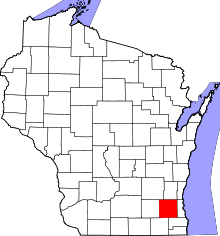 | |
| Villages | ||
| Towns | ||
| CDP | ||
| Unincorporated communities | ||
| Ghost towns | ||
| Footnotes | ‡This populated place also has portions in an adjacent county or counties | |
| Central city |  | |
|---|---|---|
| Largest municipalities (over 25,000 in 2010) | ||
| Municipalities (over 10,000 in 2010) | ||
| Smaller municipalities (under 10,000 in 2010) | ||
| Counties | ||