Belgaum district
| Belgaum district ಬೆಳಗಾವಿ ಜಿಲ್ಲೆ | |
|---|---|
| district | |
| Belagavi district | |
|
Gokak Falls in Belgaum district | |
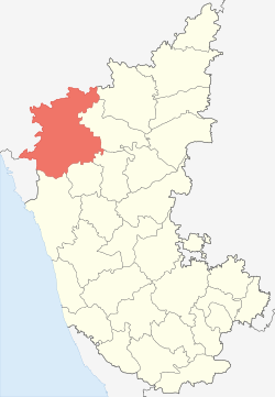 Location in Karnataka, India | |
| Coordinates: 15°51′N 74°33′E / 15.85°N 74.55°ECoordinates: 15°51′N 74°33′E / 15.85°N 74.55°E | |
| Country |
|
| Region | North Karnataka |
| Division | Belgaum division |
| Headquarters | Belgaum |
| Area[1] | |
| • Total | 13,415 km2 (5,180 sq mi) |
| Population (2011)[1] | |
| • Total | 4,778,439 |
| • Density | 360/km2 (920/sq mi) |
| Languages | |
| • Official | Kannada |
| Time zone | IST (UTC+5:30) |
| ISO 3166 code | IN-KA |
| Vehicle registration | KA-22,KA-23,KA-24,KA-49 |
| Sex ratio | 1.04 ♂/♀ |
| Literacy | 64.2% |
| Precipitation | 823 millimetres (32.4 in) |
| Website |
belgaum |

Belgaum is a district in the state of Karnataka, India. The city of Belgaum is the district headquarters in North Karnataka. It is also called as the second capital for the state of Karnataka, as it houses the Suvarna Vidhana soudha. According to the 2011 Census of India, it has a population of 4,778,439 of which 24.03% live in urban areas,[2] making it the second most populous district in Karnataka (out of 30), after Bangalore.[3] The district has an area of 13,415 square kilometers, and is bounded on the west and north by Maharashtra state, on the northeast by Bijapur District, on the east by Bagalkote District, on the southeast by Gadaga District, on the south by Dharawad District and Uttara Kannada districts, and on the southwest by the state of Goa.
History


Belgaum is the Divisional Headquarters of North Karnataka The ancient name of the town of Belgaum was Venugrama, meaning Bamboo Village. It is also called as Malnad Pradesh. The most ancient place in the district is Halsi; and this, according to inscriptions on copper plates discovered in its neighborhood, was once the capital of a dynasty of nine Kadamba kings. It appears that from the middle of the 6th century to about 760 the area was held by the Chalukyas, who were succeeded by the Rashtrakutas. After the break-up of the Rashtrakuta power a portion of it survived in the Rattas (875–1250), who from 1210 onward made Venugrama their capital. Inscriptions give evidence of a long struggle between the Rattas and the Kadambas of Goa, who succeeded in the latter years of the 12th century in acquiring and holding part of the district. By 1208, however, the Kadambas had been overthrown by the Rattas, who in their turn succumbed to the Yadavas of Devagiri in 1250. After the overthrow of the Yadavas by the Delhi Sultanate (1320), Belgaum was for a short time under the rule of the latter; but only a few years later the part south of the Ghataprabha River was subject to the Hindu rajas of Vijayanagara. In 1347 the northern part was conquered by the Bahmani Sultanate, which in 1473 took the town of Belgaum and conquered the southern part also. When Aurangzeb overthrew the Bijapura sultans in 1686, Belgaum passed to the Mughals. In 1776 the country was overrun by Hyder Ali of Mysore, but was taken by the Madhavrao Peshwa with British assistance. In 1818 it was handed over to the British East India Company, and was made part of the district of Dharwar. In 1836 this was divided into two parts, the northern district becoming Belgaum.[4]
Yadur is situated beside Krishna river, there is famous veerbhadra temple. Many devotees visit this place from Karnataka and Maharashtra. Hooli is one of the oldest villages in Belgaum district. There are many Chalukya temples in the village and the 'Panchaligeswara temple is very famous.
Kittur in Belgaum district is a place of historical importance. Rani Chennamma of Kittur (1778–1829) is known for her resistance to British rule.
The British had a sizable infantry post here, having realised the military importance of its geographic location. It is one of the reasons for Belgaum's sobriquet The Cradle of Infantry. Development of a rail network for the movement of resources and later troops was one of the means employed by both the British East India Company and the British to exert control over India. Belgaum's railway station, the Mahatma Gandhi Railway Station was established by the British. A signboard declaring the sobriquet can be seen hung on Platform 1 at the station.
Border dispute
Belgaum district was incorporated into the newly formed Mysore state (now Karnataka) with the passage of the States Reorganisation Act (1956), which reorganized India's states along linguistic lines since the majority of the people in the district spoke Kannada. Because of that linguistic disparity, the case is now in the Supreme Court of India.
Divisions
Administrative divisions
Administration of Belgaum District has been divided into 14 taluks. Athani taluk is the largest with an area of 1,997.70 km² and Raybag taluk is the smallest with an area of 958.8 km². The district comprises three revenue sub-divisions and six police sub-divisions. Apart from the Belgaum City Corporation, there are 17 municipalities, 20 towns, 485 gram panchayats, 1,138 habitated villages and 26 non-habitated villages. Belgaum is also the headquarters of the Belgaum Revenue Division.
Cities and towns

There are 34 cities and towns in Belagavi district. 5 cities and 29 towns; they are :
- Belgaum
- Gokak
- Athani
- Nippani
- Bailhongal
- Chikkodi
- Sankeshwar
- Ramdurg
- Kudchi
- Raybag
- Sadalga
- Mudalagi
- Ugar
- Mugalkhod
- Harugeri
- Hukkeri
- Khanapur
- Konnur
- Ainapur
- Examba
- Chinchali
- Boragoan
- Shedbal
- [[M K Hubli] M K for Mugut Khan]
- Manoli
- Kittur
- Kagwad
- Kerur
- Hidkal
- Kalloli
- Mole
- Kanakwadi
- Mallapur
- Nagnur
- savadatti
- munavalli
- hoolikatti
Demographics
According to the 2011 census Belgaum district has a population of 4,778,439,[3] roughly equal to the nation of Singapore[5] or the US state of Alabama.[6] This gives it a ranking of 25th in India (out of a total of 640).[3] The district has a population density of 356 inhabitants per square kilometre (920/sq mi) .[3] Its population growth rate over the decade 2001–2011 was 13.38%.[3] Belgaum has a sex ratio of 969 females for every 1000 males,[3] and a literacy rate of 73.94%.[3]
Kannada is the main language and is spoken by a majority of the population of the district (by 73%). Marathi is also spoken in the cities of Belgaum, Khanapur, Nipani, Ugar and also in some of the villages in southern part of Belgaum and Khanapur taluka. There is also sizable population of Dakhini (a southern dialect of Urdu) and Konkani speakers in the district.
Culture
Tourist sites


Tourism attractions of Belgaum District[7]
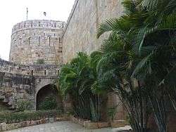
- Belgaum is famous for Belgaum Fort, Kamal basadi Jain temple, Safi Maszid and many historical monuments. Belgaum Fort which is in the heart of the city. The Kote lake is also a beautiful lake to visit. Inside the fort we can find an ancient Kamala Basadi and Chikka Basadi Jain temples. Just few metres walk to this temple you can find Ramkrishna Ashrama where you can relax. There is an ancient Mosque also in the fort. Belgaum Cantonment with both Portuguese and British style buildings, churches and schools.
- Hooli is famous for Panchalingeshwara temple 13 km from Savadatti, one of the oldest village in the district, it is famous for Panchaligeswara temple. Other ruined Chalukya temples await for conservation and restoration.
- Mugalakhod is located in Rayabag taluk and it is famous for Shri Yallalingeswar Temple [Mugalakhod Math]
- Gokak Falls
- Shedbal, Shedbal is a village in the southern state of Karnataka, India.[1][2] It is located in the Athni taluk of Belgaum district in Karnataka. There is a famous Jain Ashram. The Shanthinatha Jain temple of Shedbal was built in the year 1292 A.D. It is the birthplace of the well known Jain ascetic Elacharya Paramapujya Muni Sri 108 Vidyananda Maharaj. Under the guidance of Paramapujya Muni Sri Shanthisagar Maharaj Shanthisagar Chatra Ashram was built. The Chaturvamshathi tirthankara mandir with the 24 tirthankaras was built in 1952.
- Jamboti, 20 km south-west of Belgaum, is a popular tourist spot with its evergreen hilltop forests.
- Varapoha Falls, where the Mandovi River plunges 60 meters, is a beautiful waterfall in Belgaum district.
- Saundatti is famous for Savadatti Fort and historical temples.
- Kittur is famous for Kittur fort, museum and other monuments
- Shirasangi is famous for Desai wade, Kalika Temple and other historical monuments.
- Turmari is about 7 km from Sangolli, is famous for B C Patil house (Goudaramane) more than 300 year old and two floor mansion, where the Girish Karnad movie Ondanondu Kaladalli was shot.
- Kamala Narayana Temple, Degaon (Degamve / Devgram) is famous for Kamala Narayana Temple is about 5 km from Kittur.
- Kasamalgi Parshwanatha is about 10 km from Kittur and 5 km from Kamala Narayana Temple, Degaon (Degamve / Devgram).
- Halasi is famous Kadamba temple of Bhuvaraha Narasimha.
- Yallammagudda is famous for Renuka Yallamma temple, people from Maharashtra, Andhra and south India visit.
- Navilateertha
- Stavanidhi Ghat Jain Temple Stavanidhi or Tavandi Ghat is situated near Nipani city there is an ancient famous Jain math and Temple.
- Parasgad Fort
- M.K.Hubli is famous for Ashwatha Narasimha Temple and Gangamata Memorial in Malaprabha River, and a very famous Darga where M.K.Hubli is specifically named of "Hazarat Mughut Khan Sahab".
- Sangolli the village is named on freedom fighter of Kittur Rani Chennamma Right Hand Sangoli Rayanna
- Nandagad is place where freedom fighter Sangoli Rayanna was hanged by British Govt.
- Panchalingeshwara temple at Munavalli
- Chandur,Yadur situated beside Krishna river
- Boragaon situated beside Dudhganga river. A Jain Temple (Nishidhi) situated in this village.
- Konnur situated beside Ghatprabha river. A Hindu Temple (Kadasiddeshwar) situated in this city.
Notable personalities
- Pandit S. Ballesh - Shehnai artist
- Kittur Chennamma
- Kumar Gandharva
- Kaka Kalelkar (1885–1981) - social reformer, scholar, historian, educationist, and journalist; born in Belgundi
- Chandrashekhara Kambara
- Atul Kulkarni
- Belawadi Mallamma
- Sangolli Rayanna
- Dr Sudarshan Gadad Young - animal geneticist
Education
Visveswaraiah Technological University is located in Belgaum. All technical and engineering colleges in the Karnataka State come under this University. Belgaum is also known for the Airmen Training School, an Indian Air Force training centre located at Sambra. The Maratha Light Infantry has its regimental headquarters in Belgaum. The Commando School and School of jungle warfare and the Indian Army is also situated in Belgaum. The Karnataka Lingayat (K.L.E.) Education Society is in Belgaum. The K.L.E.S. Hospital of Belgaum is the second-largest hospital in Asia . The Medical Council of India has one of its regional research centre here, and the Indian Institute of Hydrology and Vaccine Institute are also situated here. Military School Belgaum is one of the five military schools in India. The school was set up in 1945 by King George VI for the wards of VCOs (present day JCOs) and NCOs of the Indian Army.
Belgaum has an educational training center called DIET located at Manur village at a distance of about 10 km from the city. This Center is headed by Principal & DDPI Development Shri. D. M. Danoji.
DEIT has seven wings and 37 dedicated staff.
References
|
External links
| Wikimedia Commons has media related to Belgaum district. |
- Official Website of Belgaum district
- List of places in Belgaum

District HQ: Belgaum | |
|
| Overviews | |
|---|---|
| History |
|
| Geography |
|
| Culture | |
| Literature | |
| Noted poets |
|
| People and Society | |
| Tourism |
|
| Awards | |