Gadag district
| Gadag district ಗದಗ ಜಿಲ್ಲೆ | |
|---|---|
| District | |
|
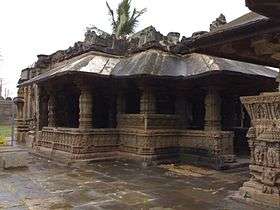
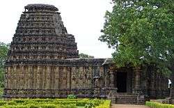
Jain temple at Lakkundi in Gadag District | |
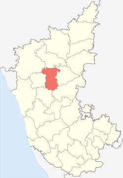 Location in Karnataka, India | |
| Coordinates: 15°24′N 75°45′E / 15.4°N 75.75°ECoordinates: 15°24′N 75°45′E / 15.4°N 75.75°E | |
| Country |
|
| Division | Belgaum division |
| Headquarters | Gadag |
| Area† | |
| • Total | 4,656 km2 (1,798 sq mi) |
| Population (2001)† | |
| • Total | 971,835 |
| • Density | 209/km2 (540/sq mi) |
| Languages | |
| • Official | Kannada |
| Time zone | IST (UTC+5:30) |
| Telephone code | 08372XXXXXX |
| Vehicle registration | KA-26 |
| Sex ratio | .969 ♂/♀ |
| Literacy | 66.1% |
| Climate | Tropical wet and dry (Köppen) |
| Precipitation | 631 millimetres (24.8 in) |
| Website |
gadag |
The Gadag District is a district in the state of Karnataka, India. The district formed in 1997, when it was split from the Dharwad District. As of 2011, the Gadag District had a population of 971,952 (of which 35.21 percent was urban as of 2001). The overall population increased by 13.14 percent from 1991 to 2001. The Gadag District borders the Bagalkot District on the north, the Koppal District on the east, the Bellary District on the southeast, the Haveri District on the southwest, the Dharwad District on the west and the Belgaum District on the northwest. The district features monuments (primarily Jain and Hindu temples) from the Western Chalukya Empire. Gadag District has seven tehsils: Gadag-Betgeri, Ron, Shirhatti, Nargund, Lakshmeshwar, Gajendragad and Mundargi.
Historical sites
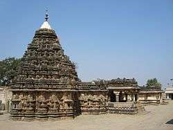

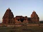

The town has 11th- and 12th-century monuments; the temple of Veera Narayana and the Trikuteshwara complex are sites of religious and historic importance. One of the two main Jain temples is dedicated to Mahavira.
- Trikuteshwara temple complex:
The Trikuteshwara temple was built by the early Chalukyas between the sixth and the eighth centuries, exemplifying Chalukya architecture. The temple is dedicated to Saraswati.
- Veeranarayana Temple:
The temple, believed to have been built during the 11th century, attracts many devotees a year.
- Jumma Masjid:
The Muslim Jumma Masjid has a capacity of 600. During the 17th and 18th centuries, Gadag was ruled by Muslim kings and the Maratha before being incorporated by the East India Company.
Lakshmeshwara is in Shirahatti, and is known for its Hindu and Jain temples and mosques. The Someshwara temple complex has a number of temples to Shiva in its fort-like compound.
Chalukya monuments include the Jodi Gopura and Mallikarjuna temples and large Ganesha and Nandi statues.
About 12 kilometres (7.5 mi) from Gadag, Lakkundi was the residence of the Chalukyan kings. It is known for its 101 stepwells (known as kalyani or pushkarni) and its Hindu and Jain temples. A sculpture gallery is maintained by the Archaeological Survey of India.
Dambal is known for its 12th-century Chalukya Doddabasappa Temple.
Known for its hill fort and Kalakaleshwara temple
- Nagavi
Famous Yellamma devi temple loacated ,With hill view choultry is under construction .Just 8 km from Gadag Center.Political rich village .
Harti has a number of Hindu temples. The Shri Basaveshwara Temple has an annual festival featuring a procession. Other temples, such as the Parvati Parameshwara temple (Uma Maheshwara Temple), have stone carvings from the Chalukya period.
About 22 kilometres (14 mi) from Gadag, the agricultural village is also known for its Someswar and Durgadevi temples. Chamarasa, author of the Prabhulingaleele, was born nearby.
Home to the largest Jain temple built by the Rastrakuta dynasty[1]
About 12 kilometres (7.5 mi) from Gadag, the village is known for old temples.
Belavanaki about 33 km from Gadag,the village is known for newly carved statue of Veerabhadra which is considered to be best kind of sculpture in recent time and, earlier village was part of Belavalanaadu-300 or Belvola-300 therefore from that its name was derived.It is also Birthplace of well known social activist S. R. Hiremath.
Ron's historic monuments include Anantsayee Gudi, Isvara Gudi, Isvara Temple, Kala Gudi, Lokanatha Temple, Mallikarjuna Gudi, Parsvanath Jain temple and the Somlingesvara temple.
About 16 kilometres (9.9 mi) from Gadag, the agricultural village is known for the Shri Ugra Narsimha, Dattatreya, Virupakhshalinga and Rama temples. Statues of Rama, Lakshmana and Sita were installed by Brahma Chaitanya. Writer and critic Kirtinath Kurtakoti hailed from the area.
Known for its role in the 1857 revolt and its 17th-century fort and1980s Peasant movement durong Gundurao as a chief minister of Karnataka. and also birthplace of senior leader of Jana Sangh Jagannathrao Joshi.
- Doni Tanda

About 24 kilometres (15 mi) from Gadag, and known for wind-power generation
- Beladhadi
About 10 kilometres (6.2 mi) from Gadag, and known for its Shri Rama Temple and statues of Sri Rama, Lakshmana and Sita
- Antur Bentur
About 23 kilometres (14 mi) from Gadag, the agricultural village is known for the Shri Jagadguru Budimahaswamigala Sanstan math Antur Bentur – Hosalli. The matha is cared for by both Muslims and Hindus.
Demographics
According to the 2011 census the district has a population of 1,065,235,[2] roughly equal to that of Cyprus[3] or the US state of Rhode Island.[4] This ranks it 426th in India (out of a total of 640).[2] The district has a population density of 229 inhabitants per square kilometre (590/sq mi).[2] Its population growth rate from 2001 to 2011 was 9.61 percent.[2] The district has a sex ratio of 978 females for every 1000 males[2] and a literacy rate of 75.18 percent.[2]
Magadi Bird Sanctuary
The Magadi Bird Sanctuary,[5] created at the Magadi reservoir, is 26 kilometres (16 mi) from Gadag on the Gadag-Bangalore Road, 8 kilometres (5.0 mi) from Shirhatti and 11 kilometres (6.8 mi) from Lakshmeshwar. It is known for migratory species such as the bar-headed goose, which feed on fish and agricultural crops.
Notable Persons from Gadag District
- Poets Kumara Vyasa (born in Koliwada) and Chamarasa are known for their translation of the Mahabharata into Kannada (Karnata Bharatha Kathamanjari) and Prabhulingaleele, respectively.
- Ganayogi Panchakshari Gavayi
- Bhimsen Joshi Hindustani singer
- Puttaraj Gawai
- Rajguru Guruswami Kalikeri A noted Writer/Musician,Winner Karnataka State Rajyotsva award,Santha Shishunala Sharif Award, Karnataka Kalashree, etc.[6][7][8]
- Sunil Joshi (cricketer)
- Jagannathrao Joshi
- Chennaveera Kanavi
- S. R. Hiremath
- Aluru Venkata Rayaru
Independence movement
Huilgol Narayana Rao, Shankar Rao Kampli, Marthandarao Nargundkar and their followers contributed to India's independence struggle.
Cooperative movement
The first cooperative in India was founded over 100 years ago in Kanaginahal,[9] and K. H. Patil aided in its modernisation.
Wind-power generation
The district generates wind power[10] at Kappatagudda, Kurtkoti and Gajendragad.
See also
- North Karnataka
- Tourism in North Karnataka
- Lakkundi
- Sudi
- Lakshmeshwara
- Gajendragad
- Dambal Doddabasappa Temple
- Naregal, Gadag
- Mahadeva Temple (Itagi)
- Itagi Bhimambika
- Belavanaki(ಬೆಳವಣಿಕಿ)
References
- ↑ "Jain monuments in North Karnataka". Dr. A. V. Narasimha Murthy. Archived from the original on 23 August 2009. Retrieved 25 November 2008.
- 1 2 3 4 5 6 "District Census 2011". Census2011.co.in. 2011. Retrieved 30 September 2011.
- ↑ US Directorate of Intelligence. "Country Comparison:Population". Retrieved 1 October 2011.
Cyprus 1,120,489 July 2011 est.
- ↑ "2010 Resident Population Data". U. S. Census Bureau. Retrieved 30 September 2011.
Rhode Island 1,052,567
- ↑ "Magadi tank, Biodiversity hotspots of Karnataka". Dr. A. V. Narasimha Murthy. Retrieved 25 November 2008.
- ↑
- ↑
- ↑
- ↑ "Co-op. movement took its birth here". The Hindu. Chennai, India. 13 April 2009. Retrieved 13 April 2009.
- ↑ "About Gadag". Retrieved 13 April 2009.
External links
| Wikimedia Commons has media related to Gadag district. |
 Gadag (district) travel guide from Wikivoyage
 |
Belgaum district | Bagalkot district | | |
| Dharwad district | |
Koppal district | ||
| ||||
| | ||||
| Haveri district | Bellary district |