Hassan district
.jpg)
| Hassan district ಹಾಸನ ಜಿಲ್ಲೆ Male Nadu | |
|---|---|
| district | |
|
Lakshmi Narasimha Temple 1246 Trikuta architecture, Nuggihalli | |
| Coordinates: 13°N 76°E / 13°N 76°ECoordinates: 13°N 76°E / 13°N 76°E | |
| Country |
|
| State |
|
| Headquarters | Hassan |
| Talukas | Hassan, Holenarsipur, Arkalgud, Channarayanapatana, Sakleshpur, Belur, Alur, Arasikere |
| Languages | |
| • Official | Kannada |
| Time zone | IST (UTC+5:30) |
| PIN | 573201 |
| Telephone code | 08172 |
| Vehicle registration | KA-13, KA-46 |
| Website |
www |
Hassan is a district in Karnataka state, India. The district headquarters are Hassan.
History
Hassan district was the seat of the Hoysala Empire which at its peak ruled large parts of south India from Belur as its early capital and Halebidu as its later capital during the period 1000 - 1334 CE.
The place is called Hassan after the Goddess "Haasanamba", the goddess and presiding deity of the town. The history of Hassan district is essentially the history of two of the well known dynasties that have ruled Karnataka, the Western Ganga Dynasty of Talkad (350 - 999 CE) and the Hoysala Empire (1000 - 1334 CE). In the 15th and 16th centuries, the Vijayanagar kings patronised Chennakesava of Belur as their family deity. It was also ruled by Adilshahis of Bijapur and Mughal Empire after decline of the Vijayanagar. In the 17th and 18th centuries, Hassan became a land of contention between the Keladi Nayakas of Shimoga and the Mysore Kingdom. It finally merged as an independent Mysore kingdom.
Ancient
Around 300 BCE Hassan was part of the Mauryan empire. Sage Bhadrabahu arrived from north India in the 3rd century BCE along with many ascetics marking the arrival of Jainism into Karnataka.
Medieval
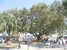
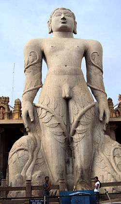
Later Hassan came under the rule of the Ganga Dynasty of Talkad. The Gangas initially ruled as a sovereign power from 350 - 550 CE and later continued to rule this area as feudatories of Chalukyas and Rashtrakutas. In the late 10th century, many Jaina monuments were built at Shravanabelagola. Some of them, including the fifty seven feet tall monolithic statue of Gomateshwara, was commissioned by Ganga general Chamundaraya.
During the rule of the Gangas, Shravanabelagola was an important religious centre. The name of the town is derived from Shravana or Shramana, meaning a Jain ascetic, and Belagola or Biliya Kola in Kannada meaning white pond.
Around 1000 CE, with their complete defeat at the hands of the Cholas, the Ganga lineage vanished forever from Gangavadi (southern districts of Karnataka). From that time onwards, till 1334 CE, Hoysalas ruled this region and after their decline, the Vijayanagar empire took control. After the decline of the Vijayanagar empire, the area came under the rule of the Mysore Kingdom.
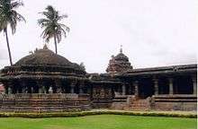
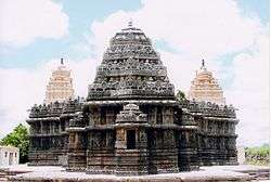
It was under the rule of the Hoysalas, a clan of hill people whose origins are traced to Angadi in Chikmagalur District who built a powerful empire from the Malnad region of Karnataka that Hassan reached its zenith of fame, much of which is seen today in the fifty or more Hoysala temples scattered around the country side in the district. Inscriptions in many of these temples speak volumes of the glory of a bygone era, the administration of the Hoysalas, their land reforms, taxation, culture and so on.
The Hoysalas, who claim to be of the Kuruba/Yadava race stepped into the shoes of their predecessors, the Gangas after being feudatories of the Chalukyas of Kalyani from about 1000 - 1150 CE. After the decline of the Kalyani Chalukyas power and constant efforts by Hoysala Vishnuvardhana to break free of subordination to the Chalukyas, the Hoysalas emerged as an independent power in the middle of the 12th century. Vishnuvardhana who went by the name Bittideva was a Jaina but later changed his name having accepted Vaishnavism, a sect of Hinduism.
During the rule of his grandson, Veera Ballala II 1173 – 1220 CE who earned the title Cholarajyapratishtacharya or preserver of the Chola Empire, the Hoysalas were able to become a true force to reckon with in South India.
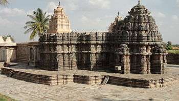
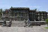
Hoysala architecture
_in_Hoysaleshvara_Temple_at_Halebidu.jpg)
The Hoysalas claim to immortality arises from their contribution to Kannada culture, Kannada literature and their own unique style of vesara architecture. Historians such as Henry Cousens and James Furgusson observed that the Hoysala style of architecture is essentially an extension and culmination of the vesara style initiated by the Badami Chalukyas and further enhanced by the Kalyani Chalukyas. In fact, the carved doorways, lathe turned pillars and pierced window screens used frequently by the Hoysalas is also commonly seen in earlier Kalyani Chalukya temples of north and central Karnataka. The Star shaped platform on which many Hoysala temples were constructed, the Jagati, the Zig- Zag character of the walls and the density of sculpture on gray soap stone (chloritic schist) is however a unique features of Hoysala architecture.
Modern
During the 14th century, invasions by the Sultanate of Delhi weakened the Hoysala state, and the district became part of the Vijayanagara Empire.[1] In the 15th and 16th centuries, the Vijayanagar kings patronised Chennakesava of Belur as their family deity. It was also ruled by Adilshahis of Bijapur and Mughal Empire after decline of the Vijayanagar. In the 17th and 18th centuries, Hassan became a land of contention between the Keladi Nayakas of Shimoga and the Mysore Kingdom. In 1648 the Mysore rulers built Channarayapatna fort by treaty with the sultans of Bijapur. A peace treaty was concluded between the Mysore and Keladi rulers in 1694.[1] The district remained part of the Mysore Kingdom at the conclusion of the Fourth Anglo-Mysore War in 1799.
Hassan District and its current boundaries date to the 1860s, when the Mysore Kingdom was organized into 8 districts, and the districts further divided into taluks.[2] The district had a population of 518,987 in the 1871 census. A famine from 1876 to 1878 reduced the population to 428,344 by 1881. The population was 511,975 in 1891, and 568,919 in 1901. The 1901 census recorded 541,531 Hindus, 16,668 Muslims, 5035 Animists, 3795 Christians, 1874 Jains, and 16 others. The district had 14 towns, and 2546 villages.[3]
Reserve forests were established in the 19th century, and covered an area of 185 square miles in the district. The forests, with their area in square miles, were: Kempuhole Ghat (16), Kaganeri Ghati (2), Kabbinale Ghat (23), Bisale Ghat (23), Vijayapur (5), Hirikalgudda (92), Doddabetta (3), Burdalbore (3), Hagare (3), Byaba (2), Sige-gudda (8), Baisur (1), Mallappan-betta (1), and Vantigudda (1). The state established five sandalwood forests, totaling three square miles: Kemmanbore (232 acres), Gubbi (428 acres), Gadagere (554 acres), Gubbi (1000 acres), and Nakalgud (185 acres).[4]
After India's independence in 1947, Mysore Kingdom became Mysore State, which was renamed Karnataka state in 1973.
List of Temples
- Chennakesava Temple, Belur
- Hoysaleswara Temple, Halebidu
- Bahubali Temple, Shravanabelagola
- Hasanamba Temple, Hassan
- Jenukallu Siddeshwara Temple, Arsikere
Geography
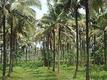
Lying between 12° 13´ and 13° 33´ North latitudes and 75° 33´ and 76°38´ East longitude, Hassan district has a total area of 6826.15 km². The geography is mixed with the malnad or mountainous region to the west and south west called Bisle Ghat and the maidan or plains regions in the north, south and east. There are some areas of degraded forest ranges in central portion of the district.
The district is surrounded by Chikmagalur District to the north west, Chitradurga District to the north, Tumkur District to the east, Mandya District to the south east, Mysore to the south, Kodagu District to the south west and Dakshina Kannada district to the west.
Hassan and Belur stand around 3,084 feet (940 m) and 3,150 feet (960 m) above sea level, respectively.
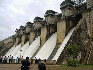
Most of the district lies in the watershed of the Hemavathi River, a tributary of the Kaveri River. The general level of Hassan district slopes with the course of the Hemavati, from the peaks of the Western Ghats downwards to the southeast. The chief tributary of the Hemavathi is the Yagachi River, which flows southward from Belur taluk to join the Hemavathi near Gorur. In 1981 the Hemavathi Dam was completed near Gorur, downstream from the confluence with the Yagachi, creating a reservoir of 8000 hectares.[5] The Hemavathi passes through Holenarsipur taluk in a southerly direction and joins with the Kaveri near Hampapura in Mysore district, close to the border of Hassan district. The Kaveri flows through the southernmost part of the District.
Western portions of the district are drained by the headwaters of the Netravati River, which flows northwestward to empty into the Arabian Sea. Portions of Asikere taluk in the northeast are drained by the Hogari River, a tributary of the Tungabhadra River. The basins of the Kaveri and Tungabhadra are separated by a range of low granitic hills extending through Belur, Hassan, and Arsikere taluks.
The Bisle Ghat, or Bisale Ghat, is a portion of the Western Ghats range in the western part of the district. Main peaks include Jenkalbetta (4,558 feet (1,389 m)), the highest peak in the district, Murkangudda (4,265 feet (1,300 m)), and Devarbetta (4,206 feet (1,282 m)). Pushpagiri (1,712 meters), lies immediately southwest in Kodagu and Dakshina Kannada districts. Bisle, Kagneri, Kanchankumari reserve forests cover portions the Bisle Ghat, and adjoin Pushpagiri Wildlife Sanctuary in Kodagu.
Administrative divisions
Hassan District is administratively divided into eight talukas (Panchayat blocks): Alur, Arkalgud, Arsikere, Belur, Channarayapatna, Hassan, Holenarasipura (H.N. Pura) and Sakleshpur,[6] and 258 panchayat villages.[7]
Demographics
According to the 2011 census Hassan district has a population of 1,776,221,[8] roughly equal to the nation of The Gambia[9] or the US state of Nebraska.[10] This gives it a ranking of 270th in India (out of a total of 640).[8] The district has a population density of 261 inhabitants per square kilometre (680/sq mi) .[8] Its population growth rate over the decade 2001-2011 was 3.17%.[8] Hassan has a sex ratio of 1005 females for every 1000 males,[8] and a literacy rate of 75.89%.[8][11]
Transport
Air
Hassan Airport is expected to be operational by 2018 and is expected cater to a passenger capacity of 3 million and cargo capacity of 100,000 ton yearly.[12] The airport will be an aircraft maintenance and modification (AMM) hub.[13]
Road
The Karnataka State Road Transport Corporation operates connecting Hassan with other parts of Karnataka as well as other states. Hassan is connected by road via national highway No. 75 to the rest of the country.
Rail
Hassan comes under the South Western Railway zone of the Indian Railways. Hassan City Railway station connects it to the rest of the country through the Indian Railways.
Education
People from the Hassan district
- H.D. Deve Gowda, former prime minister of India
- Gorur Ramaswamy Iyengar, Kannada literature
- S.L. Bhairappa, Kannada literature
- Vishnuvardhana, Hoysala king
- Veera Ballala II, Hoysala king
- Veera Ballala III, Hoysala king
- Doddanna, film actor
- Narayana Gowda, Karnataka Rakshana Vedike state president.
- Javagal Srinath, former Indian cricketer.
- David Johnson, former Ranji Player
- Sampath, film actor
- Shruthi, film actress
- G.R. Gopinath, founder of Air Deccan
- Dheerendra Gopal, film actor
- A. S. Kiran Kumar, ISRO Chairman
- K. S. Ashwath, film Actor
- H.D.Kumaraswamy, former chief minister of Karnataka
- H. D. Revanna, former minister of Karnataka
- Anoop Seelin, music Director and playback singer
Image gallery
-
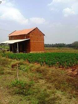
Kayanahalli, Saligrama
-
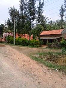
Keralapura, Saligrama
-
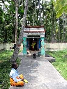
Saligrama second temple
Notes
- 1 2 Meyer, Sir William Stevenson. The Imperial Gazetteer of India. Oxford, Clarendon Press, 1908-1931. v. 13, p. 64.
- ↑ Meyer, Sir William Stevenson, et al. The Imperial Gazetteer of India. Oxford, Clarendon Press, 1908-1931. v. 18, p. 228.
- ↑ Meyer, Sir William Stevenson. The Imperial Gazetteer of India. Oxford, Clarendon Press, 1908-1931. v. 13, pp 64-65.
- ↑ Rice, B. Lewis. Mysore: A Gazetter Compiled by the Government. Revised Edition 1897; reprinted 2001 by Asian Educational Services, New Delhi. p. 327
- ↑ Sugunan, V. V. (1995). Reservoir Fisheries of India Issue 345 of FAO fisheries technical paper, Food and Agriculture Organization. ISSN 0429-9345. p. 155
- ↑ "Official Website of Hassan District". Hassan District Administration.
- ↑ "Reports of National Panchayat Directory: Block Panchayats of Hassan, Karnataka". Ministry of Panchayati Raj, Government of India. 2011. Archived from the original on 13 November 2011.
- 1 2 3 4 5 6 "District Census 2011: Hassan". Census2011.co.in. 2011. Retrieved 2011-09-30.
- ↑ US Directorate of Intelligence. "Country Comparison:Population". Retrieved 2011-10-01.
Gambia, The 1,797,860 July 2011 est.
- ↑ "2010 Resident Population Data". U. S. Census Bureau. Retrieved 2011-09-30.
Nebraska 1,826,341
- ↑ "City census 2011". Census-2011.
- ↑ "Profile".
- ↑ "Press release".
References
- Kamath, Suryanath U. (2001). A Concise History of Karnataka from pre-historic times to the present, Jupiter books, MCC, Bangalore (reprinted 2002), OCLC 7796041
External links
| Wikimedia Commons has media related to Hassan district. |
- "Activities of Hassan District NRDMS Centre" (PDF). 2012.
- Hassan History
- History of Shravanabelagola
- History of Karnataka, Arthikaje
- Census India
- Protected Monuments of Hassan
- In and Around Shravanabelagola
- Bringing glory back to temples
 |
Chikmagalur district | Tumkur district (Southern) | | |
| Dakshina Kannada district | |
|||
| ||||
| | ||||
| Kodagu district | Mysore district | Mandya district |