Bidar district
| Bidar district ಬೀದರ್ ಜಿಲ್ಲೆ | |
|---|---|
| District | |
 | |
| Nickname(s): Crown of Karnataka | |
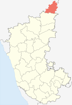 Location in Karnataka,India | |
| Country |
|
| State | Karnataka |
| Division | Kalaburagi division |
| Elected Representative(s) | MP |
| Constituency | One: Bidar (Lok Sabha constituency) |
| Government | |
| • Type | Zilla Panchayat |
| • Body | Council |
| Area[1] | |
| • District | 5,448 km2 (2,103 sq mi) |
| • Forest cover | 436 km2 (168 sq mi) |
| Elevation[2] | 615 m (2,018 ft) |
| Population (2011)[1] | |
| • District | 1,703,300 |
| • Estimate (2021)[3] | 1,927,828 |
| • Rank | 287 (out of 640) |
| • Density | 310/km2 (810/sq mi) |
| • Urban[1] | 425,952 |
| • Rural[1] | 1,277,348 |
| • Male Population | 870,665 |
| • Male Population density | 159/km2 (410/sq mi) |
| • Female Population | 832,635 |
| • Female Population density | 153/km2 (400/sq mi) |
| Sex ratio[1] | |
| • per 1000 males | 956 females |
| • in the age group 0-6 | 942 |
| Literacy rate[1] | |
| • Average | 70.51% |
| • Male | 79.09% |
| • Female | 61.55% |
| Time zone | IST (UTC+5:30) |
| Vehicle registration | KA-38, KA-39 and KA-56 |
| Precipitation | 847 millimetres (33.3 in) |
| No. of villages | 699 |
| Website |
bidar |

The Bidar district is the northernmost part of the Karnataka state in India. Geographically, it resembles the Crown of the State occupying its northeastern tip. It is bounded by Nizamabad and Medak districts of Telangana state on the eastern side, Latur and Osmanabad districts of Maharashtra state on the western side, Nanded district of Maharashtra state on the northern side and Gulbarga district on southern side.
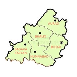
The Bidar district is constituted by five talukas viz. Aurad, Basavakalyan, Bhalki, Bidar and Humnabad with Bidar being the headquarters of the district.
It is connected with NH9 and NH218.
History
The traditional tales refer this as Viduranagara of Mahabharata times and also as the place where Nala and Damayanthi were meeting.[4] Historically, the district had a glorious past. It was ruled by the Mauryas, Satavahanas, Rashtrakutas, Chalukyas, Kalachuris, Kakatiyas, Khiljis, Bahamanis, Baridshahis, Mughals and the Hyderabad Nizam. The treasure of culture, fine arts and architecture nurtured by successive rulers has contributed to its richness. As such, there are more Hindus and Muslims in Bidar district with their rich culture. Similarly, social and religious reformers such as Basaveshwara and Guru Nanak also played significant role in social reformation based on equality.[5] The great revolution by Shivasharanas in the 12th century, encompassing social, literacy and religious fields emerged on this land.
Bidar district is popular for different religions, castes and cultures due to its historical developments through the ages.[5]
Early and medieval history
The first Rashtrakuta capital was Mayurkhandi (Morkhandi) in the present day Bidar district. The regal capital was later moved to Manyakheta (Malkhed) in the present day Kalaburagi district by Amoghavarsha I.[6]
Kalyani (today called Basavakalyan after Basaveshwara) in Bidar district was the capital of Western Chalukyas, who were also called Kalyani Chalukyas after their capital. The Kalachuris continued with Kalyani as their capital.
Later, Bidar was ruled in succession by the vassals to Sevuna Yadavas of Devagiri, Kakatiyas of Warangal, Allauddin Khilji and Muhammad bin Tughluq.
The generals of Muhammad Bin Tughlaq who were nominated as viceroys of the newly conquered Deccan region broke up and formed the Bahmani Sultanate under Allauddin Hasan Gangu Bahman Shah.
The Bahmani capital was shifted from Kalburgi or Kalubaruge (pronounced as Gulbarga and subsequently renamed Ahsanabad by the Muslim newcomers) to Bidar (renamed Muhammadabad by the Bahmanis) in 1425. Bidar remained the capital until the Sultanate's breakup after 1518. It then became the center of the Barid Shahis, one of the five independent sultanates known as the Deccan sultanates. These were the successor states to the Bahmani kingdom.
The Bidar Sultanate was absorbed by the Bijapur Sultanate to the west in 1619, which was in turn included into their Deccan province by the Mughal Emperor Aurangzeb during his viceroyship of Deccan in 1656. After the death of Aurangazeb, Asaf Jah I, the Mughal Subehdar of the Deccan province, became independent and assumed the title Nizam-ul-mulk, with the whole of the province under the Nizam's sovereign control.
Modern history
The district was a part of the Hyderabad state before it was liberated on 17 September 1948 during Operation Polo by Indian Armed Forces under the leadership of Vallabhbhai Patel. With the reorganization of states in 1956 along linguistic lines, Bidar was deemed a Kannada speaking area, and became a part of unified Mysore state which later was renamed Karnataka.
Initially it had only four talukas, Basavakalyan taluka was brought into existence in 1965.
Bidar, Kalaburagi, Yadgir, Raichur and Koppal are collectively referred to as Hyderabad Karnataka. Bellary, though ceded to the British in 1800 AD, is also grouped together with these areas.
Geography
The total geographical area of the district as per the provisional figures computed by the Survey of India is 5,451 km2, while the reporting area of the district for land-utilisation purposes, as worked out by the State Department of Survey Settlement and Land Records and local bodies, is 5,448 km2.[5]
Topography
The district extends from latitude 17.35'N to 18.25'N and from the longitudes 76.42'E to 77.39'E[7] which is located on the northern maidans of Karnataka which provides a mountainous treeless expansive plateau landscape.[8]:16 The ancient schistose rocks are covered by the Deccan Traps (Cretaceous Eocene).[8]:17 The most remarkable character of these traps is their perfectly horizontal disposition.[8]:28 The traps weather with a characteristic spheroidal weathering and the trap area is strewn with numerous dark-coloured boulders of all shapes and sizes. The soils covering this region are black to deep brown in colour which are rich in humus and form some of the most valuable fertile lands in the country,[8]:29 well suited for cultivating pulses.
Physiographically, the district can be divided into two regions. They are northern low lands and southern high lands. The southern high lands are popularly known as Bidar plateau, which is made up of laterite. The ground altitudes are varying from 420 to 684 m above MSL. Bidar plateau has an elevation range from 640 to 684m above MSL. The ground surface is flat, gently sloping forming broad valleys and flat topped hills. Flat topped hills with Step like sides exhibit the terraced landscape. The southern half of the district is a high plateau about 715 m above mean sea level and are well drained.
Laterite
Laterite is a peculiar type of residual porous clayey rock, full of worm-like tubes mainly made up of hydrated oxides of Iron and Alumina, formed as end product of weathering of the underlying rocks. It is formed under special climatic conditions of alternating dry and wet seasons. Much of the silica is dissolved and carried away, leaving the weathered product rich in oxides of Iron and Aluminium. The laterite cappings over the bed rock range in thickness of 15 metres (49 ft) to 60 metres (200 ft).[8]:29 The best development of laterite can be seen in the Bidar, Basavakalyan and Humnabad talukas of the district.
Soil
The two important types of soils noticed in the district are black soils and lateritic soils.
- Black soils: Major parts of the district are made up of black soils derived from Deccan traps. These are deep black in colour and their texture varies from loam to clay. Lime concentration in this soil is high resulting in poor infiltration capacities. Their infiltration characteristics are poor to moderate. This type of soils covers mainly in areas lying below 610 m contour and along the valley portions.[9]
- Lateritic soils: A lateritic soil is confined to the central portion of the district. Lateritic soils are pale to bright red in colour and clay to clayey loam in nature. This soil has moderate to good infiltration characteristics. This type of soils covers mainly in areas lying above 610 metres (2,000 ft) contour.[9]
The entire district forms a part of the Deccan Plateau and is made up mostly of solidified lava. The northern part of the district is characterized by expanses of level and treeless surface punctuated here and there by flat and undulating hillocks, black soils and basaltic rocks. Alluvial deposit is normally found along the banks of the Manjra river and its main tributaries.
The district is entirely covered by the Deccan trap flows of the tertiary period. The Deccan trap is composed of horizontal flows of basaltic lava. They generally form flat-topped hillocks and terrace-like features. The physical characteristics of individual flows show considerable variations. Some flows are hard and massive while others are weathered, soft and friable. This character has resulted in terraced landscape, suddenly ending in escarpments. The traps are seen generally 618 metres (2,028 ft) above mean sea level. These are jointed and show the characteristics of spherical weathering leaving massive hard cores. Columnar jointing is predominantly developed in these rocks, besides horizontal joints, which impart to the rocks bedded appearance. The top layers of the Deccan trap in parts of Bidar and Humnabad talukas are altered to reddish vesicular laterite, forming and extensive undulating plateau.
The surface of the plateau presents wide stretches of red plains, either waved over by light dry grasses alive with coveys of partridges and herds of deer, or mottled by every sort of cultivation for which artificial irrigation is not essential. The laterite must everywhere be pierced nearly to the subjacent trap to reach the perennial springs, so that the wells in the vicinity of the edges of the tableland (maidan) are of extraordinary depth. The stream-fed valleys and the tracts of mixed soil in the lowlands bear prodigally fruits and grains, sugarcanes and vines, and every variety of vegetable produce.[10]:2
Minerals
The minerals found in the area are bauxite, kaolin and red ochre. A deposit of highly siliceous bauxite clay has been located about three kilometers south of Basavakalyan. Similar deposits are noticed near Alwal and Kamthana villages of Bidar taluka. A large deposit of Kaolin is located near Kamthana village. Red ochre deposits are found near Sirsi and Aurad Village.
Weather and climate
The district experiences semi-arid climate with extreme summer. The dust storms and severe heat waves are common in the district between April and May. Coldest months are December and January. The temperature varies in the district between 20 °C and 42 °C The summer season in Bidar starts in the first week of March and lasts until mid-June. This is followed by southwest monsoon which continues till late September, and from September to end of January is winter.
May is the hottest month with average daily maximum temperature of 38.8 °C while December is the coldest with average daily minimum of 16.4 °C, The highest temperature recorded at Bidar was 43.3 °C on 8 May 1931, and the lowest 3.9 °C on 5 January 1901.[11]
The average annual precipitation at Bidar is 847 mm with most of the rainfall received during the monsoon season. The variation in rainfall from year to year is large and the district is prone to drought.[12]
River systems and drainage
The important rivers in the district are:
- Manjra
- Karanja (River)
- Chulki Nala
- Mullamari
- Gandrinala
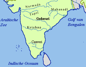
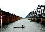
The district has two river basins, the Godavari and the Krishna. Major parts of the district is covered by Godavari basin, drained by its two major tributaries the Manjra and the Karanja rivers. The Godavari basin extends to over 4,411 km2 of which Manjra covers up to 1,989 km2 and Karanja up to 2,422 km2. The Krishna basin covers 585 km2 of which Mullamari river basin covers 249 km2 and Gandarinala river basin covers 336 km2 The Manjra river is perennial river flows over a distance of 155 km in the central part of the district and flows in eastern direction with a meandering course. The Karanja river flows in northwestern direction for 74 km with Karanja reservoir being major water source. The river Mullamari takes its origin near Matala village of Basavakalyan taluk flows from west to east for a length of 38 km and then flows into Kalaburgi district and joins the river Kagna. The Kagna river is one of the main tributary of Bhima river. Besides, there are several streams, which are of ephemeral in nature. The drainage pattern in the district varies from sub-dendritic to dendritic and some streams have a sub parallel drainage to the main river.[9]
These rivers and their rivulets are not navigable.

Rain
The average annual rainfall at Bidar is 885.8mm. About 81% of annual rainfall is received during the period from June to September. Maximum rainfall is recorded in the month of September. The variation in rainfall from year to year is large and the district is drought-prone. The average numbers of rainy days in the district are 52.
The relative humidity is high during the southwest monsoon, being between 65% to 75%. Summer is the driest part of the year, when the relative humidity in the afternoon is between 30% and 40%.
Winds are generally moderate in strength with some increase in force during the latter half of the summer season and during the monsoon. During the southwest monsoon season, winds mainly blow between the southwest and northeast directions. In the post monsoon season, winds blow predominantly between north and east directions. During the winter season winds are variable in directions
Forests
Bidar Forest Division is the northern most division of Karnataka encompassing the whole of Bidar district and 31 villages of the adjoining Gulbarga district. Classified under Reserve forests, Protected forests and Unclassed forests, Bidar Forest Division is having 435.92 km2. of area under forest cover.[13]
The forests are mainly dry deciduous and have scrub type vegetation. Over the years, almost all the forest areas have been worked on one or more times resulting in large expanses of man made forests consisting mostly of Eucalyptus, Acacia auriculiformis, Glyricidia, and miscellaneous species such as Hardwickia, Albizzia, Azadirachta, Pterocarpus, etc.[13] The majority of these plantations are successful. Because of the sustained efforts of the forest department, the forest cover in the district has increased by about 4% as reported by the Hyderabad-based National Remote Sensing Agency.
Teak is found mixed with dry deciduous species. Ground cover is scanty and seedlings regeneration is practically absent. Thorny plants occur and tend to increase in proportion with heavy grazing, etc., to which most of the area is subjected. Ground cover is scanty and seedlings regeneration is practically absent. Grazing incidence is heavy. This type of forest is found in Changlair, Karpakpalli and Karakanalli forests.
Acacia catechu, Acacia leucophloea, Wrightia tinctoria, Zizyphus xylopyrus, Cassia fistula, Annona species, Azadirachta indica, Butea monosperma, Chloroxylon switenia, Albizzia amara, etc. are widely seen in Ladwanthi, Kohinoor, Algood and Manhalli forests Basavakalyan range.
Out of the total forest area of 435 km2 in the division more than 50 percent of the area is concentrated in Humnabad range, followed by Bidar range (20%) and Basavakalyan range. Aurad range is having the smallest area under the forest.[13]
Viewed from the point of area under forests, the out-turn of forest produce and the revenue from forests Bidar division is not endowed with quality forest wealth. Out of the total geographical area of 5448 km2 in Bidar division an extent of 435.9 km2 under forests. In other words, this accounts for about 8.5 percent of the total geographical area. Area under forests in the division is very much below the state average.
Medicinal Plant Conservation Area
In Karpakpalli village of Humnabad taluk, a Medicinal Plant Conservation Area (MPCA) has been established. It is apart of Saidapur Reserve forest. Situated at an altitude of 600–700 meters the MPCA is spread over about 150 hectares. The terrain is undulating and vegetation is dry deciduous scrub type. It is the northern most member of the Medicinal plants conservation network established by the Karnataka forest department and the Foundation for Revitalization of Local Health Traditions (FRLHT) jointly. The uniqueness of the MPCA is characterized by representation of the medicinal flora of the driest regions of the southern India.
The vegetation is dry deciduous scrub type, with most of it being stunted due to harsh climatic and edaphic factors. The terrain is criss-crossed by a few small seasonal streams, which go dry soon after the monsoon. The MPCA offers a tapestry of about 289 species of flowering plants. Common tree species in the drier parts are Albizzia amara, Madhuca latifolia, Buchnania lanzan, Butea frondosa, Ficus bengalensis and Wrightia sp. etc., Along the nallahs occur Terminalia arjuna and Syzigium sp. shrubs include Gymnosporia, lxora, Nyctanthes and Nizyphus oenopia etc.
Overall about 193 medicinal plant species area found in the MPCA. It is home to highly endangered species Pterocarpus santalinus the Rakta chandana and Gloriosa superba. Most important are Hollorhina antidyssentrica, Santalum album etc.; Presence of large number of medicinal plant species has helped the locals to take the advice of Nati vaidyas in the surrounding villages in case of any health problem. It is home to highly endangered species Pterocarpus santalinus the Rakta chandana and Gloriosa superba.
The area being highly valuable to the locals for medicinal plants a local initiative to protect the highly valuable plant species in Karpakpally MPCA with active participation of the local villagers is also underway. An NGO Kriyasheela Geleyaru is involved in organizing local children and women disseminating knowledge about the locally available medicinal plants and the need to protect the eco system.[13]
Red sanders
The southern and eastern parts of Bidar district support the growth of red sanders (Pterocarpus santalinus) which is highly valued. Owing to its dark red to almost black wood it is largely used for carving and ornamental work. The wood is in much demand for carved house posts. It is used in making musical instruments in Japan. Red sanders timber is a very good foreign exchange earner.
Red sanders has a very restricted natural range extending over an area of only 6000 sq. milies in south eastern portion of the Indian Peninsula. Its principal home is in Sheshachalam hills of Cuddapah district of Andhra Pradesh and North Arcot district of Tamil Nandu besides southern and eastern parts of Bidar district.[13]
Wildlife
The northern part of the state is generally considered to be a dry belt, devoid of water bodies, vegetation and wildlife. But the surroundings of Bidar, the northernmost district, seems to be an exception.
There are no wildlife sanctuaries and national parks in the Bidar Forest Division. However leopards may be seen occasionally far from human habitations. Langurs, wolves, spotted deer, wild boar,[14] hares,[14] porcupines,[14] foxes,[14] wild cats and jackals are also seen.[13] In Karnataka, After Ranebennur Blackbuck Sanctuary in Haveri district and Jayamangali Blackbuck Conservation Reserve in Tumkur district, a sizeable population of near threatened species of blackbucks is found in the plains of Bidar District.[14]
The existing natural water holes have to be developed by desilting. Herds of spotted deer and peafowl are found in Kamathana, Chitta, Shahapur and Godepalli forest areas.[13] Poaching of deer in these areas is common. Hence, protection needs to be ensured. Creation of wild life sanctuary may be contemplated in future when the number of wildlife increases. Some of the bigger sized trees act as a roosting place for peacock, which is the national bird of India. The following forests support considerable wildlife
- Narayanapur reserved forest in Basavakalyan range.
- Dubalgundi and Benchincholi forest blocks in Humnabad range.
- Kosam,Khanapur and Dhanura forests in Bhalki range.
In addition to commonly found avians, varied bird life like green bee eaters,[14] robins,[14] sunbirds,[14] red vented bulbuls,[14] egrets, herons, ducks,[14] cormorants,[14] kingfishers,[14] kites, eagles, peafowls and partridges[14] etc. can be seen. Rare birds and endangered species such as Indian coursers[14] and vultures are often sighted.
Winter sees the arrival of aquatic migratory birds from regions as far as Siberia, Mongolia and Alaska. One study has recorded 74 species of aquatic birds in Bidar district, of which 32 species are migratory. Tanks and other water bodies at places like Janawada, Elaspur, Solpur, Papnash, Hallikhed, Tripurant etc., in the district which have large quantity of fish and other aquatic animals, provide feeding grounds to various migratory birds like, black-necked stork, great stone plover, marsh sandpiper, painted snipe, etc.[15]
Demographics
According to the 2011 census Bidar district has a population of 1,700,018,[16] roughly equal to the nation of The Gambia[17] or the US state of Nebraska.[18] This gives it a ranking of 287th in India (out of a total of 640). Bidar district accounts for 2.84% of total area of the state and it is home for 2.78% of the total population in the state. The district has a population density of 312 inhabitants per square kilometre (810/sq mi) .[16] Its population growth rate over the decade 2001-2011 was 13.16%.[16] Bidar has a sex ratio of 952 females for every 1000 males,[16] and a literacy rate of 71.01%.[16]
Most of the north Karnataka is a fusion of the Dravidian and Aryan races.[5] Medieval times also saw a continuous influx of Turks, Moghals, Iranians, Afghans and Arabs.
Art and culture
Bidriware

Bidar is well known for its local artifact - the Bidriware, which is a type of encrusted metal ware. An alloy composing of zinc and copper is the major constituent of Bidriware. Artistic designs are inlaid in silver.[19]
Sandalwood carving
A locally less-known but globally renowned sandalwood carving at Bakchodi village in the district produces woodworks of Buddha heads, handicraft items and prayer beads carved in red sandalwood to many countries in Europe and Asia.[20]
Attractions / amenities
Religious places
- Narasimha Jharni Cave Temple, Bidar
- Gurudwara Nanak Jhira Sahib, Bidar
- Shri Manik Prabhu Devasthanam, Manik Nagar (Humnabad Tq.)
- Shri Mailar Mallanna Devasthana, Mailar, Khanapur (Bidar Tq)
Economy
In 2006 the Ministry of Panchayati Raj named Bidar one of the country's 250 most backward districts (out of a total of 640).[21] It is one of the five districts in Karnataka currently receiving funds from the Backward Regions Grant Fund Programme (BRGF).[21]
Agriculture
Agriculture is the main occupation in rural parts of the district. Greengram, bengalgram, blackgram, paddy, groundnut, wheat, redgram, sugarcane and chillies are other agricultural crops.
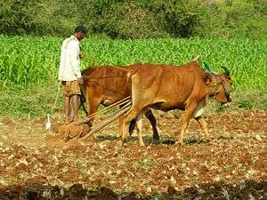
Agriculture in Bidar had had its own specific form. Drawing on the specification of the local ecology, agriculture was mostly dry cultivation or rain-dependent cultivation in which a wide variety of local sorghum (Jola, the staple grain) was grown in combination with pulses, oil seeds, wheat and other cereals. Though cultivation was restricted to two periods rabi or winter cultivation (August–January), and kharif or summer cultivation (June–September), care was taken to cultivate green manure crops of Sannhemp[22] and Diancha. The cultivation and use of such manure crops helped agriculturists retain the fertility of the soil, decreased the chances of external pests and diseases entering the fields, and enabled agriculturists to be self-reliant for a very significant agricultural input. Even by 1970s little commercial or inorganic manure and fertilisers were used.[23]
But the agriculture of Bidar, like that of many other semi-arid regions which produced dry cereals, was considered to be "low productive" and has been subject to a variety of "development programmes" that have drawn, largely, on the agenda of the Green Revolution. Drawing on programmes and policies that emphasise the need to increase agricultural productivity, the state has promoted a model of agriculture in the region that draws primarily on the model of agriculture developed for wet regions and for commercial cultivation.[23]
In 1966-67, high-yielding varieties of seeds for sorghum, paddy, wheat and sugarcane were introduced. Gradually between the late 1960s and mid-1970s hybrid varieties of seeds for other crops such as cotton, pulses and sunflower were introduced. The cultivation of tur or toghri (red gram) as a commercial crop became the primary agricultural agenda in the region, A significant proportion of land once under multi-crops and dry cultivation (especially sorghum, wheat and oil-seeds) has now been dedicated to the cultivation of pulses, especially that of kadle (Bengal gram), and tur.[23]
The introduction and promotion of modern agriculture result in the development of two key and striking contradictions in the region. Perhaps the most significant contradiction of this is that while there is an alteration in the very foundations and orientations of agricultural cultivation (in the type of crops cultivated, in the new seed varieties, new inputs, etc.,), there is little or no change in the social bases of the agrarian society. That is, though there is an alteration in the physical conduct of agriculture (in the types of crops grown, the cultivation patterns etc.,) it is not matched by any alteration in the ownership patterns of the agrarian society in which the new agriculture is introduced. Though largely a dry cultivation belt with a predominance of small cultivators, there is a schism in the patterns of land ownership.[23]
Given the declining size of landholdings, many small and marginal cultivators resort to renting or sharecropping.
- Social scenario - The introduction of commercial agriculture in this predominantly dry agriculture belt has its impact on the social fabric of the region. Commercial agriculture itself forces agriculturists to submit to the prescriptions of the agricultural extension service, the market, the agri-business agencies and credit institutions and agents. Agriculture is no longer drawn on the established principles of local knowledge and caste and kin-based ties. Instead, agriculture is a form of livelihood, to engage in which individual agriculturists (farmers) depend primarily on their household and family support. As agriculture becomes an externally prescribed form of economic activity there are problems in the dissemination of knowledge, in the conduct of actual agricultural activities and in the understanding and management of situations such as crop loss.[23]
Irrigation
In geo-physical terms Bidar district is part of the semi-arid and drought-prone belt of northern Karnataka and has been susceptible to periodic droughts. Though some 82 percent of the total land are cultivated, only eight (8) percent of its total cultivable area is irrigated.[23]
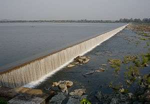
The two major irrigation projects, Karanja started in 1963 and Chulkinala started in 1972, are yet to be completed. Only 2,097 hectares (8.10 sq mi) are irrigated by canals and tanks, while the rest, of about 30,892 hectares (119.27 sq mi), are irrigated by wells and tube wells. The state of incompletion and disrepair (of the little that has been completed) of the two large irrigation projects are reflect the extent of state support for the region.[23]
Government

Administration
The district has five talukas, Bidar, Humnabad, Bhalki, Aurad, and Basavakalyan.
Legislative Assembly seats
In the Karnataka Legislative Assembly, Bidar district is represented through six members elected from the following assembly segments:
- Bidar
- Bidar South
- Bhalki
- BasavaKalyan
- Aurad
- Humnabad
In the Indian Parliament, (Lok Sabha), the district it is represented by a single member.
References
- 1 2 3 4 5 6 "Bidar District : Census 2011 data". Census2011.co.in. Retrieved 14 March 2015.
- ↑ average elevation of the district
- ↑ Directorate of Economics and Statistics, B'luru, 2013
- ↑ Karnataka Gazetteer (Second ed.). Govt. of Karnataka. 1 January 1983.
- 1 2 3 4 Santosh Tippanna; Sarvodaya S. S. "Socio-Economic And Educational Developments In Bidar District: A Historical Perpective". Monthly Multidisciplinary Research Journal. II (VIII). ISSN 2230-7850.
- ↑ "Travel Blog". Retrieved 22 February 2015.
- ↑ "A BASELINE SURVEY OF MINORITY CONCENTRATION DISTRICTS OF INDIA - Bidar (Karnataka)" (PDF). Retrieved 22 February 2015.
- 1 2 3 4 5 Karnataka Gazetteer. Govt. of Karnataka. 1 January 1982.
- 1 2 3 Ground Water Information Booklet - Bidar District, Karnataka. Ministry of Water Resources, Govt. of India. July 2008.
- ↑ Ghulam Yazdani (10 June 1944). Bidar - Its History and Monuments. Oxford University Press, London.
- ↑ Bidar district official website
- ↑ Bidar district official website
- 1 2 3 4 5 6 7 "Bidar Forests". Bidar District Official Website. Archived from the original on 9 March 2015. Retrieved 14 March 2015.
- 1 2 3 4 5 6 7 8 9 10 11 12 13 14 "Bidar abounds in wildlife". Deccan Herald. 8 April 2014.
- ↑ "Bidar to be abode of migratory birds again". The Hindu. 11 October 2007. Retrieved 15 March 2015.
- 1 2 3 4 5 "District Census 2011". Census2011.co.in. 2011. Retrieved 2011-09-30.
- ↑ US Directorate of Intelligence. "Country Comparison:Population". Retrieved 2011-10-01.
Gambia, The 1,797,860 July 2011 est.
- ↑ "2010 Resident Population Data". U. S. Census Bureau. Archived from the original on January 1, 2011. Retrieved 2011-09-30.
Nebraska 1,826,341
- ↑ "Lightweight Bidriware is his USP". The Hindu. 29 September 2009. Retrieved 16 March 2015.
- ↑ "Bidar brothers become global sandalwood artisans". The Hindu. 27 August 2014. Retrieved 16 March 2015.
- 1 2 Ministry of Panchayati Raj (September 8, 2009). "A Note on the Backward Regions Grant Fund Programme" (PDF). National Institute of Rural Development. Archived from the original (PDF) on April 5, 2012. Retrieved September 27, 2011.
- ↑ SANN HEMP, is called pundi (local language) and is a versatile green bush/shrub the leaves of which make for a nutritious vegetable and the dried stems make good rope.
- 1 2 3 4 5 6 7 Agrarian Distress in Bidar,A R Vasavi, 1999, National Institute of Advanced Studies, Indian Institute of Science Campus, Bengaluru
External links
| Wikimedia Commons has media related to Bidar district. |
| Wikivoyage has a travel guide for Bidar. |
- Bidar district official website
- List Of Cities in Bidar
 |
Nanded district, Maharashtra | Nizamabad district, Telangana | | |
| Latur district, Maharashtra | |
Medak district, Telangana | ||
| ||||
| | ||||
| Osmanabad district, Maharashtra | Gulbarga district |
| Rivers |
|    | |||||||||||||||||||||||||
|---|---|---|---|---|---|---|---|---|---|---|---|---|---|---|---|---|---|---|---|---|---|---|---|---|---|---|---|
| Dams, barrages | |||||||||||||||||||||||||||
| Geographical features / regions | |||||||||||||||||||||||||||
| Riparian districts |
| ||||||||||||||||||||||||||
| Cities | |||||||||||||||||||||||||||
| Languages / people | |||||||||||||||||||||||||||
| Coalfields | |||||||||||||||||||||||||||
| Oil / gas fields | |||||||||||||||||||||||||||
| Industries |
| ||||||||||||||||||||||||||
| Transport | |||||||||||||||||||||||||||
| Related topics | |||||||||||||||||||||||||||
| Other basins | |||||||||||||||||||||||||||