Whitegate, County Clare
| Whitegate An Geata Bán | |
|---|---|
| Village | |
 Whitegate Location in Ireland | |
| Coordinates: 52°55′N 8°32′W / 52.91°N 8.53°WCoordinates: 52°55′N 8°32′W / 52.91°N 8.53°W | |
| Country | Ireland |
| Province | Munster |
| County | County Clare |
| Population (2006) | |
| • Urban | 218 |
| Time zone | WET (UTC+0) |
| • Summer (DST) | IST (WEST) (UTC-1) |
| Irish Grid Reference | R746888 |
Whitegate (Irish: An Geata Bán, meaning "the white gate") is a small village on the R352 regional road in northeastern County Clare, Ireland. A tightly knit community shows through even though many of the old buildings are gone. What was once the church has been in disuse for many years and has now become a warehouse and lumberyard. All that is left of the oldest buildings is a small cottage which has crumbled and caved in on the cross-roads.
A new church has been erected and there are many new houses have been built along the main street. Local pubs include The Half Barrel, and The Nightingale.
See also
External links
Places in County Clare | ||
|---|---|---|
| Towns | 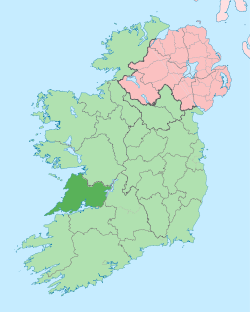 | |
| Villages |
| |
| Regions | ||
| Islands | ||
| ||
This article is issued from Wikipedia - version of the 9/3/2014. The text is available under the Creative Commons Attribution/Share Alike but additional terms may apply for the media files.