The Burren
| Burren | |
|---|---|
|
Native name Irish: Boireann | |
|
The karst landscape of the Burren | |
| Type | Cultural |
| Location | County Clare, Ireland |
| Coordinates | 53°06′29″N 9°02′20″W / 53.1080451°N 9.0389585°WCoordinates: 53°06′29″N 9°02′20″W / 53.1080451°N 9.0389585°W |
| Official name: Global Geoparks Network (GGN) | |
| Designated | 17 November 2015 |
| Reference no. | 5522 |
The Burren (Irish: Boireann, meaning "great rock") is a karst landscape in County Clare, Ireland. It measures approximately 250 square kilometres and is enclosed roughly within the circle made by the villages of Ballyvaughan, Kinvara, Tubber, Corofin, Kilfenora and Lisdoonvarna. The Burren National Park is one of six National Parks in Ireland and the smallest in size (15 km2). The Burren Centre is located in Kilfenora.[1]

History

The Burren area formed part of the territory of Corco Modhruadh, meaning "seed or people of Modhruadh" which was coextensive with the diocese of Kilfenora. At some point around the 12th century, the territory was divided in two: Corco Modhruadh Iartharach ("Western Corcomroe") and Corco Modhruadh Oirthearach ("Eastern Corcomroe") also known as Boireann which in the late 16th century became the English administrative baronies of Corcomroe and Burren respectively. The O'Loughlin (Ó Lochlainn) clan ruled Boireann down to the mid-17th century from their chief residence at Gragans Castle (towerhouse not the house of the same name). The chief of the family was known in later times as the 'Prince of Burren' and clan members were buried in the family tomb near the altar of Corcomroe Abbey. Their kinsmen the O'Connor (Ó Conchubhair) clan ruled Corco Modhruadh Iartharach from Dough Castle near Liscannor. The villages and towns found within the medieval territory of Boireann include Lisdoonvarna, Ballyvaughan, New Quay / Burrin (Burren), Noughaval, Bealaclugga (Bellharbour), Carron and Fanore / Craggagh.
The Burren is rich with historical and archaeological sites. There are more than 90 megalithic tombs in the area, portal dolmens (including Poulnabrone dolmen), several high crosses in the village of Kilfenora, and a number of ringforts - among them the triple ring fort Cahercommaun on the edge of an inland cliff, and the exceptionally well-preserved Caherconnell Stone Fort. Corcomroe Abbey is one of the area's main scenic attractions.
Geology
.jpg)
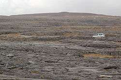
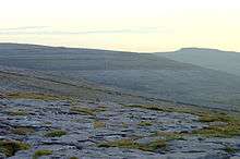
The rolling hills of The Burren are composed of limestone pavements with criss-crossing cracks known as "grikes", leaving isolated rocks called "clints". The region supports arctic, Mediterranean and alpine plants side-by-side, due to the unusual environment. The limestones, which date from the Visean stage of the Lower Carboniferous, formed as sediments in a tropical sea approximately 350 million years ago. The strata contain fossil corals, crinoids, sea urchins and ammonites.
Glaciation during the Quaternary period facilitated greater denudation. The result is that The Burren is one of the finest examples of a glacio-karst landscape in the world. The effects of the last glacial period (the Midlandian) are most in evidence, with The Burren overrun by ice during this glaciation. The impact of earlier karstification (solutional erosion) has been eliminated by the last glacial period. So any surface karstification now seen dates from approximately 10,000 years ago and The Burren karst is thus recent. Solutional processes have widened and deepened the grikes of the limestone pavement. Pre-existing lines of weakness in the rock (vertical joints) contribute to the formation of extensive fissures separated by clints (flat pavement like slabs). The rock karstification facilitates the formation of subterranean drainage.
Climate and agriculture
The Burren has an unusually temperate climate. Average air temperatures range from 15 °C in July to 6 °C in January. The soil temperature does not usually drop below 6 °C (end 2010 recorded a very unusual prolonged period of snow). Since grass will grow once the temperature rises above 6 °C, this means that The Burren (like the neighbouring Aran Islands) has one of the longest growing seasons in Ireland or Britain, and supports diverse and rich plant growth. Late May is the sunniest time,[2] and also likely the best time to view flowers, with the gentians and avens peaking (but orchid species blooming later).
During counter-guerrilla operations in The Burren in 1651-52, Edmund Ludlow stated, "(Burren) is a country where there is not enough water to drown a man, wood enough to hang one, nor earth enough to bury him...... and yet their cattle are very fat; for the grass growing in turfs of earth, of two or three foot square, that lie between the rocks, which are of limestone, is very sweet and nourishing."
Flora and fauna
The Burren is renowned for its remarkable assemblage of plants and animals.[3] The region supports many rare Irish species, some of which are only found in this area. Others occur in similar karst areas in western Ireland.
Three quarters of Ireland's species of flowers are found in The Burren. The grikes (crevices) provide moist shelter, supporting a wide range of plants including dwarf shrubs. Where the surface of the pavement is shattered into gravel, many of the hardier Arctic or Alpine plants can be found, when the limestone pavement is covered by a thin layer of soil, patches of grass are seen, interspersed with herbaceous plants. Among the flowers recorded from The Burren is the spring gentian, an alpine plant with bright blue flowers that are used as a symbol for the area by the tourist board. The Irish orchid (Neotinea intacta) and bloody cranesbill (Geranium sanguineum) also occur there.[4]
Notable insects present in The Burren include the butterflies the pearl-bordered fritillary (Boloria euphrosyne), brown hairstreak (Thecla betulae), marsh fritillary (Euphydryas aurinia) and wood white (Leptidea sinapis); the moths, the Burren green (Calamia tridens), Irish annulet (Gnophos dumetata) and transparent burnet (Zygaena purpuralis); the hoverfly Doros profuges and the water-beetle Ochthebius nilssoni. This last species is known from just five sites in the world, its type locality in northern Sweden and four marl lakes in The Burren.
The Burren is one of the main breeding areas in Ireland of the European pine marten.
EcoTourism in the Burren
Ecotourism is an important factor in The Burren, with many organisations involved in it. The vulnarable landscape needs all the protection it can get, while at the same time it should provide an income for the local inhabitants and cope with the increased visitor numbers. sustainable ecotourism and independent "'EcoTourism Certification" for companies was the answer to cope with those conflicting demands.[5]
Culture
The Burren has a long history of traditional Irish music. It is particularly known for the "West Clare Style" of concertina playing and the music festival in Doolin and Corofin.
Sport
The Burren's many limestone cliffs, particularly the sea-cliffs at Ailladie, are popular with rock-climbers.[6] For cavers, there are a number of charted caves in the area, notably Pollnagollum. Doolin is a popular "base camp" for cavers, and is home to one of the two main cave-rescue stores of the Irish Cave Rescue Organisation.
Gallery
 Native flowers and rock formations
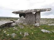 Poulnabrone portal tomb
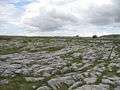 The Burren landscape
 Poulnabrone Portal Tomb
 The Burren fence
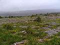 Karst meadow
 Stone monument
 Karst dome near Kilkeedy Parish - eastern part of The Burren
See also
- Aillwee Cave
- Burren Action Group
- Cliffs of Moher
- Turlough (lake)
- Mullaghmore, County Clare
- Newtown Castle
- Temple Cronan
- Wild Atlantic Way
- Corofin, County Clare
References
- ↑ Burren Centre
- ↑ http://www.met.ie
- ↑ "Noteworthy Plants of the Burren: A Catalogue Raisonné". JSTOR 20494847.
- ↑ Clements, P. 2011 Burren Country, Travels through an Irish Limestone Landscape. The Collins Press. ISBN 9781848891173
- ↑ "Burren EcoTourism | The Burren Centre". www.theburrencentre.ie. Retrieved 2016-12-02.
- ↑ "Irish Climbing Online Wiki".
Notes
- ^ BBC: The Flowers of the Burren, County Clare, Ireland
- ^ A similar quote "The Burren affordeth not a piece of timber sufficient to hang a man, water in any one place to drown a man, or earth enough in any one part to bury him." can be found in "The Journal of Thomas Dineley", 1681, in the National Library of Ireland. Extracts from his journal, including his account of the Clare section of his journey, were published in the Journal of the Royal Society of Antiquaries, 6 (1867). These appear in an online version in "The History and Topography of the County of Clare" by James Frost Part II. History of Thomond Chapter 28 Barony of Burren
Bibliography
- McCarthy, P.M. and Mitchell, M.E. 1988. Lichens of the Burren Hills and the Aran Islands. Galway. Officina Typographica.
- Bilton, D.T., 1988. A survey of aquatic Coleoptera in Central Ireland and the Burren. Bulletin of the Irish biogeographical Society 11: 77-94.
- Foster, G.N., Nelson, B.H. & O Connor, A. 2009. Ireland Red List No. 1 - Water beetles. National Parks and Wildlife Service, Department of Environment, Heritage and Local Government, Dublin.
- O'Callagan, E., Foster, G.N., Bilton, D.T. & Reynolds, J.D. 2009 Ochthebius nilssoni Hebauer new for Ireland (Coleoptera: Hydraenidae), including a key to Irish Ochthebius and Enicocerus. Irish Naturalists' Journal 30: 19-23
- Sheehy Skeffington, M., Moran, J., O Connor, Á., Regan, E., Coxon, C. E., Scott, N. E. & Gormally, M. 2006. Turloughs – Ireland’s unique wetland habitat. Biological Conservation 133: 265-290.
- Anon. The Burren: A Guide. Shannonside Mid Western Regional Tourism Organization Ltd., 62, O'Connell St., Limerick.
- E. C. Nelson. Checklist of Plants of The Burren Region.
- D.A. Webb & M.J.P. Scannell. 1983 Flora of Connemara and The Burren. Royal Dublin Society & Cambridge University Press.
- T. J. Westropp. 1999. Archaeology of The Burren: Prehistoric Forts and Dolmens in North Clare. Clasp Press (reprint).
- D’Arcy & Hayward. The Natural History of The Burren.
- E.C. Nelson & W. Walsh. The Burren Wildflowers, Conservancy of The Burren, An Bothan, Ballyvaughan, Co. Clare.
- Hennessy, R., McNamara, M., & Hoctor, Z., 2010 Stone, Water & Ice: A Geology Trip Through the Burren. Burren Connect Project, pp. 64
External links
| Wikimedia Commons has media related to The Burren. |