Tulla
| Tulla An Tulach | |
|---|---|
| Town | |
|
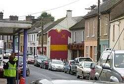
Street scene in Tulla | |
 Tulla Location in Ireland | |
| Coordinates: 52°52′08″N 8°45′36″W / 52.869°N 8.760°WCoordinates: 52°52′08″N 8°45′36″W / 52.869°N 8.760°W | |
| Country | Ireland |
| Province | Munster |
| County | County Clare |
| Elevation | 53 m (174 ft) |
| Population (2011)[1] | |
| • Total | 662 |
| Irish Grid Reference | R484798 |
| Website |
www |
Tulla (Irish: An Tulach, meaning "hill") is a town in County Clare, Ireland. The town is the commercial centre for Tulla parish and the surrounding area, and is around 15 km east of Ennis. Tulla church was founded about 620 by Mochuille and the town received its town charter in the 13th century. The name may also refer to two half-baronies around the town.
Location
Tulla is a town and a parish in the barony of Tulla Upper.[2] It is 10 miles (16 km) east of Ennis. The parish has many ruins of old castles. On the hill on which the town of Tulla stands there is the ruin of an old abbey and of a druidical altar. The parish covers 15,304 acres (6,193 ha), including a large area of mountain and some bog. There are limestone caverns at Kiltanon, holding many petrified shells.[3] The Roman Catholic parish churches are Saints Peter & Paul in Tulla, St James in Knockjames and the Immaculate Conception in Drumcharley.[4]
The townlands are Affick, Annagh, Ardbooly Lower, Ardbooly Upper, Ballyblood, Ballyoughtra, Ballyoughtra (O'Callaghan), Ballyslattery or Newgrove, Bunavory, Cloghaun, Cloonaleary, Cloondanagh, Cloondoorney Beg, Cloondoorney More, Cloonteen, Commons, Cragg, Craggaunkeel, Cragroe, Cutteen Beg, Cutteen More, Derrykeadgran, Derrymore East, Derrymore West, Derryulk Lower, Derryulk Middle, Derryulk Upper, Doonaun, Drumcharley, Drummaghmartin, Drumullan, Eyrehill, Fomerla, Fortane Beg, Fortane More, Furhee, Garruragh, Glendree, Gorteennaguppoge, Gorteenaneelig, Kilboggoon, Kilduff Lower, Kilduff Middle, Kilduff Upper, Kilmore, Kiltanon, Knockadoon, Knockdoocunna, Knockdrumleague, Lahardaun, Lecarrow North, Lecarrow South, Liscullaun, Lisduff, Lissofin, Loughaun North, Loughaun South, Maryfort or Lismeehan, Milltown, Moymore, Poulaforia, Rannagh, Rine, Rosslara, Tome, Tulla, Tyredagh Lower, Tyredagh Upper, Uggoon Lower and Uggoon Upper.[5]
History
In 1837 Tulla Samuel Lewis described Tulla. "This place appears to have some claims to antiquity; there are numerous remains of ancient castles, formerly the residences of its landed proprietors. The town is pleasantly situated on a hill, and is surrounded with highly interesting scenery, enlivened with numerous elegant seats and pleasing villas. The principal trade is derived from its situation on a public thoroughfare, and is chiefly confined to the supply of the surrounding neighbourhood."[3]
Notable persons and institutions
Theophilus O'Flanagan, born in Tulla, Gaelic scholar and founder member of the Gaelic Society and editor of its Transactions.[6]
- The Tulla Céilí Band, Irish Céilidh band active since 1946
Demographics
In 1845, the population of the Tulla parish was estimated at around 9,000. But by 1851 the population had decreased to roughly 6,700.
The current population of the town of Tulla is 645.
Sport
Tulla has a GAA (Gaelic Athletic Association) Club which was founded in 1887. Its home pitch is Dr Daly Memorial Park, named after the famous goalkeeper, Dr. Tommy Daly. Tulla also has a soccer club called "Tulla United A.F.C", which was founded in 1970.
Music
Tulla is also notable for a famous céilí band, the Tulla Céilí Band.[7] and famous pipe band, St Patrick's Pipe Band or known locally as Tulla Pipe Band which was formed on 7 January 1936.
See also
References
- ↑ "Census 2006 – Volume 1 – Population Classified by Area" (PDF). Central Statistics Office Census 2006 Reports. Central Statistics Office Ireland. April 2007. Retrieved 2011-05-07.
- ↑ "Tulla, Tullagh, or Tulloh". Parliamentary Gazeteer of Ireland. 1845. Retrieved 2014-04-01.
- 1 2 Lewis, Samuel (1837, 1995). County Clare, A History and Topography. Ennis: CLASP Press. pp. 123–124. ISBN 1-900545-00-4. Retrieved 2014-04-01. Check date values in:
|date=(help) - ↑ "Tulla Churches". Diocese of Killaloe. Retrieved 2014-04-01.
- ↑ "Map of Tulla Parish showing Townlands". Clare County Library. Retrieved 2014-04-01.
- ↑ http://www.ricorso.net/rx/az-data/authors/o/OFlanagan_T/life.htm
- ↑ "Clare Places - Tulla: Historical Background". Clarelibrary.ie. Retrieved 2014-03-03.
External links
Places in County Clare | ||
|---|---|---|
| Towns | 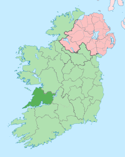 | |
| Villages |
| |
| Regions | ||
| Islands | ||
| ||
| Province | |
|---|---|
| Ordinaries | |
| Cathedral church | |
| Parishes | |
| |