Knock, County Clare
| Knock An Cnoc | |
|---|---|
| Village | |
|
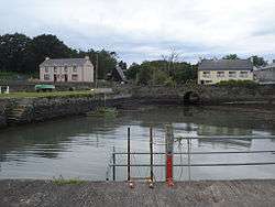
The harbour of Knock | |
 Knock Location in Ireland | |
| Coordinates: 52°37′N 9°14′W / 52.62°N 9.24°W | |
| Country | Ireland |
| Province | Munster |
| County | County Clare |
| Elevation | 5 m (16 ft) |
| Time zone | WET (UTC+0) |
| • Summer (DST) | IST (WEST) (UTC-1) |
| Irish Grid Reference | R097537 |
Knock (Irish: An Cnoc) is a village in County Clare, Ireland. The village is located at the northern banks of the Clonderalaw Bay, a bay connected with the Shannon, and the R486 is passing through the village.
According to the geographer Samuel Lewis the parish counted 180 inhabitants in 1837.[1] The Census 2006 showed ongoing depopulating, returning 228 inhabitants for Knock, compared with 252 inhabitants in 2002[2]
The river Crompaun which enters the Shannon near Knock, was the subject of questions in the Dáil Éireann in 1949. Problem was that 14 sluices had broken down. The Commissioners of Public Works was not responsible for the repair, according to minister Michael Donnelan.[3] The fate of the sluices is unknown.
Notable people
- Ellen Hanley – The unfortunate subject of the play The Colleen Bawn. After being murdered by her husband, she washed up nearby and was buried in Burrane Cemetery near Knock.[4]
See also
References
- ↑ County Clare: A History and Topography 1837 by Samuel Lewis
- ↑ Census 2006
- ↑ Broken Sluices at Knock, County Clare
- ↑ The Colleen Bawn (1803–1819)
Places in County Clare | ||
|---|---|---|
| Towns | 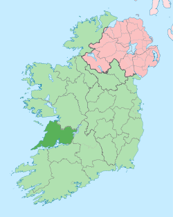 | |
| Villages |
| |
| Regions | ||
| Islands | ||
| ||
Coordinates: 52°37′39.35″N 9°19′53.84″W / 52.6275972°N 9.3316222°W