White Township, New Jersey
| White Township, New Jersey | |
|---|---|
| Township | |
| Township of White | |
|
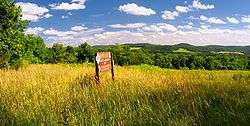
Beaver Brook Wildlife Management Area in White Township | |
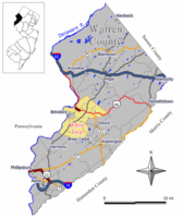 Map of White Township in Warren County. Inset: Location of Warren County highlighted in the State of New Jersey. | |
 Census Bureau map of White Township, New Jersey | |
| Coordinates: 40°49′17″N 75°01′59″W / 40.821516°N 75.033111°WCoordinates: 40°49′17″N 75°01′59″W / 40.821516°N 75.033111°W[1][2] | |
| Country |
|
| State |
|
| County | Warren |
| Incorporated | April 9, 1913 |
| Named for | Alexander White |
| Government[3] | |
| • Type | Township |
| • Body | Township Council |
| • Mayor | Jeff Herb (R, term ends December 31, 2016)[4][5] |
| • Clerk | Kathleen R. Reinalda[6] |
| Area[1] | |
| • Total | 27.632 sq mi (71.565 km2) |
| • Land | 27.152 sq mi (70.322 km2) |
| • Water | 0.480 sq mi (1.243 km2) 1.74% |
| Area rank |
98th of 566 in state 4th of 22 in county[1] |
| Elevation[7] | 525 ft (160 m) |
| Population (2010)[8][9][10] | |
| • Total | 4,882 |
| • Estimate (2015)[11] | 4,743 |
| • Rank |
382nd of 566 in state 10th of 22 in county[12] |
| • Density | 179.8/sq mi (69.4/km2) |
| • Density rank |
516th of 566 in state 16th of 22 in county[12] |
| Time zone | Eastern (EST) (UTC-5) |
| • Summer (DST) | Eastern (EDT) (UTC-4) |
| ZIP code | 07823 - Belvidere[13] |
| Area code(s) | 908[14] |
| FIPS code | 3404180570[1][15][16] |
| GNIS feature ID | 0882246[17] |
| Website |
whitetwp-nj |
White Township is a township in Warren County, New Jersey, United States. As of the 2010 United States Census, the township's population was 4,882,[8][9][10] reflecting an increase of 637 (+15.0%) from the 4,245 counted in the 2000 Census, which had in turn increased by 642 (+17.8%) from the 3,603 counted in the 1990 Census.[18] It is part of the easternmost region of the Lehigh Valley.
White Township was incorporated as a township by an act of the New Jersey Legislature on April 9, 1913, from portions of Oxford Township, based on the results of a referendum held on May 1, 1913, making it the second-youngest township in the county.[19][20] The township was named after Alexander White, who came to the area sometime before 1760 and built a stone mansion called "The White House" near a place called Roxburg.[21][22]
Geography
According to the United States Census Bureau, the township had a total area of 27.632 square miles (71.565 km2), including 27.152 square miles (70.322 km2) of land and 0.480 square miles (1.243 km2) of water (1.74%).[1][2] The township is located in the Kittatinny Valley which is a section of the Great Appalachian Valley that stretches for 700 miles (1,100 km) from Canada to Alabama.
Bridgeville (with a 2010 Census population of 106[23]), Brookfield (675[24]) and Buttzville (146[25]) are census-designated places and unincorporated communities located within the township.[26][27][28]
Other unincorporated communities, localities and place names located partially or completely within the township include Cornish, Foul Rift, Hazen, Little York, Manunka Chunk, Sarepta and Summerfield.[29]
Mount No More is a mountain that is part of the New York–New Jersey Highlands of the Appalachian Mountains. The summit rises to 1,142 feet (348 m).[30]
Demographics
| Historical population | |||
|---|---|---|---|
| Census | Pop. | %± | |
| 1920 | 1,161 | — | |
| 1930 | 1,200 | 3.4% | |
| 1940 | 1,335 | 11.3% | |
| 1950 | 1,536 | 15.1% | |
| 1960 | 1,832 | 19.3% | |
| 1970 | 2,326 | 27.0% | |
| 1980 | 2,748 | 18.1% | |
| 1990 | 3,603 | 31.1% | |
| 2000 | 4,245 | 17.8% | |
| 2010 | 4,882 | 15.0% | |
| Est. 2015 | 4,743 | [11][31] | −2.8% |
| Population sources: 1920[32] 1920-1930[33] 1930-1990[34] 2000[35][36] 2010[8][9][10] | |||
The Township's economic data (as is all of Warren County) is calculated by the US Census Bureau as part of the Allentown-Bethlehem-Easton, PA-NJ Metropolitan Statistical Area.
Census 2010
The 2010 United States Census counted 4,882 people, 2,115 households, and 1,328 families residing in the township. The population density was 179.8 per square mile (69.4/km2). The township contained 2,304 housing units at an average density of 84.9 per square mile (32.8/km2). The racial makeup of the township was 95.33% (4,654) White, 2.03% (99) Black or African American, 0.08% (4) Native American, 0.76% (37) Asian, 0.02% (1) Pacific Islander, 0.78% (38) from other races, and 1.00% (49) from two or more races. Hispanics or Latinos of any race were 2.74% (134) of the population.[8]
Out of a total of 2,115 households, 19.8% had children under the age of 18 living with them, 53.3% were married couples living together, 6.4% had a female householder with no husband present, and 37.2% were non-families. 33.5% of all households were made up of individuals, and 22.4% had someone living alone who was 65 years of age or older. The average household size was 2.23 and the average family size was 2.84.[8]
In the township, 17.0% of the population were under the age of 18, 6.4% from 18 to 24, 16.7% from 25 to 44, 31.0% from 45 to 64, and 28.9% who were 65 years of age or older. The median age was 50.9 years. For every 100 females the census counted 93.9 males, but for 100 females at least 18 years old, it was 91.8 males.[8]
The Census Bureau's 2006-2010 American Community Survey showed that (in 2010 inflation-adjusted dollars) median household income was $68,247 (with a margin of error of +/- $5,170) and the median family income was $81,975 (+/- $7,157). Males had a median income of $57,222 (+/- $15,520) versus $49,022 (+/- $7,746) for females. The per capita income for the borough was $36,964 (+/- $3,448). About 4.2% of families and 4.0% of the population were below the poverty line, including 2.4% of those under age 18 and 3.8% of those age 65 or over.[37]
Census 2000
As of the 2000 United States Census[15] there were 4,245 people, 1,668 households, and 1,179 families residing in the township. The population density was 155.1 people per square mile (59.9/km²). There were 1,770 housing units at an average density of 64.7 per square mile (25.0/km²). The racial makeup of the township was 96.35% White, 1.20% African American, 0.19% Native American, 0.61% Asian, 0.05% Pacific Islander, 0.33% from other races, and 1.27% from two or more races. Hispanic or Latino of any race were 2.12% of the population.[35][36]
There were 1,668 households out of which 28.2% had children under the age of 18 living with them, 60.6% were married couples living together, 7.0% had a female householder with no husband present, and 29.3% were non-families. 25.2% of all households were made up of individuals and 13.8% had someone living alone who was 65 years of age or older. The average household size was 2.47 and the average family size was 2.98.[35][36]
In the township the population was spread out with 22.3% under the age of 18, 5.7% from 18 to 24, 28.2% from 25 to 44, 25.6% from 45 to 64, and 18.2% who were 65 years of age or older. The median age was 42 years. For every 100 females there were 100.1 males. For every 100 females age 18 and over, there were 98.0 males.[35][36]
The median income for a household in the township was $54,732, and the median income for a family was $66,127. Males had a median income of $49,044 versus $35,000 for females. The per capita income for the township was $24,783. About 2.2% of families and 4.9% of the population were below the poverty line, including 3.6% of those under age 18 and 4.8% of those age 65 or over.[35][36]
Government
Local government
White Township is governed under the Township form of government. The governing body is a three-member Township Committee, whose members are elected directly by the voters at-large in partisan elections to serve three-year terms of office on a staggered basis, with either one or two seats coming up for election each year as part of the November general election in a three-year cycle.[3][38] At an annual reorganization meeting, the Township Committee selects one of its members to serve as Mayor.
As of 2016, members of the White Township Committee are Mayor Jeff Herb (R, term on committee and as mayor ends December 31, 2016), Deputy Mayor Samuel Race (R, term on committee ends 2017; term as deputy mayor ends 2016) and Holly Mackey (R, 2018).[4][39][40][41][42][43]
Federal, state and county representation
White Township is located in the 5th Congressional District[44] and is part of New Jersey's 24th state legislative district.[9][45][46] Prior to the 2011 reapportionment following the 2010 Census, White Township had been in the 23rd state legislative district.[47]
New Jersey's Fifth Congressional District is represented by Scott Garrett (R, Wantage Township).[48] New Jersey is represented in the United States Senate by Cory Booker (D, Newark, term ends 2021)[49] and Bob Menendez (D, Paramus, 2019).[50][51]
For the 2016–2017 session (Senate, General Assembly), the 24th Legislative District of the New Jersey Legislature is represented in the State Senate by Steve Oroho (R, Franklin) and in the General Assembly by Parker Space (R, Wantage Township) and Gail Phoebus (R, Andover Township).[52] The Governor of New Jersey is Chris Christie (R, Mendham Township).[53] The Lieutenant Governor of New Jersey is Kim Guadagno (R, Monmouth Beach).[54]
Warren County is governed by a Board of Chosen Freeholders whose three members are chosen at-large on a staggered basis in partisan elections with one seat coming up for election each year as part of the November general election. At an annual reorganization meeting held in the beginning of January, the board selects one of its members to serve as Freeholder Director and other as Deputy Director. As of 2014, Warren County's Freeholders are Freeholder Director Edward J. Smith (R, Asbury / Franklin Township, 2015), Freeholder Deputy Director Richard D. Gardner (R, Asbury / Franklin Township, 2014) and Freeholder Jason Sarnoski (R, Lopatcong Township, 2016).[55] Constitutional officers elected on a countywide basis are County Clerk Patricia J. Kolb (Blairstown Township),[56] Sheriff David Gallant (Blairstown Township) and Surrogate Kevin O'Neill (Hackettstown).[57][58] The County Administrator, Steve Marvin, is responsible for overseeing the day-to-day operation of the county and its departments.[59]
Politics
As of March 23, 2011, there were a total of 3,355 registered voters in White Township, of which 545 (16.2% vs. 21.5% countywide) were registered as Democrats, 1,727 (51.5% vs. 35.3%) were registered as Republicans and 1,077 (32.1% vs. 43.1%) were registered as Unaffiliated. There were 6 voters registered to other parties.[60] Among the township's 2010 Census population, 68.7% (vs. 62.3% in Warren County) were registered to vote, including 82.8% of those ages 18 and over (vs. 81.5% countywide).[60][61] In the 2012 presidential election, Republican Mitt Romney received 1,540 votes here (65.8% vs. 56.0% countywide), ahead of Democrat Barack Obama with 722 votes (30.9% vs. 40.8%) and other candidates with 38 votes (1.6% vs. 1.7%), among the 2,340 ballots cast by the township's 3,383 registered voters, for a turnout of 69.2% (vs. 66.7% in Warren County).[62][63]
In the 2012 presidential election, Republican Mitt Romney received 67.0% of the vote (1,540 cast), ahead of Democrat Barack Obama with 31.4% (722 votes), and other candidates with 1.7% (38 votes), among the 2,340 ballots cast by the township's 3,383 registered voters (40 ballots were spoiled), for a turnout of 69.2%.[64][65] In the 2008 presidential election, Republican John McCain received 1,636 votes (61.6% vs. 55.2% countywide), ahead of Democrat Barack Obama with 891 votes (33.5% vs. 41.4%) and other candidates with 50 votes (1.9% vs. 1.6%), among the 2,656 ballots cast by the township's 3,431 registered voters, for a turnout of 77.4% (vs. 73.4% in Warren County).[66] In the 2004 presidential election, Republican George W. Bush received 1,690 votes (64.6% vs. 61.0% countywide), ahead of Democrat John Kerry with 871 votes (33.3% vs. 37.2%) and other candidates with 44 votes (1.7% vs. 1.3%), among the 2,618 ballots cast by the township's 3,255 registered voters, for a turnout of 80.4% (vs. 76.3% in the whole county).[67]
In the 2013 gubernatorial election, Republican Chris Christie received 79.3% of the vote (1,165 cast), ahead of Democrat Barbara Buono with 17.8% (261 votes), and other candidates with 2.9% (43 votes), among the 1,515 ballots cast by the township's 3,417 registered voters (46 ballots were spoiled), for a turnout of 44.3%.[68][69] In the 2009 gubernatorial election, Republican Chris Christie received 1,189 votes here (62.6% vs. 61.3% countywide), ahead of Democrat Jon Corzine with 440 votes (23.2% vs. 25.7%), Independent Chris Daggett with 210 votes (11.1% vs. 9.8%) and other candidates with 24 votes (1.3% vs. 1.5%), among the 1,899 ballots cast by the township's 3,349 registered voters, yielding a 56.7% turnout (vs. 49.6% in the county).[70]
Education
The White Township School District serves public school students in Kindergarten through eighth grade at White Township Consolidated School.[71] As of the 2011-12 school year, the district's one school had an enrollment of 349 students and 32.2 classroom teachers (on an FTE basis), for a student–teacher ratio of 10.84:1.[72]
Public school students in grades nine through twelve from Harmony Township, Hope Township and White Township attend Belvidere High School as part of sending/receiving relationships with the Belvidere School District.[71][73] As of the 2013-14 school year, the high school had an enrollment of 451 students and 41.0 classroom teachers (on an FTE basis), for a student–teacher ratio of 11.0:1.[74]
Students from the township and from all of Warren County are eligible to attend Ridge and Valley Charter School in Frelinghuysen Township (for grades K-8)[75] or Warren County Technical School in Washington borough (for 9-12),[76] with special education services provided by local districts supplemented throughout the county by the Warren County Special Services School District in Oxford Township (for PreK-12).[71][77][78]
Transportation
As of May 2010, the township had a total of 66.08 miles (106.35 km) of roadways, of which 36.13 miles (58.15 km) were maintained by the municipality, 22.26 miles (35.82 km) by Warren County and 7.69 miles (12.38 km) by the New Jersey Department of Transportation.[79]
U.S. Route 46 passes through the northern part of the township while Route 31 passes through briefly in the east before ending at Route 46. The major county road that passes through is CR 519.
Two limited access roads provide access to the municipality: Interstate 78/U.S. 22 in neighboring Franklin and Interstate 80 in neighboring Knowlton Township and Hope Township.
Landmarks and places of interest
Regular meetings of the Warren County Board of chosen freeholders are held at the Wayne Dumont Jr. Administrative Building in White Township, which also houses most of the administrative offices of Warren County. Part of the Pequest Fish Hatchery also lies within the boundaries of White Township. Four Sisters Winery is located in White Township.
Notable people
People who were born in, residents of, or otherwise closely associated with White Township include:
- Charles W. Buttz (1837–1913), member of the United States House of Representatives from South Carolina.[80]
- John Insley Blair (1802-1899), entrepreneur, railroad magnate, philanthropist and one of the 19th century's wealthiest men.[81]
References
- 1 2 3 4 5 2010 Census Gazetteer Files: New Jersey County Subdivisions, United States Census Bureau. Accessed May 21, 2015.
- 1 2 US Gazetteer files: 2010, 2000, and 1990, United States Census Bureau. Accessed September 4, 2014.
- 1 2 2012 New Jersey Legislative District Data Book, Rutgers University Edward J. Bloustein School of Planning and Public Policy, March 2013, p. 103.
- 1 2 Township Committee Roster, White Township. Accessed August 8, 2016.
- ↑ 2016 New Jersey Mayors Directory, New Jersey Department of Community Affairs. Accessed June 14, 2016.
- ↑ Municipal Clerk, White Township. Accessed August 8, 2016.
- ↑ U.S. Geological Survey Geographic Names Information System: Township of White, Geographic Names Information System. Accessed March 14, 2013.
- 1 2 3 4 5 6 DP-1 - Profile of General Population and Housing Characteristics: 2010 for White township, Warren County, New Jersey, United States Census Bureau. Accessed June 19, 2013.
- 1 2 3 4 Municipalities Grouped by 2011-2020 Legislative Districts, New Jersey Department of State, p. 11. Accessed January 6, 2013.
- 1 2 3 Profile of General Demographic Characteristics: 2010 for White township, New Jersey Department of Labor and Workforce Development. Accessed June 19, 2013.
- 1 2 PEPANNRES - Annual Estimates of the Resident Population: April 1, 2010 to July 1, 2015 - 2015 Population Estimates for New Jersey municipalities, United States Census Bureau. Accessed May 22, 2016.
- 1 2 GCT-PH1 Population, Housing Units, Area, and Density: 2010 - State -- County Subdivision from the 2010 Census Summary File 1 for New Jersey, United States Census Bureau. Accessed June 19, 2013.
- ↑ Look Up a ZIP Code for Belvidere, NJ, United States Postal Service. Accessed June 19, 2013.
- ↑ Area Code Lookup - NPA NXX for Belvider, NJ, Area-Codes.com. Accessed February 10, 2015.
- 1 2 American FactFinder, United States Census Bureau. Accessed September 4, 2014.
- ↑ A Cure for the Common Codes: New Jersey, Missouri Census Data Center. Accessed October 31, 2012.
- ↑ US Board on Geographic Names, United States Geological Survey. Accessed September 4, 2014.
- ↑ Table 7. Population for the Counties and Municipalities in New Jersey: 1990, 2000 and 2010, New Jersey Department of Labor and Workforce Development, February 2011. Accessed June 19, 2013.
- ↑ Snyder, John P. The Story of New Jersey's Civil Boundaries: 1606-1968, Bureau of Geology and Topography; Trenton, New Jersey; 1969. p. 248. Accessed October 25, 2012.
- ↑ Honeyman, A. Van Doren. Northwestern New Jersey--A History of Somerset, Morris, Hunterdon, Warren, and Sussex Counties, Vol. 2, p. 766. Lewis Historical Publishing Co., New York, 1927.
- ↑ Burton, Charlotte. Historical Sites of Warren County. (Warren County Tercentenary Committee and Warren County Board of Chosen Freeholders, 1965) p. 189.
- ↑ Hutchinson, Viola L. The Origin of New Jersey Place Names, New Jersey Public Library Commission, May 1945. Accessed October 29, 2015.
- ↑ DP-1 - Profile of General Population and Housing Characteristics: 2010 Demographic Profile Data for Bridgeville CDP, New Jersey, United States Census Bureau. Accessed June 19, 2013.
- ↑ DP-1 - Profile of General Population and Housing Characteristics: 2010 Demographic Profile Data for Brookfield CDP, New Jersey, United States Census Bureau. Accessed June 19, 2013.
- ↑ DP-1 - Profile of General Population and Housing Characteristics: 2010 Demographic Profile Data for Buttzville CDP, New Jersey, United States Census Bureau. Accessed June 19, 2013.
- ↑ GCT-PH1 - Population, Housing Units, Area, and Density: 2010 - County -- County Subdivision and Place from the 2010 Census Summary File 1 for Warren County, New Jersey, United States Census Bureau. Accessed June 19, 2013.
- ↑ 2006-2010 American Community Survey Geography for New Jersey, United States Census Bureau. Accessed June 19, 2013.
- ↑ New Jersey: 2010 - Population and Housing Unit Counts - 2010 Census of Population and Housing (CPH-2-32), United States Census Bureau, p. III-5, August 2012. Accessed June 19, 2013.
- ↑ Locality Search, State of New Jersey. Accessed April 29, 2015.
- ↑ Feature Detail Report for: Mount No More, Geographic Names Information System. Accessed October 29, 2015.
- ↑ Census Estimates for New Jersey April 1, 2010 to July 1, 2015, United States Census Bureau. Accessed May 22, 2016.
- ↑ Compendium of censuses 1726-1905: together with the tabulated returns of 1905, New Jersey Department of State, 1906. Accessed June 19, 2013.
- ↑ Fifteenth Census of the United States : 1930 - Population Volume I, United States Census Bureau, p. 719. Accessed June 19, 2013.
- ↑ Table 6. New Jersey Resident Population by Municipality: 1930 - 1990, New Jersey Department of Labor and Workforce Development. Accessed June 28, 2015.
- 1 2 3 4 5 Census 2000 Profiles of Demographic / Social / Economic / Housing Characteristics for White township, New Jersey, United States Census Bureau. Accessed October 31, 2016.
- 1 2 3 4 5 DP-1: Profile of General Demographic Characteristics: 2000 - Census 2000 Summary File 1 (SF 1) 100-Percent Data for White township, Warren County, New Jersey, United States Census Bureau. Accessed June 19, 2013.
- ↑ DP03: Selected Economic Characteristics from the 2006-2010 American Community Survey 5-Year Estimates for White township, Warren County, New Jersey, United States Census Bureau. Accessed June 19, 2013.
- ↑ "Forms of Municipal Government in New Jersey", p. 7. Rutgers University Center for Government Studies. Accessed June 3, 2015.
- ↑ 2016 Municipal User Friendly Budget, White Township. Accessed August 8, 2016.
- ↑ 2015 Official Directory Warren County, New Jersey, Warren County, New Jersey. Accessed August 7, 2016.
- ↑ General Election November 3, 2015 Warren County Official Tally, Warren County, New Jersey, updated November 6, 2015. Accessed August 7, 2016.
- ↑ General Election November 4, 2014 Warren County Official Tally, Warren County, New Jersey, updated November 10, 2014. Accessed August 7, 2016.
- ↑ General Election November 5, 2013 Warren County Official Tally, Warren County, New Jersey, updated November 19, 2013. Accessed August 7, 2016.
- ↑ Plan Components Report, New Jersey Redistricting Commission, December 23, 2011. Accessed January 6, 2013.
- ↑ 2016 New Jersey Citizen's Guide to Government, p. 66, New Jersey League of Women Voters. Accessed July 20, 2016.
- ↑ Districts by Number for 2011-2020, New Jersey Legislature. Accessed January 6, 2013.
- ↑ 2011 New Jersey Citizen's Guide to Government, p. 66, New Jersey League of Women Voters. Accessed May 22, 2015.
- ↑ Directory of Representatives: New Jersey, United States House of Representatives. Accessed January 5, 2012.
- ↑ About Cory Booker, United States Senate. Accessed January 26, 2015. "He now owns a home and lives in Newark's Central Ward community."
- ↑ Biography of Bob Menendez, United States Senate, January 26, 2015. "He currently lives in Paramus and has two children, Alicia and Robert."
- ↑ Senators of the 114th Congress from New Jersey. United States Senate. Accessed January 26, 2015. "Booker, Cory A. - (D - NJ) Class II; Menendez, Robert - (D - NJ) Class I"
- ↑ Legislative Roster 2016-2017 Session, New Jersey Legislature. Accessed January 17, 2016.
- ↑ "About the Governor". State of New Jersey. Retrieved 2010-01-21.
- ↑ "About the Lieutenant Governor". State of New Jersey. Retrieved 2010-01-21.
- ↑ Board of Chosen Freeholders, Warren County, New Jersey. Accessed September 15, 2014.
- ↑ County Clerk's Office, Warren County, New Jersey. Accessed September 15, 2014.
- ↑ Message from Surrogate, Warren County, New Jersey. Accessed September 15, 2014.
- ↑ Constitutional Officers, Warren County, New Jersey. Accessed September 15, 2014.
- ↑ 2013 Official Directory, Warren County, New Jersey. Accessed September 15, 2014.
- 1 2 Voter Registration Summary - Warren, New Jersey Department of State Division of Elections, March 23, 2011. Accessed February 10, 2015.
- ↑ GCT-P7: Selected Age Groups: 2010 - State -- County Subdivision; 2010 Census Summary File 1 for New Jersey, United States Census Bureau. Accessed February 10, 2015.
- ↑ Presidential November 6, 2012 General Election Results - Warren County, New Jersey Department of State Division of Elections, March 15, 2013. Accessed February 10, 2015.
- ↑ Number of Registered Voters and Ballots Cast November 6, 2012 General Election Results - Warren County, New Jersey Department of State Division of Elections, March 15, 2013. Accessed February 10, 2015.
- ↑ "Presidential General Election Results - November 6, 2012 - Warren County" (PDF). New Jersey Department of Elections. March 15, 2013. Retrieved December 24, 2014.
- ↑ "Number of Registered Voters and Ballots Cast - November 6, 2012 - General Election Results - Warren County" (PDF). New Jersey Department of Elections. March 15, 2013. Retrieved December 24, 2014.
- ↑ 2008 Presidential General Election Results: Warren County, New Jersey Department of State Division of Elections, December 23, 2008. Accessed February 10, 2015.
- ↑ 2004 Presidential Election: Warren County, New Jersey Department of State Division of Elections, December 13, 2004. Accessed February 10, 2015.
- ↑ "Governor - Warren County" (PDF). New Jersey Department of Elections. January 29, 2014. Retrieved December 24, 2014.
- ↑ "Number of Registered Voters and Ballots Cast - November 5, 2013 - General Election Results - Warren County" (PDF). New Jersey Department of Elections. January 29, 2014. Retrieved December 24, 2014.
- ↑ 2009 Governor: Warren County, New Jersey Department of State Division of Elections, December 31, 2009. Accessed February 10, 2015.
- 1 2 3 Municipal Guide to Public School Districts, Warren County, New Jersey. Accessed June 7, 2016.
- ↑ District information for White Township School District, National Center for Education Statistics. Accessed November 1, 2014.
- ↑ Belvidere High School 2015 Report Card Narrative, New Jersey Department of Education. Accessed June 7, 2016. "The District serves students from the Belvidere K-12 district and three surrounding K-8 districts; Hope, Harmony, and White."
- ↑ School Data for Belvidere High School, National Center for Education Statistics. Accessed June 7, 2016.
- ↑ Overview, Ridge and Valley Charter School. Accessed September 16, 2013. "Enrollment is open to any child in New Jersey, with preference for students from the districts of Blairstown, Frelinghuysen, Hardwick, Knowlton and North Warren Regional."
- ↑ About Us, Warren County Technical School. Accessed September 16, 2013.
- ↑ Warren County Department of Education Public School Directory 2014-2015, Warren County, New Jersey. Accessed November 1, 2014.
- ↑ About, Warren County Special Services School District. Accessed September 16, 2013.
- ↑ Warren County Mileage by Municipality and Jurisdiction, New Jersey Department of Transportation, May 2010. Accessed July 18, 2014.
- ↑ Charles W. Buttz, Biographical Directory of the United States Congress. Accessed February 3, 2011.
- ↑ Staff. "JOHN INSLEY BLAIR DEAD; Leaves a Name for Philanthropy and Many Millions. BLAIRSTOWN, HIS HOME, FAMOUS His Determination to Acquire Wealth -- His Vast Railroad, Mining, and Financial Enterprises.", The New York Times, December 3, 1899. Accessed April 29, 2015. "When he was two years old his father moved to a farm on Beaver Creek, near the village of Hope, and young Blair spent his boyhood on the farm that is still in possession of the family."
External links
- Township website
- Web page for White Township, Warren County, New Jersey
- White Township Consolidated School
- White Township Consolidated School's 2014–15 School Report Card from the New Jersey Department of Education
- School Data for the White Township Consolidated School, National Center for Education Statistics
 |
Upper Mount Bethel Township, PA | Knowlton Township | Hope Township | |
| Belvidere Lower Mount Bethel Township, PA |
|
Oxford Township | ||
| ||||
| | ||||
| Harmony Township | Franklin Township | Washington Township |