Lopatcong Township, New Jersey
| Lopatcong Township, New Jersey | |
|---|---|
| Township | |
| Township of Lopatcong | |
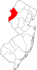
 Map of Lopatcong Township in Warren County. Inset: Location of Warren County highlighted in the State of New Jersey. | |
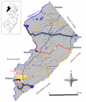
 Census Bureau map of Lopatcong Township, New Jersey | |
| Coordinates: 40°42′52″N 75°09′21″W / 40.714352°N 75.155769°WCoordinates: 40°42′52″N 75°09′21″W / 40.714352°N 75.155769°W[1][2] | |
| Country |
|
| State |
|
| County | Warren |
| Incorporated | March 7, 1851 |
| Government[3] | |
| • Type | Faulkner Act (Small Municipality) |
| • Body | Township Council |
| • Mayor | Thomas McKay (R, term ends December 31, 2017)[4][5] |
| • Administrator / Clerk | M. Beth Dilts[6] |
| Area[1] | |
| • Total | 7.159 sq mi (18.541 km2) |
| • Land | 7.098 sq mi (18.384 km2) |
| • Water | 0.061 sq mi (0.157 km2) 0.85% |
| Area rank |
242nd of 566 in state 16th of 22 in county[1] |
| Elevation[7] | 384 ft (117 m) |
| Population (2010 Census)[8][9][10] | |
| • Total | 8,014 |
| • Estimate (2015)[11] | 8,245 |
| • Rank |
287th of 566 in state 3rd of 22 in county[12] |
| • Density | 1,129.0/sq mi (435.9/km2) |
| • Density rank |
365th of 566 in state 6th of 22 in county[12] |
| Time zone | Eastern (EST) (UTC-5) |
| • Summer (DST) | Eastern (EDT) (UTC-4) |
| ZIP code | 08865[13] |
| Area code(s) | 908[14] |
| FIPS code | 3404141490[1][15][16] |
| GNIS feature ID | 0882252[1][17] |
| Website |
www |
Lopatcong Township /loʊˈpætkɒŋ/ is a township in Warren County, New Jersey, United States. As of the 2010 United States Census, the township's population was 8,014,[8][9][10] reflecting an increase of 2,249 (+39.0%) from the 5,765 counted in the 2000 Census, which had in turn increased by 713 (+14.1%) from the 5,052 counted in the 1990 Census.[18] The township is part of the eastern region of the Lehigh Valley.
Lopatcong Township was featured in a 2003 article in The New York Times which discussed problems of public school financing in suburban communities and various strategies that Lopatcong and other such communities have adopted to deal with the problem.[19]
History
What is now Lopatcong Township was created as Phillipsburg Township on March 7, 1851, by an act approved by the New Jersey Legislature from portions of Greenwich Township and Harmony Township. After Phillipsburg was incorporated as an independent municipality on March 8, 1861, the township changed its name to Lopatcong as of March 18, 1863, after a creek in the area.[20][21]
The name of the creek and township — Lopatcong — came from four words of the Lenni Lenape Native Americans — Lowan peek achtu onk, which meant "winter watering place for deer".[22][23]
Geography
According to the United States Census Bureau, the township had a total area of 7.159 square miles (18.541 km2), including 7.098 square miles (18.384 km2) of land and 0.061 square miles (0.157 km2) of water (0.85%).[1][2]
Delaware Park (2010 Census population of 700[24]) and Lopatcong Overlook (population 734 as of 2010[25]) are unincorporated communities and census-designated places (CDPs) located within the township.[26][27][28]
Other unincorporated communities, localities and place names located partially or completely within the township include Ingersol Heights and Union Town.[29]
Lopatcong is made up of several neighborhoods, including Morris Park, Delaware Park, Rosehill Heights, Brakeley Park, Lows Hollow, Country Hills, Meadow View, Scott's Mountain and Overlook.
Demographics
| Historical population | |||
|---|---|---|---|
| Census | Pop. | %± | |
| 1860 | 3,741 | — | |
| 1870 | 1,150 | * | −69.3% |
| 1880 | 1,591 | 38.3% | |
| 1890 | 1,738 | 9.2% | |
| 1900 | 1,982 | 14.0% | |
| 1910 | 766 | −61.4% | |
| 1920 | 1,050 | 37.1% | |
| 1930 | 1,269 | 20.9% | |
| 1940 | 1,450 | 14.3% | |
| 1950 | 1,737 | 19.8% | |
| 1960 | 2,703 | 55.6% | |
| 1970 | 3,144 | 16.3% | |
| 1980 | 4,998 | 59.0% | |
| 1990 | 5,052 | 1.1% | |
| 2000 | 5,765 | 14.1% | |
| 2010 | 8,014 | 39.0% | |
| Est. 2015 | 8,245 | [11][30] | 2.9% |
| Population sources: 1860-1920[31] 1860-1870[32] 1880-1890[33] 1890-1910[34] 1910-1930[35] 1930-1990[36] 2000[37][38] 2010[8][9][10] * = Lost territory in previous decade[20] | |||
The Township's economic data (as is all of Warren County) is calculated by the US Census Bureau as part of the Allentown-Bethlehem-Easton, PA-NJ Metropolitan Statistical Area.
Census 2010
The 2010 United States Census counted 8,014 people, 3,136 households, and 2,089 families residing in the township. The population density was 1,129.0 per square mile (435.9/km2). The township contained 3,420 housing units at an average density of 481.8 per square mile (186.0/km2). The racial makeup of the township was 87.22% (6,990) White, 6.03% (483) Black or African American, 0.14% (11) Native American, 4.18% (335) Asian, 0.01% (1) Pacific Islander, 0.81% (65) from other races, and 1.61% (129) from two or more races. Hispanics or Latinos of any race were 5.99% (480) of the population.[8]
Out of a total of 3,136 households, 30.0% had children under the age of 18 living with them, 55.7% were married couples living together, 7.9% had a female householder with no husband present, and 33.4% were non-families. 29.3% of all households were made up of individuals, and 13.3% had someone living alone who was 65 years of age or older. The average household size was 2.46 and the average family size was 3.09.[8]
In the township, 23.1% of the population were under the age of 18, 5.5% from 18 to 24, 25.5% from 25 to 44, 27.8% from 45 to 64, and 18.1% who were 65 years of age or older. The median age was 42.3 years. For every 100 females the census counted 88.3 males, but for 100 females at least 18 years old, it was 82.6 males.[8]
The Census Bureau's 2006-2010 American Community Survey showed that (in 2010 inflation-adjusted dollars) median household income was $77,320 (with a margin of error of +/- $4,889) and the median family income was $89,317 (+/- $6,056). Males had a median income of $61,771 (+/- $6,980) versus $49,338 (+/- $4,584) for females. The per capita income for the borough was $33,633 (+/- $2,586). About 0.7% of families and 4.3% of the population were below the poverty line, including 2.0% of those under age 18 and 8.4% of those age 65 or over.[39]
Census 2000
As of the 2000 United States Census[15] there were 5,765 people, 2,143 households, and 1,523 families residing in the township. The population density was 814.6 people per square mile (314.4/km²). There were 2,429 housing units at an average density of 343.2 per square mile (132.5/km²). The racial makeup of the township was 96.27% White, 1.13% African American, 0.07% Native American, 1.63% Asian, 0.49% from other races, and 0.42% from two or more races. Hispanic or Latino of any race were 1.99% of the population.[37][38]
There were 2,143 households out of which 32.3% had children under the age of 18 living with them, 62.5% were married couples living together, 5.7% had a female householder with no husband present, and 28.9% were non-families. 26.2% of all households were made up of individuals and 16.6% had someone living alone who was 65 years of age or older. The average household size was 2.55 and the average family size was 3.09.[37][38]
In the township the population was spread out with 24.5% under the age of 18, 4.4% from 18 to 24, 26.7% from 25 to 44, 22.2% from 45 to 64, and 22.2% who were 65 years of age or older. The median age was 41 years. For every 100 females there were 85.4 males. For every 100 females age 18 and over, there were 79.3 males.[37][38]
The median income for a household in the township was $50,918, and the median income for a family was $65,545. Males had a median income of $52,540 versus $30,967 for females. The per capita income for the township was $24,333. About 4.7% of families and 6.4% of the population were below the poverty line, including 8.2% of those under age 18 and 9.3% of those age 65 or over.[37][38]
Government
Local government
Lopatcong Township is governed by the Faulkner Act (Small Municipality) form of government, which is available under the terms of the Faulkner Act only for those municipalities with a population below 12,000. The government consists of a Mayor and a four-member Township Council, with all positions elected at-large on a partisan basis as part of the November general election. A Mayor is elected directly by the voters to a three-year term of office. Council members are elected at large to serve a term of three years on a staggered basis, so that two seats come up for election each year that the mayor is not up for election.[3]
As of 2016, the Lopatcong Township Council consists of Mayor Thomas McKay (R, term ends December 31, 2017), Council President Joseph B. Pryor (R, 2018), Louis Belcaro (R, 2018), Maureen McCabe (D, 2016) and Yvonne Reitemeyer (R, 2016; appointed to serve an unexpired term).[4][40][41][42][43][44]
In June 2016, the Township Council unanimously selected Yvonne Reitemeyer from a list of three candidates nominated by the Republican municipal committee to fill the seat expiring in December 2016 that became vacant following the resignation of Donna Schneider.[45][46]
In the November 2012 general election, Lori Ciesla, who ran as part of the independent slate of Responsible Lopatcong Leadership, won election, as did Maureen McCabe who won an unexpired one-year term when she defeated Republican incumbent Andrew Horun who had been appointed earlier in the year to fill the vacant seat of H. Matthew Curry.[47]
Federal, state and county representation
Lopatcong Township is located in the 7th Congressional District[48] and is part of New Jersey's 23rd state legislative district.[9][49][50] Prior to the 2010 Census, Lopatcong Township had been part of the 5th Congressional District, a change made by the New Jersey Redistricting Commission that took effect in January 2013, based on the results of the November 2012 general elections.[51]
New Jersey's Seventh Congressional District is represented by Leonard Lance (R, Clinton Township).[52] New Jersey is represented in the United States Senate by Cory Booker (D, Newark, term ends 2021)[53] and Bob Menendez (D, Paramus, 2019).[54][55]
For the 2016–2017 session (Senate, General Assembly), the 23rd Legislative District of the New Jersey Legislature is represented in the State Senate by Michael J. Doherty (R, Washington Township, Warren County) and in the General Assembly by John DiMaio (R, Hackettstown) and Erik Peterson (R, Franklin Township, Hunterdon County).[56] The Governor of New Jersey is Chris Christie (R, Mendham Township).[57] The Lieutenant Governor of New Jersey is Kim Guadagno (R, Monmouth Beach).[58]
Warren County is governed by a Board of Chosen Freeholders whose three members are chosen at-large on a staggered basis in partisan elections with one seat coming up for election each year as part of the November general election. At an annual reorganization meeting held in the beginning of January, the board selects one of its members to serve as Freeholder Director and other as Deputy Director. As of 2014, Warren County's Freeholders are Freeholder Director Edward J. Smith (R, Asbury / Franklin Township, 2015), Freeholder Deputy Director Richard D. Gardner (R, Asbury / Franklin Township, 2014) and Freeholder Jason Sarnoski (R, Lopatcong Township, 2016).[59] Constitutional officers elected on a countywide basis are County Clerk Patricia J. Kolb (Blairstown Township),[60] Sheriff David Gallant (Blairstown Township) and Surrogate Kevin O'Neill (Hackettstown).[61][62] The County Administrator, Steve Marvin, is responsible for overseeing the day-to-day operation of the county and its departments.[63]
Politics
As of March 23, 2011, there were a total of 5,153 registered voters in Lopatcong Township, of which 1,391 (27.0% vs. 21.5% countywide) were registered as Democrats, 1,470 (28.5% vs. 35.3%) were registered as Republicans and 2,288 (44.4% vs. 43.1%) were registered as Unaffiliated. There were 4 voters registered to other parties.[64] Among the township's 2010 Census population, 64.3% (vs. 62.3% in Warren County) were registered to vote, including 83.6% of those ages 18 and over (vs. 81.5% countywide).[64][65]
In the 2012 presidential election, Republican Mitt Romney received 1,964 votes (52.8% vs. 56.0% countywide), ahead of Democrat Barack Obama with 1,638 votes (44.0% vs. 40.8%) and other candidates with 51 votes (1.4% vs. 1.7%), among the 3,720 ballots cast by the township's 5,386 registered voters, for a turnout of 69.1% (vs. 66.7% in Warren County).[66][67] In the 2008 presidential election, Republican John McCain received 1,985 votes (51.9% vs. 55.2% countywide), ahead of Democrat Barack Obama with 1,730 votes (45.2% vs. 41.4%) and other candidates with 46 votes (1.2% vs. 1.6%), among the 3,827 ballots cast by the township's 5,090 registered voters, for a turnout of 75.2% (vs. 73.4% in Warren County).[68] In the 2004 presidential election, Republican George W. Bush received 1,994 votes (57.5% vs. 61.0% countywide), ahead of Democrat John Kerry with 1,419 votes (40.9% vs. 37.2%) and other candidates with 30 votes (0.9% vs. 1.3%), among the 3,467 ballots cast by the township's 4,536 registered voters, for a turnout of 76.4% (vs. 76.3% in the whole county).[69]
In the 2013 gubernatorial election, Republican Chris Christie received 70.4% of the vote (1,615 cast), ahead of Democrat Barbara Buono with 27.6% (634 votes), and other candidates with 2.0% (45 votes), among the 2,345 ballots cast by the township's 5,506 registered voters (51 ballots were spoiled), for a turnout of 42.6%.[70][71] In the 2009 gubernatorial election, Republican Chris Christie received 1,455 votes (58.6% vs. 61.3% countywide), ahead of Democrat Jon Corzine with 736 votes (29.6% vs. 25.7%), Independent Chris Daggett with 228 votes (9.2% vs. 9.8%) and other candidates with 35 votes (1.4% vs. 1.5%), among the 2,484 ballots cast by the township's 4,981 registered voters, yielding a 49.9% turnout (vs. 49.6% in the county).[72]
Education
The Lopatcong Township School District serves public school students in pre-Kindergarten through eighth grade.[73] As of the 2012-13 school year, the district's two schools had an enrollment of 870 students and 76.0 classroom teachers (on an FTE basis), for a student–teacher ratio of 11.45:1.[74] Schools in the district (with 2010-11 enrollment data from the National Center for Education Statistics[75]) are Lopatcong Elementary School (grades PreK-4, 476 students) and Lopatcong Middle School (5-8, 394 students).[76] Before the Middle School opened in 2003, students would attend the Elementary School through eighth grade; The middle school was constructed in the wake of increasing enrollment, which climbed more than 50% from just over 500 in 1995 to more than 750 by 2001.[19]
Public school students in ninth through twelfth grades attend Phillipsburg High School in Phillipsburg as part of a sending/receiving relationship with the Phillipsburg School District. The high school also serves students from four other sending communities: Alpha, Bloomsbury (in Hunterdon County), Greenwich Township and Pohatcong Township.[73][77][78] The site of the new Phillipsburg High School, which began construction in January 2014, is in Lopatcong's borders. The three-story, 330,000-square-foot (31,000 m2) building, with more than double the floor space of the existing high school, is planned for completion for the 2016-17 school year.[79]
Students from the township and from all of Warren County are eligible to attend Ridge and Valley Charter School in Frelinghuysen Township (for grades K-8)[80] or Warren County Technical School in Washington borough (for 9-12),[81] with special education services provided by local districts supplemented throughout the county by the Warren County Special Services School District in Oxford Township (for PreK-12).[73][82]
Transportation
Roads and highways
As of May 2010, the township had a total of 45.59 miles (73.37 km) of roadways, of which 35.19 miles (56.63 km) were maintained by the municipality, 6.56 miles (10.56 km) by Warren County and 3.84 miles (6.18 km) by the New Jersey Department of Transportation.[83]
The main county road that passes through is County Route 519 which passes through in the eastern part. Route 57 traverses towards the center and has its western end at US 22 which also passes through in the southern section of the township.
Public transportation
New Jersey Transit bus service is provided on the 890 and 891 routes.[84]
Notable people
People who were born in, residents of, or otherwise closely associated with Lopatcong Township include:
- Ned Bolcar (born 1967), linebacker who played three seasons in the NFL, one with the Seattle Seahawks and two with the Miami Dolphins.[85]
Film community
Lopatcong Township was the primary location for the independent film Several Ways to Die Trying. The film's writer/director, Glen Tickle, as well as members of the cast and crew are residents of the township.[86]
References
- 1 2 3 4 5 6 2010 Census Gazetteer Files: New Jersey County Subdivisions, United States Census Bureau. Accessed May 21, 2015.
- 1 2 US Gazetteer files: 2010, 2000, and 1990, United States Census Bureau. Accessed September 4, 2014.
- 1 2 2012 New Jersey Legislative District Data Book, Rutgers University Edward J. Bloustein School of Planning and Public Policy, March 2013, p. 103.
- 1 2 Town Council, Lopatcong Township. Accessed August 8, 2016.
- ↑ 2016 New Jersey Mayors Directory, New Jersey Department of Community Affairs. Accessed June 14, 2016.
- ↑ Municipal Clerk/Administrator, Lopatcong Township. Accessed August 8, 2016.
- ↑ U.S. Geological Survey Geographic Names Information System: Township of Lopatcong, Geographic Names Information System. Accessed March 7, 2013.
- 1 2 3 4 5 6 DP-1 - Profile of General Population and Housing Characteristics: 2010 for Lopatcong township, Warren County, New Jersey, United States Census Bureau. Accessed September 21, 2012.
- 1 2 3 4 Municipalities Grouped by 2011-2020 Legislative Districts, New Jersey Department of State, p. 10. Accessed January 6, 2013.
- 1 2 3 Profile of General Demographic Characteristics: 2010 for Lopatcong township, New Jersey Department of Labor and Workforce Development. Accessed September 21, 2012.
- 1 2 PEPANNRES - Annual Estimates of the Resident Population: April 1, 2010 to July 1, 2015 - 2015 Population Estimates for New Jersey municipalities, United States Census Bureau. Accessed May 22, 2016.
- 1 2 GCT-PH1 Population, Housing Units, Area, and Density: 2010 - State -- County Subdivision from the 2010 Census Summary File 1 for New Jersey, United States Census Bureau. Accessed September 21, 2012.
- ↑ Look Up a ZIP Code for Lopatcong, NJ, United States Postal Service. Accessed September 21, 2012.
- ↑ Area Code Lookup - NPA NXX for Lopatcong, NJ, Area-Codes.com. Accessed September 16, 2013.
- 1 2 American FactFinder, United States Census Bureau. Accessed September 4, 2014.
- ↑ A Cure for the Common Codes: New Jersey, Missouri Census Data Center. Accessed September 21, 2012.
- ↑ US Board on Geographic Names, United States Geological Survey. Accessed September 4, 2014.
- ↑ Table 7. Population for the Counties and Municipalities in New Jersey: 1990, 2000 and 2010, New Jersey Department of Labor and Workforce Development, February 2011. Accessed September 21, 2012.
- 1 2 Mansnerus, Laura. "Great Haven for Families, but Don't Bring Children", The New York Times August 13, 2003. Accessed June 10, 2013. "That describes Lopatcong, near Interstate 78 at the state's western edge. As farms gave way to subdivisions of single-family houses, the population rose to 6,991 in 2002 from 5,765 in 2000. Enrollment at the town's elementary school was 503 in 1995 and 755 in 2001, and it is expected to reach 900 this fall, when a new middle school will open."
- 1 2 Snyder, John P. The Story of New Jersey's Civil Boundaries: 1606-1968, Bureau of Geology and Topography; Trenton, New Jersey; 1969. p. 247. Accessed September 21, 2012.
- ↑ Snell, James P. (1881) History of Sussex and Warren Counties, New Jersey, With Illustrations and Biographical Sketches of its Prominent Men and Pioneers. (Centennial ed., Harmony, NJ: Harmony Press, 1981) p.682
- ↑ Poncavage, Joanna. "Lenape language Legacy; In towns, creeks and more, Indian nation left its mark on our region", The Morning Call, November 14, 2008. Accessed September 21, 2012. "LOPATCONG - From Lenape words: Lowan peek achtu onk Meaning: Winter water place for deer"
- ↑ Hutchinson, Viola L. The Origin of New Jersey Place Names, New Jersey Public Library Commission, May 1945. Accessed September 3, 2015.
- ↑ DP-1 - Profile of General Population and Housing Characteristics: 2010 Demographic Profile Data for Delaware Park CDP, New Jersey, United States Census Bureau. Accessed September 20, 2012.
- ↑ DP-1 - Profile of General Population and Housing Characteristics: 2010 Demographic Profile Data for Lopatcong Overlook CDP, New Jersey, United States Census Bureau. Accessed September 20, 2012.
- ↑ GCT-PH1 - Population, Housing Units, Area, and Density: 2010 - County -- County Subdivision and Place from the 2010 Census Summary File 1 for Warren County, New Jersey, United States Census Bureau. Accessed June 6, 2013.
- ↑ 2006-2010 American Community Survey Geography for New Jersey, United States Census Bureau. Accessed June 6, 2013.
- ↑ New Jersey: 2010 - Population and Housing Unit Counts - 2010 Census of Population and Housing (CPH-2-32), United States Census Bureau, p. III-5, August 2012. Accessed June 6, 2013.
- ↑ Locality Search, State of New Jersey. Accessed April 3, 2015.
- ↑ Census Estimates for New Jersey April 1, 2010 to July 1, 2015, United States Census Bureau. Accessed May 22, 2016.
- ↑ Compendium of censuses 1726-1905: together with the tabulated returns of 1905, New Jersey Department of State, 1906. Accessed June 6, 2013.
- ↑ Raum, John O. The History of New Jersey: From Its Earliest Settlement to the Present Time, Volume 1, p. 272, J. E. Potter and company, 1877. Accessed June 6, 2013. "Lopatcong contains 1,150 inhabitants [in 1870].... Phillipsburg is on the Delaware directly opposite in Pennsylvania The city of the same name is divided into three wards The population in 1860 was 3,741; and in 1870, 5,932." Note that the 1860 population listed for Phillipsburg city is actually the data for Phillipsburg township, before it was renamed as Lopatcong.
- ↑ Porter, Robert Percival. Preliminary Results as Contained in the Eleventh Census Bulletins: Volume III - 51 to 75, p. 100. United States Census Bureau, 1890. Accessed June 6, 2013.
- ↑ Thirteenth Census of the United States, 1910: Population by Counties and Minor Civil Divisions, 1910, 1900, 1890, United States Census Bureau, p. 339. Accessed June 6, 2013.
- ↑ Fifteenth Census of the United States : 1930 - Population Volume I, United States Census Bureau, p. 719. Accessed June 6, 2013.
- ↑ Table 6. New Jersey Resident Population by Municipality: 1930 - 1990, New Jersey Department of Labor and Workforce Development. Accessed June 28, 2015.
- 1 2 3 4 5 Census 2000 Profiles of Demographic / Social / Economic / Housing Characteristics for Lopatcong township, Warren County, New Jersey, United States Census Bureau. Accessed September 21, 2012.
- 1 2 3 4 5 DP-1: Profile of General Demographic Characteristics: 2000 - Census 2000 Summary File 1 (SF 1) 100-Percent Data for Lopatcong township, Warren County, New Jersey, United States Census Bureau. Accessed September 21, 2012.
- ↑ DP03: Selected Economic Characteristics from the 2006-2010 American Community Survey 5-Year Estimates for Lopatcong township, Warren County, New Jersey, United States Census Bureau. Accessed September 21, 2012.
- ↑ 2016 Municipal Data Sheet, Lopatcong Township. Accessed August 8, 2016. As of date accessed, Belcaro is listed with an incorrect term-end year of 2017.
- ↑ 2015 Official Directory Warren County, New Jersey, Warren County, New Jersey. Accessed August 7, 2016.
- ↑ General Election November 3, 2015 Warren County Official Tally, Warren County, New Jersey, updated November 6, 2015. Accessed August 7, 2016.
- ↑ General Election November 4, 2014 Warren County Official Tally, Warren County, New Jersey, updated November 10, 2014. Accessed August 7, 2016.
- ↑ General Election November 5, 2013 Warren County Official Tally, Warren County, New Jersey, updated November 19, 2013. Accessed August 7, 2016.
- ↑ Novak, Steve. "Meet Lopatcong Township's newest councilwoman", The Express-Times, June 28, 2016. Accessed August 8, 2016. "Lopatcong Township has a new councilwoman, though only for the next six months. Yvonne Reitemeyer, 46, was unanimously selected by the council Monday night to fill the rest of the term left by Councilwoman Donna Schneider's resignation this month."
- ↑ Special Meeting Minutes June 27, 2016, Township of Lopatcong. Accessed August 8, 2016. "Council Vacancy: - Council President Pryor made a motion to appoint Yvonne Reitemeyer to fill the Council vacancy, seconded by Councilman Belcaro. Roll call vote: AYES: Councilman Belcaro, Councilwoman McCabe, Council President Pryor, Mayor McKay; NAYS: None. Yvonne Reitemeyer was sworn in as Councilwoman."
- ↑ Foster, David. "Independents take two seats, Republican one on Lopatcong Township Council, according to unofficial results", The Express-Times, November 7, 2012. Accessed June 10, 2013. "Independent candidate Lori Ciesla secured a nod for the three-year seat along with Republican Louis Belcaro.... Independent Maureen McCabe squeaked out a win by four votes over incumbent Andrew Horun for the one-year term. Horun was appointed by council in April to fill a vacancy left by H. Matthew Curry."
- ↑ Plan Components Report, New Jersey Redistricting Commission, December 23, 2011. Accessed January 6, 2013.
- ↑ 2016 New Jersey Citizen's Guide to Government, p. 60, New Jersey League of Women Voters. Accessed July 20, 2016.
- ↑ Districts by Number for 2011-2020, New Jersey Legislature. Accessed January 6, 2013.
- ↑ 2011 New Jersey Citizen's Guide to Government, p. 60, New Jersey League of Women Voters. Accessed May 22, 2015.
- ↑ Directory of Representatives: New Jersey, United States House of Representatives. Accessed January 5, 2012.
- ↑ About Cory Booker, United States Senate. Accessed January 26, 2015. "He now owns a home and lives in Newark's Central Ward community."
- ↑ Biography of Bob Menendez, United States Senate, January 26, 2015. "He currently lives in Paramus and has two children, Alicia and Robert."
- ↑ Senators of the 114th Congress from New Jersey. United States Senate. Accessed January 26, 2015. "Booker, Cory A. - (D - NJ) Class II; Menendez, Robert - (D - NJ) Class I"
- ↑ Legislative Roster 2016-2017 Session, New Jersey Legislature. Accessed January 17, 2016.
- ↑ "About the Governor". State of New Jersey. Retrieved 2010-01-21.
- ↑ "About the Lieutenant Governor". State of New Jersey. Retrieved 2010-01-21.
- ↑ Board of Chosen Freeholders, Warren County, New Jersey. Accessed September 15, 2014.
- ↑ County Clerk's Office, Warren County, New Jersey. Accessed September 15, 2014.
- ↑ Message from Surrogate, Warren County, New Jersey. Accessed September 15, 2014.
- ↑ Constitutional Officers, Warren County, New Jersey. Accessed September 15, 2014.
- ↑ 2013 Official Directory, Warren County, New Jersey. Accessed September 15, 2014.
- 1 2 Voter Registration Summary - Warren, New Jersey Department of State Division of Elections, March 23, 2011. Accessed June 8, 2013.
- ↑ GCT-P7: Selected Age Groups: 2010 - State -- County Subdivision; 2010 Census Summary File 1 for New Jersey, United States Census Bureau. Accessed June 8, 2013.
- ↑ Presidential November 6, 2012 General Election Results - Warren County, New Jersey Department of State Division of Elections, March 15, 2013. Accessed June 8, 2013.
- ↑ Number of Registered Voters and Ballots Cast November 6, 2012 General Election Results - Warren County, New Jersey Department of State Division of Elections, March 15, 2013. Accessed June 8, 2013.
- ↑ 2008 Presidential General Election Results: Warren County, New Jersey Department of State Division of Elections, December 23, 2008. Accessed June 8, 2013.
- ↑ 2004 Presidential Election: Warren County, New Jersey Department of State Division of Elections, December 13, 2004. Accessed June 8, 2013.
- ↑ "Governor - Warren County" (PDF). New Jersey Department of Elections. January 29, 2014. Retrieved December 24, 2014.
- ↑ "Number of Registered Voters and Ballots Cast - November 5, 2013 - General Election Results - Warren County" (PDF). New Jersey Department of Elections. January 29, 2014. Retrieved December 24, 2014.
- ↑ 2009 Governor: Warren County, New Jersey Department of State Division of Elections, December 31, 2009. Accessed June 8, 2013.
- 1 2 3 Municipal Guide to Public School Districts, Warren County, New Jersey. Accessed March 7, 2015.
- ↑ District information for Lopatcong Township School District, National Center for Education Statistics. Accessed March 7, 2015.
- ↑ School Data for the Lopatcong Township School District, National Center for Education Statistics. Accessed March 7, 2015.
- ↑ New Jersey School Directory for the Lopatcong Township School District, New Jersey Department of Education. Accessed March 7, 2015.
- ↑ Phillipsburg High School 2015 Report Card Narrative, New Jersey Department of Education. Accessed June 1, 2016. "At the secondary level, the district serves not only students from the town of Phillipsburg which makes up 37.6% of the high school population, but also students from the surrounding boroughs of Alpha and Bloomsbury, as well as the townships of Greenwich, Lopatcong, and Pohatcong."
- ↑ About PSD, Phillipsburg School District. Accessed June 1, 2016. "The district serves students from the Town of Phillipsburg and five sending communities at the secondary level: Alpha, Bloomsbury, Greenwich, Lopatcong and Pohatcong Townships."
- ↑ Peters, Sarah. "New Phillipsburg High School beginning to take shape in Lopatcong Township", The Express-Times, July 7, 2014. Accessed March 7, 2015. "The new Phillipsburg High School is starting to take shape atop a steep hillside off Belvidere Road in Lopatcong Township.... Five school board members and at least four administrators embarked on the tour of the property scheduled to open during the 2016-2017 academic year."
- ↑ Overview, Ridge and Valley Charter School. Accessed September 16, 2013. "Enrollment is open to any child in New Jersey, with preference for students from the districts of Blairstown, Frelinghuysen, Hardwick, Knowlton and North Warren Regional."
- ↑ About Us, Warren County Technical School. Accessed September 16, 2013.
- ↑ About, Warren County Special Services School District. Accessed September 16, 2013.
- ↑ Warren County Mileage by Municipality and Jurisdiction, New Jersey Department of Transportation, May 2010. Accessed July 18, 2014.
- ↑ Warren County Bus/Rail Connections, New Jersey Transit, backed up by the Internet Archive as of July 26, 2010. Accessed September 21, 2012.
- ↑ Staff. "Warren County Hall of Fame inductees announced", Warren Reporter, August 22, 2014. Accessed May 2, 2015. "A native of Lopatcong Township and a Phillipsburg High School graduate, Bolcar was a 1984 USA Today High School All-American selection."
- ↑ Longsdorf, Amy. "Celebrating Lehigh Valley filmmakers2nd annual festival gives a big screen to locally produced works, including features, shorts, web series", The Morning Call, October 26, 2012. Accessed June 10, 2013.
External links
- Lopatcong Township website
- Warren County page for Lopatcong Township
- Lopatcong Township School District
- Lopatcong Township School District's 2014–15 School Report Card from the New Jersey Department of Education
- School Data for the Lopatcong Township School District, National Center for Education Statistics
- Phillipsburg High School