Wantage Township, New Jersey
| Wantage Township, New Jersey | |
|---|---|
| Township | |
| Township of Wantage | |
|
| |
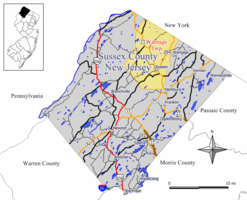 Map of Wantage Township in Sussex County. Inset: Location of Sussex County highlighted in the State of New Jersey. | |
 Census Bureau map of Wantage Township, New Jersey. | |
| Coordinates: 41°15′08″N 74°37′58″W / 41.252181°N 74.632827°WCoordinates: 41°15′08″N 74°37′58″W / 41.252181°N 74.632827°W[1][2] | |
| Country |
|
| State |
|
| County | Sussex |
| Formed | May 30, 1754 (as precinct) |
| Incorporated | February 21, 1798 |
| Named for | Wantage, England |
| Government[3] | |
| • Type | Township |
| • Body | Township Committee |
| • Mayor | Ronald Bassani (R, term ends December 31, 2016)[4][5] |
| • Administrator / Clerk | James Doherty[4] |
| Area[1] | |
| • Total | 67.481 sq mi (174.776 km2) |
| • Land | 66.753 sq mi (172.890 km2) |
| • Water | 0.728 sq mi (1.886 km2) 1.08% |
| Area rank |
18th of 566 in state 2nd of 24 in county[1] |
| Elevation[6] | 538 ft (164 m) |
| Population (2010 Census)[7][8][9] | |
| • Total | 11,358 |
| • Estimate (2015)[10] | 11,074 |
| • Rank |
215th of 566 in state 4th of 24 in county[11] |
| • Density | 170.1/sq mi (65.7/km2) |
| • Density rank |
518th of 566 in state 18th of 24 in county[11] |
| Time zone | Eastern (EST) (UTC-5) |
| • Summer (DST) | Eastern (EDT) (UTC-4) |
| ZIP code | 07461[12] |
| Area code(s) | 973[13] |
| FIPS code | 3403776790[1][14][15] |
| GNIS feature ID | 0882257[1][16] |
| Website |
www |
Wantage Township is a township in Sussex County, New Jersey, United States. As of the 2010 United States Census, the township's population was 11,358,[7][8][9] reflecting an increase of 971 (+9.3%) from the 10,387 counted in the 2000 Census, which had in turn increased by 900 (+9.5%) from the 9,487 counted in the 1990 Census.[17]
Wantage Township was formed as a precinct on May 30, 1754, from portions of Newton Township. It was incorporated as a Township on February 21, 1798, as part of the state's initial group of 104 townships. Boundary exchanges were made with Frankford Township in both 1826 and 1834. Portions of the township were taken on October 14, 1891, to form the Borough of Deckertown (which was renamed to Sussex borough in 1902).[18] The township was named for Wantage, England.[19]
Geography
According to the United States Census Bureau, the township had a total area of 67.481 square miles (174.776 km2), including 66.753 square miles (172.890 km2) of land and 0.728 square miles (1.886 km2) of water (1.08%).[1][2] The township is located in the Kittatinny Valley which is a section of the Great Appalachian Valley that stretches for 700 miles (1,100 km) from Canada to Alabama.
Unincorporated communities, localities and place names located partially or completely within the township include Beemerville, Colesville, Hanford, Lake Neepaulin, Lake Rutherford, Lewisburg, Libertyville, Martins, Mount Salem, Papakating, Plumbsock, Quarryville, Rockport, Roys and Woodbourne.[20]
Rutan Hill, also called Volcanic Hill, located near the Beemerville section of Wantage Township, is New Jersey's only volcanic site that was last active over 440 million years ago.[21]
Rivers and streams in Wantage are tributaries in the Wallkill River watershed, and include:
- Papakating Creek
- West Branch Papakating Creek
- Neepaulakating Creek, dammed to create Lake Neepaulin.
- Clove Brook, dammed to create Clove Acres Lake
The township completely surrounds Sussex borough and borders the municipalities of Frankford Township, Hardyston Township, Lafayette Township, Montague Township, Sandyston Township and Vernon Township in Sussex County; and both Greenville and Minisink in Orange County, New York.
Demographics
| Historical population | |||
|---|---|---|---|
| Census | Pop. | %± | |
| 1810 | 2,969 | — | |
| 1820 | 3,307 | 11.4% | |
| 1830 | 4,034 | 22.0% | |
| 1840 | 3,908 | −3.1% | |
| 1850 | 3,934 | 0.7% | |
| 1860 | 3,862 | −1.8% | |
| 1870 | 3,636 | −5.9% | |
| 1880 | 3,361 | −7.6% | |
| 1890 | 3,412 | 1.5% | |
| 1900 | 2,217 | * | −35.0% |
| 1910 | 2,077 | −6.3% | |
| 1920 | 1,898 | −8.6% | |
| 1930 | 2,075 | 9.3% | |
| 1940 | 2,376 | 14.5% | |
| 1950 | 2,543 | 7.0% | |
| 1960 | 3,308 | 30.1% | |
| 1970 | 4,329 | 30.9% | |
| 1980 | 7,268 | 67.9% | |
| 1990 | 9,487 | 30.5% | |
| 2000 | 10,387 | 9.5% | |
| 2010 | 11,358 | 9.3% | |
| Est. 2015 | 11,074 | [10][22] | −2.5% |
| Population sources: 1810-1920[23] 1840[24] 1850-1870[25] 1850[26] 1870[27] 1880-1890[28] 1890-1910[29] 1910-1930[30] 1930-1990[31] 2000[32][33] 2010[7][8][9] * = Lost territory in previous decade.[18] | |||
Census 2010
The 2010 United States Census counted 11,358 people, 3,910 households, and 3,116 families residing in the township. The population density was 170.1 per square mile (65.7/km2). The township contained 4,173 housing units at an average density of 62.5 per square mile (24.1/km2). The racial makeup of the township was 95.23% (10,816) White, 1.21% (137) Black or African American, 0.11% (13) Native American, 0.99% (113) Asian, 0.00% (0) Pacific Islander, 0.93% (106) from other races, and 1.52% (173) from two or more races. Hispanics or Latinos of any race were 5.23% (594) of the population.[7]
Out of a total of 3,910 households, 34.7% had children under the age of 18 living with them, 66.8% were married couples living together, 8.5% had a female householder with no husband present, and 20.3% were non-families. 15.8% of all households were made up of individuals, and 6.4% had someone living alone who was 65 years of age or older. The average household size was 2.90 and the average family size was 3.25.[7]
In the township, 25.0% of the population were under the age of 18, 8.5% from 18 to 24, 22.5% from 25 to 44, 32.2% from 45 to 64, and 11.8% who were 65 years of age or older. The median age was 41.2 years. For every 100 females the census counted 98.6 males, but for 100 females at least 18 years old, it was 96.7 males.[7]
The Census Bureau's 2006-2010 American Community Survey showed that (in 2010 inflation-adjusted dollars) median household income was $72,270 (with a margin of error of +/− $7,478) and the median family income was $78,934 (+/− $9,462). Males had a median income of $55,509 (+/− $8,605) versus $41,013 (+/− $3,999) for females. The per capita income for the borough was $29,266 (+/− $2,047). About 4.3% of families and 3.5% of the population were below the poverty line, including 4.0% of those under age 18 and 5.3% of those age 65 or over.[34]
Census 2000
As of the 2000 United States Census[14] there were 10,387 people, 3,441 households, and 2,856 families residing in the township. The population density was 154.8 people per square mile (59.8/km2). There were 3,663 housing units at an average density of 54.6 per square mile (21.1/km2). The racial makeup of the township was 97.10% White, 0.65% African American, 0.06% Native American, 0.67% Asian, 0.01% Pacific Islander, 0.41% from other races, and 1.10% from two or more races. Hispanic or Latino of any race were 2.89% of the population.[32][33]
There were 3,441 households out of which 43.6% had children under the age of 18 living with them, 71.5% were married couples living together, 8.0% had a female householder with no husband present, and 17.0% were non-families. 13.6% of all households were made up of individuals and 5.0% had someone living alone who was 65 years of age or older. The average household size was 3.02 and the average family size was 3.33.[32][33]
In the township the population was spread out with 29.4% under the age of 18, 7.1% from 18 to 24, 30.0% from 25 to 44, 24.8% from 45 to 64, and 8.8% who were 65 years of age or older. The median age was 36 years. For every 100 females there were 96.9 males. For every 100 females age 18 and over, there were 96.0 males.[32][33]
The median income for a household in the township was $58,440, and the median income for a family was $65,339. Males had a median income of $42,697 versus $30,160 for females. The per capita income for the township was $22,488. About 4.2% of families and 4.9% of the population were below the poverty line, including 5.7% of those under age 18 and 5.2% of those age 65 or over.[32][33]
Government
Local government
Wantage Township is governed under the Township form of government. The governing body is a three-member Township Committee, whose members are elected directly by the voters at-large in partisan elections to serve three-year terms of office on a staggered basis, with one seat coming up for election each year as part of the November general election in a three-year cycle.[3][35] At an annual reorganization meeting, the Township Committee selects one of its members to serve as Mayor and another as Deputy Mayor.
As of 2016, members of the Wantage Township Committee are Mayor Ronald Bassani (R, term on committee and as mayor ends December 31, 2016), Deputy Mayor Jon Morris (R, term on committee ends 2017; term as deputy mayor ends 2016) and William Gaechter (R, 2018).[4][36][37][38][39]
Federal, state and county representation
Wantage Township is located in the 5th Congressional District[40] and is part of New Jersey's 24th state legislative district.[8][41][42]
New Jersey's Fifth Congressional District is represented by Scott Garrett (R, Wantage Township).[43] New Jersey is represented in the United States Senate by Cory Booker (D, Newark, term ends 2021)[44] and Bob Menendez (D, Paramus, 2019).[45][46]
For the 2016–2017 session (Senate, General Assembly), the 24th Legislative District of the New Jersey Legislature is represented in the State Senate by Steve Oroho (R, Franklin) and in the General Assembly by Parker Space (R, Wantage Township) and Gail Phoebus (R, Andover Township).[47] The Governor of New Jersey is Chris Christie (R, Mendham Township).[48] The Lieutenant Governor of New Jersey is Kim Guadagno (R, Monmouth Beach).[49]
Sussex County is governed by a Board of Chosen Freeholders whose five members are elected at-large in partisan elections on a staggered basis, with either one or two seats coming up for election each year. At an annual reorganization meeting held in the beginning of January, the board selects a Freeholder Director and Deputy Director from among its members, with day-to-day supervision of the operation of the county delegated to a County Administrator.[50] As of 2014, Sussex County's Freeholders are Freeholder Director Richard Vohden (R, Green Township, 2016),[51] Deputy Director Dennis J. Mudrick (R, Sparta Township, 2015),[52] Phillip R. Crabb (R, Franklin, 2014),[53] George Graham (R, Stanhope, 2016)[54] and Gail Phoebus (R, Andover Township, 2015).[55][50] Graham was chosen in April 2013 to fill the seat vacated by Parker Space, who had been chosen to fill a vacancy in the New Jersey General Assembly.[56] Constitutional officers elected on a countywide basis are County Clerk Jeff Parrott (R, 2016),[57] Sheriff Michael F. Strada (R, 2016)[58] and Surrogate Gary R. Chiusano (R, filling the vacancy after the resignation of Nancy Fitzgibbons).[59][56] The County Administrator is John Eskilson.[60][61]
Politics
As of March 23, 2011, there were a total of 7,397 registered voters in Wantage Township, of which 969 (13.1% vs. 16.5% countywide) were registered as Democrats, 3,315 (44.8% vs. 39.3%) were registered as Republicans and 3,104 (42.0% vs. 44.1%) were registered as Unaffiliated. There were 9 voters registered to other parties.[62] Among the township's 2010 Census population, 65.1% (vs. 65.8% in Sussex County) were registered to vote, including 86.8% of those ages 18 and over (vs. 86.5% countywide).[62][63]
In the 2012 presidential election, Republican Mitt Romney received 3,269 votes (62.8% vs. 59.4% countywide), ahead of Democrat Barack Obama with 1,800 votes (34.6% vs. 38.2%) and other candidates with 119 votes (2.3% vs. 2.1%), among the 5,203 ballots cast by the township's 7,467 registered voters, for a turnout of 69.7% (vs. 68.3% in Sussex County).[64] In the 2008 presidential election, Republican John McCain received 3,454 votes (62.2% vs. 59.2% countywide), ahead of Democrat Barack Obama with 1,987 votes (35.8% vs. 38.7%) and other candidates with 74 votes (1.3% vs. 1.5%), among the 5,551 ballots cast by the township's 7,319 registered voters, for a turnout of 75.8% (vs. 76.9% in Sussex County).[65] In the 2004 presidential election, Republican George W. Bush received 3,300 votes (67.0% vs. 63.9% countywide), ahead of Democrat John Kerry with 1,564 votes (31.7% vs. 34.4%) and other candidates with 48 votes (1.0% vs. 1.3%), among the 4,928 ballots cast by the township's 6,500 registered voters, for a turnout of 75.8% (vs. 77.7% in the whole county).[66]
In the 2013 gubernatorial election, Republican Chris Christie received 70.0% of the vote (2,107 cast), ahead of Democrat Barbara Buono with 27.0% (812 votes), and other candidates with 3.0% (89 votes), among the 3,038 ballots cast by the township's 7,582 registered voters (30 ballots were spoiled), for a turnout of 40.1%.[67][68] In the 2009 gubernatorial election, Republican Chris Christie received 2,602 votes (63.7% vs. 63.3% countywide), ahead of Democrat Jon Corzine with 999 votes (24.5% vs. 25.7%), Independent Chris Daggett with 388 votes (9.5% vs. 9.1%) and other candidates with 59 votes (1.4% vs. 1.3%), among the 4,084 ballots cast by the township's 7,192 registered voters, yielding a 56.8% turnout (vs. 52.3% in the county).[69]
Education
Public school students in Kindergarten through eighth grade attend the schools of the Sussex-Wantage Regional School District, together with children from Sussex Borough. As of the 2011-12 school year, the district's three schools had an enrollment of 1,362 students and 116.8 classroom teachers (on an FTE basis), for a student–teacher ratio of 11.66:1.[70] The three schools in the district (with 2011-12 enrollment data from the National Center for Education Statistics[71]) are Clifton E. Lawrence School[72] in Wantage (375 students; grades Kindergarten to 2), Wantage Elementary School[73] in Sussex (484; 3 - 5) and Sussex Middle School[74] in Sussex (503; 6 - 8).[75][76]
For ninth through twelfth grades, public school students attend High Point Regional High School, together with students from Branchville, Frankford Township, Lafayette Township, Montague Township, Sussex Borough and Wantage Township (where the school is located).[77][78] As of the 2013-14 school year, the high school had an enrollment of 999 students and 89.8 classroom teachers (on an FTE basis), for a student–teacher ratio of 11.1:1.[79]
Transportation
Roads and highways
As of May 2010, the township had a total of 172.15 miles (277.05 km) of roadways, of which 119.72 miles (192.67 km) were maintained by the municipality, 35.31 miles (56.83 km) by Sussex County and 17.12 miles (27.55 km) by the New Jersey Department of Transportation.[80]
CR 519, CR 565, Route 23 and Route 284 all pass through the township. Route 284 connects to NY 284, providing access to U.S. Route 6.
Aviation
Sussex Airport, a small general aviation airport, is located in Wantage Township.[81]
Wineries
Notable people
People who were born in, residents of, or otherwise closely associated with Wantage Township include:
- Nick Boyle (born 1993), tight end for the Baltimore Ravens.[82]
- Nicholas D'Agostino (born 1989), motivational speaker, author, coach, radio host, nonprofit founder and entrepreneur who was diagnosed with spinal muscular atrophy as a child.[83]
- Lou Dobbs (born 1945), radio and television host.[84]
- Scott Garrett (born 1959), U.S. Representative for New Jersey's 5th congressional district, serving since 2003.[85]
- Hugh Judson Kilpatrick (1836–1881), Union Army officer during the American Civil War, achieving the rank of brevet major general.[86]
- Parker Space (born 1968), politician who has served in the New Jersey General Assembly since February 2013, where he represents the 24th Legislative District, who served as Mayor of Wantage Township in 2005 and 2008-09.[87]
- Harold J. Wirths (born c. 1965), politician appointed by Governor Chris Christie in 2010 to serve as the Commissioner of the New Jersey Department of Labor and Workforce Development.[88]
References
- 1 2 3 4 5 6 2010 Census Gazetteer Files: New Jersey County Subdivisions, United States Census Bureau. Accessed May 21, 2015.
- 1 2 US Gazetteer files: 2010, 2000, and 1990, United States Census Bureau. Accessed September 4, 2014.
- 1 2 2012 New Jersey Legislative District Data Book, Rutgers University Edward J. Bloustein School of Planning and Public Policy, March 2013, p. 110.
- 1 2 3 Mayor & Committee, Wantage Township. Accessed August 3, 2016.
- ↑ 2016 New Jersey Mayors Directory, New Jersey Department of Community Affairs. Accessed June 14, 2016.
- ↑ U.S. Geological Survey Geographic Names Information System: Township of Wantage, Geographic Names Information System. Accessed March 14, 2013.
- 1 2 3 4 5 6 DP-1 - Profile of General Population and Housing Characteristics: 2010 for Wantage township, Sussex County, New Jersey, United States Census Bureau. Accessed February 27, 2013.
- 1 2 3 4 Municipalities Grouped by 2011-2020 Legislative Districts, New Jersey Department of State, p. 11. Accessed January 6, 2013.
- 1 2 3 Profile of General Demographic Characteristics: 2010 for Wantage township, New Jersey Department of Labor and Workforce Development. Accessed February 27, 2013.
- 1 2 PEPANNRES - Annual Estimates of the Resident Population: April 1, 2010 to July 1, 2015 - 2015 Population Estimates for New Jersey municipalities, United States Census Bureau. Accessed May 22, 2016.
- 1 2 GCT-PH1 Population, Housing Units, Area, and Density: 2010 - State -- County Subdivision from the 2010 Census Summary File 1 for New Jersey, United States Census Bureau. Accessed February 27, 2013.
- ↑ Look Up a ZIP Code for Wantage, NJ, United States Postal Service. Accessed February 27, 2013.
- ↑ Area Code Lookup - NPA NXX for Wantage, NJ, Area-Codes.com. Accessed October 11, 2013.
- 1 2 American FactFinder, United States Census Bureau. Accessed September 4, 2014.
- ↑ A Cure for the Common Codes: New Jersey, Missouri Census Data Center. Accessed October 31, 2012.
- ↑ US Board on Geographic Names, United States Geological Survey. Accessed September 4, 2014.
- ↑ Table 7. Population for the Counties and Municipalities in New Jersey: 1990, 2000 and 2010, New Jersey Department of Labor and Workforce Development, February 2011. Accessed February 27, 2013.
- 1 2 Snyder, John P. The Story of New Jersey's Civil Boundaries: 1606-1968, Bureau of Geology and Topography; Trenton, New Jersey; 1969. p. 233. Accessed October 25, 2012.
- ↑ Hutchinson, Viola L. The Origin of New Jersey Place Names, New Jersey Public Library Commission, May 1945. Accessed August 25, 2015.
- ↑ Locality Search, State of New Jersey. Accessed December 21, 2014.
- ↑ Lewis, J. Volney and Kümmel, Henry B. (1940). Bulletin 50: Geologic Series. The Geology of New Jersey. Trenton, New Jersey: Bureau of Geology and Topography. : 109.
- ↑ Census Estimates for New Jersey April 1, 2010 to July 1, 2015, United States Census Bureau. Accessed May 22, 2016.
- ↑ Compendium of censuses 1726-1905: together with the tabulated returns of 1905, New Jersey Department of State, 1906. Accessed May 23, 2013.
- ↑ Bowen, Francis. American Almanac and Repository of Useful Knowledge for the Year 1843, p. 231, David H. Williams, 1842. Accessed February 27, 2013.
- ↑ Raum, John O. The History of New Jersey: From Its Earliest Settlement to the Present Time, Volume 1, pp. 271-272, J. E. Potter and company, 1877. Accessed February 27, 2013. "Wantage is on the north of the county between Montague and Vernon. Population in 1850, 3,934; in 1860, 3,862; and in 1870, 3,636."
- ↑ Debow, James Dunwoody Brownson. The Seventh Census of the United States: 1850, p. 141. R. Armstrong, 1853. Accessed February 27, 2013.
- ↑ Staff. A compendium of the ninth census, 1870, p. 260. United States Census Bureau, 1872. Accessed February 27, 2013.
- ↑ Porter, Robert Percival. Preliminary Results as Contained in the Eleventh Census Bulletins: Volume III - 51 to 75, p. 99. United States Census Bureau, 1890. Accessed February 27, 2013.
- ↑ Thirteenth Census of the United States, 1910: Population by Counties and Minor Civil Divisions, 1910, 1900, 1890, United States Census Bureau, p. 339. Accessed February 27, 2013. Source shows a population of 2,419 as compared to the 3,412 shown in the 1890 Census. The 1910 Census broke out a population of 993 for Sussex borough, which had not been formed until 1891, after the population was enumerated for 1890.
- ↑ Fifteenth Census of the United States : 1930 - Population Volume I, United States Census Bureau, p. 719. Accessed February 27, 2013.
- ↑ Table 6. New Jersey Resident Population by Municipality: 1930 - 1990, New Jersey Department of Labor and Workforce Development. Accessed June 28, 2015.
- 1 2 3 4 5 Census 2000 Profiles of Demographic / Social / Economic / Housing Characteristics for Wantage township, New Jersey, United States Census Bureau. Accessed October 31, 2016.
- 1 2 3 4 5 DP-1: Profile of General Demographic Characteristics: 2000 - Census 2000 Summary File 1 (SF 1) 100-Percent Data for Wantage township, Sussex County, New Jersey, United States Census Bureau. Accessed February 27, 2013.
- ↑ DP03: Selected Economic Characteristics from the 2006-2010 American Community Survey 5-Year Estimates for Wantage township, Sussex County, New Jersey, United States Census Bureau. Accessed February 27, 2013.
- ↑ "Forms of Municipal Government in New Jersey", p. 7. Rutgers University Center for Government Studies. Accessed June 3, 2015.
- ↑ 2016 Municipal Data Sheet, Wantage Township. Accessed August 3, 2016.
- ↑ Sussex County General Election November 3, 2015 Summary Report Official Results, Sussex County, New Jersey Clerk, updated November 6, 2015. Accessed August 1, 2016.
- ↑ Sussex County General Election November 4, 2014 Summary Report Official Results, Sussex County, New Jersey Clerk, updated November 10, 2014. Accessed August 1, 2016.
- ↑ Sussex County General and School Election November 5, 2013 Summary Report Official Results, Sussex County, New Jersey Clerk, updated November 7, 2013. Accessed August 1, 2016.
- ↑ Plan Components Report, New Jersey Redistricting Commission, December 23, 2011. Accessed January 6, 2013.
- ↑ 2016 New Jersey Citizen's Guide to Government, p. 65, New Jersey League of Women Voters. Accessed July 20, 2016.
- ↑ Districts by Number for 2011-2020, New Jersey Legislature. Accessed January 6, 2013.
- ↑ Directory of Representatives: New Jersey, United States House of Representatives. Accessed January 5, 2012.
- ↑ About Cory Booker, United States Senate. Accessed January 26, 2015. "He now owns a home and lives in Newark's Central Ward community."
- ↑ Biography of Bob Menendez, United States Senate, January 26, 2015. "He currently lives in Paramus and has two children, Alicia and Robert."
- ↑ Senators of the 114th Congress from New Jersey. United States Senate. Accessed January 26, 2015. "Booker, Cory A. - (D - NJ) Class II; Menendez, Robert - (D - NJ) Class I"
- ↑ Legislative Roster 2016-2017 Session, New Jersey Legislature. Accessed January 17, 2016.
- ↑ "About the Governor". State of New Jersey. Retrieved 2010-01-21.
- ↑ "About the Lieutenant Governor". State of New Jersey. Retrieved 2010-01-21.
- 1 2 Sussex County Board of Chosen Freeholders, Sussex County, New Jersey. Accessed July 28, 2014.
- ↑ Richard A. Vohden, Sussex County, New Jersey. Accessed July 28, 2014.
- ↑ Dennis J. Mudrick, Sussex County, New Jersey. Accessed July 28, 2014.
- ↑ Phillip R. Crabb, Sussex County, New Jersey. Accessed July 28, 2014.
- ↑ George Graham, Sussex County, New Jersey. Accessed July 28, 2014.
- ↑ Gail Phoebus, Sussex County, New Jersey. Accessed July 28, 2014.
- 1 2 Miller, Jennifer Jean. "George Graham Chosen as Freeholder at Sussex County Republican Convention", TheAlternativePress.com, April 13, 2013. Accessed April 25, 2013. "Graham will fill the freeholder seat that New Jersey Assemblyman Parker Space left to take his new position. Space recently took the seat, which formerly belonged to Gary Chiusano, who in turn, was appointed to the spot of Sussex County Surrogate, following the retirement of Surrogate Nancy Fitzgibbons."
- ↑ Home Page, Sussex County Clerk's Office. Accessed July 28, 2014.
- ↑ Sheriff's Office, Sussex County, New Jersey. Accessed July 28, 2014.
- ↑ Home Page, Sussex County Surrogate. Accessed July 28, 2014.
- ↑ County Administrator, Sussex County, New Jersey. Accessed July 28, 2014.
- ↑ Sussex County Official Directory 2014, Sussex County, New Jersey. Accessed July 28, 2014.
- 1 2 Voter Registration Summary - Sussex, New Jersey Department of State Division of Elections, March 23, 2011. Accessed February 27, 2013.
- ↑ GCT-P7: Selected Age Groups: 2010 - State -- County Subdivision; 2010 Census Summary File 1 for New Jersey, United States Census Bureau. Accessed February 27, 2013.
- ↑ General Election November 6, 2012: District Report - Group Detail, Sussex County, New Jersey Clerk, run date November 30, 2012. Accessed February 27, 2013.
- ↑ 2008 Presidential General Election Results: Sussex County, New Jersey Department of State Division of Elections, December 23, 2008. Accessed February 27, 2013.
- ↑ 2004 Presidential Election: Sussex County, New Jersey Department of State Division of Elections, December 13, 2004. Accessed February 27, 2013.
- ↑ "Governor - Sussex County" (PDF). New Jersey Department of Elections. January 29, 2014. Retrieved December 24, 2014.
- ↑ "Number of Registered Voters and Ballots Cast - November 5, 2013 - General Election Results - Sussex County" (PDF). New Jersey Department of Elections. January 29, 2014. Retrieved December 24, 2014.
- ↑ 2009 Governor: Sussex County, New Jersey Department of State Division of Elections, December 31, 2009. Accessed February 27, 2013.
- ↑ District information for Sussex-Wantage Regional School District, National Center for Education Statistics. Accessed July 21, 2014.
- ↑ School Data for the Sussex-Wantage Regional School District, National Center for Education Statistics. Accessed September 18, 2014.
- ↑ Clifton E. Lawrence School, Sussex-Wantage Regional School District. Accessed August 30, 2013.
- ↑ Wantage Elementary School, Sussex-Wantage Regional School District. Accessed August 30, 2013.
- ↑ Sussex Middle School, Sussex-Wantage Regional School District. Accessed August 30, 2013.
- ↑ Schools, Sussex-Wantage Regional School District. Accessed August 30, 2013.
- ↑ New Jersey School Directory for the Sussex-Wantage Regional School District, New Jersey Department of Education. Accessed August 30, 2013.
- ↑ High Point Regional High School 2015 Report Card Narrative, New Jersey Department of Education. Accessed June 8, 2016. "High Point Regional High School is a comprehensive high school serving the diversified needs of the three surrounding K through 8 school districts of Lafayette, Frankford, Montague, and Sussex-Wantage."
- ↑ 2015-16 School Profile, High Point Regional High School. Accessed June 8, 2016. "Located 63 miles northwest of Manhattan in bucolic Sussex, County NJ, High Point serves students from six municipalities: Branchville, Lafayette, Frankford, Montague, Sussex, and Wantage."
- ↑ School Data for High Point Regional High School, National Center for Education Statistics. Accessed June 8, 2016.
- ↑ Sussex County Mileage by Municipality and Jurisdiction, New Jersey Department of Transportation, May 2010. Accessed July 18, 2014.
- ↑ Sussex Airport, New Jersey Department of Transportation. Accessed February 27, 2013.
- ↑ Nick Boyle, Baltimore Ravens. Accessed June 8, 2016.
- ↑ About, Nicholas D'Agostino. Accessed October 20, 2015. "Raised in Wantage, New Jersey, Nicholas and his twin brother Anthony were diagnosed with a muscle disease called Spinal Muscular Atrophy at 18 months old and were both confined to power wheelchairs at the young age of 6."
- ↑ Staff. "CNN's Lou Dobbs says wife was shot at - and blames critics of his immigration views", Daily News (New York), October 30, 2009. Accessed April 2, 2011. "His wife and driver were outside the Wantage home Oct. 5 when they heard the gunshot, said State Police Sgt. Stephen Jones."
- ↑ Full Biography, United States House of Representatives. Accessed October 20, 2015. "Scott resides in Wantage Township in Sussex County with his wife, Mary Ellen, and their two daughters, Jennifer and Brittany."
- ↑ Judson Kilpatrick, Gettysburg National Military Park. Accessed October 20, 2015. "Hugh Judson Kilpatrick, more commonly referred to as Judson Kilpatrick, was born on his family farm in Wantage Township, near Deckertown, New Jersey."
- ↑ Parker Space, New Jersey Legislature. Accessed October 20, 2015.
- ↑ Harold J. Wirths; Commissioner for the New Jersey Department of Labor, Governor of New Jersey. Accessed October 31, 2016. "Wirths lives in Wantage with his wife and two daughters."
External links
- Official website
- Sussex-Wantage Regional School District's 2014–15 School Report Card from the New Jersey Department of Education
Municipalities and communities of Sussex County, New Jersey, United States | ||
|---|---|---|
| Boroughs |  | |
| Town | ||
| Townships | ||
| CDPs | ||
| Other unincorporated communities | ||
 |
Montague Township | Greenville, NY Minisink, NY |
| |
| Sandyston Township | |
Vernon Township | ||
| ||||
| | ||||
| Frankford Township | Lafayette Township | Hardyston Township |