Weir, Kansas
| Weir, Kansas | |
|---|---|
| City | |
 Location within Cherokee County and Kansas | |
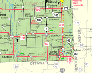 KDOT map of Cherokee County (legend) | |
| Coordinates: 37°18′32″N 94°46′27″W / 37.30889°N 94.77417°WCoordinates: 37°18′32″N 94°46′27″W / 37.30889°N 94.77417°W | |
| Country | United States |
| State | Kansas |
| County | Cherokee |
| Government | |
| • Mayor | Taylor Gravett [1] |
| Area[2] | |
| • Total | 0.94 sq mi (2.43 km2) |
| • Land | 0.94 sq mi (2.43 km2) |
| • Water | 0 sq mi (0 km2) |
| Elevation | 925 ft (282 m) |
| Population (2010)[3] | |
| • Total | 686 |
| • Estimate (2015)[4] | 647 |
| • Density | 730/sq mi (280/km2) |
| Time zone | CST (UTC-6) |
| • Summer (DST) | CDT (UTC-5) |
| ZIP code | 66781 |
| Area code | 620 |
| FIPS code | 20-76350 [5] |
| GNIS ID | 0469612 [6] |
Weir is a city in Cherokee County, Kansas, United States. As of the 2010 census, the city population was 686.[7]
History
Weir was founded in 1872.[8] It is named after landowner T. M. Weir, who donated forty acres as a townsite.[9][10] The first post office in Weir was established in 1875.[11]
Zinc has been mined at Weir since the town's beginning.[12] Weir was also one of the first locations in Kansas where coal was mined commercially.[13]
Geography
Weir is located at 37°18′32″N 94°46′27″W / 37.30889°N 94.77417°W (37.308768, -94.774289).[14] According to the United States Census Bureau, the city has a total area of 0.94 square miles (2.43 km2), all of it land.[2]
Weir is south of U.S. Route 400 and is located on K-103.
Climate
The climate in this area is characterized by hot, humid summers and generally mild to cool winters. According to the Köppen Climate Classification system, Weir has a humid subtropical climate, abbreviated "Cfa" on climate maps.[15]
Demographics
| Historical population | |||
|---|---|---|---|
| Census | Pop. | %± | |
| 1880 | 376 | — | |
| 1890 | 2,138 | 468.6% | |
| 1900 | 2,977 | 39.2% | |
| 1910 | 2,289 | −23.1% | |
| 1920 | 1,945 | −15.0% | |
| 1930 | 1,115 | −42.7% | |
| 1940 | 1,038 | −6.9% | |
| 1950 | 819 | −21.1% | |
| 1960 | 694 | −15.3% | |
| 1970 | 740 | 6.6% | |
| 1980 | 705 | −4.7% | |
| 1990 | 730 | 3.5% | |
| 2000 | 780 | 6.8% | |
| 2010 | 686 | −12.1% | |
| Est. 2015 | 647 | [4] | −5.7% |
| U.S. Decennial Census | |||
2010 census
As of the census[3] of 2010, there were 686 people, 266 households, and 176 families residing in the city. The population density was 729.8 inhabitants per square mile (281.8/km2). There were 309 housing units at an average density of 328.7 per square mile (126.9/km2). The racial makeup of the city was 94.5% White, 0.3% African American, 2.6% Native American, 0.9% from other races, and 1.7% from two or more races. Hispanic or Latino of any race were 2.2% of the population.
There were 266 households of which 31.2% had children under the age of 18 living with them, 50.0% were married couples living together, 10.5% had a female householder with no husband present, 5.6% had a male householder with no wife present, and 33.8% were non-families. 26.3% of all households were made up of individuals and 10.6% had someone living alone who was 65 years of age or older. The average household size was 2.58 and the average family size was 3.15.
The median age in the city was 38.8 years. 25.8% of residents were under the age of 18; 8.4% were between the ages of 18 and 24; 24.7% were from 25 to 44; 27.2% were from 45 to 64; and 14.1% were 65 years of age or older. The gender makeup of the city was 50.3% male and 49.7% female.
2000 census
As of the census[5] of 2000, there were 780 people, 310 households, and 212 families residing in the city. The population density was 745.3 people per square mile (286.8/km²). There were 352 housing units at an average density of 336.3 per square mile (129.4/km²). The racial makeup of the city was 97.31% White, 0.38% African American, 0.64% Native American, 0.26% from other races, and 1.41% from two or more races. Hispanic or Latino of any race were 0.77% of the population.
There were 310 households out of which 33.2% had children under the age of 18 living with them, 53.9% were married couples living together, 10.6% had a female householder with no husband present, and 31.6% were non-families. 25.5% of all households were made up of individuals and 13.5% had someone living alone who was 65 years of age or older. The average household size was 2.52 and the average family size was 3.05.
In the city the population was spread out with 27.8% under the age of 18, 7.8% from 18 to 24, 30.4% from 25 to 44, 21.7% from 45 to 64, and 12.3% who were 65 years of age or older. The median age was 36 years. For every 100 females there were 99.5 males. For every 100 females age 18 and over, there were 92.2 males.
The median income for a household in the city was $27,054, and the median income for a family was $35,476. Males had a median income of $26,406 versus $21,518 for females. The per capita income for the city was $16,561. About 8.7% of families and 13.2% of the population were below the poverty line, including 11.3% of those under age 18 and 11.4% of those age 65 or over.
Further reading
References
- ↑ http://www.joplinglobe.com/news/local_news/weir-mayor-predecessor-hold-many-things-in-common-age-party/article_cad1ac10-33d6-5713-908a-f09ba7e47b66.html
- 1 2 "US Gazetteer files 2010". United States Census Bureau. Retrieved 2012-07-06.
- 1 2 "American FactFinder". United States Census Bureau. Retrieved 2012-07-06.
- 1 2 "Annual Estimates of the Resident Population for Incorporated Places: April 1, 2010 to July 1, 2015". Retrieved July 2, 2016.
- 1 2 "American FactFinder". United States Census Bureau. Retrieved 2008-01-31.
- ↑ "US Board on Geographic Names". United States Geological Survey. 2007-10-25. Retrieved 2008-01-31.
- ↑ "2010 City Population and Housing Occupancy Status". U.S. Census Bureau. Retrieved December 3, 2011.
- ↑ Kansas State Historical Society (1916). Biennial Report of the Board of Directors of the Kansas State Historical Society. Kansas State Printing Plant. p. 157.
- ↑ Kansas Place-Names,John Rydjord, University of Oklahoma Press, 1972, ISBN 0-8061-0994-7
- ↑ "Profile for Weir, Kansas". ePodunk. Retrieved 6 June 2014.
- ↑ "Kansas Post Offices, 1828-1961 (archived)". Kansas Historical Society. Archived from the original on October 9, 2013. Retrieved 6 June 2014.
- ↑ Blackmar, Frank Wilson (1912). Kansas: A Cyclopedia of State History, Volume 2. Standard Publishing Company. p. 898.
- ↑ Roadside Kansas, Rex C. Buchanan and James R. McCauley, University Press of Kansas (Kansas Geological Survey), 1987, ISBN 0-7006-0322-0
- ↑ "US Gazetteer files: 2010, 2000, and 1990". United States Census Bureau. 2011-02-12. Retrieved 2011-04-23.
- ↑ Climate Summary for Weir, Kansas
External links
| Wikimedia Commons has media related to Weir, Kansas. |
- City
- Schools
- USD 247, local school district
- Maps
- Weir City Map, KDOT
Municipalities and communities of Cherokee County, Kansas, United States | ||
|---|---|---|
| Cities | 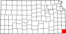 | |
| CDPs | ||
| Unincorporated communities | ||
| Ghost towns | ||
| Townships | ||
| Footnotes | ‡This populated place also has portions in an adjacent county or counties | |