Roseland, Kansas
| Roseland, Kansas | |
|---|---|
| City | |
 Location within Cherokee County and Kansas | |
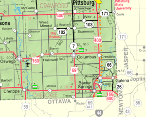 KDOT map of Cherokee County (legend) | |
| Coordinates: 37°16′50″N 94°51′5″W / 37.28056°N 94.85139°WCoordinates: 37°16′50″N 94°51′5″W / 37.28056°N 94.85139°W | |
| Country | United States |
| State | Kansas |
| County | Cherokee |
| Area[1] | |
| • Total | 0.80 sq mi (2.07 km2) |
| • Land | 0.80 sq mi (2.07 km2) |
| • Water | 0 sq mi (0 km2) |
| Elevation | 928 ft (283 m) |
| Population (2010)[2] | |
| • Total | 77 |
| • Estimate (2015)[3] | 74 |
| • Density | 96/sq mi (37/km2) |
| Time zone | CST (UTC-6) |
| • Summer (DST) | CDT (UTC-5) |
| ZIP code | 66773 |
| Area code | 620 |
| FIPS code | 20-61275 [4] |
| GNIS ID | 0469613 [5] |
Roseland is a city in Cherokee County, Kansas, United States. It was named after Louis Rose. As of the 2010 census, the city population was 77.[6]
Geography
Roseland is located at 37°16′50″N 94°51′5″W / 37.28056°N 94.85139°W (37.280671, -94.851489).[7] According to the United States Census Bureau, the city has a total area of 0.80 square miles (2.07 km2), all of it land.[1]
Roseland is on K-102, west of its junction with K-7.
Demographics
| Historical population | |||
|---|---|---|---|
| Census | Pop. | %± | |
| 1910 | 396 | — | |
| 1920 | 482 | 21.7% | |
| 1930 | 190 | −60.6% | |
| 1970 | 113 | — | |
| 1980 | 119 | 5.3% | |
| 1990 | 98 | −17.6% | |
| 2000 | 101 | 3.1% | |
| 2010 | 77 | −23.8% | |
| Est. 2015 | 74 | [3] | −3.9% |
| U.S. Decennial Census | |||
2010 census
As of the census[2] of 2010, there were 77 people, 37 households, and 21 families residing in the city. The population density was 96.3 inhabitants per square mile (37.2/km2). There were 48 housing units at an average density of 60.0 per square mile (23.2/km2). The racial makeup of the city was 97.4% White and 2.6% Native American.
There were 37 households of which 32.4% had children under the age of 18 living with them, 32.4% were married couples living together, 16.2% had a female householder with no husband present, 8.1% had a male householder with no wife present, and 43.2% were non-families. 32.4% of all households were made up of individuals and 18.9% had someone living alone who was 65 years of age or older. The average household size was 2.08 and the average family size was 2.52.
The median age in the city was 41.8 years. 19.5% of residents were under the age of 18; 7.8% were between the ages of 18 and 24; 27.3% were from 25 to 44; 28.6% were from 45 to 64; and 16.9% were 65 years of age or older. The gender makeup of the city was 42.9% male and 57.1% female.
2000 census
As of the census[4] of 2000, there were 101 people, 39 households, and 28 families residing in the city. The population density was 125.9 people per square mile (48.7/km²). There were 49 housing units at an average density of 61.1 per square mile (23.6/km²). The racial makeup of the city was 96.04% White, and 3.96% from two or more races.
There were 39 households out of which 30.8% had children under the age of 18 living with them, 51.3% were married couples living together, 10.3% had a female householder with no husband present, and 28.2% were non-families. 25.6% of all households were made up of individuals and 20.5% had someone living alone who was 65 years of age or older. The average household size was 2.59 and the average family size was 2.96.
In the city the population was spread out with 32.7% under the age of 18, 5.0% from 18 to 24, 29.7% from 25 to 44, 16.8% from 45 to 64, and 15.8% who were 65 years of age or older. The median age was 32 years. For every 100 females there were 80.4 males. For every 100 females age 18 and over, there were 100.0 males.
The median income for a household in the city was $25,000, and the median income for a family was $27,500. Males had a median income of $31,250 versus $12,917 for females. The per capita income for the city was $13,125. There were 11.1% of families and 10.3% of the population living below the poverty line, including 9.1% of under eighteens and 10.5% of those over 64.
Further reading
References
- 1 2 "US Gazetteer files 2010". United States Census Bureau. Retrieved 2012-07-06.
- 1 2 "American FactFinder". United States Census Bureau. Retrieved 2012-07-06.
- 1 2 "Annual Estimates of the Resident Population for Incorporated Places: April 1, 2010 to July 1, 2015". Retrieved July 2, 2016.
- 1 2 "American FactFinder". United States Census Bureau. Retrieved 2008-01-31.
- ↑ "US Board on Geographic Names". United States Geological Survey. 2007-10-25. Retrieved 2008-01-31.
- ↑ "2010 City Population and Housing Occupancy Status". U.S. Census Bureau. Retrieved December 3, 2011.
- ↑ "US Gazetteer files: 2010, 2000, and 1990". United States Census Bureau. 2011-02-12. Retrieved 2011-04-23.
External links
| Wikimedia Commons has media related to Roseland, Kansas. |
- City
- Schools
- USD 493, local school district
- Historical
- Maps
- Roseland City Map, KDOT
Municipalities and communities of Cherokee County, Kansas, United States | ||
|---|---|---|
| Cities | 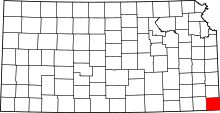 | |
| CDPs | ||
| Unincorporated communities | ||
| Ghost towns | ||
| Townships | ||
| Footnotes | ‡This populated place also has portions in an adjacent county or counties | |