Lowell Township, Cherokee County, Kansas
| Lowell Township | |
|---|---|
| Township | |
 Location in Cherokee County | |
| Coordinates: 37°06′15″N 094°40′01″W / 37.10417°N 94.66694°WCoordinates: 37°06′15″N 094°40′01″W / 37.10417°N 94.66694°W | |
| Country | United States |
| State | Kansas |
| County | Cherokee |
| Area | |
| • Total | 13.3 sq mi (34.44 km2) |
| • Land | 12.89 sq mi (33.4 km2) |
| • Water | 0.4 sq mi (1.05 km2) 3.05% |
| Elevation | 814 ft (248 m) |
| Population (2000) | |
| • Total | 672 |
| • Density | 52.1/sq mi (20.1/km2) |
| GNIS feature ID | 0469357 |
Lowell Township is a township in Cherokee County, Kansas, USA. As of the 2000 census, its population was 672.
Geography
Lowell Township covers an area of 13.3 square miles (34 km2) to the north and west of Galena. According to the USGS, it contains three cemeteries: Boston Mills, Hillcrest and Stevenson.
The streams of Shawnee Creek, Short Creek and Spring Branch run through this township.
References
External links
Municipalities and communities of Cherokee County, Kansas, United States | ||
|---|---|---|
| Cities | 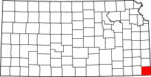 | |
| CDPs | ||
| Unincorporated communities | ||
| Ghost towns | ||
| Townships | ||
| Footnotes | ‡This populated place also has portions in an adjacent county or counties | |
This article is issued from Wikipedia - version of the 7/15/2016. The text is available under the Creative Commons Attribution/Share Alike but additional terms may apply for the media files.