Union Hill, Richmond, Virginia
|
Union Hill Historic District | |
 | |
 | |
| Location |
Roughly 20th, 21st, 22nd, 23rd, 24th 25th, Jessamine, Pink, Burton, Carrington, Cedar, Clay, Jefferson, Leigh, M, O, Sts Richmond, Virginia |
|---|---|
| Coordinates | 37°32′14″N 77°25′5″W / 37.53722°N 77.41806°WCoordinates: 37°32′14″N 77°25′5″W / 37.53722°N 77.41806°W |
| Architect | Anderson, D. Wiley; et al. |
| Architectural style | Federal, Greek Revival |
| NRHP Reference # | 02001670[1] |
| VLR # | 127-0815 |
| Significant dates | |
| Added to NRHP | December 31, 2002 |
| Designated VLR | December 5, 2001, April 30, 2008[2] |
Union Hill is a local Old and Historic District of Richmond, Virginia. As a neighborhood situated slightly north of the James River, it is located on the high western bluff above Shockoe Valley, just east of Downtown Richmond. The neighborhood is on the National Register of Historic Places.
Description
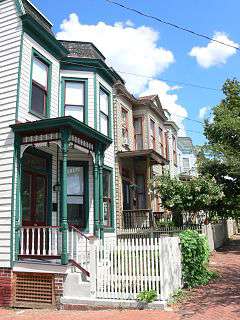
Among the many unique qualities exhibited by Union Hill, the fact that it is a complement to its high-style contemporary, Church Hill, is perhaps its strongest. While Church Hill is aligned in accordance with the early tradition of the Richmond grid, Union Hill retains character of geography. It is a neighborhood that displays not only vernacular architecture but also a special sort of vernacular land plan not regularly found in Richmond. Residents understand and appreciate these qualities about Union Hill and the impact that the preservation of this built environment can have upon the morals and character of future generations.[3]
Union Hill comprises a remarkable mix of homes, churches and commercial buildings are balanced along the irregular, picturesque and sometimes narrow streets that follow the curves of the original hilly terrain. Visitors may find a diverse mix of antebellum, Victorian, classical revival and modern architecture. A very small portion of existing buildings are noncontributing to the historic character of the neighborhood.[4] The community takes its name from the joining of two large hills via street grading that began in the late 1800s and continued through the early 1900s. The homes that line Jefferson Park have a clear view of downtown Richmond. Bordered on the south by Jefferson Avenue, on the north by Carrington and O Streets, on the east by 25th Street, and by Mosby on the west. Union Hill's history began early in the nineteenth century.
The Union Hill Historic District was added to the Virginia Landmarks Register in December 2001 and to the National Register of Historic Places in December 2002.[5] On November 23, 2009 Richmond City Council voted 8-1 to designate Union Hill as a City of Richmond Local Old and Historic District.[4]
References
- ↑ National Park Service (2008-04-15). "National Register Information System". National Register of Historic Places. National Park Service.
- ↑ "Virginia Landmarks Register". Virginia Department of Historic Resources. Retrieved 19 March 2013.
- ↑ Katie Kelley, Architectural Historian, Historic Richmond Foundation
- 1 2 Historic Richmond Foundation
- ↑ "National Register of Historic Places form" (PDF). Virginia Department of Historic Resources (April 8, 2008). Retrieved on 30 October 2008.
External links
 |
Fairmount | | ||
| Shockoe Valley | |
|||
| ||||
| | ||||
| Shockoe Bottom | Church Hill |

