U.S. Route 16A
| ||||
|---|---|---|---|---|
 | ||||
| Route information | ||||
| Auxiliary route of US 16 | ||||
| Defined by SDCL §31-4-139 | ||||
| Maintained by SDDOT | ||||
| Length: | 36.971 mi[1] (59.499 km) | |||
| Major junctions | ||||
| West end: |
| |||
| East end: |
| |||
| Location | ||||
| Counties: | Custer, Pennington | |||
| Highway system | ||||
| ||||

U.S. Route 16A (US 16A) is a scenic United States highway, which divides from U.S. Route 16 in the Black Hills of South Dakota. The highway's western terminus is a junction with US 16 and US 385 in Custer, South Dakota. The eastern terminus is at an interchange with US 16 called the Keystone Wye south of Rapid City, South Dakota.
Route description
The route passes through Keystone, South Dakota; Norbeck Wildlife Refuge; Mount Rushmore National Memorial; and Custer State Park (including State Game Lodge and Legion Lake); before rejoining the parent highway.

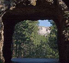
US 16A is famous for its scenic, one-lane tunnels aligned to frame the faces on Mount Rushmore, its "pigtail bridges", and its sections of divided highway but with single (and narrow) lanes on each roadway. It is the only route which can be used to drive through Custer State Park without having to pay an entrance fee for the park, provided the traveler does not stop in the Park.
Portions of US 16A are known as the Iron Mountain Road. The route includes most of the tunnels on the South Dakota state highway system, including the only four-lane tunnel in the state, just north of Keystone. Part of the highway is also a boundary of the Black Elk Wilderness. The Iron Mountain portion of the road is not maintained in the winter. The road, like several other scenic roads in the Black Hills, was originally laid out by Governor Peter Norbeck, specifically to create a very scenic, slow-speed road for tourists. The section of US 16A from SD 89 to SD 244 is known as the Peter Norbeck Memorial Byway in honor of the governor.[2] At the highest point of the byway, on the summit of Iron Mountain, there is a small memorial to Governor Norbeck.
History
An older road through the Badlands of South Dakota (now South Dakota Highway 240) was designated US 16A between 1944 and 1980.
Major intersections
| County | Location | mi[1] | km | Destinations | Notes |
|---|---|---|---|---|---|
| Custer | Custer | 0.000 | 0.000 | West end of SD 89 concurrency | |
| 0.804 | 1.294 | East end of SD 89 concurrency | |||
| Custer State Park | 6.447 | 10.375 | West end of SD 87 concurrency | ||
| 7.875 | 12.674 | East end of SD 87 concurrency | |||
| 16.226 | 26.113 | ||||
| Pennington | Mount Rushmore | 33.221 | 53.464 | ||
| Keystone | 34.321 | 55.234 | |||
| Keystone Wye | 36.971 | 59.499 | |||
1.000 mi = 1.609 km; 1.000 km = 0.621 mi
| |||||
References
- 1 2 "State Highway Log" (PDF). Rapid City region: South Dakota Department of Transportation. January 2011. pp. 37–42. Retrieved December 24, 2011.
- ↑ "The Unofficial South Dakota Highways Page: U.S. Route 16A". Retrieved 1 October 2014.