Spearfish Canyon

 |
| Black Hills and Badlands |
|---|
 |
| Sculpture |
| Geologic formations |
| Mountains |
|
| Caves |
| Parks, forests, and grassland |
| Lakes |
Spearfish Canyon is a deep but narrow gorge carved by Spearfish Creek just south of Spearfish, South Dakota in the U.S. It is located on the northern edge of Black Hills National Forest. Many tourists drive through the canyon, drawn to the region due to its wide range of plant and wildlife, geology, rock formations, and waterfalls. Spearfish Creek holds populations of rainbow and brown trout and is dammed in several spots, affording fishing opportunities. Stocking of trout in Spearfish Creek was discontinued in the 1970s and all trout in the creek today are wild. In addition, remnants of Spearfish Canyon's active mining history are still easily found in some locations.
Natural history
Approximately 600 million years ago in the Precambrian, the area was covered by a sea. As waters subsided and land masses began to appear 60 to 30 million years ago (between the Paleocene and Oligocene epochs), drainages such as Spearfish Canyon formed as softer rock was eroded away. Today, a National Scenic Byway, U.S. Highway 14A, winds through the canyon. This area is truly a crossroads, and trees and plants from Rocky Mountains, eastern woodlands, northern forests, and the Great Plains areas can be found here.
Flora and fauna
Of the 1,585 plant species found in South Dakota, 1,260 species are in the Black Hills, many of which can be found in Spearfish Canyon. Ponderosa pines are the most prominent vegetation in the Black Hills. As for bird species, turkeys, bluejays, woodpeckers, cliff swallows, chickadees, and golden or bald eagles are seen in the area. The canyon supports a cross-section of four-footed animal life. White-tail and mule deer can be found throughout the drive. Porcupines, raccoons, squirrels, and chipmunks might be spotted as well as a bobcat or a yellow-bellied marmot.
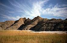
Geology
It is often studied by geologists due to the extreme old age of the Precambrian rocks exposed by the creek bed. The canyon's high walls are of three dominant rock types. The Cambrian to Ordovician Deadwood Shale at the bottom lies on an unconformity above Precambrian rock and can be identified by its brown color. It is multi-layered in appearance and ranges from 10 to 400 feet thick. Englewood Limestone in the middle is pink to red colored and is 30 to 60 feet thick. The Paleogene Paha Sapa Limestone, the top layer, is the thickest (300 to 600 feet) and is buff colored and weathered gray in appearance. Caves and fossils are frequently found in the Paha Sapa Limestone.
External links
- Basic information and pictures of Spearfish Canyon and tourism info
- Geologic information and pictures of Spearfish Canyon
- Information about the Scenic Byway
Coordinates: 44°28′39″N 103°51′01″W / 44.47750°N 103.85020°W