Belle Fourche, South Dakota
| Belle Fourche, South Dakota | |
|---|---|
| City | |
|
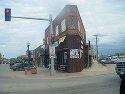
Business District of Belle Fourche | |
 Location in Butte County (top) and South Dakota (bottom) | |
 Belle Fourche, South Dakota Location in the United States | |
| Coordinates: 44°40′3″N 103°51′1″W / 44.66750°N 103.85028°WCoordinates: 44°40′3″N 103°51′1″W / 44.66750°N 103.85028°W | |
| Country | United States |
| State | South Dakota |
| County | Butte |
| Incorporated | 1903[1] |
| Government | |
| • Mayor | Gloria Landphere |
| Area[2] | |
| • Total | 8.60 sq mi (22.27 km2) |
| • Land | 8.53 sq mi (22.09 km2) |
| • Water | 0.07 sq mi (0.18 km2) |
| Elevation | 3,022 ft (921 m) |
| Population (2010)[3] | |
| • Total | 5,594 |
| • Estimate (2015)[4] | 5,696 |
| • Density | 655.8/sq mi (253.2/km2) |
| Time zone | MST (UTC-7) |
| • Summer (DST) | MDT (UTC-6) |
| ZIP Code | 57717 |
| Area code(s) | 605 |
| FIPS code | 46-04380[5] |
| GNIS feature ID | 1265119[6] |
| Website | bellefourche.org |
Belle Fourche (/bɛlˈfuːʃ/; bel-FOOSH)[7] is a city in and the county seat of Butte County, South Dakota, United States.[8] The population was 5,594 at the 2010 census.
The city is near the geographic center of the 50 U.S. states.
History
Belle Fourche (French for "beautiful fork")[9] was named by French explorers coming from New France, referring to the confluence of what is now known as the Belle Fourche and Redwater Rivers and the Hay Creek. Beaver trappers worked these rivers until the mid-19th century, and Belle Fourche became a well known fur trading rendezvous point. During and after the gold rush of 1876, farmers and ranchers alike settled in the fertile valleys, growing food for the miners and their work animals. At the same time, the open plains for hundred of miles in all directions were being filled by huge herds of Texas and Kansas cattle. Towns sprang up to serve the ever-changing needs of the farmers and ranchers. In 1884, the Marquis de Mores, a French nobleman and contemporary of Theodore Roosevelt, established a stagecoach line between Medora, North Dakota, and Deadwood, South Dakota. The Belle Fourche way station included a stage barn and a saloon.

Knowing the cattle barons and the railroad would need a point at which to load the herds of cattle onto freight cars for shipment to the packing plants in the Midwest, Seth Bullock provided a solution and became the parent, in effect, of Belle Fourche, the city. After serving in the Montana legislature in 1871–1873 (and being instrumental in the establishment of a National Park at Yellowstone), he had come to the Black Hills to cash in on selling supplies to the Deadwood miners, arriving August 2, 1876, the day Wild Bill Hickok was murdered.
During the next 14 years, Bullock acquired land as homesteaders along the Belle Fourche River "proved up" and sold out. When the railroad came to the Hills and refused to pay the prices demanded by the nearby township of Minnesela, he was ready. Seth offered the railroad free right-of-way and offered to build the terminal if the railroad would locate it at a point on his land, near where the present Belle Fourche Livestock Exchange exists. In 1890, the first train load of cattle headed east. By 1895, Belle Fourche was shipping 2,500 carloads of cattle per month in the peak season, making it the world's largest livestock-shipping point. This was the start of the agriculture center of the Tri-State area for which Belle Fourche would become known.
After winning a competition with Minnesela over the railroad which now goes through Belle Fourche, Bullock's town went on to win the county seat in the election of 1894. Still, cowboys rode into Minnesela and stole the county books.
Belle Fourche today serves a large trade area of ranches and farms. The wool, cattle, and bentonite industries have been important to the growth of Belle Fourche. The city serves as gateway to the northern Black Hills.[10]
Geography
According to the United States Census Bureau, the city has a total area of 8.60 square miles (22.27 km2), of which, 8.53 square miles (22.09 km2) is land and 0.07 square miles (0.18 km2) is water.[2]
Geographic center of U.S.
In 1959, the U.S. Coast and Geodetic Survey officially designated a point 20 miles north of Belle Fourche as the geographic center of the United States. It is the center of the nation because the admission of Alaska and Hawaii to the United States moved the location of the official center of the nation. The geographic center of the 48 contiguous U.S. states is Lebanon, Kansas.
Climate
| Climate data for Belle Fourche, South Dakota | |||||||||||||
|---|---|---|---|---|---|---|---|---|---|---|---|---|---|
| Month | Jan | Feb | Mar | Apr | May | Jun | Jul | Aug | Sep | Oct | Nov | Dec | Year |
| Record high °F (°C) | 72 (22) |
73 (23) |
82 (28) |
93 (34) |
97 (36) |
107 (42) |
110 (43) |
108 (42) |
107 (42) |
94 (34) |
83 (28) |
74 (23) |
110 (43) |
| Average high °F (°C) | 39 (4) |
41 (5) |
50 (10) |
62 (17) |
70 (21) |
81 (27) |
89 (32) |
88 (31) |
78 (26) |
64 (18) |
48 (9) |
38 (3) |
62.3 (16.9) |
| Average low °F (°C) | 13 (−11) |
15 (−9) |
23 (−5) |
33 (1) |
43 (6) |
52 (11) |
58 (14) |
56 (13) |
45 (7) |
34 (1) |
23 (−5) |
13 (−11) |
34 (1) |
| Record low °F (°C) | −35 (−37) |
−32 (−36) |
−30 (−34) |
−1 (−18) |
15 (−9) |
29 (−2) |
37 (3) |
36 (2) |
18 (−8) |
−12 (−24) |
−26 (−32) |
−44 (−42) |
−44 (−42) |
| Average precipitation inches (mm) | 0.36 (9.1) |
0.48 (12.2) |
1.16 (29.5) |
1.98 (50.3) |
3.10 (78.7) |
2.81 (71.4) |
2.00 (50.8) |
1.42 (36.1) |
1.52 (38.6) |
1.61 (40.9) |
0.77 (19.6) |
0.63 (16) |
17.84 (453.1) |
| Source: The Weather Channel (Historical Monthly Averages) [11] | |||||||||||||
Demographics
| Historical population | |||
|---|---|---|---|
| Census | Pop. | %± | |
| 1900 | 451 | — | |
| 1910 | 1,352 | 199.8% | |
| 1920 | 1,616 | 19.5% | |
| 1930 | 2,032 | 25.7% | |
| 1940 | 2,496 | 22.8% | |
| 1950 | 3,540 | 41.8% | |
| 1960 | 4,087 | 15.5% | |
| 1970 | 4,236 | 3.6% | |
| 1980 | 4,692 | 10.8% | |
| 1990 | 4,335 | −7.6% | |
| 2000 | 4,565 | 5.3% | |
| 2010 | 5,594 | 22.5% | |
| Est. 2015 | 5,696 | [12] | 1.8% |
| U.S. Decennial Census[13] 2015 Estimate[4] | |||
2010 census
As of the census[3] of 2010, there were 5,594 people, 2,322 households, and 1,461 families residing in the city. The population density was 655.8 inhabitants per square mile (253.2/km2). There were 2,511 housing units at an average density of 294.4 per square mile (113.7/km2). The racial makeup of the city was 93.6% White, 0.2% African American, 2.1% Native American, 0.3% Asian, 0.1% Pacific Islander, 1.3% from other races, and 2.6% from two or more races. Hispanic or Latino of any race were 4.1% of the population.
There were 2,322 households of which 32.8% had children under the age of 18 living with them, 46.0% were married couples living together, 12.0% had a female householder with no husband present, 5.0% had a male householder with no wife present, and 37.1% were non-families. 32.6% of all households were made up of individuals and 13% had someone living alone who was 65 years of age or older. The average household size was 2.36 and the average family size was 2.96.
The median age in the city was 36.1 years. 26.2% of residents were under the age of 18; 9.2% were between the ages of 18 and 24; 23.6% were from 25 to 44; 25.6% were from 45 to 64; and 15.6% were 65 years of age or older. The gender makeup of the city was 48.9% male and 51.1% female.
2000 census
As of the census[5] of 2000, there were 4,565 people, 1,854 households, and 1,186 families residing in the city. The population density was 1,446.9 people per square mile (557.8/km²). There were 2,122 housing units at an average density of 672.6 per square mile (259.3/km²). The racial makeup of the city was 95.03% White, 0.15% African American, 1.91% Native American, 0.33% Asian, 1.27% from other races, and 1.31% from two or more races. Hispanic or Latino of any race were 3.70% of the population.
There were 1,854 households out of which 32.4% had children under the age of 18 living with them, 50.2% were married couples living together, 10.9% had a female householder with no husband present, and 36.0% were non-families. 30.5% of all households were made up of individuals and 14.3% had someone living alone who was 65 years of age or older. The average household size was 2.41 and the average family size was 3.04.
In the city the population was spread out with 27.2% under the age of 18, 8.2% from 18 to 24, 25.5% from 25 to 44, 21.8% from 45 to 64, and 17.3% who were 65 years of age or older. The median age was 38 years. For every 100 females there were 91.2 males. For every 100 females age 18 and over, there were 85.5 males.
As of 2000 the median income for a household in the city was $26,875, and the median income for a family was $35,506. Males had a median income of $26,763 versus $15,275 for females. The per capita income for the city was $14,051. About 9.0% of families and 12.6% of the population were below the poverty line, including 19.8% of those under age 18 and 7.7% of those age 65 or over.
Radio and TV stations
|
AM radio |
FM radio |
Television |
Popular culture
In the movie The Cowboys (1972) starring John Wayne, the final destination of the cattle drive was Belle Fourche.
Notable people
- Lloyd Eaton, former resident, football player, executive, and coach
- Jason Kubel, born in Belle Fourche, retired Major League Baseball player for the Minnesota Twins (2004, 2006 - 2011, 2014), Arizona Diamondbacks (2012 - 2013), & Cleveland Indians (2013)
- Lem Overpeck, born in Belle Fourche, 29th Lieutenant Governor of South Dakota
- Bill Pearson, born in Belle Fourche, comics artist
- Emily E. Sloan, former resident, rancher, lawyer, author
- John Strohmayer, born in Belle Fourche, former baseball pitcher for the Oakland Athletics, Montreal Expos, and New York Mets
- Francis Townsend, former resident, physician
See also
References
- ↑ "SD Towns" (PDF). South Dakota State Historical Society. Archived from the original (PDF) on 10 February 2010. Retrieved 2010-02-11.
- 1 2 "US Gazetteer files 2010". United States Census Bureau. Archived from the original on 2012-01-24. Retrieved 2012-06-21.
- 1 2 "American FactFinder". United States Census Bureau. Retrieved 2012-06-21.
- 1 2 "Population Estimates". United States Census Bureau. Retrieved June 7, 2016.
- 1 2 "American FactFinder". United States Census Bureau. Archived from the original on 2013-09-11. Retrieved 2008-01-31.
- ↑ "US Board on Geographic Names". United States Geological Survey. 2007-10-25. Retrieved 2008-01-31.
- ↑ "Broadcast Pronunciation Guide and South Dakota Pronunciations". Associated Press. Retrieved 2009-11-10.
- ↑ "Find a County". National Association of Counties. Archived from the original on 2012-07-12. Retrieved 2011-06-07.
- ↑ Chicago and North Western Railway Company (1908). A History of the Origin of the Place Names Connected with the Chicago & North Western and Chicago, St. Paul, Minneapolis & Omaha Railways. p. 43.
- ↑ Information was taken from the Belle Fourche America's Hometown Booklet (1998)
- ↑ "Climate Statistics for Belle Fourche, SD". The Weather Channel. Retrieved June 22, 2014.
- ↑ "Annual Estimates of the Resident Population for Incorporated Places: April 1, 2010 to July 1, 2015". Retrieved July 2, 2016.
- ↑ United States Census Bureau. "Census of Population and Housing". Archived from the original on May 11, 2015. Retrieved October 4, 2014.
External links
- City of Belle Fourche
- Belle Fourche Chamber of Commerce
- Belle Fourche Post & Bee, local newspaper
- Belle Fourche School District
- "Tale of Two Towns"
- Belle Fourche
- In the Middle of Nowhere, a Nation’s Center, New York Times
Municipalities and communities of Butte County, South Dakota, United States | ||
|---|---|---|
| Cities | 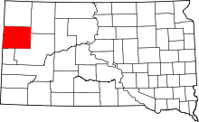 | |
| Towns | ||
| Townships | ||
| Unorganized territories |
| |
| CDP | ||
| Other unincorporated communities | ||
| Ghost town | ||