Hanna, South Dakota
| Hanna, South Dakota | |
|---|---|
| Unincorporated community | |
 Hanna Location in the U.S. state of South Dakota | |
| Coordinates: 44°15′42″N 103°50′41″W / 44.26167°N 103.84472°WCoordinates: 44°15′42″N 103°50′41″W / 44.26167°N 103.84472°W | |
| Country | United States |
| State | South Dakota |
| County | Lawrence |
| Elevation | 5,669 ft (1,728 m) |
| Time zone | Mountain (MST) (UTC-7) |
| • Summer (DST) | MDT (UTC-6) |
| Area code(s) | 605 |
| GNIS feature ID | 1261765[1] |
Hanna is a small unincorporated community in Lawrence County, South Dakota, United States. It is located along the Hanna Road in the Black Hills of South Dakota. The small settlement or village is south of the Hanna Campground and west-southwest of the Lead Country Club. The community is located about twelve miles southwest of Lead, South Dakota.
History
Hanna was founded in 1904. It was named in honor of a United States Senator, Marc Hanna of Ohio, who died shortly before the community was founded. At one time, a branch of the Chicago, Burlington & Quincy Railroad ran through the town. The community now contains a pumping station for the Homestake Mine.[2]
Geography
Hanna is located at (44.261667, -103.844722).[3]
Climate
| Climate data for Hanna, SD | |||||||||||||
|---|---|---|---|---|---|---|---|---|---|---|---|---|---|
| Month | Jan | Feb | Mar | Apr | May | Jun | Jul | Aug | Sep | Oct | Nov | Dec | Year |
| Record high °F (°C) | 69 (21) |
66 (19) |
74 (23) |
84 (29) |
88 (31) |
96 (36) |
99 (37) |
98 (37) |
96 (36) |
84 (29) |
74 (23) |
65 (18) |
99 (37) |
| Average high °F (°C) | 36 (2) |
37 (3) |
43 (6) |
52 (11) |
61 (16) |
71 (22) |
79 (26) |
78 (26) |
68 (20) |
55 (13) |
43 (6) |
35 (2) |
54.8 (12.8) |
| Daily mean °F (°C) | 27 (−3) |
28 (−2) |
33 (1) |
42 (6) |
51 (11) |
60 (16) |
68 (20) |
67 (19) |
57 (14) |
45 (7) |
34 (1) |
26 (−3) |
44.8 (7.3) |
| Average low °F (°C) | 17 (−8) |
18 (−8) |
23 (−5) |
31 (−1) |
40 (4) |
49 (9) |
56 (13) |
55 (13) |
45 (7) |
34 (1) |
24 (−4) |
16 (−9) |
34 (1) |
| Record low °F (°C) | −27 (−33) |
−32 (−36) |
−17 (−27) |
−5 (−21) |
9 (−13) |
24 (−4) |
36 (2) |
22 (−6) |
15 (−9) |
−5 (−21) |
−16 (−27) |
−33 (−36) |
−33 (−36) |
| Average precipitation inches (mm) | 1.34 (34) |
1.65 (41.9) |
2.58 (65.5) |
3.55 (90.2) |
4.64 (117.9) |
3.57 (90.7) |
2.76 (70.1) |
2.09 (53.1) |
1.99 (50.5) |
3.04 (77.2) |
1.83 (46.5) |
1.51 (38.4) |
30.55 (776) |
| Source: The Weather Channel (Historical Monthly Averages)[4] | |||||||||||||
References
- ↑ "US Board on Geographic Names". United States Geological Survey. 2007-10-25. Retrieved 2008-01-31.
- ↑ Parker, Watson; Lambert, Hugh K. (1974). Black Hills Ghost Towns (1st ed.). Chicago, IL: The Swallow Press. p. 108. ISBN 0-8040-0637-7.
- ↑ "US Gazetteer files: 2010, 2000, and 1990". United States Census Bureau. 2011-02-12. Retrieved 2011-04-23.
- ↑ "Monthly Averages for Hanna, SD". Retrieved October 25, 2013.
External links
Municipalities and communities of Lawrence County, South Dakota, United States | ||
|---|---|---|
| Cities | 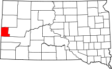 | |
| Township | ||
| CDPs | ||
| Other unincorporated communities | ||
| Ghost towns | ||
This article is issued from Wikipedia - version of the 4/24/2016. The text is available under the Creative Commons Attribution/Share Alike but additional terms may apply for the media files.