Trần Văn Thời District
| Trần Văn Thời District Huyện Trần Văn Thời | |
|---|---|
| Rural district | |
 Districts of Cà Mau Province | |
| Country |
|
| Province | Cà Mau |
| Capital | Trần Văn Thời |
| Area | |
| • Total | 300 sq mi (700 km2) |
| Population (2003) | |
| • Total | 191,718 |
| Time zone | UTC + 7 (UTC+7) |
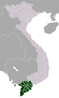
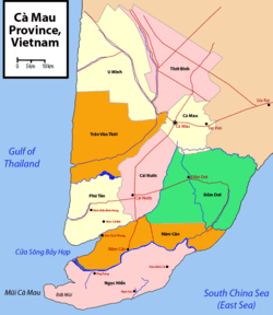
Trần Văn Thời is a rural district (huyện) of Cà Mau Province in the Mekong Delta region of Vietnam. As of 2003, the district had a population of 191,718.[1] The area spans a distance of 700 km². The district capital lies at Trần Văn Thời.[1]
Tran Van Thoi is located in the western coast of the province and borders the Gulf of Thailand, the districts of U Minh to the north and Cà Mau City to the east, and Phú Tân to the south.
The Ông Đốc river flows through the district into the see.
The main industries in the district are fisheries and agro-forestry. This includes fisheries and aquaculture on the sea. Farm forestry is mainly growing grain and rice, and vegetables.
Divisions
The district is divided into communes:
Trần Văn Thời, Sông Đốc, Khánh Bình Tây Bắc, Khánh Bình Tây, Trần Hợi, Khánh Bình, Khánh Hưng, Khánh Bình Đông, Khánh Hải, Lợi An, Phong lạc, Phong Điền, Khánh Lộc
References
- 1 2 "Districts of Vietnam". Statoids. Retrieved March 13, 2009.
Coordinates: 9°10′01″N 104°55′01″E / 9.167°N 104.917°E