Bến Tre Province
| Bến Tre Province Tỉnh Bến Tre | |
|---|---|
| Province | |
|
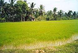
Bến Tre countryside around Cái Mon | |
| Nickname(s): Bamboo Landing | |
 Location of Bến Tre within Vietnam | |
| Coordinates: 10°10′N 106°30′E / 10.167°N 106.500°ECoordinates: 10°10′N 106°30′E / 10.167°N 106.500°E | |
| Country |
|
| Region | Mekong Delta |
| Capital | Bến Tre |
| Government | |
| • People's Council Chair | Nguyễn Hữu Phước |
| • People's Committee Chair | Nguyen Thi Thanh Ha |
| Area | |
| • Total | 2,321.6 km2 (896.4 sq mi) |
| Population (2004) | |
| • Total | 1,345,600 |
| • Density | 580/km2 (1,500/sq mi) |
| Demographics | |
| • Ethnicities | Vietnamese, Khmer, Hòa, Tày |
| Time zone | ICT (UTC+7) |
| Calling code | 75 |
| ISO 3166 code | VN-50 |
| Website | Official website |
Bến Tre (![]() listen) is a province of Vietnam. It is one of the country's southern provinces, being situated in the Mekong Delta.
listen) is a province of Vietnam. It is one of the country's southern provinces, being situated in the Mekong Delta.
Administrative divisions
Bến Tre is subdivided into 9 district-level sub-divisions:
- 8 districts:
- 1 provincial city:
- Bến Tre (capital)
They are further subdivided into 7 commune-level towns (or townlets), 147 communes, and 10 wards. See also List of communes in Bến Tre Province.
Geography

Geographically, Bến Tre is wedged between the two main branches of the Tiền Giang River, which is itself one of the two main branches of the Mekong. The province's northern boundary is formed by the Tiền Giang's main course, while the province's southern boundary is formed by the Tiền Giang's largest branch (which breaks away from the Tiền Giang just upriver from Bến Tre province). Between the Tiền Giang and its main branch are two smaller branches, passing through the middle of Bến Tre.
The entire province is criss-crossed with a network of smaller rivers and canals. The extensive irrigation that this provides makes Bến Tre a major producer of rice, but also means that the area is prone to flooding. The Climate Change Research Institute at Cần Thơ University, in studying the possible consequences of climate change, has predicted that 51% of Bến Tre province can be expected to be flooded if sea levels rise by 1 meter.[1] Bến Tre Province is, on average, only 1.25 metres above sea level.
Transportation
Construction on the Rạch Miễu Bridge, which links Bến Tre to its northern neighbour, Tiền Giang Province, was started in 2002. The bridge was finished and opened for traffic on 19 January 2009. Before that time, Bến Tre was only accessible to automobiles via ferry.
Start of the Vietnam War
In what has been called "the start of the Vietnam War", in January and February 1960 the Viet Cong attacked and took temporary control of several districts in Kiến Hòa Province province (now Bến Tre Province).[2] The Viet Cong set up "people's committees," and confiscated land from landlords and redistributed it to poor farmers. One of the leaders of the uprising was Madame Nguyễn Thị Định who led the all-female "Long Hair Army." Dinh was the secretary of the Ben Tre Communist Party and later a Viet Cong Major General.[3]
Although the South Vietnamese army (ARVN) recaptured the villages, uprisings spread to many other areas of South Vietnam. The uprisings were spontaneous rather than planned, as the official policy of the Communist government in Hanoi was that the Viet Cong's stance should be restrained and defensive, not offensive.[4]
References
- ↑ "Mekong Delta: more flood and drought" Archived May 5, 2010, at the Wayback Machine.. VietnamNet Bridge. 19 March 2009.
- ↑ Pringle, James, "Meanwhile: The quiet town where the Vietnam War began", The New York Times, 223 March 2004
- ↑ "Ben Tre Province", , accessed 2 Dec 1963
- ↑ Asselin, Pierre Hanoi's Road to the Vietnam War, 1954-1965 Berkeley: University of California Press, 2013, p. 73
External links
- Bến Tre website (in English)
- Bến Tre website (in Vietnamese)
- Bến Tre Province profile
- Website Thành phố Bến Tre - Ben Tre City
 |
Tiền Giang Province | Tiền Giang Province | Bà Rịa-Vũng Tàu Province | |
| Vĩnh Long Province | |
East Sea | ||
| ||||
| | ||||
| Trà Vinh Province | Trà Vinh Province | East Sea |