Cà Mau
| Cà Mau Thành phố Cà Mau | |
|---|---|
|
Cà Mau seen from the air | |
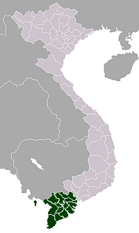
 Cà Mau Location of in Vietnam | |
| Coordinates: 9°11′N 105°9′E / 9.183°N 105.150°E | |
| Country |
|
| Province | Cà Mau |
| Area[1] | |
| • Land | 250.3 km2 (96.6 sq mi) |
| Population (2015) | |
| • Total | 278,395 |
| • Density | 1,112.2/km2 (2,881/sq mi) |
| [1] | |
| Website | Tỉnh Cà Mau |

Cà Mau (![]() listen) is a city in southern Vietnam. It is the capital of Cà Mau Province, a province in the Mekong Delta region, in the southernmost part of Vietnam's inland territory. Vietnam's incumbent Prime Minister Nguyen Tan Dung was born and raised here. The city is characterized by its system of transport canals and most goods are transported here by boats and barges.
listen) is a city in southern Vietnam. It is the capital of Cà Mau Province, a province in the Mekong Delta region, in the southernmost part of Vietnam's inland territory. Vietnam's incumbent Prime Minister Nguyen Tan Dung was born and raised here. The city is characterized by its system of transport canals and most goods are transported here by boats and barges.
The city's population is approximately 204,895 (as of 2010).[1] The majority of its residents is ethnic Vietnamese, with 300 Khmer Krom households and 400 Hoa households. Cà Mau city is accessible by road (360 km south-west of Ho Chi Minh City) via National Route 1A or by air (Cà Mau Airport). Cà Mau is administratively subdivided into 8 urban phuong and 7 rural xa.[2]
Economy
Cà Mau is Vietnam's biggest exporter of shrimp and prawns. In 2005, Cà Mau province alone exported about $500 million of shrimp and prawns. A large petroleum project under construction, the Cà Mau Gas-Power-Fertilizer Complex, is valued at $ 1.4 billion. It includes:
- 2 thermal power plants with total capacity of 1500 MW (equipment provided by the German company Siemens)
- A fertilizer plant with production capacity at 800,000 metric tonnes of urea/year, and
- A gas pipeline 18 inches in diameter to extend 298 km offshore and with 27 km onshore piping in gas from the PM3 gas field shared with Malaysia. Two billion cubic meters of gas are piped to feed these plants per year.
The project opened in December 2008.[3]
Tourism

Cà Mau has several attractions that draw domestic and international tourists. These include several wild bird parks, the southernmost point in Vietnam (called Mũi Cà Mau), and a number of Khmer pagodas. Near Cà Mau is the U Minh area with its famous mangrove forest and swamp cuisine: fish hot pots, Vietnamese, Chinese, and Khmer cuisine. Cà Mau also has several 1- to 3-star hotel restaurants.
History
The region of the present Cà Mau province was once a territory of the Kingdom of Funan (in Vietnamese: Vương quốc Phù Nam), which included Laos, Cambodia, and extended east to Thailand, and southern Vietnam (Vietnamese: Nam Bộ). This region later became a part of the Chan La Kingdom (in Vietnamese: Chân Lạp) and the Khmer Empire, which included Cambodia, eastern Thailand, and southern Vietnam. In 1757, the land belonging to Cà Mau province (in Khmer language "the black land") was ceded by the Chan Lap king to the Nguyễn lord of Vietnam with an early settlement of Khmer, Chinese and Vietnamese. During the French colonial period, Cà Mau was only a small town. During the Vietnam War, the area nearby Cà Mau was a stronghold (in Vietnamese: Chiến khu cách mạng) for the National Front for the Liberation of Vietnam also known as the Viet Cong, a Hanoi-backed guerrilla group fighting the United States Army and the South Vietnamese government during the Vietnam War. After 1975, Cà Mau was made the administrative seat and the governmental center of Minh Hải Province, which included Cà Mau and Bạc Liêu Province). In 1995, Cà Mau province broke off from Minh Hải Province with Cà Mau its capital. In 1999, the prime minister by a decree recognized Cà Mau (in Vietnamese: Thị xã) as a city – Cà Mau city (3rd class urban area as per Vietnamese laws).[2] In 2010, the Prime Minister further upgraded Cà Mau to a 2nd class urban area.[4]
Transportation
Cà Mau is served by Cà Mau Airport.
References
- 1 2 3 Nghị quyết số 24/NQ-CP ngày 04 tháng 6 năm 2009 của Chính phủ Việt Nam.
- 1 2 "Thành phố Cà Mau". Ủy ban Nhân dân Thành phố Cà Mau (Cà Mau City People's Committee).
- ↑ VietNamNet Bridge. English.vietnamnet.vn. Retrieved on 15 November 2011.
- ↑ Life. Nhan Dan. Retrieved on 15 November 2011.
Gallery
 The Monument at the downtown Cà Mau City, surrounded with Provincial Administrative Hall, Central Post Office and several banks
 Phan Ngoc Hien street in Cà Mau Central
 Cà Mau city downtown viewed from the air
 A main street in Cà Mau city
 Cà Mau city
External links
| Wikimedia Commons has media related to Ca Mau. |
Coordinates: 9°11′N 105°09′E / 9.183°N 105.150°E
| Cà Mau |  | |
|---|---|---|
| Cái Nước |
| |
| Đầm Dơi | ||
| Năm Căn | ||
| Ngọc Hiển | ||
| Phú Tân | ||
| Thới Bình | ||
| Trần Văn Thời | ||
| U Minh | ||