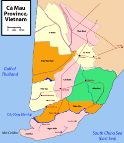
U Minh District
| U Minh District Huyện U Minh | |
|---|---|
| Rural district | |
 Districts of Cà Mau Province | |
| Country |
|
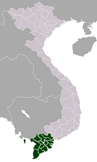
| Province | Cà Mau |
| Capital | U Minh |
| Area | |
| • Total | 295 sq mi (764 km2) |
| Population (2003) | |
| • Total | 91,438 |
| Time zone | UTC + 7 (UTC+7) |
U Minh is a rural district (huyện) of Cà Mau Province in the Mekong Delta region of Vietnam. As of 2003, the district had a population of 91,438.[1] The district covers an area of 764 km². The district capital lies at U Minh.[1]
U Minh is famous for its salty mangroves. It is the site of a large gas and electricity facility for the region in Khánh An commune. Transport in the district is mainly through waterways, as it is in a river delta region, and roads are poorly developed. A 14-km-long, 2-lane paved road connects U Minh district with Cà Mau City. Along with nearby U Minh Thượng, U Minh is known for its forests.
It is located on Vietnam's western coast on the Cà Mau Peninsula, abutting the Gulf of Thailand. It is bordered by U Minh Thượng District to the north in Kiên Giang Province, and the districts of Trần Văn Thời to the south and Thới Bình to the east.
The terrain is mostly flat floodplains, and is salty.
Divisions
The district is divided into communes:
U Minh, Nguyễn Phích, Khánh Hội, Khánh Hòa, Khánh Tiến, Khánh Lâm, Khánh An.
References
- 1 2 "Districts of Vietnam". Statoids. Retrieved March 13, 2009.
Coordinates: 9°25′01″N 104°55′01″E / 9.417°N 104.917°E