Cần Đước District
| Cần Đước District Huyện Cần Đước | |
|---|---|
| District | |
| Country |
|
| Region | Mekong Delta |
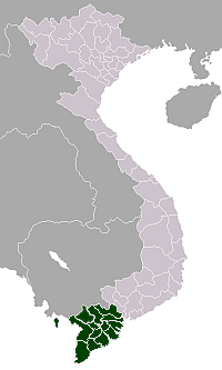
| Province | Long An |
| Capital | Cần Đước |
| Area | |
| • Total | 71 sq mi (185 km2) |
| Population (2003) | |
| • Total | 169,391 |
| Time zone | Indochina Time (UTC+07:00) |
Can Duoc is a rural district (huyện) of Long An Province in the Mekong River Delta region of Vietnam. Cần Đước locates in the south of Long An. It covers an area of 205,504 km2. The total population of the district is 160,000 people. The population density is around 775 people/km². Cần Đước is famous for its Nàng Thơm Chợ Đào Rice.
Divisions
The district is divided into communes:
Cần Đước (urban), Long Hựu Đông, Long Hựu Tây, Phước Đông, Tân Chánh, Tân Ân, Tân Lân, Mỹ Lệ, Phước Tuy, Long Trạch, Long Hoà, Tân trạch, Long Sơn, Phước Vân, Long Định, Long Cang, Long Khê
As of 2003 the district had a population of 169,391 .[1] The district covers an area of 185 km². The district capital lies at Cần Đước.[1]
History
At the beginning, Cần Đước was a small village located in a peninsula created by the Muong Ong Quynh and Rach Ben Ba distributary. In 1698, the present-day Cần Đước belonged to fort Phien Tran. In 1808, it belonged to the town of Phien An. In 13th year of Minh Mạng (1832), Cần Đước became part of Phuoc Loc county, phu (old subdivision of a province but larger than a county) Tân An, Gia Dinh province. In 1867, Cần Đước became a county itself when Phuoc Loc became a phu. In 1871, Phuc Loc was merged into Cho Lon province.
Located in center of Gò Công, Can Giuoc, and Saigon, Cần Đước is a major rice growing area. It became a major stronghold for Truong Dinh's guerrilla campaign in southern Vietnam. This campaign is one of the earlies rebellion against the French invasion in defiance of Emperor Tự Đức who signed the Treaty of Saigon which ceded the three southern provinces of Gia Dinh, Dinh Tuong and Biên Hòa to France. They became the colony of Cochinchina. Truong Dinh refused to recognise the treaty and continued his guerrilla attacks against French patrols and their Vietnamese collaborators. During this time, many Cần Đước natives became part of the guerrilla leadership. Thong binh duong Bui Quan Dieu, who command the famous battle of Can Giouc is from Cần Đước. Nguyen Van Tien is another Can Duoc natives who led server groups of guerrilla in the area. He was later captured and killed by the French. After the death of Truong Dinh on August 19, 1864, Can Duoc became part of another guerrilla campaign against the French authority which was led by Nguyen Trung Truc.
In the early 20th century, Cần Đước became parts of many nationalist movements such as Thiên Địa Hội or Nguyễn An Ninh society.
After the end of the First Indochina War, Can Duoc became a county part of the Cho Lon province in 1954 under the new state of South Vietnam. In 1956, Tân An and part of Cho Lon separated into a new province called Long An. Cần Đước then became a county part of the Long An province. The government divided Can Duoc into two districts: Cần Đước and Rach Kien.
After the end of the Second Indochina War (Vietnam War), Cần Đước restored its original boundary as it is today.
References
- 1 2 "Districts of Vietnam". Statoids. Retrieved March 13, 2009.
Coordinates: 10°32′21″N 106°36′33″E / 10.53917°N 106.60917°E