Touët-sur-Var
| Touët-sur-Var | ||
|---|---|---|
|
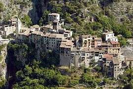
The upper village of Touët-sur-Var | ||
| ||
 Touët-sur-Var | ||
|
Location within Provence-A.-C.d'A. region  Touët-sur-Var | ||
| Coordinates: 43°56′53″N 7°00′25″E / 43.9481°N 7.0069°ECoordinates: 43°56′53″N 7°00′25″E / 43.9481°N 7.0069°E | ||
| Country | France | |
| Region | Provence-Alpes-Côte d'Azur | |
| Department | Alpes-Maritimes | |
| Arrondissement | Nice | |
| Canton | Villars-sur-Var | |
| Intercommunality | Vallées d'Azur | |
| Government | ||
| • Mayor (2008–2014) | Roger Ciais | |
| Area1 | 14.98 km2 (5.78 sq mi) | |
| Population (2008)2 | 620 | |
| • Density | 41/km2 (110/sq mi) | |
| Time zone | CET (UTC+1) | |
| • Summer (DST) | CEST (UTC+2) | |
| INSEE/Postal code | 06143 / 06710 | |
| Elevation |
280–1,043 m (919–3,422 ft) (avg. 350 m or 1,150 ft) | |
|
1 French Land Register data, which excludes lakes, ponds, glaciers > 1 km² (0.386 sq mi or 247 acres) and river estuaries. 2 Population without double counting: residents of multiple communes (e.g., students and military personnel) only counted once. | ||

Touët-sur-Var is a commune in the Alpes-Maritimes department in southeastern France.
Geography
The commune is traversed by the Var and the Cians Rivers.
Population
| Historical population | ||
|---|---|---|
| Year | Pop. | ±% |
| 1962 | 251 | — |
| 1968 | 301 | +19.9% |
| 1975 | 307 | +2.0% |
| 1982 | 320 | +4.2% |
| 1990 | 342 | +6.9% |
| 1999 | 445 | +30.1% |
| 2008 | 620 | +39.3% |
| 2011 | 682 | +10.0% |
See also
References
| Wikimedia Commons has media related to Touët-sur-Var. |
This article is issued from Wikipedia - version of the 10/8/2016. The text is available under the Creative Commons Attribution/Share Alike but additional terms may apply for the media files.