Gréolières
| Gréolières | ||
|---|---|---|
|
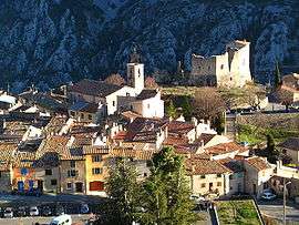
The church of Saint-Pierre in Gréolières, with the ruins of the former castle to the right | ||
| ||
 Gréolières | ||
|
Location within Provence-A.-C.d'A. region  Gréolières | ||
| Coordinates: 43°47′48″N 6°56′39″E / 43.7967°N 6.9442°ECoordinates: 43°47′48″N 6°56′39″E / 43.7967°N 6.9442°E | ||
| Country | France | |
| Region | Provence-Alpes-Côte d'Azur | |
| Department | Alpes-Maritimes | |
| Arrondissement | Grasse | |
| Canton | Coursegoules | |
| Government | ||
| • Mayor (2008–2014) | Marc Malfatto | |
| Area1 | 52.67 km2 (20.34 sq mi) | |
| Population (2008)2 | 540 | |
| • Density | 10/km2 (27/sq mi) | |
| Time zone | CET (UTC+1) | |
| • Summer (DST) | CEST (UTC+2) | |
| INSEE/Postal code | 06070 / 06620 | |
| Elevation |
492–1,778 m (1,614–5,833 ft) (avg. 810 m or 2,660 ft) | |
|
1 French Land Register data, which excludes lakes, ponds, glaciers > 1 km² (0.386 sq mi or 247 acres) and river estuaries. 2 Population without double counting: residents of multiple communes (e.g., students and military personnel) only counted once. | ||

Gréolières (Occitan: Greulieras) is a commune in the Alpes-Maritimes department in southeastern France.
Population
| Historical population | ||
|---|---|---|
| Year | Pop. | ±% |
| 1962 | 196 | — |
| 1968 | 250 | +27.6% |
| 1975 | 292 | +16.8% |
| 1982 | 311 | +6.5% |
| 1990 | 380 | +22.2% |
| 1999 | 455 | +19.7% |
| 2008 | 540 | +18.7% |
See also
References
External links
- The history and life of Gréolières Village in English
- Gréolières-les-Neiges - all about this great little ski resort, in English
| Wikimedia Commons has media related to Gréolières. |
This article is issued from Wikipedia - version of the 12/4/2016. The text is available under the Creative Commons Attribution/Share Alike but additional terms may apply for the media files.