Utelle
| Utelle | ||
|---|---|---|
|
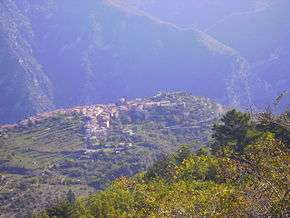
A view of Utelle from a nearby hillside | ||
| ||
 Utelle | ||
|
Location within Provence-A.-C.d'A. region  Utelle | ||
| Coordinates: 43°55′07″N 7°14′53″E / 43.9186°N 7.2481°ECoordinates: 43°55′07″N 7°14′53″E / 43.9186°N 7.2481°E | ||
| Country | France | |
| Region | Provence-Alpes-Côte d'Azur | |
| Department | Alpes-Maritimes | |
| Arrondissement | Nice | |
| Canton | Lantosque | |
| Government | ||
| • Mayor (2008–2014) | Bernard Cortes | |
| Area1 | 67.97 km2 (26.24 sq mi) | |
| Population (2008)2 | 693 | |
| • Density | 10/km2 (26/sq mi) | |
| Time zone | CET (UTC+1) | |
| • Summer (DST) | CEST (UTC+2) | |
| INSEE/Postal code | 06151 / 06450 | |
| Elevation |
126–2,080 m (413–6,824 ft) (avg. 800 m or 2,600 ft) | |
|
1 French Land Register data, which excludes lakes, ponds, glaciers > 1 km² (0.386 sq mi or 247 acres) and river estuaries. 2 Population without double counting: residents of multiple communes (e.g., students and military personnel) only counted once. | ||

Utelle (Occitan: Uels) is a commune about 40 miles (64 km) northeast of Nice in the Alpes-Maritimes department in southeastern France.
Geography
It is perched on a hill along the Vesubie Gorge not far from the Mercantour National Park.
Sights
Formerly an agricultural village planted with numerous olive trees, the village is near the Madonne d'Utelle, a chapel that serves as an annual pilgrimage site for local Catholics. In their 1997 book "The Templar Revelation," Lynn Picknett and Clive Prince mention (on pg. 82) "the old Templar town of Utelle, whose medieval houses still bear the esoteric sigils of the alchemists..."
Population
| Historical population | ||
|---|---|---|
| Year | Pop. | ±% |
| 1962 | 506 | — |
| 1968 | 516 | +2.0% |
| 1975 | 451 | −12.6% |
| 1982 | 398 | −11.8% |
| 1990 | 456 | +14.6% |
| 1999 | 488 | +7.0% |
| 2008 | 693 | +42.0% |
See also
Communes of the Alpes-Maritimes department
References
External links
- (English) (French) & (Occitan) Chimes from County of Nice : tirignoun (chime) from Utelle.
| Wikimedia Commons has media related to Utelle. |