Cipières
| Cipières | ||
|---|---|---|
|
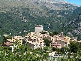
A general view of the village | ||
| ||
 Cipières | ||
|
Location within Provence-A.-C.d'A. region  Cipières | ||
| Coordinates: 43°47′03″N 6°57′21″E / 43.7842°N 6.9558°ECoordinates: 43°47′03″N 6°57′21″E / 43.7842°N 6.9558°E | ||
| Country | France | |
| Region | Provence-Alpes-Côte d'Azur | |
| Department | Alpes-Maritimes | |
| Arrondissement | Grasse | |
| Canton | Coursegoules | |
| Government | ||
| • Mayor (2008–2014) | Laurence Claisse | |
| Area1 | 38.15 km2 (14.73 sq mi) | |
| Population (2008)2 | 361 | |
| • Density | 9.5/km2 (25/sq mi) | |
| Time zone | CET (UTC+1) | |
| • Summer (DST) | CEST (UTC+2) | |
| INSEE/Postal code | 06041 / 06620 | |
| Elevation |
459–1,381 m (1,506–4,531 ft) (avg. 780 m or 2,560 ft) | |
|
1 French Land Register data, which excludes lakes, ponds, glaciers > 1 km² (0.386 sq mi or 247 acres) and river estuaries. 2 Population without double counting: residents of multiple communes (e.g., students and military personnel) only counted once. | ||
.svg.png)
Cipières (Occitan: Cipieras) is a commune in the Alpes-Maritimes department in southeastern France.
Cipieres is about 50 minutes drive from the French Riviera, and is an unspoilt medieval village of around 500 inhabitants. There are two restaurants, a pizzeria and a general store. Sheep are farmed on the surrounding mountain side and a farm sells lamb direct and also makes a renowned goats cheese. There is an annual free rock festival (Ciprock) as well as a homemade kart race through the narrow streets, attracting children as well as some more serious adults.
It enjoys a beautiful climate and has far reaching views across the valley of the wolf to the peak of Mount Cheiron, with the village of Greolieres in the foreground.
Population
| Historical population | ||
|---|---|---|
| Year | Pop. | ±% |
| 1962 | 128 | — |
| 1968 | 139 | +8.6% |
| 1975 | 131 | −5.8% |
| 1982 | 179 | +36.6% |
| 1990 | 222 | +24.0% |
| 1999 | 269 | +21.2% |
| 2008 | 361 | +34.2% |
See also
References
| Wikimedia Commons has media related to Cipières. |