Stockton, New Jersey
| Stockton, New Jersey | |
|---|---|
| Borough | |
| Borough of Stockton | |
 Map of Stockton in Hunterdon County. Inset: Location of Hunterdon County highlighted in the State of New Jersey. | |
 Census Bureau map of Stockton, New Jersey | |
| Coordinates: 40°24′20″N 74°58′27″W / 40.405431°N 74.974176°WCoordinates: 40°24′20″N 74°58′27″W / 40.405431°N 74.974176°W[1][2] | |
| Country |
|
| State |
|
| County | Hunterdon |
| Incorporated | April 14, 1898 |
| Government[3] | |
| • Type | Borough |
| • Body | Borough Council |
| • Mayor | Timothy J. Nemeth (D, term ends December 31, 2018)[4] |
| • Administrator / Clerk | Michele Hovan[5] |
| Area[1] | |
| • Total | 0.612 sq mi (1.584 km2) |
| • Land | 0.535 sq mi (1.386 km2) |
| • Water | 0.077 sq mi (0.198 km2) 12.52% |
| Elevation[6] | 121 ft (37 m) |
| Population (2010 Census)[7][8][9][10] | |
| • Total | 538 |
| • Estimate (2015)[11] | 524 |
| • Rank |
553rd of 566 in state 26th of 26 in county[12] |
| • Density | 1,005.6/sq mi (388.3/km2) |
| • Density rank |
381st of 566 in state 10th of 26 in county[12] |
| Time zone | Eastern (EST) (UTC-5) |
| • Summer (DST) | Eastern (EDT) (UTC-4) |
| ZIP code | 08559[13][14] |
| Area code(s) | 609 Exchanges: 397, 773[15] |
| FIPS code | 3401970980[1][16][17] |
| GNIS feature ID | 0885409[1][18] |
| Website |
www |
Stockton is a borough in Hunterdon County, New Jersey, United States. The borough sits on the Delaware River at the western end of Amwell Valley. As of the 2010 United States Census, the borough's population was 538,[7][8][9] reflecting a decline of 22 (-3.9%) from the 560 counted in the 2000 Census, which had in turn declined by 69 (-11.0%) from the 629 counted in the 1990 Census.[19]
Stockton was incorporated as a borough by an act of the New Jersey Legislature on April 14, 1898, from portions of Delaware Township.[20][21][22]
History
Stockton is located along the Delaware River north of Lambertville. The community was first known as Reading Ferry and later as Howell's Ferry. The name was changed to Centre Bridge Station to match the name of the post office and hamlet on the Pennsylvania side of the river. The name became Stockton with the creation of a local post office and railroad station in 1853. The town was named in honor of U.S. Senator Robert Field Stockton, who was instrumental in the creation of the Delaware and Raritan Canal.[23][24] Stockton soon began to develop as an an industrious town with mills and quarries sprouting in the area. In 1852 the Belvidere-Delaware Railroad reached town and accelerated its prosperity. The Borough was incorporated in 1898, having been separated from Delaware Township.[25]
Historic locations and sightseeing
The tiny town remains today much as it was in the eighteenth century. For all its small size and charm, the town is presided over by an old inn, the Stockton Inn (formerly known as Colligan's Stockton Inn). Established in 1710, it is the inn that was immortalized by Richard Rodgers in the song "There's a Small Hotel (with a wishing well)" sung in the Broadway play On Your Toes. First built as a private residence it is believed to have been converted to an inn around 1832. The Stockton Inn is now a historic restaurant with fireside dining in winter and garden dining in season. The Stockton Inn was acquired in June 2012 by Mitch Millett.[23]
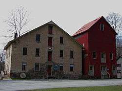
Prallsville Mills
The Delaware River Mill Society was formed to preserve and promote the buildings and site known as the Prallsville Mills. John Prall, Jr., became the owner of the site in 1794 and with his settlement the area became known as Prallsville.[26]
The Delaware River Mill Society is a private non-profit organization responsible for the restoration, maintenance, and operation of the historic John Prall Jr. House and the Prallsville Mills Complex, which was listed on the National Register of Historic Places in 1973. The entire property became part of the D & R Canal State Park in 1973. In 1976 when the State of New Jersey was unable to fund the restoration of its newly acquired Prallsville Mills, local citizens formed the Delaware River Mill Society, to "restore, preserve, operate, maintain and interpret" the historic site. The Mill Society's mission is to save a segment of our past and make it a part of today's community.
Prallsville Mills has become a place of cultural and environmental events attracting widespread participation. Visitors can tour 10 historic buildings including an 1877 grist mill, a 1790 linseed oil mill, an 1850 saw mill and a 1900 grain silo.[27] Concerts, art exhibitions, antique shows, holiday parties, school fund-raiser auctions, meetings, as well as private parties, are a source of income for restoration and maintenance of the site.[28] The site currently includes artist Ty Hodanish's studio and gallery, known as The Art Colony, which is housed in the Linseed Mill. The Mill is also situated in the center of the Delaware River Scenic Byway.[29]
Geography
According to the United States Census Bureau, the borough had a total area of 0.612 square miles (1.584 km2), including 0.535 square miles (1.386 km2) of land and 0.077 square miles (0.198 km2) of water (12.52%).[1][2]
The borough borders Delaware Township in Hunterdon County and Solebury Township in Bucks County, Pennsylvania.[30]
Prallsville is an unincorporated community located along the border with Delaware Township.
Demographics
| Historical population | |||
|---|---|---|---|
| Census | Pop. | %± | |
| 1900 | 590 | — | |
| 1910 | 605 | 2.5% | |
| 1920 | 519 | −14.2% | |
| 1930 | 556 | 7.1% | |
| 1940 | 478 | −14.0% | |
| 1950 | 488 | 2.1% | |
| 1960 | 520 | 6.6% | |
| 1970 | 619 | 19.0% | |
| 1980 | 643 | 3.9% | |
| 1990 | 629 | −2.2% | |
| 2000 | 560 | −11.0% | |
| 2010 | 538 | −3.9% | |
| Est. 2015 | 524 | [11][31] | −2.6% |
| Population sources: 1900-1920[32] 1900-1910[33] 1910-1930[34] 1930-1990[35] 2000[36][37] 2010[7][8][9] | |||
Census 2010
The 2010 United States Census counted 538 people, 237 households, and 142 families residing in the borough. The population density was 1,005.6 per square mile (388.3/km2). The borough contained 259 housing units at an average density of 484.1 per square mile (186.9/km2). The racial makeup of the borough was 98.33% (529) White, 0.00% (0) Black or African American, 0.00% (0) Native American, 0.93% (5) Asian, 0.00% (0) Pacific Islander, 0.00% (0) from other races, and 0.74% (4) from two or more races. Hispanics or Latinos of any race were 0.56% (3) of the population.[7]
Out of a total of 237 households, 23.2% had children under the age of 18 living with them, 48.5% were married couples living together, 7.2% had a female householder with no husband present, and 40.1% were non-families. 32.1% of all households were made up of individuals, and 11.8% had someone living alone who was 65 years of age or older. The average household size was 2.27 and the average family size was 2.94.[7]
In the borough, 19.5% of the population were under the age of 18, 5.9% from 18 to 24, 21.4% from 25 to 44, 35.1% from 45 to 64, and 18.0% who were 65 years of age or older. The median age was 47.7 years. For every 100 females the census counted 94.2 males, but for 100 females at least 18 years old, it was 96.8 males.[7]
The Census Bureau's 2006-2010 American Community Survey showed that (in 2010 inflation-adjusted dollars) median household income was $58,750 (with a margin of error of +/- $19,736) and the median family income was $72,321 (+/- $19,152). Males had a median income of $61,250 (+/- $24,259) versus $42,273 (+/- $34,015) for females. The per capita income for the borough was $38,153 (+/- $7,749). About 0.0% of families and 5.4% of the population were below the poverty line, including 0.0% of those under age 18 and 1.8% of those age 65 or over.[38]
Census 2000
As of the 2000 United States Census[16] there were 560 people, 246 households, and 148 families residing in the borough. The population density was 1,026.5 people per square mile (393.1/km2). There were 258 housing units at an average density of 472.9 per square mile (181.1/km2). The racial makeup of the borough was 98.57% White, 0.89% Asian, and 0.54% from two or more races. Hispanic or Latino of any race were 0.54% of the population.[36][37]
There were 246 households out of which 28.5% had children under the age of 18 living with them, 50.4% were married couples living together, 6.5% had a female householder with no husband present, and 39.8% were non-families. 30.5% of all households were made up of individuals and 11.0% had someone living alone who was 65 years of age or older. The average household size was 2.28 and the average family size was 2.94.[36][37]
In the borough the population was spread out with 21.3% under the age of 18, 4.3% from 18 to 24, 34.5% from 25 to 44, 25.2% from 45 to 64, and 14.8% who were 65 years of age or older. The median age was 41 years. For every 100 females there were 87.9 males. For every 100 females age 18 and over, there were 85.3 males.[36][37]
The median income for a household in the borough was $51,406, and the median income for a family was $65,000. Males had a median income of $42,083 versus $36,250 for females. The per capita income for the borough was $25,712. About 1.3% of families and 2.0% of the population were below the poverty line, including 1.7% of those under age 18 and 1.0% of those age 65 or over.[36][37]
Government
Local government
Stockton is governed under the Borough form of New Jersey municipal government. The governing body consists of a Mayor and a Borough Council comprising six council members, with all positions elected at-large on a partisan basis as part of the November general election. A Mayor is elected directly by the voters to a four-year term of office. The Borough Council consists of six members elected to serve three-year terms on a staggered basis, with two seats coming up for election each year in a three-year cycle.[3] The Borough form of government used by Stockton, the most common system used in the state, is a "weak mayor / strong council" government in which council members act as the legislative body with the mayor presiding at meetings and voting only in the event of a tie. The mayor can veto ordinances subject to an override by a two-thirds majority vote of the council. The mayor makes committee and liaison assignments for council members, and most appointments are made by the mayor with the advice and consent of the council.[39][40]
As of 2016, the Mayor of Stockton Borough is Democrat Timothy J. Nemeth, whose term of office ends December 31, 2018. Members of the Borough Council are Deputy Mayor Nic Messina (R, 2018), Anthony A. Grecco (R, 2016; elected to serve an unexpired term), Adam Juncosa (D, 2017; elected to serve an unexpired term), Aaron Lipsen (D, 2018), Kathryn "Kate" Steffanelli (D, 2017) and Donald Vandegrift (R, 2016).[25][41][42][43][44][45][46]
Democrat Neal Esposito died in office on October 23, 2014, and was reelected posthumously for a new three-year term in the November general election. In the same election, Timothy Nemeth was elected as mayor, creating a vacancy in his seat expiring in December 2016.[47] Democrat Adam Juncosa and Republican Anthony A. Grecco were appointed to fill the council vacancies.[48] In the November 2015 general election, both Juncosa and Grecco were elected to serve the balance of the terms of office.[44]
Federal, state and county representation
Stockton is located in the 7th Congressional District[49] and is part of New Jersey's 16th state legislative district.[8][50][51] Prior to the 2011 reapportionment following the 2010 Census, Stockton had been in the 23rd state legislative district.[52] Prior to the 2010 Census, Stockton had been part of the 12th Congressional District, a change made by the New Jersey Redistricting Commission that took effect in January 2013, based on the results of the November 2012 general elections.[52]
New Jersey's Seventh Congressional District is represented by Leonard Lance (R, Clinton Township).[53] New Jersey is represented in the United States Senate by Cory Booker (D, Newark, term ends 2021)[54] and Bob Menendez (D, Paramus, 2019).[55][56]
For the 2016–2017 session (Senate, General Assembly), the 16th Legislative District of the New Jersey Legislature is represented in the State Senate by Christopher Bateman (R, Branchburg) and in the General Assembly by Jack Ciattarelli (R, Hillsborough Township) and Andrew Zwicker (D, South Brunswick). [57] The Governor of New Jersey is Chris Christie (R, Mendham Township).[58] The Lieutenant Governor of New Jersey is Kim Guadagno (R, Monmouth Beach).[59]
Hunterdon County is governed by a five-member Board of Chosen Freeholders, who serve three-year terms of office at-large on a staggered basis, with either one or two seats up for election each year on a partisan basis as part of the November general election. At an annual reorganization meeting held each January, the freeholders select one member to serve as the board's Director and another to serve as Deputy Director.[60] As of 2015, Hunterdon County's Freeholders are Freeholder Director John King (R; Raritan Township, 2015),[61] Freeholder Deputy Director Suzanne Lagay (R; Holland Township, 2016),[62] J. Matthew Holt (R; Clinton Town, 2015),[63] John E. Lanza (R; Flemington, 2016)[64] and Robert G. Walton (R; Hampton, 2017).[65][66] Constitutional officers elected on a countywide basis are County Clerk Mary H. Melfi (R; Flemington, 2017),[67] Sheriff Fredrick W. Brown (R; Alexandria Township, 2016)[68] and Surrogate Susan J. Hoffman (R; Kingwood Township, 2018).[69][70][71]
Politics
As of March 23, 2011, there were a total of 396 registered voters in Stockton, of which 166 (41.9%) were registered as Democrats, 127 (32.1%) were registered as Republicans and 102 (25.8%) were registered as Unaffiliated. There was one voter registered to another party.[72]
In the 2012 presidential election, Democrat Barack Obama received 58.2% of the vote (174 cast), ahead of Republican Mitt Romney with 40.1% (120 votes), and other candidates with 1.7% (5 votes), among the 300 ballots cast by the borough's 399 registered voters (1 ballot was spoiled), for a turnout of 75.2%.[73][74] In the 2008 presidential election, Democrat Barack Obama received 59.3% of the vote (210 cast), ahead of Republican John McCain with 38.1% (135 votes) and other candidates with 1.4% (5 votes), among the 354 ballots cast by the borough's 405 registered voters, for a turnout of 87.4%.[75] In the 2004 presidential election, Democrat John Kerry received 57.3% of the vote (200 ballots cast), outpolling Republican George W. Bush with 41.5% (145 votes) and other candidates with 1.0% (4 votes), among the 349 ballots cast by the borough's 412 registered voters, for a turnout percentage of 84.7.[76]
In the 2013 gubernatorial election, Republican Chris Christie received 60.1% of the vote (131 cast), ahead of Democrat Barbara Buono with 37.2% (81 votes), and other candidates with 2.8% (6 votes), among the 221 ballots cast by the borough's 393 registered voters (3 ballots were spoiled), for a turnout of 56.2%.[77][78] In the 2009 gubernatorial election, Republican Chris Christie received 45.7% of the vote (122 ballots cast), ahead of Democrat Jon Corzine with 43.4% (116 votes), Independent Chris Daggett with 8.2% (22 votes) and other candidates with 1.9% (5 votes), among the 267 ballots cast by the borough's 398 registered voters, yielding a 67.1% turnout.[79]
Education
The South Hunterdon Regional School District serves students in pre-Kindergarten through twelfth grade from Lambertville, Stockton and West Amwell Township.[80] Public school students in seventh through twelfth grades attend the South Hunterdon Regional High School in Lambertville, which served 402 students in the 2012-13 school year.[81][82]
In a special election held in September 2013, voters from Lambertville, Stockton and West Amwell Township passed referenda to dissolve the South Hunterdon Regional School District and to combine the three existing school districts from each municipality (Lambertville City School District, Stockton Borough School District and West Amwell Township School District), with majorities in each community passing both ballot items. A single combined regional district would be created, serving students in grades K-12, in which property taxes would be levied under a formula in which 57% is based on property values and 43% on the number of students. The executive county superintendent will appoint an interim board of education for the new regional district, which will be responsible for implementing the merger.[83]
Transportation
As of May 2010, the borough had a total of 4.09 miles (6.58 km) of roadways, of which 2.50 miles (4.02 km) were maintained by the municipality, 0.28 miles (0.45 km) by Hunterdon County and 1.31 miles (2.11 km) by the New Jersey Department of Transportation.[84]
The Centre Bridge-Stockton Bridge, a free bridge over the Delaware River, owned and operated by the Delaware River Joint Toll Bridge Commission, connects Pennsylvania Route 32 and Pennsylvania Route 263 in Solebury Township, Pennsylvania to Route 29 in Stockton. The original bridge, constructed at the site formerly known as Reading's Ferry, was opened to traffic in the spring of 1814. The covered bridge was destroyed in a flood on January 8, 1841, striking the Lambertville Bridge on its way down the Delaware, as part of a flood that severely damaged every bridge between Easton, Pennsylvania and Trenton.[21]
Notable people
People who were born in, residents of, or otherwise closely associated with Stockton include:
- Anne Elstner (1899-1981), actress who played the title role on the radio soap opera Stella Dallas during its entire run, from 1937-1955.[85]
- Chet Huntley (1911-1974), television newscaster, best known for co-anchoring NBC's evening news program, the Huntley-Brinkley Report, for 14 years beginning in 1956.[86]
- JP Miller (1919–2001), writer of teleplays during the Golden Age of Television.[87]
- Carolyn Rovee-Collier (1942-2014), pioneer and expert in cognitive development.[88]
References
- 1 2 3 4 5 2010 Census Gazetteer Files: New Jersey County Subdivisions, United States Census Bureau. Accessed May 21, 2015.
- 1 2 US Gazetteer files: 2010, 2000, and 1990, United States Census Bureau. Accessed September 4, 2014.
- 1 2 2012 New Jersey Legislative District Data Book, Rutgers University Edward J. Bloustein School of Planning and Public Policy, March 2013, p. 103.
- ↑ 2016 New Jersey Mayors Directory, New Jersey Department of Community Affairs. Accessed June 14, 2016. As of date accessed, Nemeth is listed as mayor with an incorrect term-end year of 2020.
- ↑ Administration/Clerk, Stockton Borough. Accessed July 10, 2016.
- ↑ U.S. Geological Survey Geographic Names Information System: Borough of Stockton, Geographic Names Information System. Accessed March 14, 2013.
- 1 2 3 4 5 6 DP-1 - Profile of General Population and Housing Characteristics: 2010 Demographic Profile Data for Stockton borough, Hunterdon County, New Jersey, United States Census Bureau. Accessed May 22, 2012.
- 1 2 3 4 Municipalities Grouped by 2011-2020 Legislative Districts, New Jersey Department of State, p. 8. Accessed January 6, 2013.
- 1 2 3 Table DP-1. Profile of General Demographic Characteristics: 2010 for Stockton borough, New Jersey Department of Labor and Workforce Development. Accessed May 22, 2012.
- ↑ Staff. "N.J.'s population shifting to coast, south; Densely settled areas near New York City stagnated or declined, while areas outside Philadelphia and in coastal and southern sections gained.", USA Today, February 27, 2011. Accessed October 28, 2014.
- 1 2 PEPANNRES - Annual Estimates of the Resident Population: April 1, 2010 to July 1, 2015 - 2015 Population Estimates for New Jersey municipalities, United States Census Bureau. Accessed May 22, 2016.
- 1 2 GCT-PH1 Population, Housing Units, Area, and Density: 2010 - State -- County Subdivision from the 2010 Census Summary File 1 for New Jersey, United States Census Bureau. Accessed November 15, 2012.
- ↑ Look Up a ZIP Code for Stockton, NJ, United States Postal Service. Accessed May 23, 2012.
- ↑ Zip Codes, State of New Jersey. Accessed August 30, 2013.
- ↑ Area Code Lookup - NPA NXX for Stockton, NJ, Area-Codes.com. Accessed August 30, 2013.
- 1 2 American FactFinder, United States Census Bureau. Accessed September 4, 2014.
- ↑ A Cure for the Common Codes: New Jersey, Missouri Census Data Center. Accessed May 23, 2012.
- ↑ US Board on Geographic Names, United States Geological Survey. Accessed September 4, 2014.
- ↑ Table 7. Population for the Counties and Municipalities in New Jersey: 1990, 2000 and 2010, New Jersey Department of Labor and Workforce Development, February 2011. Accessed November 15, 2012.
- ↑ Snyder, John P. The Story of New Jersey's Civil Boundaries: 1606-1968, Bureau of Geology and Topography; Trenton, New Jersey; 1969. p. 157. Accessed May 23, 2012.
- 1 2 Stockton Borough History, Hunterdon County, New Jersey. Accessed May 23, 2012.
- ↑ Honeyman, Abraham Van Doren. Index-analysis of the Statutes of New Jersey, 1896-1909: Together with References to All Acts, and Parts of Acts, in the 'General Statutes' and Pamphlet Laws Expressly Repealed: and the Statutory Crimes of New Jersey During the Same Period, p. 270. New Jersey Law Journal Publishing Company, 1910. Accessed October 10, 2015.
- 1 2 Stockton Borough History, Hunterdon County, New Jersey. Accessed October 10, 2015. "In 1853 a new post office was built near the bridge and the town was named Stockton in honor of Senator Robert Field Stockton who helped to make the canal a reality, with which helped the new community to thrive."
- ↑ Hutchinson, Viola L. The Origin of New Jersey Place Names, New Jersey Public Library Commission, May 1945. Accessed October 10, 2015.
- 1 2 Borough of Stockton, Hunterdon County, New Jersey. Accessed July 7, 2016.
- ↑ Buck's County Herald Area Guidebook, accessed November 11, 2007
- ↑ "Official site". Prallsville Mills. Retrieved 9 November 2015.
- ↑ History, Delaware River Mill Society. Accessed August 30, 2013.
- ↑ Stockton, New Jersey Tourism. Accessed August 30, 2013.
- ↑ Areas touching Stockton, MapIt. Accessed October 10, 2015.
- ↑ Census Estimates for New Jersey April 1, 2010 to July 1, 2015, United States Census Bureau. Accessed May 22, 2016.
- ↑ Compendium of censuses 1726-1905: together with the tabulated returns of 1905, New Jersey Department of State, 1906. Accessed August 30, 2013.
- ↑ Thirteenth Census of the United States, 1910: Population by Counties and Minor Civil Divisions, 1910, 1900, 1890, United States Census Bureau, p. 337. Accessed May 23, 2012. Population is not listed for 1900.
- ↑ Fifteenth Census of the United States : 1930 - Population Volume I, United States Census Bureau, p. 716. Accessed May 23, 2012.
- ↑ Table 6. New Jersey Resident Population by Municipality: 1930 - 1990, New Jersey Department of Labor and Workforce Development. Accessed June 28, 2015.
- 1 2 3 4 5 Census 2000 Profiles of Demographic / Social / Economic / Housing Characteristics for Stockton borough, New Jersey, United States Census Bureau. Accessed November 15, 2012.
- 1 2 3 4 5 DP-1: Profile of General Demographic Characteristics: 2000 - Census 2000 Summary File 1 (SF 1) 100-Percent Data for Stockton borough, Hunterdon County, New Jersey, United States Census Bureau. Accessed November 15, 2012.
- ↑ DP03: Selected Economic Characteristics from the 2006-2010 American Community Survey 5-Year Estimates for Stockton borough, Hunterdon County, New Jersey, United States Census Bureau. Accessed May 23, 2012.
- ↑ Cerra, Michael F. "Forms of Government: Everything You've Always Wanted to Know, But Were Afraid to Ask", New Jersey State League of Municipalities. Accessed November 30, 2014.
- ↑ "Forms of Municipal Government in New Jersey", p. 6. Rutgers University Center for Government Studies. Accessed June 3, 2015.
- ↑ Home Page, Borough of Stockton. Accessed July 10, 2016.
- ↑ 2015 Municipal Data Sheet, Borough of Stockton. Accessed November 15, 2015.
- ↑ 2016 County and Municipal Directory, Hunterdon County, New Jersey. Accessed July 7, 2016.
- 1 2 Hunterdon County District Canvass November 3, 2015, Hunterdon County, New Jersey, updated November 5, 2015. Accessed July 7, 2016.
- ↑ Hunterdon County Statement of Vote November 4, 2014, Hunterdon County, New Jersey, updated November 6, 2014. Accessed July 7, 2016.
- ↑ Hunterdon County Statement of Vote November 5, 2013, Hunterdon County, New Jersey, updated November 12, 2013. Accessed July 7, 2016.
- ↑ Staff. 'Hunterdon County election results 2014", Hunterdon County Democrat, November 4, 2014. Accessed April 15, 2015.
- ↑ Wright, Terry. "2015 elections: Hunterdon Republicans and Democrats file for the primary", Hunterdon County Democrat, March 31, 2015. Accessed April 15, 2015. "Stockton Borough Council, 1-year unexpired term: Democrat incumbent Adam Juncosa filed but not any Republicans. 2-year unexpired term, another incumbent, Republican Anthony A. Grecco, put in a nomination while no Democrats did."
- ↑ Plan Components Report, New Jersey Redistricting Commission, December 23, 2011. Accessed January 6, 2013.
- ↑ 2016 New Jersey Citizen's Guide to Government, p. 64, New Jersey League of Women Voters. Accessed July 20, 2016.
- ↑ Districts by Number for 2011-2020, New Jersey Legislature. Accessed January 6, 2013.
- 1 2 2011 New Jersey Citizen's Guide to Government, p. 65, New Jersey League of Women Voters. Accessed May 22, 2015.
- ↑ Directory of Representatives: New Jersey, United States House of Representatives. Accessed January 5, 2012.
- ↑ About Cory Booker, United States Senate. Accessed January 26, 2015. "He now owns a home and lives in Newark's Central Ward community."
- ↑ Biography of Bob Menendez, United States Senate, January 26, 2015. "He currently lives in Paramus and has two children, Alicia and Robert."
- ↑ Senators of the 114th Congress from New Jersey. United States Senate. Accessed January 26, 2015. "Booker, Cory A. - (D - NJ) Class II; Menendez, Robert - (D - NJ) Class I"
- ↑ Legislative Roster 2016-2017 Session, New Jersey Legislature. Accessed January 17, 2016.
- ↑ "About the Governor". State of New Jersey. Retrieved 2010-01-21.
- ↑ "About the Lieutenant Governor". State of New Jersey. Retrieved 2010-01-21.
- ↑ About the Board, Hunterdon County, New Jersey. Accessed January 8, 2015.
- ↑ John King, Hunterdon County, New Jersey. Accessed January 8, 2015.
- ↑ Suzanne Lagay, Hunterdon County, New Jersey. Accessed January 8, 2015.
- ↑ J. Matthew Holt, Hunterdon County, New Jersey. Accessed January 8, 2015.
- ↑ John E. Lanza, Hunterdon County, New Jersey. Accessed January 8, 2015.
- ↑ Robert G. Walton, Hunterdon County, New Jersey. Accessed January 8, 2015.
- ↑ Hunterdon County Board of Chosen Freeholders, Hunterdon County, New Jersey. Accessed January 8, 2015.
- ↑ Hunterdon County Clerk Mary H. Melfi, Hunterdon County, New Jersey. Accessed January 8, 2015.
- ↑ Frederick W. Brown; Hunterdon County Sheriff, Hunterdon County, New Jersey. Accessed January 8, 2015.
- ↑ Surrogate Susan J. Hoffman, Hunterdon County, New Jersey. Accessed January 8, 2015.
- ↑ 2014 Elected Officials, Hunterdon County, New Jersey. Accessed January 8, 2015.
- ↑ 2014 County and Municipal Guide ... Hunterdon County Now, Hunterdon County, New Jersey. Accessed January 8, 2015.
- ↑ Voter Registration Summary - Hunterdon, New Jersey Department of State Division of Elections, March 23, 2011. Accessed November 15, 2012.
- ↑ "Presidential General Election Results - November 6, 2012 - Hunterdon County" (PDF). New Jersey Department of Elections. March 15, 2013. Retrieved December 24, 2014.
- ↑ "Number of Registered Voters and Ballots Cast - November 6, 2012 - General Election Results - Hunterdon County" (PDF). New Jersey Department of Elections. March 15, 2013. Retrieved December 24, 2014.
- ↑ 2008 Presidential General Election Results: Hunterdon County, New Jersey Department of State Division of Elections, December 23, 2008. Accessed November 15, 2012.
- ↑ 2004 Presidential Election: Hunterdon County, New Jersey Department of State Division of Elections, December 13, 2004. Accessed November 15, 2012.
- ↑ "Governor - Hunterdon County" (PDF). New Jersey Department of Elections. January 29, 2014. Retrieved December 24, 2014.
- ↑ "Number of Registered Voters and Ballots Cast - November 5, 2013 - General Election Results - Hunterdon County" (PDF). New Jersey Department of Elections. January 29, 2014. Retrieved December 24, 2014.
- ↑ 2009 Governor: Hunterdon County, New Jersey Department of State Division of Elections, December 31, 2009. Accessed November 15, 2012.
- ↑ South Hunterdon Regional School District 2015 Report Card Narrative, New Jersey Department of Education. Accessed June 2, 2016. "Bordering the Delaware River and located in the culturally rich and rural region of Southern Hunterdon County, South Hunterdon Regional School District serves the communities of Lambertville, Stockton, and West Amwell."
- ↑ School Data for the South Hunterdon Regional High School District, National Center for Education Statistics. Accessed April 15, 2015.
- ↑ Public School Directory 2014-2015, Hunterdon County Department of Education. Accessed April 15, 2015.
- ↑ Tredrea, John. "LAMBERTVILLE: Schools turn how to make merger work; After historic vote, decisions on buildings, contracts need to be made", The Beacon, October 2, 2013. Accessed April 15, 2015. "Now that the two referendum questions on merging the Stockton, West Amwell, Lambertville and South Hunterdon Regional High School districts into one pre-k to grade 12 district have been overwhelmingly approved, the process of implementing the regionalization can begin."
- ↑ Hunterdon County Mileage by Municipality and Jurisdiction, New Jersey Department of Transportation, May 2010. Accessed July 18, 2014.
- ↑ Staff. "ANNE E. MATTHEWS, 85, ACTRESS; PORTRAYED STELLA DALLAS ON RADIO", The New York Times, January 16, 1981. Accessed November 2, 2015. "Anne Elstner Matthews, who played Stella Dallas on the long-running radio serial of that name, died of a stroke in Doylestown, Pa., on Jan. 29. Mrs. Matthews, who had lived for many years in Stockton, N.J., was 82 years old."
- ↑ Gould, Jack. "HUNTLEY ENDS USE OF NAME ON MEAT", The New York Times, March 31, 1964. Accessed June 5, 2015. "Mr. Huntley, concurring in the N.B.C. announcement, said that cattle fed at his farm in Stockton, N. J., would be sold in the open market and would not carry his name for promotion purposes."
- ↑ J. P. Miller, James A. Michener Art Museum. Accessed November 15, 2012. "At the time of his death, Miller was at work on an autobiography at his home in Stockton, New Jersey, where he lived since 1965."
- ↑ Vitello, Paul. "Carolyn Rovee-Collier, Who Said Babies Have Clear Memories, Is Dead at 72", The New York Times, October 22, 2014. Accessed October 28, 2014. "She taught at Trenton State College before joining Rutgers in 1970 and lived in Stockton, N.J."
External links
- Official website
- Hunterdon County web page for Stockton Borough
- Stockton Borough Elementary School
- Stockton Borough Elementary School's 2014–15 School Report Card from the New Jersey Department of Education
- School Data for the Stockton Borough Elementary School, National Center for Education Statistics
- Centre Bridge-Stockton article at the Delaware River Joint Toll Bridge Commission website
- An article about Stockton Borough's history at the Hunterdon County website
- Delaware River Mill Society's webpage for the Prallsville Mills complex
- Hunterdon Land Trust Alliance
| Wikimedia Commons has media related to Stockton, New Jersey. |
