Lansdowne, New Jersey
| Lansdowne, New Jersey | |
|---|---|
| Unincorporated community | |
|
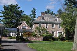
Historic house in Lansdowne | |
 Lansdowne, New Jersey  Lansdowne, New Jersey  Lansdowne, New Jersey Location of Lansdowne in Hunterdon County Inset: Location of county within the state of New Jersey | |
| Coordinates: 40°36′30″N 74°54′23″W / 40.60833°N 74.90639°WCoordinates: 40°36′30″N 74°54′23″W / 40.60833°N 74.90639°W | |
| Country |
|
| State |
|
| County | Hunterdon |
| Township | Franklin |
| Elevation[1] | 167 ft (51 m) |
| GNIS feature ID | 877671[1] |
|
Lansdown Historic District | |
| NRHP Reference # | 79001497[2] |
|---|---|
| Added to NRHP | November 2, 1979 |
Lansdowne, Landsdown or Landsdowne is an unincorporated community located within Franklin Township in Hunterdon County, New Jersey, United States.[3][4]
References
- 1 2 "Lansdowne". Geographic Names Information System. United States Geological Survey.
- ↑ National Park Service (2009-03-13). "National Register Information System". National Register of Historic Places. National Park Service.
- ↑ Locality Search, State of New Jersey. Accessed January 30, 2015.
- ↑ Google (January 30, 2015). "Lansdowne, New Jersey" (Map). Google Maps. Google. Retrieved January 30, 2015.

| Topics | 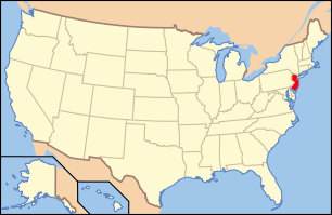 | ||
|---|---|---|---|
| Lists by county | |||
| Lists by city |
| ||
| Other lists | |||
| |||
This article is issued from Wikipedia - version of the 6/8/2016. The text is available under the Creative Commons Attribution/Share Alike but additional terms may apply for the media files.