Delaware Township, Hunterdon County, New Jersey
| Delaware Township, New Jersey | |
|---|---|
| Township | |
| Township of Delaware | |
|
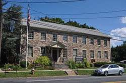
Township municipal building in Sergeantsville | |
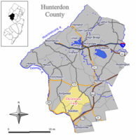 Map of Delaware Township in Hunterdon County. Inset: Location of Hunterdon County highlighted in the State of New Jersey. | |
 Census Bureau map of Delaware Township, Hunterdon County, New Jersey | |
| Coordinates: 40°26′30″N 74°57′29″W / 40.441616°N 74.957987°WCoordinates: 40°26′30″N 74°57′29″W / 40.441616°N 74.957987°W[1][2] | |
| Country |
|
| State |
|
| County | Hunterdon |
| Incorporated | April 2, 1838 |
| Named for | Delaware River |
| Government[3] | |
| • Type | Township |
| • Body | Township Committee |
| • Mayor | Susan D. Lockwood (D, term ends December 31, 2016)[4][4][5] |
| • Clerk | Jodi McKinney[6] |
| Area[1] | |
| • Total | 37.022 sq mi (95.887 km2) |
| • Land | 36.637 sq mi (94.889 km2) |
| • Water | 0.385 sq mi (0.997 km2) 1.04% |
| Area rank |
65th of 566 in state 3rd of 26 in county[1] |
| Elevation[7] | 371 ft (113 m) |
| Population (2010 Census)[8][9][10] | |
| • Total | 4,563 |
| • Estimate (2015)[11] | 4,491 |
| • Rank |
394th of 566 in state 10th of 26 in county[12] |
| • Density | 124.5/sq mi (48.1/km2) |
| • Density rank |
532nd of 566 in state 25th of 26 in county[12] |
| Time zone | Eastern (EST) (UTC-5) |
| • Summer (DST) | Eastern (EDT) (UTC-4) |
| ZIP codes |
08822 - Flemington[13] 08557 - Sergeantsville[14] 08559 - Stockton[15] |
| Area code(s) | 609, 908[16] |
| FIPS code | 3401917170[1][17][18] |
| GNIS feature ID | 0882182[1][19] |
| Website |
www |
Delaware Township is a township in Hunterdon County, New Jersey, United States. Part of the township is on the Hunterdon Plateau, while the southern portions are in the Amwell Valley. As of the 2010 United States Census, the township's population was 4,563,[8][9][10] reflecting an increase of 85 (+1.9%) from the 4,478 counted in the 2000 Census, which had in turn declined by 34 (-0.8%) from the 4,512 counted in the 1990 Census.[20]
The historic community of Sergeantsville is located within Delaware Township, as well as the unincorporated community of Raven Rock.
History
The township was first settled in the early 18th century by Colonel John Reading (1657–1717), who was instrumental in the creation of Amwell Township in 1708 and also worked for the creation of Hunterdon County in 1714. The Township adjoins the Delaware River on the southwestern portion of Hunterdon County, which provides its name.[21] The state's lone surviving historic covered bridge crosses the Wickecheoke Creek between Sergeantsville and Rosemont. The Delaware and Raritan Canal parallels the Delaware River along the southern border of the township. Sergeantsville is at the township's center and includes the municipal building, local public school and Post Office. A "Thanksgiving in the Country" offers a tour of notable homes in Sergeantsville, which raises funds for the Facial Reconstruction Unit of the Children's Hospital of Philadelphia.[22]
Delaware was incorporated as a township by an act of the New Jersey Legislature on April 2, 1838, from a portion of a larger municipality then known as Amwell Township (now defunct).[23] Historian and cartographer John P. Snyder has erroneously stated that a referendum was held on that date, but there was in fact no referendum and the people of Amwell knew nothing about the division until after the Legislature passed the bill.[24] A portion of the township was taken to form Stockton borough (April 14, 1898).[23]
Geography
According to the United States Census Bureau, the township had a total area of 37.022 square miles (95.887 km2), including 36.637 square miles (94.889 km2) of land and 0.385 square miles (0.997 km2) of water (1.04%).[1][2]
Unincorporated communities, localities and place names located partially or completely within the township include Bowne, Brookville, Dilts Corner, Grover, Headquarters, Locktown, Prallsville, Raven Rock, Rosemont, Sand Brook, Sandy Ridge and Sergeantsville.[25]
Demographics
| Historical population | |||
|---|---|---|---|
| Census | Pop. | %± | |
| 1840 | 2,305 | — | |
| 1850 | 2,554 | 10.8% | |
| 1860 | 2,838 | 11.1% | |
| 1870 | 2,959 | 4.3% | |
| 1880 | 3,092 | 4.5% | |
| 1890 | 3,037 | −1.8% | |
| 1900 | 1,953 | * | −35.7% |
| 1910 | 1,740 | −10.9% | |
| 1920 | 1,705 | −2.0% | |
| 1930 | 1,704 | −0.1% | |
| 1940 | 1,756 | 3.1% | |
| 1950 | 2,031 | 15.7% | |
| 1960 | 2,485 | 22.4% | |
| 1970 | 3,249 | 30.7% | |
| 1980 | 3,816 | 17.5% | |
| 1990 | 4,512 | 18.2% | |
| 2000 | 4,478 | −0.8% | |
| 2010 | 4,563 | 1.9% | |
| Est. 2015 | 4,491 | [11][26] | −1.6% |
| Population sources: 1840-1920[27] 1840[28] 1850-1870[29] 1850[30] 1870[31] 1880-1890[32] 1890-1910[33] 1910-1930[34] 1930-1990[35] 2000[36][37] 2010[8][9][10] * = Lost territory in previous decade.[23] | |||
Census 2010
At the 2010 United States Census, there were 4,563 people, 1,788 households, and 1,348 families residing in the township. The population density was 124.5 per square mile (48.1/km2). There were 1,927 housing units at an average density of 52.6 per square mile (20.3/km2). The racial makeup of the township was 96.45% (4,401) White, 0.66% (30) Black or African American, 0.18% (8) Native American, 0.92% (42) Asian, 0.00% (0) Pacific Islander, 0.50% (23) from other races, and 1.29% (59) from two or more races. Hispanics or Latinos of any race were 2.45% (112) of the population.[8]
There were 1,788 households, of which 26.6% had children under the age of 18 living with them, 66.2% were married couples living together, 6.3% had a female householder with no husband present, and 24.6% were non-families. 19.0% of all households were made up of individuals, and 7.7% had someone living alone who was 65 years of age or older. The average household size was 2.55 and the average family size was 2.93.[8]
In the township, 20.1% of the population were under the age of 18, 6.1% from 18 to 24, 16.5% from 25 to 44, 41.2% from 45 to 64, and 16.1% who were 65 years of age or older. The median age was 48.6 years. For every 100 females there were 96.9 males. For every 100 females age 18 and over, there were 97.2 males.[8]
The Census Bureau's 2006-2010 American Community Survey showed that (in 2010 inflation-adjusted dollars) median household income was $87,100 (with a margin of error of +/- $15,616) and the median family income was $102,481 (+/- $27,024). Males had a median income of $82,586 (+/- $14,105) versus $47,404 (+/- $12,866) for females. The per capita income for the borough was $48,700 (+/- $4,857). About 0.6% of families and 0.6% of the population were below the poverty line, including 0.0% of those under age 18 and 0.9% of those age 65 or over.[38]
Census 2000
As of the 2000 United States Census[17] there were 4,478 people, 1,643 households, and 1,302 families residing in the township. The population density was 121.9 people per square mile (47.1/km²). There were 1,701 housing units at an average density of 46.3 per square mile (17.9/km²). The racial makeup of the township was 97.70% White, 0.40% African American, 0.04% Native American, 1.03% Asian, 0.02% Pacific Islander, 0.25% from other races, and 0.56% from two or more races. Hispanic or Latino of any race were 1.14% of the population.[36][37]
There were 1,643 households out of which 33.8% had children under the age of 18 living with them, 71.3% were married couples living together, 4.9% had a female householder with no husband present, and 20.7% were non-families. 14.8% of all households were made up of individuals and 6.0% had someone living alone who was 65 years of age or older. The average household size was 2.72 and the average family size was 3.06.[36][37]
In the township the population was spread out with 23.4% under the age of 18, 5.9% from 18 to 24, 26.5% from 25 to 44, 32.3% from 45 to 64, and 11.8% who were 65 years of age or older. The median age was 42 years. For every 100 females there were 98.8 males. For every 100 females age 18 and over, there were 100.3 males.[36][37]
The median income for a household in the township was $80,756, and the median income for a family was $90,842. Males had a median income of $61,701 versus $48,780 for females. The per capita income for the township was $38,285. 3.4% of the population and 2.3% of families were below the poverty line. Out of the total people living in poverty, 1.2% are under the age of 18 and 12.2% are 65 or older.[36][37]
Government
Local government
Delaware Township is governed under the Township form of government. The five-member Township Committee is elected directly by the voters at-large in partisan elections to serve three-year terms of office on a staggered basis, with either one or two seats coming up for election each year as part of the November general election in a three-year cycle.[3][39] At an annual reorganization meeting, the Township Committee selects one of its members to serve as Mayor and another as Deputy Mayor.
As of 2016, members of the Delaware Township Committee are Mayor Susan D. Lockwood (D, term on committee ends December 31, 2017; term as mayor ends 2016), Deputy Mayor Charles Herman (R, term on committee ends 2017; term as deputy mayor ends 2016), Alan C. Johnson (R, 2018), Samuel Thompson (D, 2018) and Joseph Vocke (R, 2016).[4][22][40][41][42][43][44]
Federal, state and county representation
Delaware Township is located in the 7th Congressional District[45] and is part of New Jersey's 16th state legislative district.[9][46][47] Prior to the 2011 reapportionment following the 2010 Census, Delaware Township had been in the 23rd state legislative district.[48] Prior to the 2010 Census, Delaware Township had been part of the 12th Congressional District, a change made by the New Jersey Redistricting Commission that took effect in January 2013, based on the results of the November 2012 general elections.[48]
New Jersey's Seventh Congressional District is represented by Leonard Lance (R, Clinton Township).[49] New Jersey is represented in the United States Senate by Cory Booker (D, Newark, term ends 2021)[50] and Bob Menendez (D, Paramus, 2019).[51][52]
For the 2016–2017 session (Senate, General Assembly), the 16th Legislative District of the New Jersey Legislature is represented in the State Senate by Christopher Bateman (R, Somerville) and in the General Assembly by Jack Ciattarelli (R, Hillsborough Township) and Andrew Zwicker (D, South Brunswick). [53] The Governor of New Jersey is Chris Christie (R, Mendham Township).[54] The Lieutenant Governor of New Jersey is Kim Guadagno (R, Monmouth Beach).[55]
Hunterdon County is governed by a five-member Board of Chosen Freeholders, who serve three-year terms of office at-large on a staggered basis, with either one or two seats up for election each year on a partisan basis as part of the November general election. At an annual reorganization meeting held each January, the freeholders select one member to serve as the board's Director and another to serve as Deputy Director.[56] As of 2015, Hunterdon County's Freeholders are Freeholder Director John King (R; Raritan Township, 2015),[57] Freeholder Deputy Director Suzanne Lagay (R; Holland Township, 2016),[58] J. Matthew Holt (R; Clinton Town, 2015),[59] John E. Lanza (R; Flemington, 2016)[60] and Robert G. Walton (R; Hampton, 2017).[61][62] Constitutional officers elected on a countywide basis are County Clerk Mary H. Melfi (R; Flemington, 2017),[63] Sheriff Fredrick W. Brown (R; Alexandria Township, 2016)[64] and Surrogate Susan J. Hoffman (R; Kingwood Township, 2018).[65][66][67]
Politics
As of March 23, 2011, there were a total of 3,558 registered voters in Delaware Township, of which 811 (22.8%) were registered as Democrats, 1,512 (42.5%) were registered as Republicans and 1,232 (34.6%) were registered as Unaffiliated. There were 3 voters registered to other parties.[68]
In the 2012 presidential election, Republican Mitt Romney received 57.4% of the vote (1,618 cast), ahead of Democrat Barack Obama with 41.4% (1,168 votes), and other candidates with 1.2% (33 votes), among the 2,840 ballots cast by the township's 3,724 registered voters (21 ballots were spoiled), for a turnout of 76.3%.[69][70] In the 2008 presidential election, Republican John McCain received 54.0% of the vote (1,579 cast), ahead of Democrat Barack Obama with 43.8% (1,279 votes) and other candidates with 1.5% (43 votes), among the 2,922 ballots cast by the township's 3,599 registered voters, for a turnout of 81.2%.[71] In the 2004 presidential election, Republican George W. Bush received 57.3% of the vote (1,671 ballots cast), outpolling Democrat John Kerry with 42.2% (1,229 votes) and other candidates with 1.0% (35 votes), among the 2,915 ballots cast by the township's 3,459 registered voters, for a turnout percentage of 84.3.[72]
In the 2013 gubernatorial election, Republican Chris Christie received 71.0% of the vote (1,412 cast), ahead of Democrat Barbara Buono with 26.9% (535 votes), and other candidates with 2.1% (42 votes), among the 2,021 ballots cast by the township's 3,726 registered voters (32 ballots were spoiled), for a turnout of 54.2%.[73][74] In the 2009 gubernatorial election, Republican Chris Christie received 60.7% of the vote (1,382 ballots cast), ahead of Democrat Jon Corzine with 29.3% (667 votes), Independent Chris Daggett with 7.9% (179 votes) and other candidates with 1.0% (22 votes), among the 2,277 ballots cast by the township's 3,546 registered voters, yielding a 64.2% turnout.[75]
Surrounding communities
 |
Kingwood Township | Franklin Township | Raritan Township | |
| Plumstead Township, PA | |
East Amwell Township | ||
| ||||
| | ||||
| Stockton Solebury Township, PA |
Lambertville | West Amwell Township |
Education
The Delaware Township School District serves students in pre-Kindergarten through eighth grade at Delaware Township School. As of the 2012-13 school year, the district's one school had an enrollment of 410 students and 43.0 classroom teachers (on an FTE basis), for a student–teacher ratio of 9.53:1.[76] The school is located on a site covering 26 acres (11 ha) adjacent to the community of Sergeantsville and 3 miles (4.8 km) from the Delaware River.
Students in ninth through twelfth grades attend the Hunterdon Central High School, part of the Hunterdon Central Regional High School District, which serves students in central Hunterdon County from Delaware Township, East Amwell Township, Flemington Borough, Raritan Township and Readington Township.[77][78] As of the 2013-14 school year, the high school had an enrollment of 3,042 students and 235.6 classroom teachers (on an FTE basis), for a student–teacher ratio of 12.9:1.[79]
Transportation
As of May 2010, the township had a total of 97.38 miles (156.72 km) of roadways, of which 70.38 miles (113.27 km) were maintained by the municipality, 20.71 miles (33.33 km) by Hunterdon County, 5.94 miles (9.56 km) by the New Jersey Department of Transportation and 0.35 miles (0.56 km) by the Delaware River Joint Toll Bridge Commission.[80]
State and U.S. routes that pass through include Route 12, Route 29 and U.S. Route 202 (including part of the New Hope-Lambertville Toll Bridge).
County routes that traverse the municipality are CR 519, CR 523, CR 579 (which runs along the border between Raritan), and CR 604.
Interstate 78 is outside the township in neighboring Franklin Township.
Notable people
People who were born in, residents of, or otherwise closely associated with Delaware Township include:
- William Cotton (1880–1958), artist and playwright.[81][82]
- Alan B. Handler (born 1931), New Jersey Supreme Court Justice, 1977-1999.[83]
- Chet Huntley (1911–1974), radio and television journalist and co-anchor of the Huntley-Brinkley Report on NBC who co-owned a cattle farm which he used as a weekend retreat.[84][85]
- Barbara McConnell, former member of the New Jersey General Assembly and former New Jersey Commissioner of Commerce and Economic Development.[86]
- John Schoenherr (1935–2010), award-winning illustrator.[87][88]
- Glenway Wescott (1901–1987), novelist and essayist.[89]
- Lloyd Wescott (1907–1990), agriculturalist, civil servant, and brother of Glenway Wescott.[90]
- Paul Whiteman (1890–1967), big band leader who resided at Walking Horse Farm in Rosemont from 1938 to 1959, before moving to New Hope, Pennsylvania for his remaining years.[91][92][93]
- Dick Zimmer (born 1944), former member of the United States House of Representatives.[94]
References
- 1 2 3 4 5 6 2010 Census Gazetteer Files: New Jersey County Subdivisions, United States Census Bureau. Accessed May 21, 2015.
- 1 2 US Gazetteer files: 2010, 2000, and 1990, United States Census Bureau. Accessed September 4, 2014.
- 1 2 2012 New Jersey Legislative District Data Book, Rutgers University Edward J. Bloustein School of Planning and Public Policy, March 2013, p. 103.
- 1 2 3 Township Committee, Delaware Township. Accessed July 9, 2016.
- ↑ 2016 New Jersey Mayors Directory, New Jersey Department of Community Affairs. Accessed June 14, 2016.
- ↑ Township Officials, Delaware Township. Accessed July 9, 2016.
- ↑ U.S. Geological Survey Geographic Names Information System: Township of Delaware, Geographic Names Information System. Accessed March 5, 2013.
- 1 2 3 4 5 6 DP-1 - Profile of General Population and Housing Characteristics: 2010 for Delaware township, Hunterdon County, New Jersey, United States Census Bureau. Accessed November 14, 2012.
- 1 2 3 4 Municipalities Grouped by 2011-2020 Legislative Districts, New Jersey Department of State, p. 8. Accessed January 6, 2013.
- 1 2 3 Profile of General Demographic Characteristics: 2010 for Delaware township, New Jersey Department of Labor and Workforce Development. Accessed November 14, 2012.
- 1 2 PEPANNRES - Annual Estimates of the Resident Population: April 1, 2010 to July 1, 2015 - 2015 Population Estimates for New Jersey municipalities, United States Census Bureau. Accessed May 22, 2016.
- 1 2 GCT-PH1 Population, Housing Units, Area, and Density: 2010 - State -- County Subdivision from the 2010 Census Summary File 1 for New Jersey, United States Census Bureau. Accessed November 14, 2012.
- ↑ Look Up a ZIP Code for Flemington, NJ, United States Postal Service. Accessed November 14, 2012.
- ↑ Look Up a ZIP Code for Sergeantsville, NJ, United States Postal Service. Accessed November 14, 2012.
- ↑ Look Up a ZIP Code for Stockton, NJ, United States Postal Service. Accessed November 14, 2012.
- ↑ Area Code Lookup - NPA NXX for Flemington, NJ, Area-Codes.com. Accessed March 15, 2015.
- 1 2 American FactFinder, United States Census Bureau. Accessed September 4, 2014.
- ↑ A Cure for the Common Codes: New Jersey, Missouri Census Data Center. Accessed October 27, 2012.
- ↑ US Board on Geographic Names, United States Geological Survey. Accessed September 4, 2014.
- ↑ Table 7. Population for the Counties and Municipalities in New Jersey: 1990, 2000 and 2010, New Jersey Department of Labor and Workforce Development, February 2011. Accessed November 14, 2012.
- ↑ Hutchinson, Viola L. The Origin of New Jersey Place Names, New Jersey Public Library Commission, May 1945. Accessed August 28, 2015.
- 1 2 Township of Delaware, Hunterdon County, New Jersey. Accessed July 7, 2016.
- 1 2 3 Snyder, John P.The Story of New Jersey's Civil Boundaries: 1606-1968. Bureau of Geology and Topography; Trenton, New Jersey; 1969. p. 154.
- ↑ Goodspeed, Marfy. "170 Years Ago, Delaware Twp. in the Midst of a Controversy", Delaware Township Post, March 7, 2008. Accessed March 8, 2008.
- ↑ Locality Search, State of New Jersey. Accessed March 15, 2015.
- ↑ Census Estimates for New Jersey April 1, 2010 to July 1, 2015, United States Census Bureau. Accessed May 22, 2016.
- ↑ Compendium of censuses 1726-1905: together with the tabulated returns of 1905, New Jersey Department of State, 1906. Accessed August 21, 2013.
- ↑ Bowen, Francis. American Almanac and Repository of Useful Knowledge for the Year 1843, p. 231, David H. Williams, 1842. Accessed August 21, 2013.
- ↑ Raum, John O. The History of New Jersey: From Its Earliest Settlement to the Present Time, Volume 1, p. 267, J. E. Potter and company, 1877. Accessed August 21, 2013. "Delaware township was formed from a part of Amwell in 1838. Its population in 1850 was 2,554; in 1860, 2,838; and in 1870, 2,959. Sergeantsville, Head Quarters, Sandbrook, Rosemont, Stockton, Raven Rock and Prallsville are post towns and villages of this township."
- ↑ Debow, James Dunwoody Brownson. The Seventh Census of the United States: 1850, p. 139. R. Armstrong, 1853. Accessed August 21, 2013.
- ↑ Staff. A compendium of the ninth census, 1870, p. 260. United States Census Bureau, 1872. Accessed August 21, 2013.
- ↑ Porter, Robert Percival. Preliminary Results as Contained in the Eleventh Census Bulletins: Volume III - 51 to 75, p. 98. United States Census Bureau, 1890. Accessed November 14, 2012.
- ↑ Thirteenth Census of the United States, 1910: Population by Counties and Minor Civil Divisions, 1910, 1900, 1890, United States Census Bureau, p. 337. Accessed November 14, 2012.
- ↑ Fifteenth Census of the United States : 1930 - Population Volume I, United States Census Bureau, p. 716. Accessed November 14, 2012.
- ↑ New Jersey Resident Population by Municipality: 1930 - 1990, Workforce New Jersey Public Information Network. Accessed June 28, 2015.
- 1 2 3 4 5 Census 2000 Profiles of Demographic / Social / Economic / Housing Characteristics for Delaware township, Hunterdon County, New Jersey, United States Census Bureau. Accessed November 14, 2012.
- 1 2 3 4 5 DP-1: Profile of General Demographic Characteristics: 2000 - Census 2000 Summary File 1 (SF 1) 100-Percent Data for Delaware township, Hunterdon County, New Jersey, United States Census Bureau. Accessed November 14, 2012.
- ↑ DP03: Selected Economic Characteristics from the 2006-2010 American Community Survey 5-Year Estimates for Delaware township, Hunterdon County, New Jersey, United States Census Bureau. Accessed November 14, 2012.
- ↑ "Forms of Municipal Government in New Jersey", p. 7. Rutgers University Center for Government Studies. Accessed June 3, 2015.
- ↑ 2016 County and Municipal Directory, Hunterdon County, New Jersey. Accessed July 7, 2016.
- ↑ 2016 Municipal Data Sheet, Delaware Township. Accessed July 9, 2016.
- ↑ Hunterdon County District Canvass November 3, 2015, Hunterdon County, New Jersey, updated November 5, 2015. Accessed July 7, 2016.
- ↑ Hunterdon County Statement of Vote November 4, 2014, Hunterdon County, New Jersey, updated November 6, 2014. Accessed July 7, 2016.
- ↑ Hunterdon County Statement of Vote November 5, 2013, Hunterdon County, New Jersey, updated November 12, 2013. Accessed July 7, 2016.
- ↑ Plan Components Report, New Jersey Redistricting Commission, December 23, 2011. Accessed January 6, 2013.
- ↑ 2016 New Jersey Citizen's Guide to Government, p. 56, New Jersey League of Women Voters. Accessed July 20, 2016.
- ↑ Districts by Number for 2011-2020, New Jersey Legislature. Accessed January 6, 2013.
- 1 2 2011 New Jersey Citizen's Guide to Government, p. 56, New Jersey League of Women Voters. Accessed May 22, 2015.
- ↑ Directory of Representatives: New Jersey, United States House of Representatives. Accessed January 5, 2012.
- ↑ About Cory Booker, United States Senate. Accessed January 26, 2015. "He now owns a home and lives in Newark's Central Ward community."
- ↑ Biography of Bob Menendez, United States Senate, January 26, 2015. "He currently lives in Paramus and has two children, Alicia and Robert."
- ↑ Senators of the 114th Congress from New Jersey. United States Senate. Accessed January 26, 2015. "Booker, Cory A. - (D - NJ) Class II; Menendez, Robert - (D - NJ) Class I"
- ↑ Legislative Roster 2016-2017 Session, New Jersey Legislature. Accessed January 17, 2016.
- ↑ "About the Governor". State of New Jersey. Retrieved 2010-01-21.
- ↑ "About the Lieutenant Governor". State of New Jersey. Retrieved 2010-01-21.
- ↑ About the Board, Hunterdon County, New Jersey. Accessed January 8, 2015.
- ↑ John King, Hunterdon County, New Jersey. Accessed January 8, 2015.
- ↑ Suzanne Lagay, Hunterdon County, New Jersey. Accessed January 8, 2015.
- ↑ J. Matthew Holt, Hunterdon County, New Jersey. Accessed January 8, 2015.
- ↑ John E. Lanza, Hunterdon County, New Jersey. Accessed January 8, 2015.
- ↑ Robert G. Walton, Hunterdon County, New Jersey. Accessed January 8, 2015.
- ↑ Hunterdon County Board of Chosen Freeholders, Hunterdon County, New Jersey. Accessed January 8, 2015.
- ↑ Hunterdon County Clerk Mary H. Melfi, Hunterdon County, New Jersey. Accessed January 8, 2015.
- ↑ Frederick W. Brown; Hunterdon County Sheriff, Hunterdon County, New Jersey. Accessed January 8, 2015.
- ↑ Surrogate Susan J. Hoffman, Hunterdon County, New Jersey. Accessed January 8, 2015.
- ↑ 2014 Elected Officials, Hunterdon County, New Jersey. Accessed January 8, 2015.
- ↑ 2014 County and Municipal Guide ... Hunterdon County Now, Hunterdon County, New Jersey. Accessed January 8, 2015.
- ↑ Voter Registration Summary - Hunterdon, New Jersey Department of State Division of Elections, March 23, 2011. Accessed November 14, 2012.
- ↑ "Presidential General Election Results - November 6, 2012 - Hunterdon County" (PDF). New Jersey Department of Elections. March 15, 2013. Retrieved December 24, 2014.
- ↑ "Number of Registered Voters and Ballots Cast - November 6, 2012 - General Election Results - Hunterdon County" (PDF). New Jersey Department of Elections. March 15, 2013. Retrieved December 24, 2014.
- ↑ 2008 Presidential General Election Results: Hunterdon County, New Jersey Department of State Division of Elections, December 23, 2008. Accessed November 14, 2012.
- ↑ 2004 Presidential Election: Hunterdon County, New Jersey Department of State Division of Elections, December 13, 2004. Accessed November 14, 2012.
- ↑ "Governor - Hunterdon County" (PDF). New Jersey Department of Elections. January 29, 2014. Retrieved December 24, 2014.
- ↑ "Number of Registered Voters and Ballots Cast - November 5, 2013 - General Election Results - Hunterdon County" (PDF). New Jersey Department of Elections. January 29, 2014. Retrieved December 24, 2014.
- ↑ 2009 Governor: Hunterdon County, New Jersey Department of State Division of Elections, December 31, 2009. Accessed November 14, 2012.
- ↑ District information for Delaware Township School District, National Center for Education Statistics. Accessed March 15, 2015.
- ↑ Hunterdon Central Regional High School District 2015 Report Card Narrative, New Jersey Department of Education. Accessed June 6, 2015. "Located in beautiful, historic Hunterdon County in central New Jersey, Hunterdon Central Regional High School serves the five municipalities of Delaware Township, East Amwell Township, Flemington Borough, Raritan Township, and Readington Township. The District is comprised of 152.5 square miles and has a population of approximately 51,468 residents."
- ↑ About HC, Hunterdon Central Regional High School. Accessed June 6, 2016. "Located in beautiful, historic Hunterdon County in central New Jersey, Hunterdon Central Regional High School serves the five municipalities of Delaware Township, East Amwell Township, Flemington Borough, Raritan Township and Readington Township."
- ↑ School Data for Hunterdon Central Regional High School, National Center for Education Statistics. Accessed December 9, 2015.
- ↑ Hunterdon County Mileage by Municipality and Jurisdiction, New Jersey Department of Transportation, May 2010. Accessed July 18, 2014.
- ↑ "Bucks County Artists" James A. Michener Art Museum. Accessed March 18, 2008.
- ↑ Staff. "Will Cotton, 77, Dead", The New York Times, January 6, 1958. Accessed April 3, 2008.
- ↑ Waldron, Martin. "Trenton Topics; Byrne Appoints a Judge To Serve as His Counsel", The New York Times, June 29, 1976. Accessed March 13, 2011. "Governor Byrne today named a Superior Court judge, Alan B. Handler of Delaware Township, as his chief legal counsel to replace Lewis B. Kaden."
- ↑ via Associated Press. "Mayor Denies Town Dislikes Chet Huntley", The Gettysburg Times, August 11, 1967. Accessed November 14, 2012. "But Mayor Franklyn P. Ford of Delaware Township, which includes Rosemont where the Huntley acreage was located, said that he had no knowledge of any ill feeling toward Huntley."
- ↑ Johnston, Lyle. "Goodnight, Chet" a Biography of Chet Huntley,
- ↑ Hunterdon County Board of Chosen Freeholders, August 22, 2006. Accessed March 8, 2008.
- ↑ Fox, Margalit. "John Schoenherr, Children's Book Illustrator, Dies at 74", The New York Times, April 14, 2010. Accessed August 21, 2013. "John Schoenherr, a Caldecott Medal-winning illustrator who for a half-century produced painterly, exquisitely detailed images of creatures from this world and others, died on April 8. He was 74 and lived in Delaware Township, N.J."
- ↑ Adelson, Fred B. "ART; Children's Page Turners to Linger Over", The New York Times, January 9, 2000. Accessed August 21, 2013. "Both Richard Egielski of Milford and John Schoenherr of Delaware Township (near Stockton) are represented by illustrations from books aimed at ages 4 to 8, the youngest group."
- ↑ McDowell, Edwin. "Glenway Wescott, 85, Novelist and Essayist". The New York Times, February 24, 1987. Accessed August 21, 2013. "Glenway Wescott, one of the last of the major expatriate American writers who lived in France in the 1920's and 30's, died of a stroke Sunday night at his home in Rosemont, N.J. He was 85 years old."
- ↑ Wescott, Lloyd Bruce (2002). Our Wescott Family Story.
- ↑ "Entertainers", Time, March 6, 1944. Accessed March 11, 2008.
- ↑ "Fun Facts about Hunterdon County, New Jersey", Hunterdon County, New Jersey. Accessed March 11, 2008.
- ↑ "Bucks County Artists", James A. Michener Art Museum. Accessed March 11, 2008.
- ↑ Strunsky, Steve. "Zimmer Returning To Washington", The New York Times, July 10, 2001. Accessed August 21, 2013. "Mr. Zimmer, of Delaware Township, N.J., represented the 12th Congressional District from 1991 to 1997, serving on the Ways and Means Committee and its subcommittees on trade and oversight."
External links
- Delaware Township website
- Hunterdon County web page for Delaware Township
- Delaware Township School
- Delaware Township School District's 2014–15 School Report Card from the New Jersey Department of Education
- School Data for the Delaware Township School District, National Center for Education Statistics
- Hunterdon Central Regional High School District
- The Delaware Township Post - Community Commentary about life in Delaware Township
- Lumberville-Raven Rock bridge article at the Delaware River Joint Toll Bridge Commission website
- Sergeantsville Volunteer Fire Company, Delaware Township, NJ
- Thanksgiving in the Country - an annual tour of Sergeantsville's historic homes
- Hunterdon Land Trust Alliance
