Potterstown, New Jersey
| Potterstown, New Jersey | |
|---|---|
| Unincorporated community | |
 | |
 Potterstown, New Jersey  Potterstown, New Jersey  Potterstown, New Jersey Location of Potterstown in Hunterdon County Inset: Location of county within the state of New Jersey | |
| Coordinates: 40°38′32″N 74°47′55″W / 40.64222°N 74.79861°WCoordinates: 40°38′32″N 74°47′55″W / 40.64222°N 74.79861°W | |
| Country |
|
| State |
|
| County | Hunterdon |
| Township | Clinton and Readington |
| Elevation[1] | 259 ft (79 m) |
| GNIS feature ID | 879464[1] |
|
Potterstown Rural Historic District | |
| NRHP Reference # | 92000806[2] |
|---|---|
| Added to NRHP | July 2, 1992 |
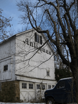
Potterstown is an unincorporated community along the border of Clinton and Readington townships in Hunterdon County, New Jersey, United States.[3] Potterstown once was home to taverns, a blacksmith, a store house, a wheelwright and a pottery shop which gave the hamlet its name.[4] It is along an old Raritan Path and on the Jersey Turnpike. Aray Van Guinea, a free African-American, donated land for the construction of the German Lutheran Church. Robert Livingston, James Alexander, his son Lord Stirling and John Stevens all owned land here at some time. John Taylor, an officer with the Hunterdon 4th Militia built a house and mill, which was used during the Revolutionary War to provide soldiers with food. Taylor's Mill has plans to become the fourth Readington Museum.
References
- 1 2 "Potterstown". Geographic Names Information System. United States Geological Survey.
- ↑ National Park Service (2009-03-13). "National Register Information System". National Register of Historic Places. National Park Service.
- ↑ Locality Search, State of New Jersey. Accessed June 9, 2016.
- ↑ Stevens, Stephanie B. Readington Township History, Hunterdon County, New Jersey. Accessed November 16, 2012.

| Topics | 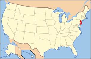 | ||
|---|---|---|---|
| Lists by county | |||
| Lists by city |
| ||
| Other lists | |||
| |||