Scotia, New York
| Scotia, New York | |
|---|---|
| Village | |
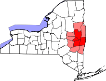
 Location in Schenectady County and the state of New York. | |
| Coordinates: 42°50′N 73°58′W / 42.833°N 73.967°WCoordinates: 42°50′N 73°58′W / 42.833°N 73.967°W | |
| Country | United States |
| State | New York |
| County | Schenectady |
| Town | Glenville |
| Area | |
| • Total | 1.8 sq mi (4.6 km2) |
| • Land | 1.7 sq mi (4.4 km2) |
| • Water | 0.1 sq mi (0.3 km2) |
| Elevation | 243 ft (74 m) |
| Population (2010) | |
| • Total | 7,729 |
| • Density | 4,400/sq mi (1,700/km2) |
| Time zone | Eastern (EST) (UTC-5) |
| • Summer (DST) | EDT (UTC-4) |
| ZIP code | 12302 |
| Area code(s) | 518 |
| FIPS code | 36-65893 |
| GNIS feature ID | 0964672 |
| Website |
www |
Scotia is a village in Schenectady County, New York, United States, incorporated in 1904. The population was 7,729 at the 2010 census.[1] Scotia is part of the town of Glenville, and is connected with the city of Schenectady by the Western Gateway Bridge[2] over the Mohawk River.
History
The land was purchased by Alexander Lindsay Glen, a native of Scotland, from the Mohawk people in the 17th century. Glen named his estate Scotia (Latin for "Scotland") after his home country.[3] Scotia was the location of a military encampment during both the French and Indian War of 1754 and again during the War of 1812.[3] During the 1800s, Scotia was known for its production of brooms, over 1 million annually for a time.[3] In the 20th century, Scotia became a thriving bedroom community for employees of Schenectady employers such as General Electric. During World War II the Scotia Naval Supply Depot (1942-1971) employed over 2000 workers.[4]
Historic buildings:
- Glen Sanders Mansion, parts dating to 1713[5]
- Abraham Glen House, 1730s
- Flint House, early 19th century[6]
- First Baptist Church, 1872[7]
- Holland House (W.T. Mynderse mansion), built 1914[8]
- Scotia Reformed Church, founded 1818, present building 1952.
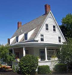
- The United States Post Office, built 1940, contains a tempera mural, The Glen Family Spared by French and Indians – 1690, painted by muralist Amy Jones (artist) in 1941. in tempera and listed on the National Register of Historic Places.[9]
Geography
Scotia is on the north bank of the Mohawk River at 42°50′N 73°58′W / 42.833°N 73.967°W (42.8313, -73.9654).[10]
According to the United States Census Bureau, the village has a total area of 1.8 square miles (4.6 km2), of which 1.7 square miles (4.4 km2) is land and 0.12 square miles (0.3 km2), or 5.82%, is water.[11]
Demographics
| Historical population | |||
|---|---|---|---|
| Census | Pop. | %± | |
| 1880 | 222 | — | |
| 1910 | 2,957 | — | |
| 1920 | 4,358 | 47.4% | |
| 1930 | 7,437 | 70.7% | |
| 1940 | 7,960 | 7.0% | |
| 1950 | 7,812 | −1.9% | |
| 1960 | 7,625 | −2.4% | |
| 1970 | 7,370 | −3.3% | |
| 1980 | 7,280 | −1.2% | |
| 1990 | 7,359 | 1.1% | |
| 2000 | 7,957 | 8.1% | |
| 2010 | 7,729 | −2.9% | |
| Est. 2015 | 7,727 | [12] | 0.0% |
As of the census[14] of 2000, there were 7,957 people, 3,233 households, and 2,014 families residing in the village. The population density was 4,661.6 people per square mile (1,796.6/km²). There were 3,410 housing units at an average density of 1,997.7 per square mile (769.9/km²). The racial makeup of the village was 96.75% White, 0.8% African American, 0.15% Native American, 1.09% Asian, 0.01% Pacific Islander, 0.20% from other races, and 0.98% from two or more races. Hispanic or Latino of any race were 1.78% of the population.
There were 3,233 households out of which 34.2% had children under the age of 18 living with them, 46.8% were married couples living together, 12.3% had a female householder with no husband present, and 37.7% were non-families. 32.8% of all households were made up of individuals and 13.7% had someone living alone who was 65 years of age or older. The average household size was 2.36 and the average family size was 3.04.
In the village the population was spread out with 26.2% under the age of 18, 5.8% from 18 to 24, 29.8% from 25 to 44, 21.5% from 45 to 64, and 16.7% who were 65 years of age or older. The median age was 38 years. For every 100 females there were 85.1 males. For every 100 females age 18 and over, there were 97.6 males.
The median income for a household in the village was $42,028, and the median income for a family was $51,449. Males had a median income of $38,074 versus $27,946 for females. The per capita income for the village was $20,386. About 5.9% of families and 6.6% of the population were below the poverty line, including 9.7% of those under age 18 and 6.0% of those age 65 or over.
Community
- Aerial photo: Collins Park and vicinity
Scotia is served by the Scotia-Glenville Central School District. Schools located in the village of Scotia include Lincoln and Sacandaga Elementary Schools, while Scotia-Glenville High School and Scotia-Glenville Middle School stand just outside the village limits. The private Mekeel Christian Academy occupies the former Scotia High School building in the village. Local residents may enjoy pastimes at all seasons in Collins Park and nearby Freedom Park. Winter events include sledding and ice skating, while summer activities include baseball, tennis, swimming, pond and river fishing, picnicking, concerts, and waterskiing on the Mohawk River.
Transportation
Scotia is served by the historic New York Route 5, and is the terminus for both Route 50 and Route 147 providing access to Saratoga County. The Route 5 link to Schenectady is over the Western Gateway Bridge, originally built in 1923-25, and replaced in 1971.[15] Scotia was formerly served by railways, including the New York Central (which operated a switch yard in the village), the Delaware and Hudson, and the Boston and Maine, as well as the electric Fonda, Johnstown and Gloversville interurban line. Two nearby airports, located in the town of Glenville, serve the village: Mohawk Valley Airport is a privately owned airport for public use located three nautical miles (6 km) along State Route 5, northwest of the village of Scotia.[16][17] Schenectady County Airport is a joint civil-military public airport located two nautical miles (3 km) north-northeast of the village of Scotia.
Notable people
- Philip Dalton (1903-1941) - military scientist and pilot
- Laura Diaz (born 1975), professional golfer on LPGA Tour, born in Scotia
- Robert Doherty (1885–1950), electrical engineer, president of Carnegie Mellon University, died in Scotia
- Saul Dushman (1883–1954), Russian-born physical chemist, resided, died in Scotia
- Conyers Herring (1914–2009), solid state physicist, born in Scotia
- Steve Kuczek (1924–2010), major league baseball player, died in Scotia
- Kathleen Paige (born 1948), rear admiral, U.S. Navy, program director, Aegis Ballistic Missile Defense
- James Parry (born 1967), Usenet personality known as "Kibo", born in Scotia
- George Runner (born 1952), California state senator, born in Scotia
References
- ↑ "Profile of General Population and Housing Characteristics: 2010 Demographic Profile Data (DP-1): Scotia village, New York". U.S. Census Bureau, American Factfinder. Retrieved July 5, 2012.
- ↑ Cardcow.com: Original photo of the first Western Gateway Bridge
- 1 2 3 Village of Scotia History
- ↑ http://dmna.ny.gov/forts/fortsQ_S/scotiaNavalSupplyDepot.htm
- ↑ Hartgen.com: Dendochronological Analyses
- ↑ Visit Scotia.com: Flint House
- ↑ First Baptist Church: History
- ↑ Bill Buell, "Dutch Touch, Mynderse house reflects Washington Irving influence," Schenectady Gazette, 25 January 2004, https://news.google.com/newspapers?nid=1957&dat=20040125&id=d4hGAAAAIBAJ&sjid=VukMAAAAIBAJ&pg=1418,5464230
- ↑ National Park Service (2009-03-13). "National Register Information System". National Register of Historic Places. National Park Service.
- ↑ "US Gazetteer files: 2010, 2000, and 1990". United States Census Bureau. 2011-02-12. Retrieved 2011-04-23.
- ↑ "Geographic Identifiers: 2010 Demographic Profile Data (G001): Scotia village, New York". U.S. Census Bureau, American Factfinder. Retrieved July 5, 2012.
- ↑ "Annual Estimates of the Resident Population for Incorporated Places: April 1, 2010 to July 1, 2015". Retrieved July 2, 2016.
- ↑ "Census of Population and Housing". Census.gov. Retrieved June 4, 2015.
- ↑ "American FactFinder". United States Census Bureau. Retrieved 2008-01-31.
- ↑ Union College.edu: Bridging the Mohawk River by Gara and Garver
- ↑ "FAA Airport Master Record" (PDF). Federal Aviation Administration. 7 May 2009.
- ↑ "Mohawk Valley Airpark (K13)" (PDF). New York State Department of Transportation.
External links
| Wikimedia Commons has media related to Scotia, New York. |
- Village of Scotia official website
- Visitscotia.com
- NY Air National Guard - 109th Airlift Wing - Scotia/Schenectady Hometown
Municipalities and communities of Schenectady County, New York, United States | ||
|---|---|---|
| City | 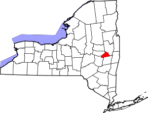 | |
| Towns | ||
| Villages | ||
| CDPs | ||
| Other hamlets | ||