Greenwich (village), New York
| Greenwich | |
|---|---|
| Village | |
 | |
_highlighted.svg.png) Location in Washington County and the state of New York. | |
| Coordinates: 43°5′29″N 73°29′50″W / 43.09139°N 73.49722°WCoordinates: 43°5′29″N 73°29′50″W / 43.09139°N 73.49722°W | |
| Country | United States |
| State | New York |
| County | Washington |
| Government | |
| • Mayor | David Doonan (G) |
| Area | |
| • Total | 1.485 sq mi (3.85 km2) |
| • Land | 1.485 sq mi (3.85 km2) |
| • Water | 0.0 sq mi (0 km2) |
| Elevation | 374 ft (114 m) |
| Population (2000) | |
| • Total | 1,902 |
| • Density | 1,280.4/sq mi (494.4/km2) |
| Time zone | Eastern (EST) (UTC-5) |
| • Summer (DST) | EDT (UTC-4) |
| ZIP code | 12834 |
| Area code(s) | 518 |
| FIPS code | 36-30675 |
| GNIS feature ID | 0951780 |
Greenwich is a village in Washington County, New York, United States. It is part of the Glens Falls Metropolitan Statistical Area.[1] The village population was 1,902 at the 2000 census.[2] Locals pronounce the name as it appears, in contrast to Greenwich ("Grehn-itch"), England. Greenwich was formerly known as Whipple City.
The Village of Greenwich is located at the south town line of the Town of Greenwich; a small part of the village is in the Town of Easton. The village developed on both sides of the Battenkill River and is served by Route NY-29.
History
This area was settled by European Americans after the American Revolutionary War, as migrants moved into New York from New England. The community was originally named Whipple City after Job Whipple, the owner of a successful cotton mill (1804). In 1809, the community set itself off from the town by incorporating as Union Village. Cotton and textile manufacturing, based on cotton from the Deep South, continued to be a profitable industry in the village for some time through the 19th century. It connected the villagers to the economy of King Cotton. In 1867 the village changed its name to Greenwich.
An important station of the Underground Railroad was located in Greenwich, and local people helped fugitive slaves reach freedom in upstate New York or Canada. A historical marker, containing a map showing locations of safe houses and commemorating Greenwich's contribution to the Underground Railroad, was dedicated in 2004.
United States President Chester A. Arthur attended prep school in Greenwich while his father served here as pastor at Bottskill Baptist Church.
The Village of Greenwich Historic District was listed on the National Register of Historic Places in 1995.[3]
Geography
According to the United States Census Bureau, the village has a total area of 1.485 square miles (3.85 km2). None of the area is covered with water.
The Batten Kill, a river in the south part of the town, has historically provided power. It has attracted many settlements, besides Greenwich village, along its course.
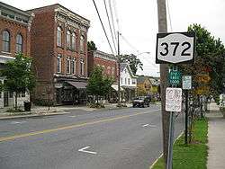
New York Route 29 passes through the village from east to west. The northern terminus of New York Route 372 is in the village, where it joins NY-29.
Demographics
The village had its peak of population in 1920. A decline in manufacturing in the area led to a loss of jobs; in addition, urbanization attracted people to larger cities.
| Historical population | |||
|---|---|---|---|
| Census | Pop. | %± | |
| 1880 | 1,231 | — | |
| 1890 | 1,663 | 35.1% | |
| 1900 | 1,869 | 12.4% | |
| 1910 | 2,314 | 23.8% | |
| 1920 | 2,384 | 3.0% | |
| 1930 | 2,290 | −3.9% | |
| 1940 | 2,270 | −0.9% | |
| 1950 | 2,212 | −2.6% | |
| 1960 | 2,263 | 2.3% | |
| 1970 | 2,092 | −7.6% | |
| 1980 | 1,955 | −6.5% | |
| 1990 | 1,961 | 0.3% | |
| 2000 | 1,902 | −3.0% | |
| 2010 | 1,777 | −6.6% | |
| Est. 2015 | 1,744 | [4] | −1.9% |
As of the census[2] of 2000, there are 1,902 people, 788 households, and 493 families residing in the village. The population density is 1,280.4 inhabitants per square mile (494.4/km2). There are 852 housing units at an average density of 573.6 per square mile (221.5/km2). The racial makeup of the village is 98.11% White, 0.32% Black or African American, 0.05% Native American, 0.63% Asian, 0.11% from other races, and 0.79% from two or more races. 0.74% of the population are Hispanic or Latino of any race.
There are 788 households out of which 33.9% have children under the age of 18 living with them, 46.1% are married couples living together, 11.5% have a female householder with no husband present, and 37.4% are non-families. 31.5% of all households are made up of individuals and 15.2% have someone living alone who is 65 years of age or older. The average household size is 2.41 and the average family size is 3.06.
In the village the population is spread out with 27.2% under the age of 18, 7.6% from 18 to 24, 28.8% from 25 to 44, 21.5% from 45 to 64, and 14.9% who are 65 years of age or older. The median age is 37 years. For every 100 females there are 97.1 males. For every 100 females age 18 and over, there are 88.3 males.
The median income for a household in the village is $34,659, and the median income for a family is $42,198. Males have a median income of $31,951 versus $20,795 for females. The per capita income for the village is $16,592. 8.3% of the population and 4.8% of families are below the poverty line. Out of the total population, 7.7% of those under the age of 18 and 9.6% of those 65 and older are living below the poverty line.
References
- ↑ "Metropolitan Areas and Components, 1999, with FIPS Codes". US Census Bureau. Retrieved July 7, 2009.
- 1 2 "American FactFinder". United States Census Bureau. Retrieved 2008-01-31.
- ↑ National Park Service (2009-03-13). "National Register Information System". National Register of Historic Places. National Park Service.
- ↑ "Annual Estimates of the Resident Population for Incorporated Places: April 1, 2010 to July 1, 2015". Retrieved July 2, 2016.
- ↑ "Census of Population and Housing". Census.gov. Retrieved June 4, 2015.
External links
| Wikimedia Commons has media related to Greenwich (village), New York. |
Municipalities and communities of Washington County, New York, United States | ||
|---|---|---|
| Towns | 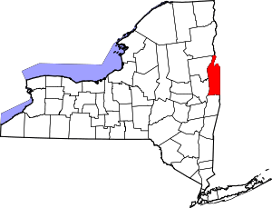 | |
| Villages | ||
| Hamlets | ||
| Footnotes | ‡This populated place also has portions in an adjacent county or counties | |